
22 April 2022
Understanding the deadly landslides in the Durban area of South Africa
Posted by Dave Petley
Understanding the deadly landslides in the Durban area of South Africa
In the last week I have posted extensively about the deadly landslides on 11 April 2022 in the Philippines. At around the same time an event of a similar scale occurred in a completely different location. It is reasonable to ask why I have not written about that one.
The event in question occurred in the Durban area of South Africa. Once again it was triggered by heavy rainfall. Reliefweb posted an update on this event yesterday – the statistics are appalling:
According to national authorities, 443 people died in KwaZulu-Natal and over 40,000 are missing. More than 40,000 people have been displaced, while nearly 4,000 houses were destroyed and more than 8,000 others were damaged, mostly across Durban City and its surrounding areas. A National State of Disaster has been declared in response to the floods and landslides, and rescue teams have been deployed to the affected areas to provide humanitarian assistance to those most affected.
Hopefully the number missing is primarily the result of challenges of documenting displaced people, but even if the death toll remains at its current level, the picture is truly grim.
The challenge that I have had with this event has been obtaining reliable information about what has actually happened. It is not at all clear to me as to why this is the case. However, The Conversation has now published an article by Stellenbosch University, who provides a readily understandable explanation for the underlying causes of the landslides in this area. It is worth a read – the underlying problems are weak geology.
In the coastal region, the problems are associated with a large, vegetated dune formation that is prone to rapid erosion:
Ground adjacent to the sea from Durban to Mtunzini (a coastal town 140km north of Durban) is almost exclusively made up of ancient red sand dunes termed the Berea formation. South of the Durban harbour these sands form a ridge called the Bluff and north of the harbour they form the Berea Ridge. In some places these sand dunes are extremely steep…The investigation showed the slopes’ stability was not significantly affected by rainfall. That makes sense as these slopes have been battered by storms over geological time. But concentrated flows from poorly controlled flood water or broken water pipes were found to be catastrophic.
This is dramatically illustrated at the town of Umdloti:-
Highly destructive gully formation at Umdloti, near to Durban in South Africa. Image from the North Coast Courier.
.
Meanwhile, inland the geology also causes problems. Part of the area is underlain by the shales of the Pietermaritzburg formation, which consist of thin layers of clay and silt. These shales weather easily and trap high pore water pressures, making them very susceptible to failure. Other parts of the region are underlain by sandstones of the Natal group, which also contain layers of clay that trap high pore water pressures.
Understanding the distribution of these landslides, and the associated floods, is going to be a challenge but is urgently needed. Meanwhile, the best pictoral record I can find has been posted to Facebook by Kierran Allen Photography. This is an example of one of their images:-
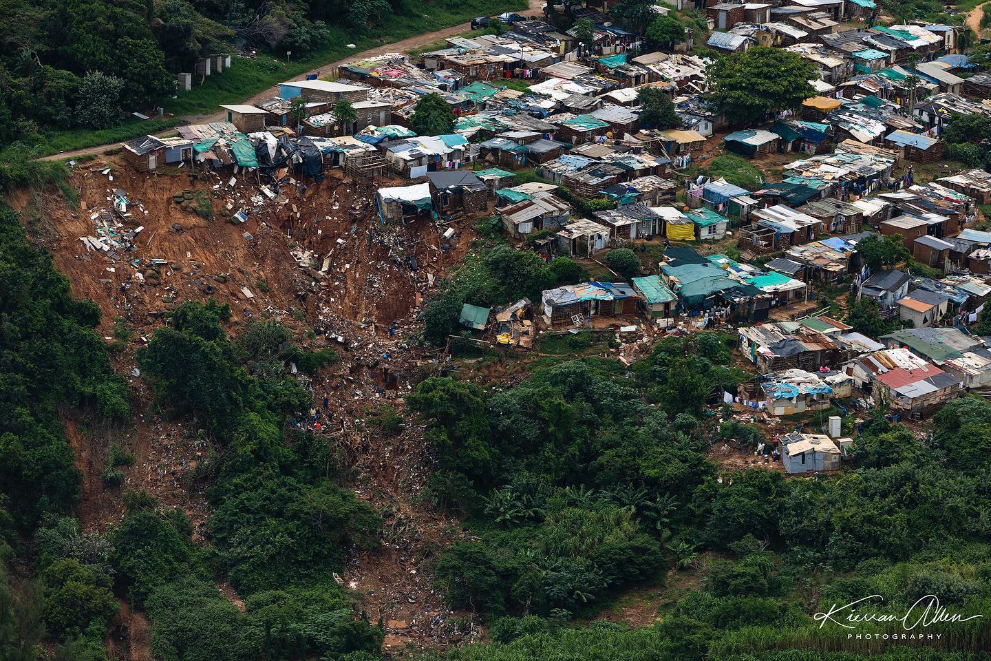
A landslide in the Durban area of South Africa, triggered by the April 2022 rainfall event. Image by Kierran Allen Photography.
.
The devastating impact of such a landslide, even though it is small, is clear to see.
 Dave Petley is the Vice-Chancellor of the University of Hull in the United Kingdom. His blog provides commentary and analysis of landslide events occurring worldwide, including the landslides themselves, latest research, and conferences and meetings.
I want to write essay about mass movement