
4 May 2022
The Claxton Bay landslide in Trinidad
Posted by Dave Petley
The Claxton Bay landslide in Trinidad
The residents of a community in Belle View in the Claxton Bay area of Trinidad in the Caribbean are having their lives destroyed by a landslide. The failure started to damage the houses in September 2021; to date six houses have been affected. Last week the residents received a letter from the owners of a quarry downslope from the site, informing them that their houses are likely to suffer further damage in the rainy season.
This image, from the Trinidad Guardian, shows the scale of the problem:-
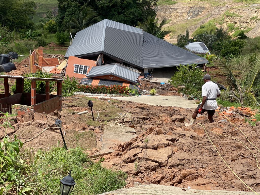
Landslide damage from the landslide at Claxton Bay in Trinidad. Image by Ivan Toolsie via the Trinidad Guardian.
.
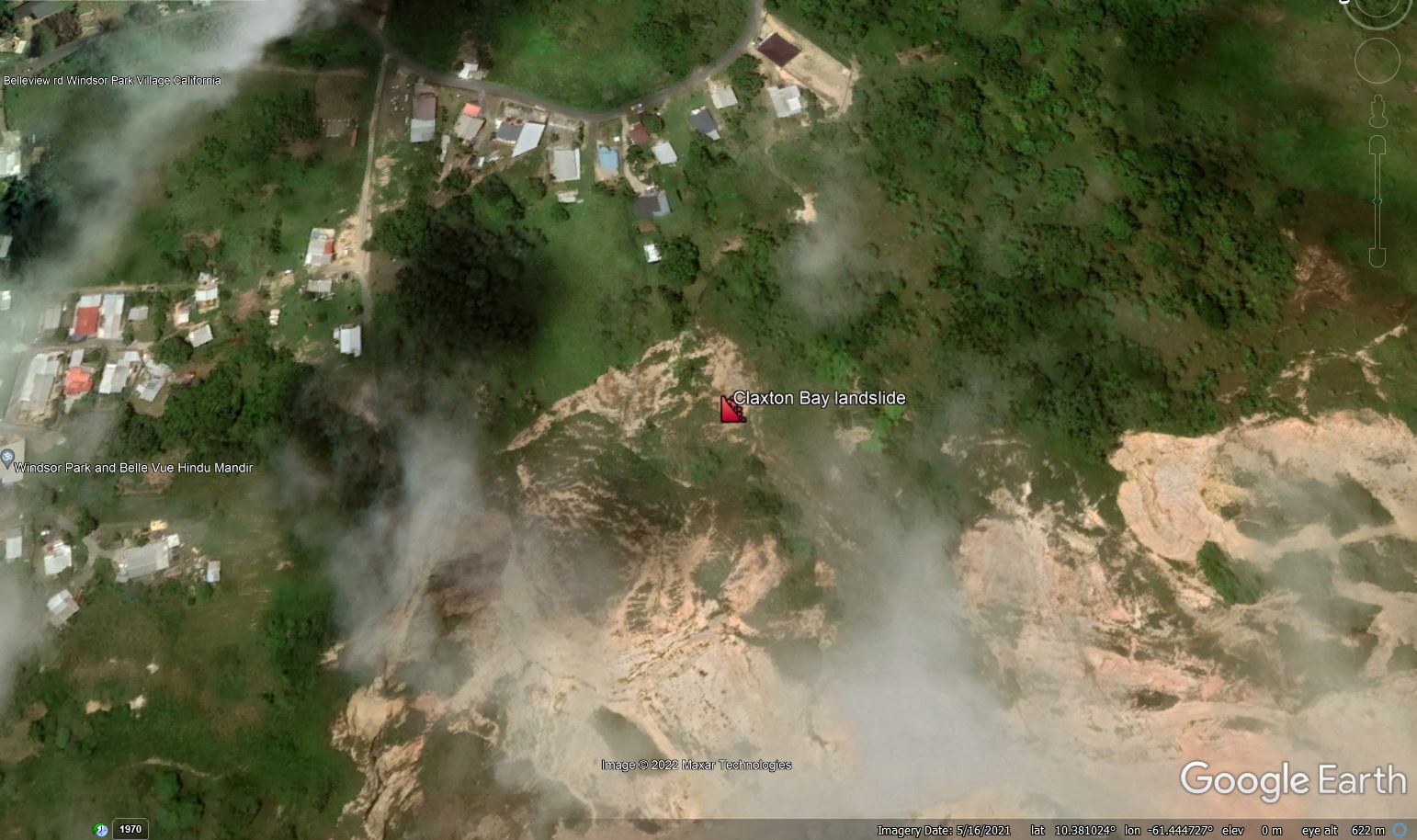
I believe that the location of the landslide is 10.381°, -61.445°. This is a Google Earth image of the site, dated May 2021:-
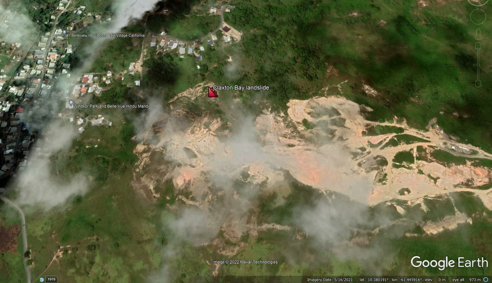
Google Earth image of the site of the Claxton Bay landslide in Trinidad, collected in May 2021, before the landslide retrogressed to affect the houses.
.
The key features here are the quarry on the downslope side, the clear active landslide beneath the marker, and the houses at the top of the slope (top of the image). This image was collected before the landslide retrogressed to affect the houses.
The historical image set for this site is really interesting and very informative. An image from February 2015 shows active quarrying at the site, and the creation of a steep slope on the quarry face:-
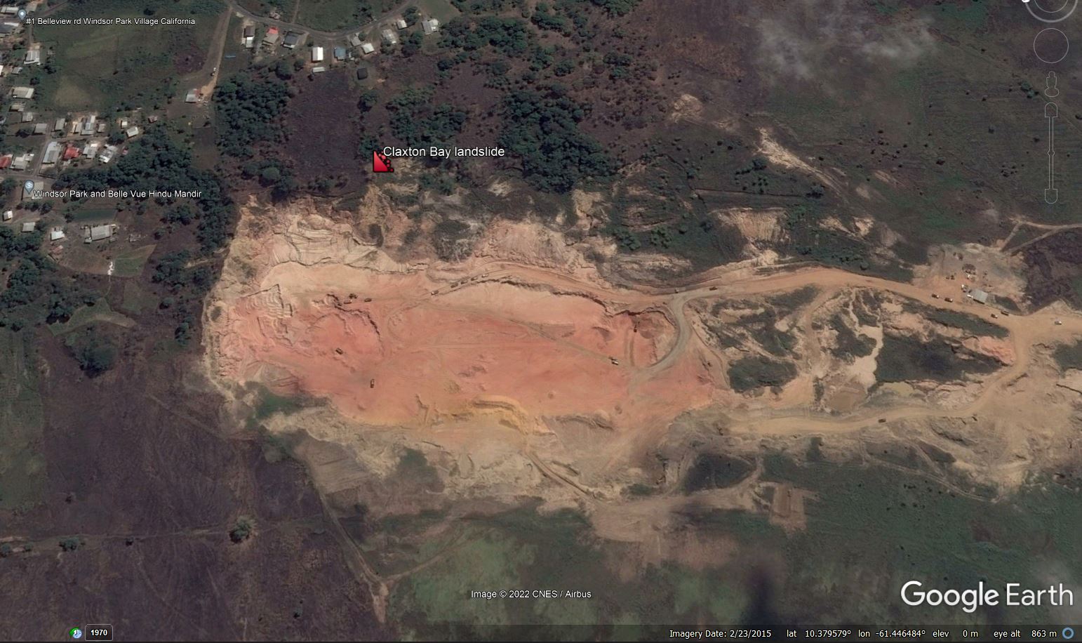
Google Earth image of the site of the Claxton Bay landslide in Trinidad, collected in February 2015, before the landslide retrogressed to affect the houses.
.
By January 2016 the situation had changed considerably. The intensity of quarry activity appears to have been lower, but a landslide had started to develop in the wall of the quarry, immediately to the right of the marker in the image. Two clear lobes had developed, one of which had impinged significantly into the workings. Land was being lost from below the houses:-
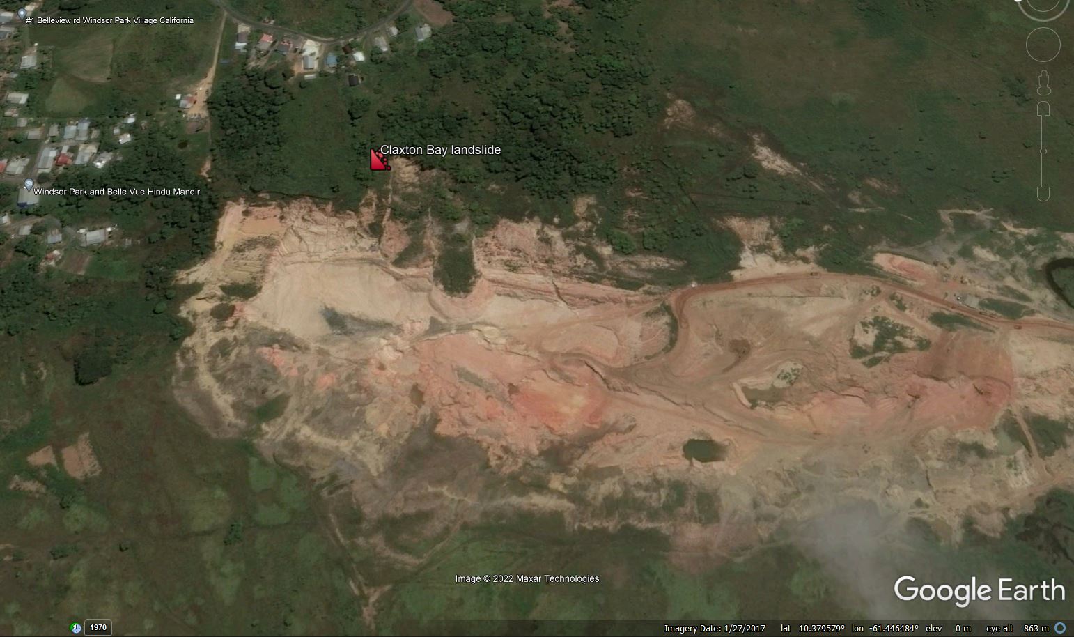
Google Earth image of the site of the Claxton Bay landslide in Trinidad, collected in January 2017, before the landslide retrogressed to affect the houses.
.
By November 2018 the landslide had developed very significantly. The head scarp of the main failure had retrogressed by about 100 metres, the landslide had widened and the lobes had extended much further into the quarry:-
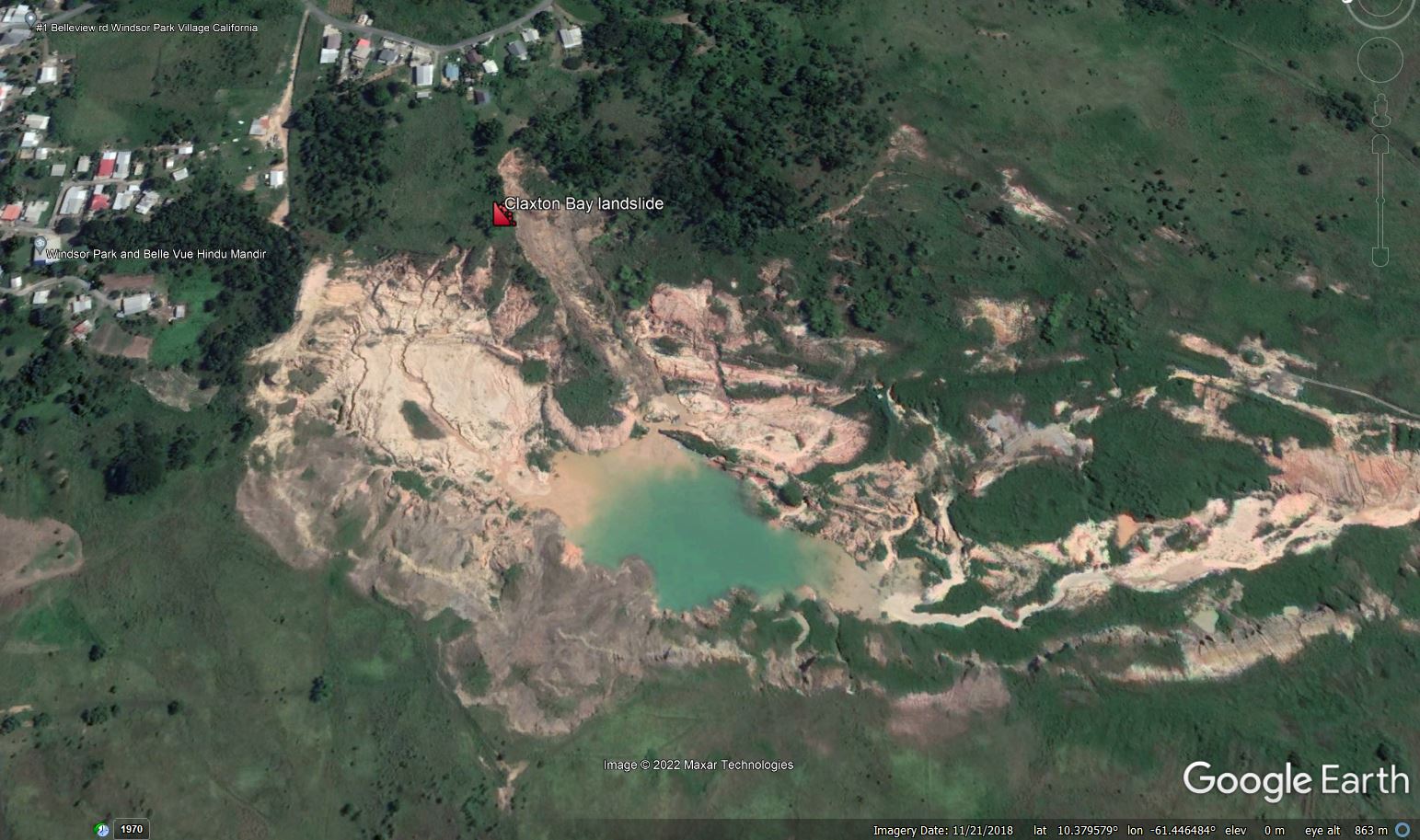
Google Earth image of the site of the Claxton Bay landslide in Trinidad, collected in November 2018, before the landslide retrogressed to affect the houses.
.
It also appears that the remaining unfailed portion of the slope was degrading rapidly.
The image in May 2021, although partially affected by cloud, shows that a much larger failure had developed. This is zoomed in view from that time:-
Zoomed in Google Earth image of the site of the Claxton Bay landslide in Trinidad, collected in May 2021.
.
It is not difficult to see how a further episode of retrogression has directly impacted the houses.
It is interesting to note that the letter from the owner of the quarry is explicit that it does not accept liability for the landslide. Readers will be able to come to their own conclusions as to whether this is a reasonable position.
 Dave Petley is the Vice-Chancellor of the University of Hull in the United Kingdom. His blog provides commentary and analysis of landslide events occurring worldwide, including the landslides themselves, latest research, and conferences and meetings.
I suggest from my father’s and my own old research and a widespread outlook with common or proper substance from before MM=2000.
Up left houses may move there, more seemingly difficult changes there. Som else most view fall perhaps partly. I suggest research compromise out the usage of masses and include the weak crack and small sinkholes that co-exist by factors. Most of such nearby roads can seem false to same factors from very local source, even a tremor fall. Restrictions for applying masses on areas can be the problem. The masses can behave likely similar to a lahar and prompt a vent nearby or reaching the crack. Even a deep. Or/and else. If a “foreign” mass up-come or sink must also include these factors. Nature is brought down on it, can also be an old problem that soon hide a built reason. Water or not… Surrounding affections. This world is weak. Where small amounts of humidity or else make a problem. Such areas are recommended health controls. And what health control is there really living on ground when something happen? Clearly prompt I see that a reaction is to be expected, just like then. Anyhow, hope that went ok. There is a hangover now?
Apply source for asbest and gases measuring? Geology is interesting.
Advice. Check tree-roots, types. It is there first.
Now you learn how to come home. Good luck.
Another factor to check out. Fungus.
More is trend now, cactuses and coconut trees. A small lava may bury all dry on spot and near in a built cave.
You have a ship, a small island and vehicles near…
Have a look also at the small bumps up right.
Same and livestock there…
It will depend on when the quarry started. Was it there before the house development, or after?
[Surely the owners of the quarry have a duty to ensure that the landslide does not affect surrounding land, even if the works predate the houses? D.]
A perfect case for the NEED of active monitoring with terrestrial or satellite radar here. The remaining properties can all be easily assessed for risk, and annual rates updated monthly at very low cost. [email protected].