
21 November 2011
Collapse of the San Pedro landslide
As expected, the San Pedro landslide in California that I highlighted last week has now failed, with a substantial movement event that has caused complete destruction of the road. The final collapse, which happened on Sunday afternoon, appears to have been associated with a rainstorm, but as this is a progressive failure it is not really valid to define this as a trigger. BBC News has a nice video of the site, whilst the Daily Breeze has a gallery of images, including this one:
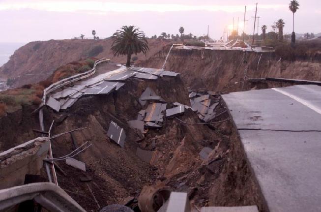
http://lang.dailybreeze.com/photos/photos.asp?a=1365655#id=1365655&num=2
The video suggests that there is still a substantial volume material in a quite precarious state on the slope, such that further large movements at the front (cliff side) of the slide are likely. For this reason it is important that the exclusion zone around the landslide, especially on the beach, is maintained.
Rebuilding the road on the existing alignment is likely to be very expensive at best.
18 November 2011
Landslides in Art part 12: Low Tide by Arthur Homeshaw
Summary: A new post in the series on the ways in which landslides are depicted in art: this time Low Tide by Arthur Homeshaw
It has been a long time since I have posted in my series on landslides in art (part 11 was as long ago as May!), so in celebration of the opening of the Christmas exhibition at the Bianco Nero Gallery tonight, I thought it was time that I put this right. Thanks to Nick Rosser for bringing this image to my attention. Part 12 focuses on a painting by the British Artist Arthur Homeshaw, who sadly died earlier this year. Homeshaw taught art at Queen Elizabeth’s School in Crediton, Devon until his retirement in 1992. He was a highly respected artist, with work in the Victoria and Albert Museum.
The piece below is a linocut entitled Low Tide:
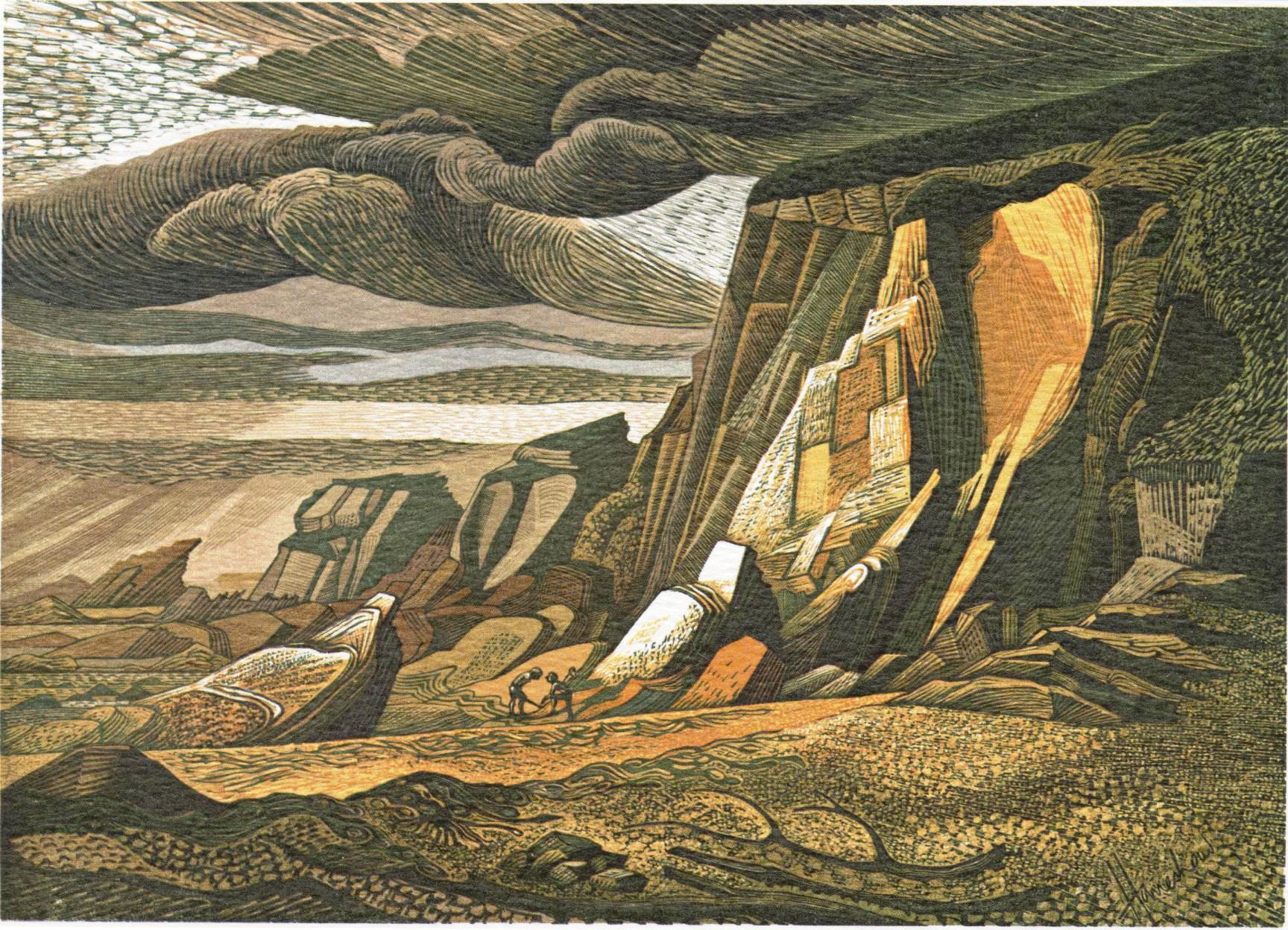
There are a number of interesting aspects to this image that resonate deeply. First, the picture has a slightly threatening air, and a sense of loneliness and perhaps danger for the two individuals digging at the bottom of the cliff. The stormy skies suggest bad weather to come. Second, the attention to detail means that the geological structure – and in particular the steep dips in the rocks – are well-captured. There is a change in the dip between the cliff and the foreshore, suggesting a complex geological setting. Note the face parallel fractures in the rock face – surely a clear illustration od stress release jointing? High on the rock face above the people is a fresh rockfall scar, with some evidence of blocks below. The pseudo-arrow from the slope indicates the movement, but the material has been mostly removed. To the left is a block that looks to be next to go, but as this is directly above the people the lurking risk is evident.
The site reminds me of some ongoing and recent landslides, such as the San Pedro slide in California (which appears to be accelerating), the recent cliff collapse in Wales, and this fatal cliff collapse event in Spain.
17 November 2011
Blogging on Hazard, Risk and Disasters
Yesterday I gave a lecture to our MSc programme on Hazard and Risk here in the Institute of Hazard, Risk and Resilience at Durham University. Below are the Powerpoint slides that I used for the lecture:
[authorSTREAM id= 1252014_634571164391418750 pl= player by= Dr_Dave]
The lecture consists of a genral introduction to why I blog, a long and detailed case study of the Attabad landslide, and some reflections on the pros and cons of blogging, and potential problems and impacts.
15 November 2011
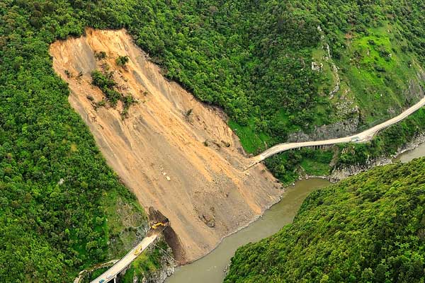
Interesting coastal landslide in San Pedro, California
News today of an ongoing landslide affecting San Pedro in California. This slide, which has developed over the last few weeks, has closed the coast road. Real concern about the site emerged a couple of weeks ago; since then the problem has become far worse. At the moment I can’t find a decent still image of the site, but this still from this news report gives an idea of the magnitude of the problem (NB this is definitely not a sinkhole – it is a landslide):
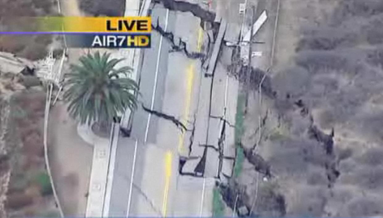
Fortunately, it is only the road and utility lines that are threatened.
The site is well-covered by Google Earth imagery. This is the most recent perspective view from March this year:
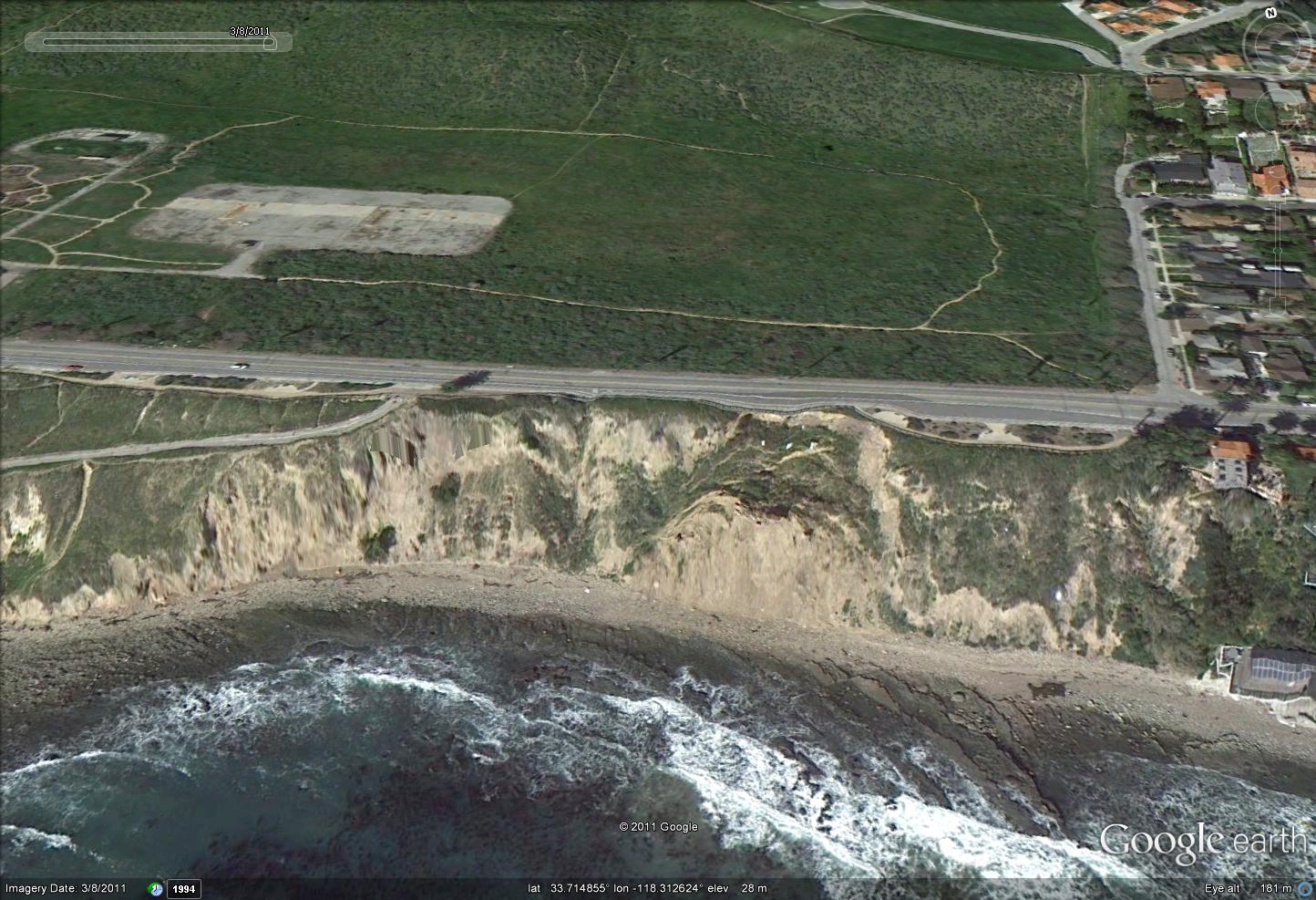
Compare that with an image from two years ago:
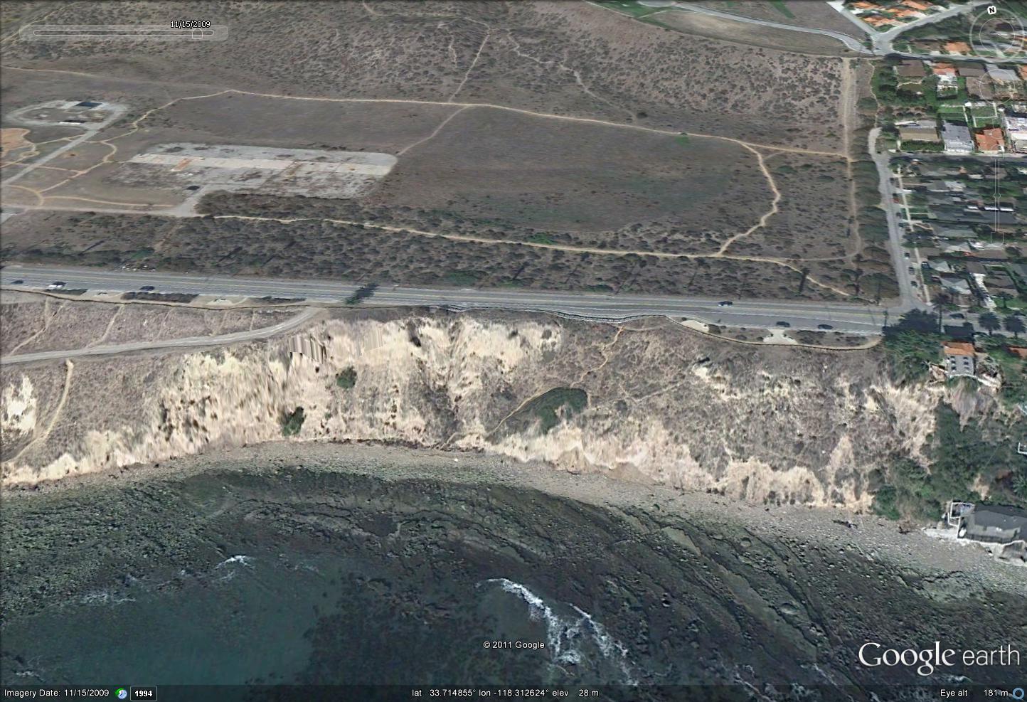
There has been a very noticeable loss of material on the right side(from this view) of the landslide, which shows the development of a progressive failure. I would anticipate that the loss of this buttress has destabilised the remainder of the slope. Thus, at least on first inspection, this just looks to be a natural failure caused by erosion by the sea. Where the road is so close to the cliff edge, and materials are weak, this is to be expected.
Repair of such a section would be very expensive and environmentally damaging as a large toe support will be needed, with a large volume of fill behind. Relocating the road inland looks to be the sensible option, if that is possible.
Any comments from those nearer the scene? Any better news reports?
New paper on landslide-dams and genetic change in fish
![]()
Summary: A review of a new paper that has identified a new, large, ancient landslide in northern California. The landslide dam had a surprising impact on the local fish population
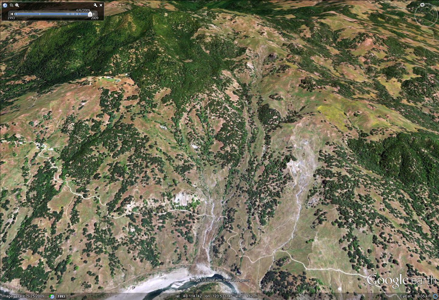
A fascinating paper (Mackey et al. 2011) was published yesterday in PNAS on the role that a palaeo-landslide can play in driving genetic change in fish species. The site is located on the Eel River in northern California. Using airborne LIDAR the research team have identified a landslide scar and the remains of a landslide dam blocking the river. The LIDAR data show the landslide very clearly:
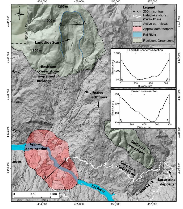 This is an interesting case that really demonstrates the value of LIDAR data. Spotting this landslide scar from conventional imagery would be very difficult indeed, but once you know what you are looking for it is quite clear in the landscape, as shown on this Google Earth perspective view:
The landslide is dated at between 22.6 and 25.7 ka (i.e. about 22,500 before the present), and the scar on the hillside has a volume of about 36 million cubic metres. Upstream of the landslide dam there are planar surfaces and terrace deposits that indicate that the lake trapped behind the dam at least partially filled with sediment. This gives an indication of the maximum height of the dam, even though the landslide deposit itself has been mostly removed. This comes out at about 130 m above the channel floor, whilst the deposits suggest that the resulting lake was 55 km long and had a volume of 1.3 cubic kilometres.
Based on estimates of rates of sediment delivery, the lake took between 600 and 6000 years to fill with sediment. It is not known whether the dam failed catastrophically or incrementally, but it is interesting in the context of Attabad to note that some sort of breach event did occur even after this long period. This area is of course seismically-active, so it is possible that the cause of the breach was an earthquake. The morphology of the scar, and in particular the location at the very top of the slope, might hint at earthquake triggering for the initial failure as well.
An interesting twist in this paper comes with the potential impact on the fish population. The river contains two ecotypes of anadromous Pacific Steelhead trout. Both spawn by migrating upriver, but at different times and in different locations, which means that they do not interbreed. This is common in western North America. However, in the Eel River the two species are much genetically-closer than elsewhere. The authors hypothesise that for the prolonged period in which the dam was in place, the fish had to breed below the blockage, which allowed the two ecotypes to interbreed. The resulting hybridization is exceptionally rare in the natural world.
This is an excellent paper that is well worth reading. Although not stated in the text, the implications of this research for other landslide dams, and for locations in which rivers are being blocked by manmade barrages, are clear.
Reference
Benjamin H. Mackey, Joshua J. Roering, & Michael P. Lamb (2011). Landslide-dammed paleolake perturbs marine sedimentation and drives genetic change in anadromous fish Proceedings of the National Academy of Sciences : 10.1073/pnas.1110445108
11 November 2011
Drawdown landslides in muddy sediments at the Condit Dam
Summary: The remarkable slope failures in the sediments at Lake Condit in Washington State USA, which were caught on video, illustrate the processes associated with slope failure during rapid draw-down.
One of the most intriguing landslide phenomena is that of drawdown instabilities in reservoirs and lakes. The idea is simple. When, for example, a new reservoir is built the changed water level in valley causes an increase in water level in the slopes. Sometimes, as in Vaiont, this can have unfortunate implications, and indeed it is these landslides that have caused so many problems on the banks of the Three Gorges reservoir in China. However, the real problems can start if the water level in the reservoir rapidly falls, which briefly leaves the high water levels in the slopes. This excess water then drains downslope through the soil and rock, generating an additional hydraulic force that acts to destabilise the slope. Finally, there may also be an effect of the loss of toe support that was provided by the water at the base of the reservoir bank, which may also act to destabilise the slope.
The upshot is that at least in theory rapid drawdown of a lake or reservoir can be bad news for the stability of the banks. For this reason, drawdown is usually undertaken slowly for very large reservoirs where instability is an issue. There are a few cases where rapid drawdown has been observed to cause major problems. Perhaps the best example is the Hattian Bala landslide lake in Pakistan, which was created in the 2005 Kashmir earthquake. The landslide dam breached catastrophically in early 2010, and the lake rapidly drained. The upshot was a series of landslides on the flanks of the lake that were highly destructive. The aftermath is caught rather nicely on this recent Google Earth image of the site:
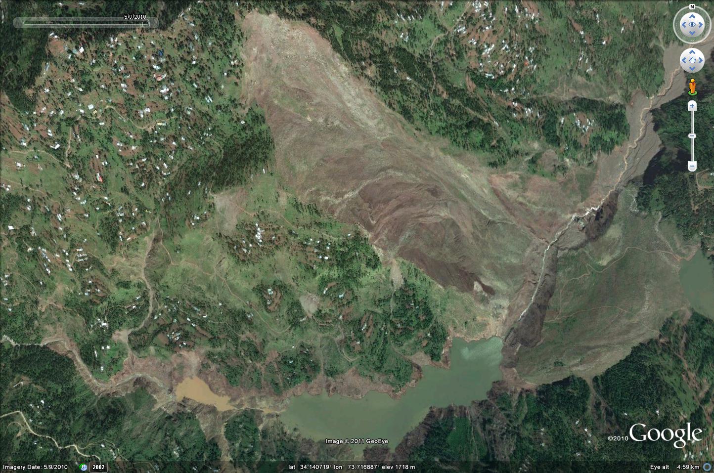
The landslide is the unvegetated mass in the upper centre of the image, with the remains of Karli Lake trapped behind the rump of the dam (visible at the bottom of the image). The slope failures along the banks can be seen with care, especially in the upper reaches of the old lake (near the rather muddy pool).
However, this process is quite poorly constrained and needs more research, though opportunities to do this are rare.
Interestingly, in the USA some old dams are now being removed for environmental reasons. This process is being undertaken with great care, and is in areas in which rapid drawdown is not likely to be a major a problem that is likely to affect the flanks for the lake. But, within these lakes vast volumes of sediments have accumulated that are in themselves prone to slope instability during rapid drawdown. The process is just the same as the above, but in this case the sediments are very weak and of course water saturated. The upshot is that they are inevitably unstable during drawdown, providing a perfect opportunity to examine this type of instability.
The Condit Dam in Washington state was breached explosively on 26th October 2011, resulting in rapid drawdown of the lake. The water level in the reservoir banks responded by falling, resulting in home owners noting that their wells have dried up. Interestingly though, a video was taken of the drop in water level, and response of the silt in the reservoir bed, after the lake level fell. This is a remarkable illustration of the landslide process in action:
The most interesting part of the video occurs from about 1 min 20 seconds into the video, when the recording is shown speeded up. As the lake level falls the muddy sediment in the banks slumps downwards – note how the process is episodic, not continuous, by the way. Towards the end a flow comes down the main channel in a series of pulses as well, and indeed this elevates the lake bed of the channel briefly.
This muddy material will be quite quickly eroded by the river once the main dam structure has been removed and some large flows come down the main channel. It is likely however that the homeowners will need to drill some deeper wells if they wish to get water from that source.
Finally, other dam removal projects are planned in the USA. There is a wonderful research opportunity if piezometers (instruments to measure water pressure) could be installed in the sediments (not a difficult task in itself), and a high-speed laser scanner were to be used to monitor the deformation of the materials as the lake level fell. This would generate a wonderful dataset that would greatly help in understanding slope failures in these types of materials and during rapid lake level changes.
As a footnote, can I say thanks to all those who pointed out this video to me. I am sorry that it has taken so long to put the post together!
10 November 2011
A round-up of new landslide stories
Summary: Brief reports and updates on landslides in Colombia, Libya, New Zealand and China
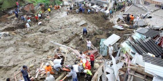
First off, rescue and recovery operations at the Manizales landslide site in Colombia appear now to have finished. The final death toll is 48 people, making it one of the largest landslides of the year.
Meanwhile, Youtube has a slightly intriguing video about a landslide in Libya earlier this week:
The reported death toll is 22 people, but I cannot track down any more information.
The Manawatu Gorge landslide in New Zealand continues to cause major problems, according to this report.
http://www.stuff.co.nz/national/5942291/Manawatu-Gorge-bill-9-million
So far the estimated costs exceed £4.5 million, and the road is likely to remain closed until the New Year.
China suffered a landslide on Wednesday morning that killed two people. It occurred in Shuangbai county in Yunnan province. Another person is reportedly missing.
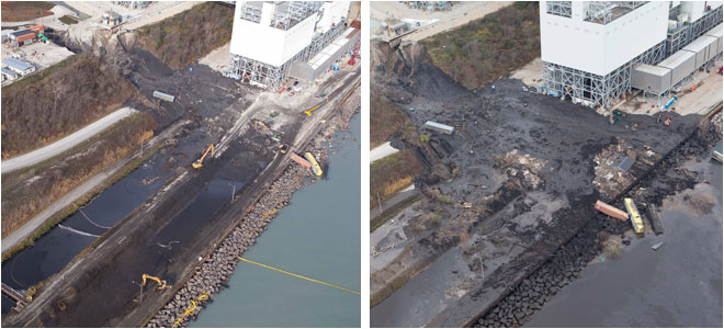
Finally, clean up operations continue at the Oak Creek power station landslide site in the USA, as this before and after slide shows (the image on the left is the newer one):
http://www.jsonline.com/news/milwaukee/sierra-club-files-suit-contending-coal-ash-poses-risks-3p305i6-133586473.html
It appears that the operator is now facing potential legal action over the release of coal ash into the lake, so it could turn out to be a very expensive landslide.
8 November 2011
Rising trends in landslides in Colombia
Summary: A review of landslide impacts since 2002 in Colombia.
The landslides in Colombia yesterday are a reminder of the heavy toll that mass movements inflict on that country. The largest event, at Manizales, is now known to have killed 39 people, with a further 20 still reported to be missing. Unfortunately, this reflects a rising trend in landslide impacts in Colombia that is of great concern. The graph below shows the recorded number of fatality-inducing landslides in Colombia from 2003 to the present, as recorded in the Durham Fatal Landslide Database. The bar graph shows the number of recorded fatalities from landslides, whilst the line graph shows the number of recorded landslides:
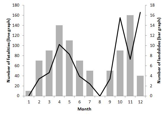
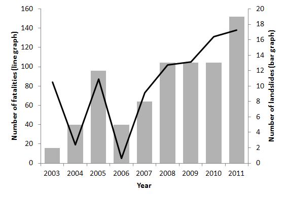 The trend in the graph is clear, with an increasing landslide impact with time both in terms of numbers of events and the numbers of lives lost as a result. Of course the data for 2011 only extends to early November (but does include the most recent events), so may well increase further. An analysis of the timing of the landslides by month (below) shows that November is the peak landslide period (the number of landslides (i.e. the bar graph) is a better guide here than is the number of fatalities, as the latter is a much more noisy dataset):
 The causes of this dramatic rise in landslide occurrence and impacts not clear to me, though I suspect that the usual suspects (population growth, urbanization, deforestation, road construction, etc) lie at the root of the problem. It would be interesting to hear whether anyone based in that part of the world can comment? What is clear is that there is an urgent need to start to reduce landslides impacts in Colombia – perhaps a programme similar to this one in Vietnam is needed.
7 November 2011
Landslides in Colombia on Saturday
Summary: On Saturday two landslides occurred in Colombia. The largest, in Manizales, killed at least 29 people.
Heavy rainfall in Colombia on Saturday triggered landslides in Colombia. Whilst reports vary somewhat as to the actual cost of these landslides, it appears that there were two major events. The largest occurred at Manizales, where 16 houses were buried at 6 am. In total 29 people were reported killed and about 20 remain missing. There seems little chance of finding any further victims alive, judging by the images of the landslide:
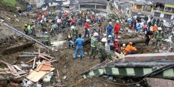
http://www.eltiempo.com/colombia/eje-cafetero/deslizamiento-en-manizales_10714165-4
http://www.eltiempo.com/colombia/eje-cafetero/deslizamiento-cerca-del-centro-de-manizales_10711024-4
Meanwhile, a further landslide occurred at Calarca in Quindio, reportedly killing four people and injuring another five people.
Landslides have been a very serious problem in Colombia in recent years – see for example previous posts here, here and here, and this landslide video.
4 November 2011
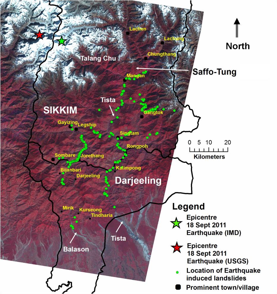
Geological Survey of India report on landslide from the Sikkim earthquake
http://www.portal.gsi.gov.in/gsiDoc/pub/report_portal_final_20102011.pdf
Summary: A new Geological Survey of India report describes some of the landslides triggered by the September 2011 Sikkim earthquake in India and Nepal
The Geological Survey of India has posted online a (2 MB) pdf document containing a report about landslides triggered by the Sikkim earthquake. The report is based upon a field reconnaissance visit undertaken by a group of geologists shortly after the event, and thus inevitably concentrates on those slides that were accessible (i.e. close to roads). In most cases these are the ones that affected the population, so that is not unhelpful.
In total, 210 landslides were noted along 12 road sections. These are mostly rockslides. Interestingly, most were first time failures – indeed the report notes that existing landslides were not reactivated in most cases. It is also interesting to note that “a large number of earthquake induced rockslides occur proximal to the crest portions of its steep ridges and in its westward higher slopes, which perhaps indicates the effect of the topographic amplification of earthquake induced ground motion in these steep rocky mountain faces.” This directionality effect is similar to my observation based on satellite imagery a month or so ago. As the report notes, it would be really interesting to map properly the landslide distribution from this earthquake using high resolution imagery. Now that the monsoon has ended it should be possible to gain a good image in the next few months.
It is interesting to note that there is almost no information about landslides triggered by the earthquake in Nepal.
 Dave Petley is the Vice-Chancellor of the University of Hull in the United Kingdom. His blog provides commentary and analysis of landslide events occurring worldwide, including the landslides themselves, latest research, and conferences and meetings.
Recent Comments