21 November 2011
Collapse of the San Pedro landslide
Posted by Dave Petley
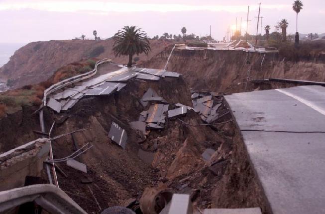
As expected, the San Pedro landslide in California that I highlighted last week has now failed, with a substantial movement event that has caused complete destruction of the road. The final collapse, which happened on Sunday afternoon, appears to have been associated with a rainstorm, but as this is a progressive failure it is not really valid to define this as a trigger. BBC News has a nice video of the site, whilst the Daily Breeze has a gallery of images, including this one:
The video suggests that there is still a substantial volume material in a quite precarious state on the slope, such that further large movements at the front (cliff side) of the slide are likely. For this reason it is important that the exclusion zone around the landslide, especially on the beach, is maintained.
Rebuilding the road on the existing alignment is likely to be very expensive at best.


 Dave Petley is the Vice-Chancellor of the University of Hull in the United Kingdom. His blog provides commentary and analysis of landslide events occurring worldwide, including the landslides themselves, latest research, and conferences and meetings.
Just sending you an update on the San Pedro landslide. Approximate location is 33.715100°, -118.312185°. We have had some heavy rains over the weekend so a nice sized chunk of rock hastened its slip into the ocean last night. Here’s a video clip http://www.nbclosangeles.com/news/local/San-Pedro-Landslide-Cliff-134238418.html. I will look for more footage through the day. The local residents are notably upset. I wish there was a way to let them know that: 1) For the very long term, yes portions of the area could potentially be unstable. 2) No, they will not become an island like Catalina (located 35 km south of this region); and 3) Although Facebook is a wonderful medium for getting messages out quickly, one must take it all with a grain of salt and look a bit further when posible.
This area consists of a series of marine terraces unconformably sitting on Miocene sedimentary rock (Monterey Formation). The bedrock has been uplifted into an anticline and is now out-of-slope towards the ocean. Ancient landsliding occurred here during the Late Pleistocene and naturally stabilized. Local relative sea levels have also changed, partly due to Pleistocene-Holocene climate shift and partly due to tectonic uplift. As those sea levels have increased through the last several thousand years, the existing landslide toes slowly get eroded.
Every once in a while, another block slips along and falls into the sea. Last week’s sloughing was a part of that. To answer the newsperson’s question in the video clip, I am sure seasonal rains slightly help accelerate the process.
Here’s some more interesting information on this area. It has had documented movement since the late 1920’s. Most notably the Point Fermin landslide located 600m to the southwest. Here is a nice little virtual tour from Cal State Long Beach (one of the local universities) http://geology.cnsm.ad.csulb.edu/VIRTUAL_FIELD/Palos_Verdes/fermin.htm
What is that road doing there so close to the escarpment? CalDOT needs to read your book!
Hopefuly the city will be sued for allowing asphalt to contaminate the waters … ‘Occupy” the cliff !!
Hate to link to the Daily Bigot, but it does have some good photos:
http://www.dailymail.co.uk/news/article-2064463/Scenic-throughway-muddy-abyss-Large-section-coastal-Los-Angeles-roadway-slides-ocean.html
[…] Roumelis has very kindly sent me an update on the San Pedro landslide, which (with his permission) I reproduce here: Approximate location is 33.715100°, […]
Does anyone have any photos that we can post on our USGS public website? They need to be non-copyrighted, or permission granted – full credit will be given in the caption.
Thanks!
Dear Dave,
I’m an emergency management consultant with some hazard analysis and risk mitigation experience. I live in San Pedro, CA where we just had the Paseo Del Mar landslide. Our Peninsula has an extensive history of landslides. I’m concerned about the impact of the proposed LA County Sanitation Dept. Clearwater project. http://www.clearwaterprogram.org/clearwater/eir_n_facility_plan.asp
http://www.clearwaterprogram.org/civica/filebank/blobdload.asp?BlobID=7063
Alternatives #3 & 4 of the plan would bore through San Pedro and exit on our vulnerable coastline.The Clearwater EIR acknowledges risk yet still prefers #4 primarily because of costs. There are Alternatives #1 & 2 that would bypass the coastline. Can you offer your opinion on the validity of my concerns? In my opinion especially in light of the recent landslide I’m very concerned about taking any unnecessary risk of landslide when another viable alternative exists. Your opinion on the subject would be very much appreciated.
Thank You