15 November 2011
Interesting coastal landslide in San Pedro, California
Posted by Dave Petley
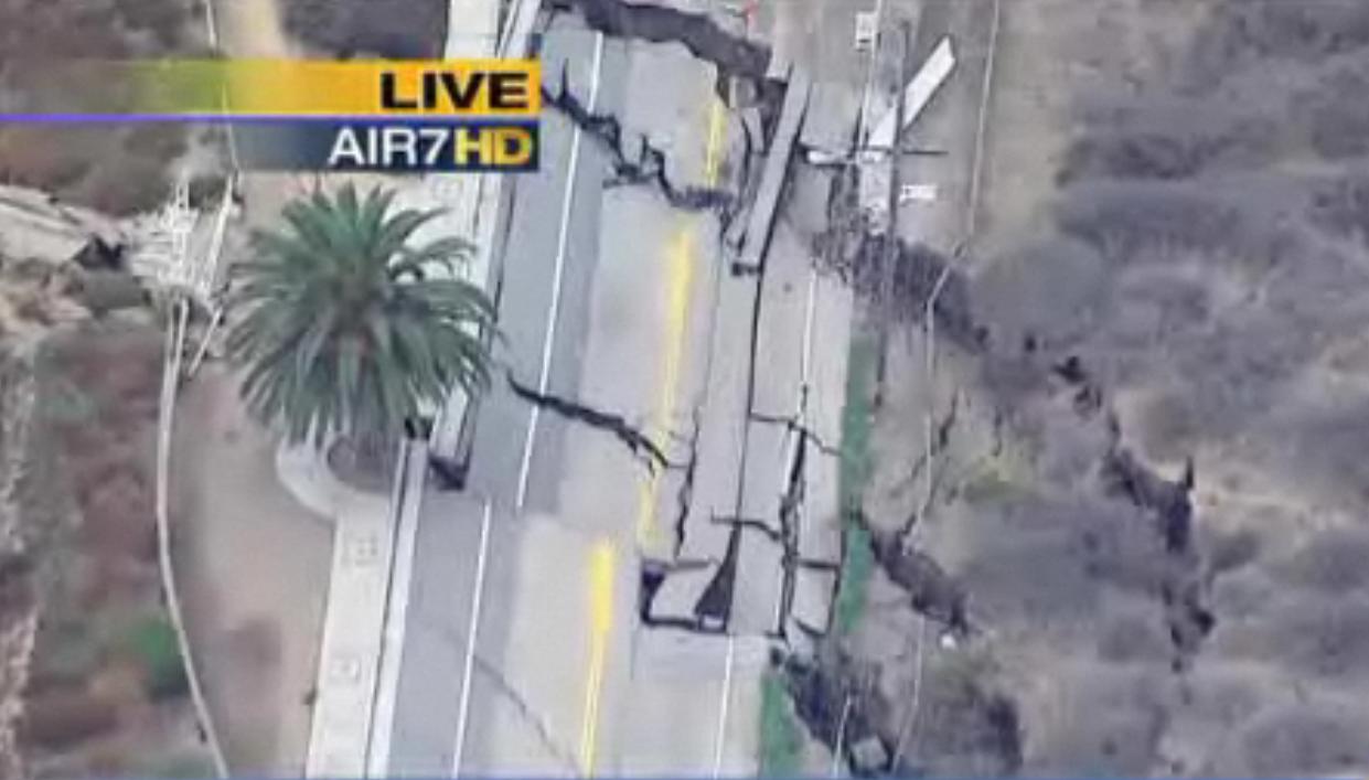
News today of an ongoing landslide affecting San Pedro in California. This slide, which has developed over the last few weeks, has closed the coast road. Real concern about the site emerged a couple of weeks ago; since then the problem has become far worse. At the moment I can’t find a decent still image of the site, but this still from this news report gives an idea of the magnitude of the problem (NB this is definitely not a sinkhole – it is a landslide):
Fortunately, it is only the road and utility lines that are threatened.
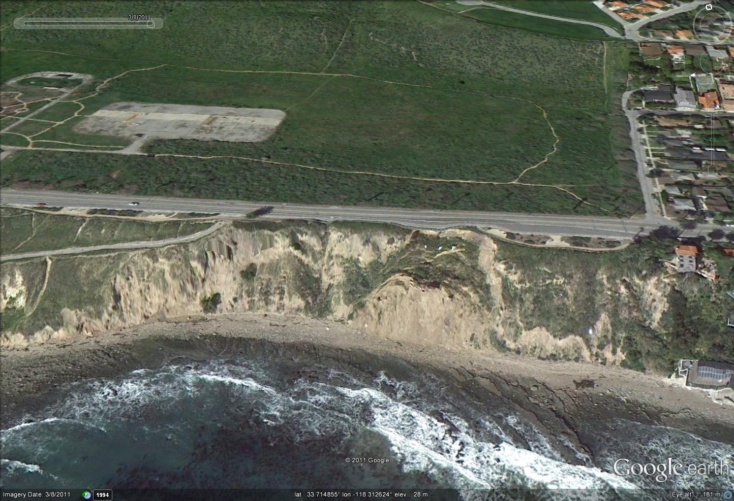
The site is well-covered by Google Earth imagery. This is the most recent perspective view from March this year:
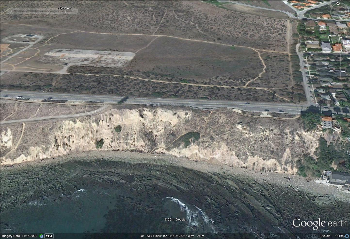
Compare that with an image from two years ago:
There has been a very noticeable loss of material on the right side(from this view) of the landslide, which shows the development of a progressive failure. I would anticipate that the loss of this buttress has destabilised the remainder of the slope. Thus, at least on first inspection, this just looks to be a natural failure caused by erosion by the sea. Where the road is so close to the cliff edge, and materials are weak, this is to be expected.
Repair of such a section would be very expensive and environmentally damaging as a large toe support will be needed, with a large volume of fill behind. Relocating the road inland looks to be the sensible option, if that is possible.
Any comments from those nearer the scene? Any better news reports?


 Dave Petley is the Vice-Chancellor of the University of Hull in the United Kingdom. His blog provides commentary and analysis of landslide events occurring worldwide, including the landslides themselves, latest research, and conferences and meetings.
Hi Dave,
I live a mile away from the landslide. Its located near some very historical sites including Pt. Fermin, Angels Gate Lighthouse and Historical Ft MacArthur. We are sad and amazed to see the continued erosion. Here are some additional pictures and news. http://on.fb.me/tZDjog http://bit.ly/w2Lth9 Best, Sheri
This area has been unstable as long as I can remember. (We moved to the LA area in the late 1960s.) I went across it a couple of months ago and they were actively working there. Six months before that not so much. Another well-known slide is above Pacific Coast Highway in Pacific Palisades. Its been stable for a long time now after major engineering work was done.
Here is another map-view of the site that you can zoom in on with more resolution. You can also spin around the site to get different view points (use the curved arrows in the upper right corner). Not sure when these images were taken but you can easily see the risk of the roadway being so close to the cliff.
http://www.bing.com/maps/?v=2&cp=pmk6xw546hyk&lvl=19.65389192077898&dir=349.6786744178754&sty=u&where1=San%20Pedro%2C%20CA&form=LMLTCC
Palos Verdes Estates has always been an interesting exploration area- especially the site of Portuguese Bend. Lots of interesting crystals, and a sectional study of earth movement towards the, and into the ocean. Something that is always working (creeping, sliding, dipping, and dropping).
At times manageable, but what escapes most people is that walking or crawling down to the beach level places them at extreme personal risk when ‘random probability’ causes some chunk of the landscape to fall and cover them up. True at the parks, and anywhere on the southern and SE facing shoreline. Anything east of San Pedro proper is risky, though slow to happen in normal creep; likely caused by a rift zone obscured by the ocean.
I used to go to the hot springs below the park, but even they have slid into the depths.
[…] site reminds me of some ongoing and recent landslides, such as the San Pedro slide in California (which appears to be accelerating), the recent cliff collapse in Wales, and this fatal cliff […]
Looks like it has finally gone:
http://www.bbc.co.uk/news/world-us-canada-15819302
[…] expected, the San Pedro landslide in California that I highlighted last week has now failed, with a substantial movement event that has caused complete destruction of the […]
Note the exposed bedrock in both photos. The curving beds dip gently seaward suggesting this slide is occurring along the axis of a seaward-plunging syncline. Tough fix, if any. At least there’s open ground inland that can be used for a bypass if needed.
Here are some new aerial photos taken by the Daily Breeze Helicopter. Last nights San Pedro Coastal Neighborhood Council meeting was attended by the City of Los Angeles Mayors office and Engineers who reported a firm has been hired to assess the slide and all services have been capped in the interim. If we get more rain there is a likely hood the land will keep shifting. As you can see from these pictures a huge chunk looks like it is about to break away.
oopps…here is the picture link : http://bit.ly/w2Lth9
[…] AGU – LANDSLIDE BLOG […]
[…] Roumelis has very kindly sent me an update on the San Pedro landslide, which (with his permission) I reproduce here: Approximate location is 33.715100°, […]