
11 November 2011
Drawdown landslides in muddy sediments at the Condit Dam
Posted by Dave Petley
Summary: The remarkable slope failures in the sediments at Lake Condit in Washington State USA, which were caught on video, illustrate the processes associated with slope failure during rapid draw-down.
One of the most intriguing landslide phenomena is that of drawdown instabilities in reservoirs and lakes. The idea is simple. When, for example, a new reservoir is built the changed water level in valley causes an increase in water level in the slopes. Sometimes, as in Vaiont, this can have unfortunate implications, and indeed it is these landslides that have caused so many problems on the banks of the Three Gorges reservoir in China. However, the real problems can start if the water level in the reservoir rapidly falls, which briefly leaves the high water levels in the slopes. This excess water then drains downslope through the soil and rock, generating an additional hydraulic force that acts to destabilise the slope. Finally, there may also be an effect of the loss of toe support that was provided by the water at the base of the reservoir bank, which may also act to destabilise the slope.
The upshot is that at least in theory rapid drawdown of a lake or reservoir can be bad news for the stability of the banks. For this reason, drawdown is usually undertaken slowly for very large reservoirs where instability is an issue. There are a few cases where rapid drawdown has been observed to cause major problems. Perhaps the best example is the Hattian Bala landslide lake in Pakistan, which was created in the 2005 Kashmir earthquake. The landslide dam breached catastrophically in early 2010, and the lake rapidly drained. The upshot was a series of landslides on the flanks of the lake that were highly destructive. The aftermath is caught rather nicely on this recent Google Earth image of the site:
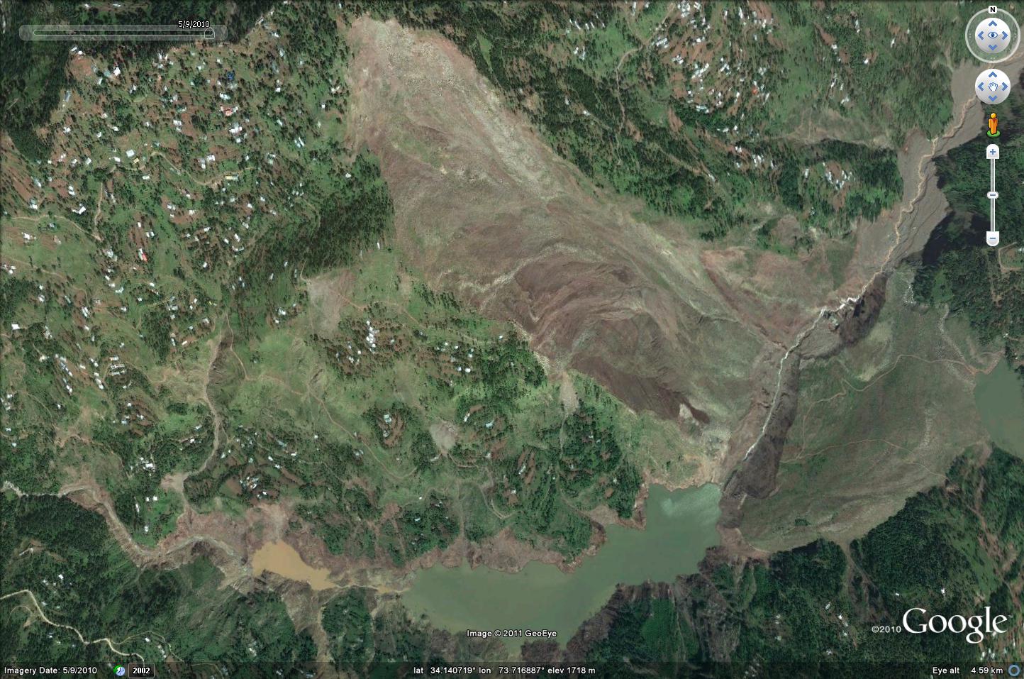
The landslide is the unvegetated mass in the upper centre of the image, with the remains of Karli Lake trapped behind the rump of the dam (visible at the bottom of the image). The slope failures along the banks can be seen with care, especially in the upper reaches of the old lake (near the rather muddy pool).
However, this process is quite poorly constrained and needs more research, though opportunities to do this are rare.
Interestingly, in the USA some old dams are now being removed for environmental reasons. This process is being undertaken with great care, and is in areas in which rapid drawdown is not likely to be a major a problem that is likely to affect the flanks for the lake. But, within these lakes vast volumes of sediments have accumulated that are in themselves prone to slope instability during rapid drawdown. The process is just the same as the above, but in this case the sediments are very weak and of course water saturated. The upshot is that they are inevitably unstable during drawdown, providing a perfect opportunity to examine this type of instability.
The Condit Dam in Washington state was breached explosively on 26th October 2011, resulting in rapid drawdown of the lake. The water level in the reservoir banks responded by falling, resulting in home owners noting that their wells have dried up. Interestingly though, a video was taken of the drop in water level, and response of the silt in the reservoir bed, after the lake level fell. This is a remarkable illustration of the landslide process in action:
The most interesting part of the video occurs from about 1 min 20 seconds into the video, when the recording is shown speeded up. As the lake level falls the muddy sediment in the banks slumps downwards – note how the process is episodic, not continuous, by the way. Towards the end a flow comes down the main channel in a series of pulses as well, and indeed this elevates the lake bed of the channel briefly.
This muddy material will be quite quickly eroded by the river once the main dam structure has been removed and some large flows come down the main channel. It is likely however that the homeowners will need to drill some deeper wells if they wish to get water from that source.
Finally, other dam removal projects are planned in the USA. There is a wonderful research opportunity if piezometers (instruments to measure water pressure) could be installed in the sediments (not a difficult task in itself), and a high-speed laser scanner were to be used to monitor the deformation of the materials as the lake level fell. This would generate a wonderful dataset that would greatly help in understanding slope failures in these types of materials and during rapid lake level changes.
As a footnote, can I say thanks to all those who pointed out this video to me. I am sorry that it has taken so long to put the post together!
 Dave Petley is the Vice-Chancellor of the University of Hull in the United Kingdom. His blog provides commentary and analysis of landslide events occurring worldwide, including the landslides themselves, latest research, and conferences and meetings.
[…] See blog post here. […]