
4 October 2022
The Beshbadam landslide in Kyrgyzstan
The Beshbadam landslide in Kyrgyzstan
Loyal reader Isakbek Torgoev has very kindly written to highlight the fascinating Beshbadam landslide in Kyrgyzstan. I had not been aware of this one – it is remarkable.
The slide was triggered by exceptional rainfall across Central Asia. Isakbek kindly provided a commentary about the event that I have used here.
The spring of 1969 was record-breaking in terms of the number of newly formed and activated old landslides in the Central Asian region. Over a vast area that includes mountain slopes, foothills and the valley part of the Fergana Valley, almost 2,000 landslides occurred in Kyrgyzstan and Uzbekistan alone, mainly in loess deposits that cover the slopes bordering the valley.
The main reason for the massive catastrophic activation of landslides, in the period from 10 to 13 March 1969, was the combination of intense melting of the anomalously thick snow cover with the peak of spring rains. The amount of atmospheric precipitation from November 1968 to May 1969 was more than double the long-term average. The winter of 1968-69 was also characterised by record snow accumulation, which exceeded the norm by 1.5 to 3.0 times, such that the height of snow cover in the foothills of the Fergana Valley at the end of February exceeded 140 cm.
This combination of an abnormally cold and wet winter with an abnormally wet spring has caused a huge number of new landslides throughout Central Asia. In fact, in the entire history of hydrometeorological observations, starting from 1913, such a combination of anomalous precipitation and temperature, both in the cold and in the spring period of 1969, has not been repeated.
The Beshbadam landslide is located at 41.145, 72.916. It is an absolute beauty. This is a Google Earth perspective of the landslide:-
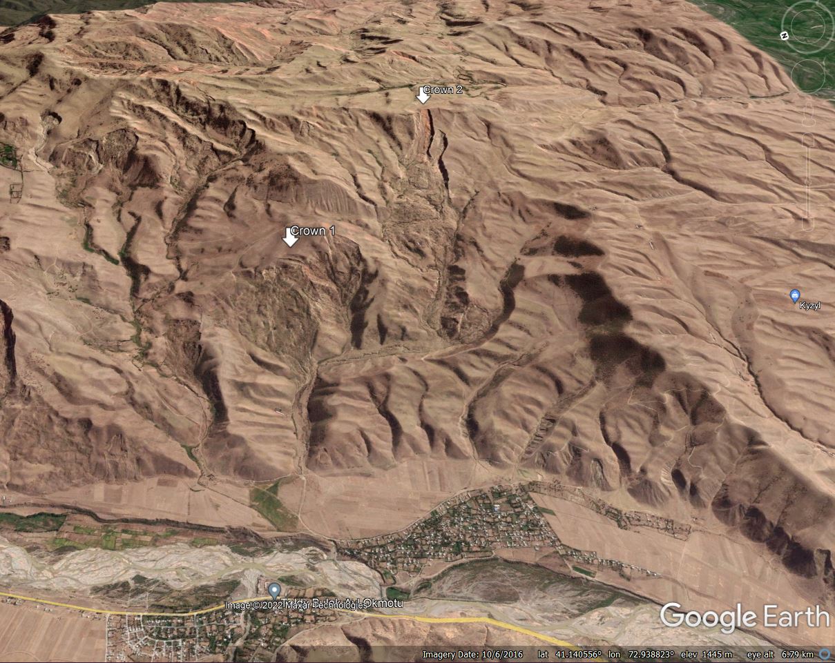
Google Earth perspective view of the Beshbadam landslide in Kyrgyzstan.
.
This is a very large, complex landslide. There are two main components, on the left side of the image is a large failure covering two sub-catchments. I have marked the head of this landslide as Crown 1. Isakbek has informed me that this landslide in 1.5 km long and 650 m wide at the head. To the right is another, much longer failure extending to the ridge, which I have marked as Crown 2. This component is 4.4 km long. The total volume of the landslide is about 5 million cubic metres, with a depth of 40 metres.
Isakbek has very kindly provided a historic photograph of the landslide:-
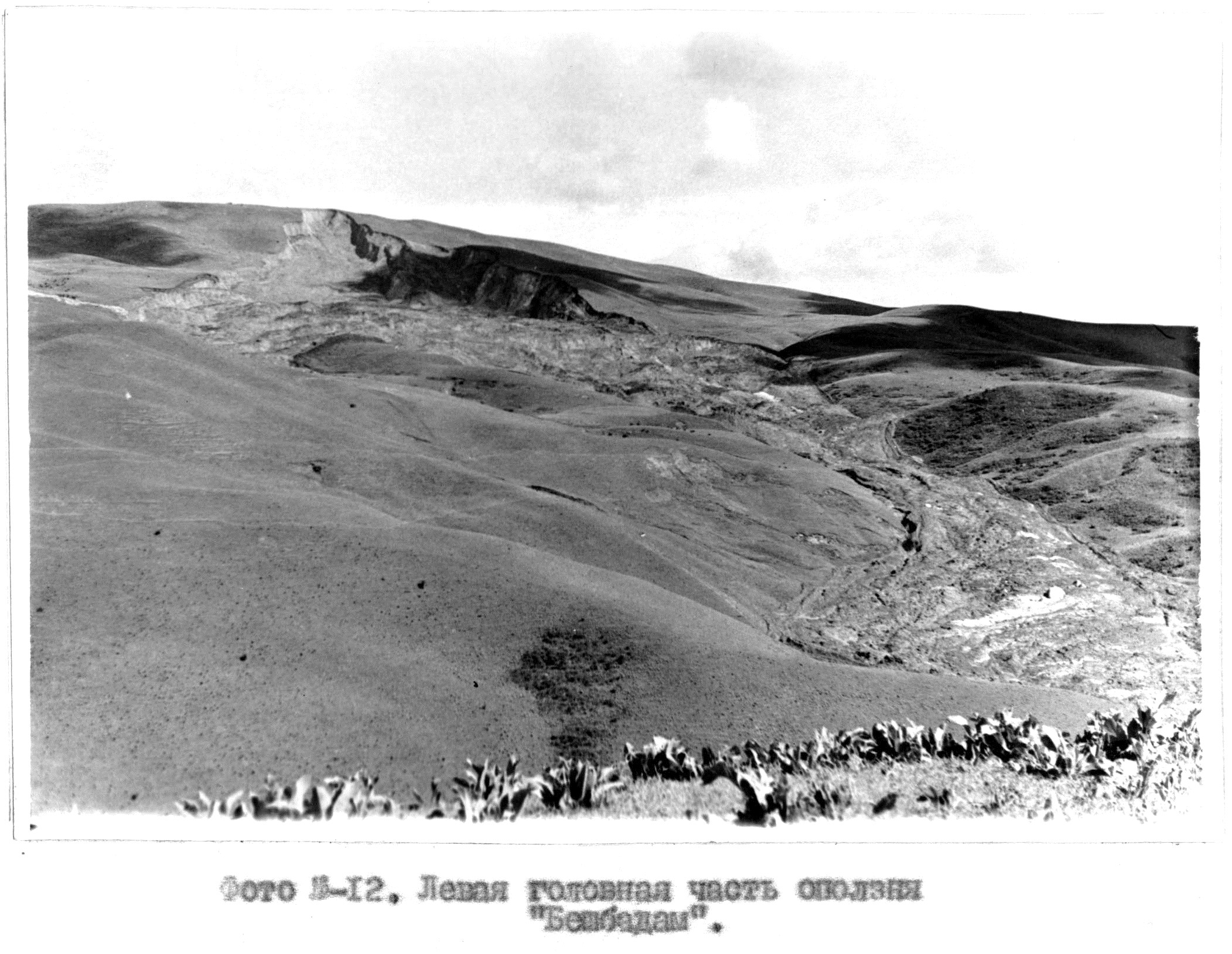
Historic photograph of the Beshbadam landslide in Kyrgyzstan. Image provided by Isakbek Torgoev.
.
This is (I think) the Crown 2 component of the Beshbadam landslide, which has developed substantially since.
The landslide reminds me a little of the remarkable Slumgullion landslide in Colorado, USA. It would be interesting to know if the Beshbadam landslide shows similar movement patterns.
The Google Earth image shows other landslides in this area, and as Isakbek noted there are many other substantial landslides in the region. These have probably not received the attention they deserve from the wider landslide community, although the Asian Development Bank is currently funding a programme focusing on landslide risk management in Kyrgyzstan.
3 October 2022
Shuiliandong: an example of a landslide triggered by underground coal mining
Shuiliandong: an example of a landslide triggered by underground coal mining
I’ve written extensively about landslides triggered by mining activities, including failures in mine waste (most notably tailings dam collapses) and failures in rock slopes. I’ve written rather less about surface landslides triggered by subsidence from subterranean mining, even though this can be a substantial problem. In a paper published in the journal Landslides (Ma et al. 2022), such an example is featured, associated with deep coal mining at Shuiliandong, located in Shaanxi Province in China. Infuriatingly, the paper provides little detail on the actual location (this happens repeatedly), but I have tracked it down. The mine itself is located at 35.049, 108.032.
The mine, which is still active, extracts about 1.35 million tonnes of coal per year from a seam about 340 m below the surface. Ma et al. (2022) report that it has triggered extensive subsidence, including large fissures. A village located above the mine workings has been so badly damaged that it has been forced to relocate.
The authors highlight one landslide in particular, located 35.052, 107.997. The image below, from Google Earth, shows the landslide shortly after failure – the image was collected in 2015:-
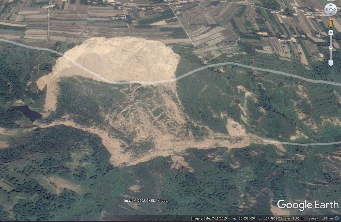
The mining-induced landslide close to Shuiliandong in China. Google Earth image collected in 2015.
.
This is a large failure – 529 m long and 504 m wide according to Ma et al. (2022), with an average depth of about 37 m. Note the toe of the landslide extending down the valley. The volume is about 3 million cubic metres.
Ma et al. (2022) have simulated the formation of this landslide. The suggest that the failure was preceded by extensive ground fissuring as the subsidence bowl developed. This led to extensive fracturing at the toe of the slope, which in turn initiated failure. They also suggest that the fissuring and ground deformation may have created preferential pathways for the passage of water through the ground, allowing failure to develop.
It is notable that the image above shows other areas of deformation in the slope, indicating the mining-induced slope instability may continue to be a problem at Shuiliandong.
The capacity for deep mining to trigger slope instability has been known for well over a century – examples from South Wales are well documented for example. That such disruption can occur now is disappointing.
Reference
Ma, S., Qiu, H., Yang, D. et al. 2022. Surface multi-hazard effect of underground coal mining. Landslides. https://doi.org/10.1007/s10346-022-01961-0
30 September 2022
Landslides in the 1960s
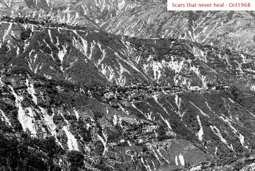
Landslides triggered by the October 1968 rainstorms in Darjeeling, India. Image from the Save the Hills blog, Image by Das Studio.
Landslides in the 1960s
As I was writing my blog post earlier this week about the 1961 Kurenivka mudslide in Ukraine, I was pondering the number of large landslide disasters that occurred in the 1960s. Based on no scientific analysis at all, it seems that this was a period of remarkable landslide accidents. So, I decided that it would be interesting to begin the process of putting together a list. This is what I have come up with so far:
- The M=9.4 22 May 1960 Valdivia Earthquake in Chile, the most powerful seismic event in instrumented history, which triggered huge numbers of landslides, including the valley blocking landslide at Riñihuazo.
- The 3 February 1961 Jupille landslide in Belgium, a fly ash failure that killed 11 people.
- The 13 March 1961 Kurenivka mudslide in Ukraine, which killed about 1,500 people
- The 10 January 1962 Huascarán landslide, in which 13 million cubic metres of rock and ice detached from Nevados Huascarán in Peru, killing an estimated 4,000 people. This was followed by a second, larger, event in 1970.
- The 9 October 1963 Vajont landslide, in which a 260 million cubic metre failure on the flanks of Mount Toc sent a huge wave over the crest of the Vajont dam, killing 1,917 people.
- The M=9.2 27 March 1964 Great Alaskan Earthquake, which triggered a large number of landslides. In the city of Valdez, 32 people were killed by a landslide that caused the collapse of the harbour and docks. In the Turnagan neighbourhood, 75 houses were destroyed by landslides.
- The 9 January 1965 Hope Landslide in Canada, which has an estimated volume of 47 million cubic metres. The remote location meant that only four people were killed.
- The 28 March 1965 El Cobre tailings dam failure in Chile, which killed over 200 people.
- The 2 January 1966 Rio de Janeiro landslides in Brazil, which killed at least 114 people. Some reports indicate that the final toll may have been about 250 people. The USGS suggests it may have been about 1,000 people.
- The 21 October 1966 Aberfan landslide in Wales, in which 144 people, the majority of whom were children, were killed by the failure of a coal waste tip.
- The 22-23 January 1967 Rio de Janeiro and Serra Das Araras landslides, which the USGS estimates killed 1,700 people.
- The 20 March 1967 landslides at Caraguatatuba in Brazil, which killed 120 people.
- The October 1968 Darjeeling landslides. It is estimated that heavy rainfall triggered over 20,000 landslides, killing thousands of people.
- The 17 August 1968 debris flow at Hida in Japan, win which two buses were lost, killing 104 people.
I am sure that there are many more disasters in the 1960s – please let me know what I have missed. Notable in the above list is the series of landslides that were caused by earthquakes, including the huge events in Chile and Alaska, and landslides caused by technological failures (including Kurenivka, Jupille, Vajont, El Cobre and Aberfan). These series of events through the decade were instrumental in the scientific work in the following decades that has led to our current understanding of landslides.
29 September 2022
The causes of the 3 January 2022 landslide at Bijie City in Guizhou Province, China
The causes of the 3 January 2022 landslide at Bijie City in Guizhou Province, China
On 3 January 2022 a major landslide occurred in the Jinhaihu District of Bijie City in Guizhou Province, China. The landslide, which occurred at a construction site, killed 14 people, whilst a further three people were injured. The causes of this landslide have been reviewed in a paper (Tao et al. 2022) published in the journal Landslides.
The location of the landslide is 27.233, 105.463. The site, which was excavated to allow construction of a training facility for Bijie First People’s Hospital, consisted of a slope that was cut to create three benches. The image below, from the paper, provides a drone overview of the aftermath of the landslide:-
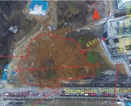
The aftermath of the landslide 3 January 2022 landslide at Bijie in China. Image from Tao et al. (2022).
.
The topography of the slope was not steep – just 15 degrees. On the day of the landslide, 18 mm of rainfall fell, although there had been some snowfall and melt in late December that may have contributed to the groundwater level. It appears that it was high pore water pressures that triggered the failure.
The underlying cause of the landslide was the geological setting. The site was a dip slope, in which there was a weak geological layer orientated sub-parallel (at 13 degrees) to the topographic slope. The strata consisted of intensely weathered mudstones sitting over weak sandstones. Excavation of the slope exposed a thin (3 cm), particularly weak layer in the underlying sandstones, creating a free face that allowed sliding. Joints towards the crown of the slope provided further weakness and allowed infiltration of water.
The slope has undergone a smaller failure in October 2021, but construction continued. The landslide of 3 January 2022 had a volume of 35,000 cubic metres, a length of 77 m and a thickness of up to 8 m. The debris moved about 30 m. Failure occurred over about 15 seconds.
Tao et al. (2022) appear to have been careful not to ascribe blame for the landslide, but the event asks some interesting questions for me:
- Did the ground investigation identify the existence of the dip slope condition and the presence of the weak interlayer?
- Did the design recognise the potential for failure, and if so how was this to be managed?
- Given the 20,000 cubic metre failure in October 2021, was there a reconsideration of the geological setting of the site, and was the design or construction plan changed?
- Was there monitoring at the site? If not, why not? Were there any signs of the development of instability prior to the failure?
This is a really interesting example of a failure triggered during construction. One aim of site investigation and detailed design is to avoid the devastating consequences of a failure of this type. The landslide at Bijie city is a great case study that illustrate what happens when this does not go to plan.
.
Reference
Tao, T., Shi, W., Liang, F. et al. 2022. Failure mechanism and evolution of the Jinhaihu landslide in Bijie City, China, on January 3, 2022. Landslides. https://doi.org/10.1007/s10346-022-01957-w
28 September 2022
The 1961 Kurenivka mudslide in Ukraine
The 1961 Kurenivka mudslide in Ukraine
On 13 March 1961 a very large landslide occurred in Kurenivka area of the city of Kyiv (Kiev) in Ukraine, although at the time it was a part of the Soviet Union. The location is 50.486, 30.473, although there is little evidence of the landslide now. The event is now known as the Kurenivka mudslide (or the Kyrenivka mudslide in some cases).
The landslide was the consequence of a strange and tragic set of circumstances. In September 1941, the Babyn Yar ravine at the top of the slope was the site of a Nazi atrocity in which 34,000 Jewish people were murdered. The site continued to be the location of the murder of Jewish and other people through the Nazi occupation; it is estimated that 100,000 people were killed there.
Upon recapture of the city, the Soviet authorities sought literally to cover up the tragedy by burying the site beneath a landfill. Subsequently, the ravine was filled with dense liquid waste from brick factories in the area.
Radio Free Europe has a good account of the events of 13 March 1961. The previous evening the pumping station at the dam that was retaining the waste failed. At 8:30 am the dam collapsed, releasing at least 600,000 cubic metres of waste (some reports indicate 4 million cubic metres), including brickworks waste, mud, water and (dreadfully) human remains. It is reported that landslide debris cascaded through the streets of Kurenivka for about two hours. The Wikipedia account describes the burial of “a residential area, a tram depot, several industrial buildings and a cemetery, as well as traffic moving along the streets”.
The impact was devastating. At least 50 people were killed at the tram depot alone. The official toll is 145 people, but some investigations have suggested that 1,500 people lost their lives that morning.
Included in the Radio Free article about the Kurenivka mudslide are some archive images of the aftermath of the disaster. This pair of images provides an interesting view of the scale of the event:-
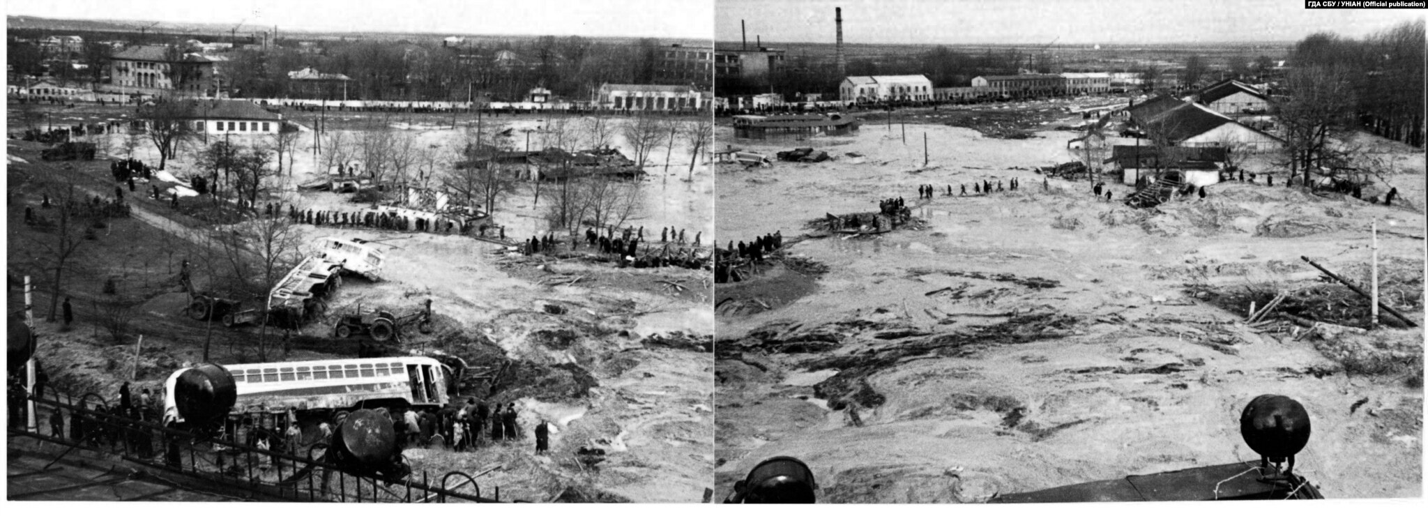
The aftermath of the 13 March 1961 Kurenivka mudslide in Ukraine. Image from Radio Free Europe.
.
In the aftermath of the landslide, the site was cordoned off by the Soviet authorities, and information about the disaster was suppressed. It appears that there was an attempt to pin the blame of the chair of the City Council, Alexei Iosifovich Davydov. He died in mysterious circumstances on 20 October 1965; the official version is that he committed suicide, although this is disputed.
The amount of detail available about the Kurenivka mudslide remains limited, and I suspect that there is little knowledge of this tragic event in the landslide community. It is a disaster that is worthy of further, detailed study amidst the ongoing tragedy in Ukraine.
26 September 2022
High resolution satellite imagery of the Jagersfontein tailings dam failure
High resolution satellite imagery of the Jagersfontein tailings dam failure
Planet Labs has released a high resolution (SkySat) image of the Jagersfontein tailings dam failure:-
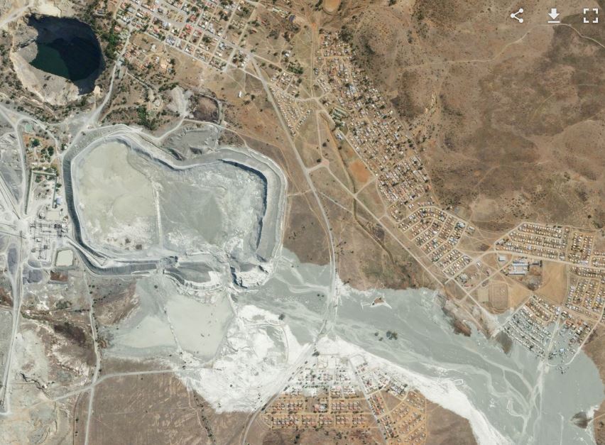
Planet Labs SkySat image of the 11 September 2022 Jagersfontein tailings dam failure. Image copyright Planet Labs, released under a Creative Commons licence.
.
As always the image is beautiful (although the subject is grim), showing the major breach on the eastern end of the southern edge of facility, plus the other locations of major erosion (which remain unexplained). Note also the inundated houses.
Meanwhile the New York Times has a detailed and excellent article about the breach. Interestingly, it reports that a crack was spotted in the facility at 2 am on the day of the collapse:-
At about 2 a.m. on Sunday, Sept. 11, a truck driver at the dam spotted a crack in the facade, several workers there that day said in interviews. The driver reported it to a foreman, who checked it out but did not do anything, the workers said.
Joe Makalajane, a pan operator at the mine, did not see the crack himself but spoke to the driver as they were ending their shift, he said.
“He said, ‘I’ll tell you, that thing is going to blast,’” said Mr. Makalajane, 45, recalling his conversation. Of management, he added, “They didn’t take it seriously.”
It has been widely reported that the Jagersfontein tailings dam was owned by Stargems, and indeed there are quotes online from the company about the facility. It is remarkable though that the news section of the their website appears to lack any information about the failure.
Previous tailings dam failures have been investigated by independent teams, with the outcomes being published openly. An example is the Córrego do Feijão tailings dam failure at Brumandinho in Brazil. I have still to see a commitment to a similar level of transparency in the case of the Jagersfontein tailing dam failure. Interestingly, the summary of the meeting of the South African government cabinet in which the disaster was considered makes no reference to an independent investigation. Does anyone have any more information?
.
Acknowledgement
Planet Team (2022). Planet Application Program Interface: In Space for Life on Earth. San Francisco, CA. https://www.planet.com/
23 September 2022
The 17 September 2022 rock avalanche at Lamplugh Glacier in Alaska
The 17 September 2022 rock avalanche at Lamplugh Glacier in Alaska
It has been a busy few days for rock avalanches in North America. Hot on the heels of the massive landslide at Ecstall River in British Columbia in Canada comes news of another. This event was detected by Matt Haney of the Alaska Volcano Observatory using seismometer data, and quickly narrowed down to a site on Lamplugh Glacier. Dan Shugar (@WaterSHEDLab) of the University of Calgary has tweeted the details – once again do read the full set of tweets to understand this one in detail:-
https://twitter.com/WaterSHEDLab/status/1572202447032188928
.
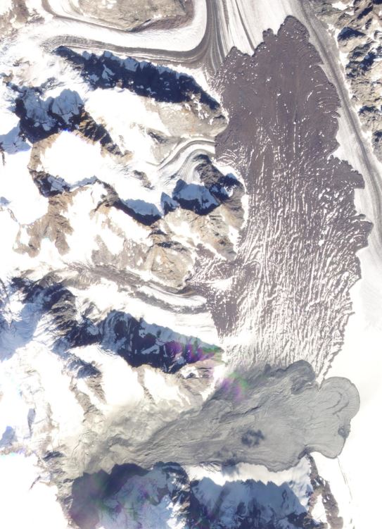
Planet Labs captured a beautiful image of the site on 18 September 2022, the day after the failure:-
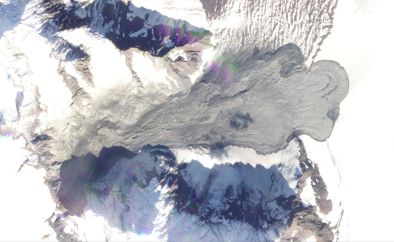
Satellite image of the 17 September 2022 rock avalanche at Lamplugh Glacier, collected on 18 September 2022. Image copyright Planet Labs, used with permission.
.
The rock avalanche has a runout distance of about 6 km by my initial calculation. Unlike the landslide at Ecstall River it has not been channelised, and in this case it has run out across ice. Thus, the deposit has a very different morphology. The flow structures at the tow are beautiful, illustrating the spreading of the landslide in the late (low velocity) stage of movement:-
Satellite image of the toe of the 17 September 2022 rock avalanche at Lamplugh Glacier, collected on 18 September 2022. Image copyright Planet Labs, used with permission.
.
As Dan has pointed out in his tweets, this rock avalanche has in part travelled across the deposit of the even larger 23 June 2016 rock avalanche at the same site (although a different section of the slope collapsed to generate that one). The relationship between the two landslides is captured on the Planet Labs imagery:-
Satellite image of the two rock avalanche deposits at Lamplugh Glacier, collected on 18 September 2022. Image copyright Planet Labs, used with permission.
.
Once again the team that identified this enormous landslide will, I’m sure, produce a detailed analysis of it in due course. I shall look forward to seeing that publication.
.
Acknowledgements
The project team outlined above have rapidly undertaken an analysis of this event and have posted the information online. Thanks to them for doing so. The images are from the wonderful people at Planet Labs.
Planet Team (2022). Planet Application Program Interface: In Space for Life on Earth. San Francisco, CA. https://www.planet.com/
21 September 2022
The 1 September 2022 rock avalanche on the Ecstall River in British Columbia, Canada
The 1 September 2022 rock avalanche on the Ecstall River in British Columbia, Canada
On 1 September 2022 a large rock avalanche occurred on the Ecstall River in British Columbia, Canada. This event was identified by Göran Ekström at Columbia University from seismic data, and has then been tracked down and documented by a multidisciplinary team that includes Brian Menounos and Marten Geertsem from UNBC, and scientists from the BC Government and the Hakai Institute. The event is well described in a series of tweets by Brian Menounos (@brianmenounos):-
On 1 Sept, @lamontdoherty Göran Ekström detected a seismic event north of Kitimat which turned out to be an ice/rock avalanche on the Ecstall River that slammed into a lake and created a downstream flood similar to the event at Elliot Creek. pic.twitter.com/7mf54wilqY
— Brian (@brianmenounos) September 18, 2022
.
It is worth looking at the full set of tweets to get an understanding of this event and of the work of the team.
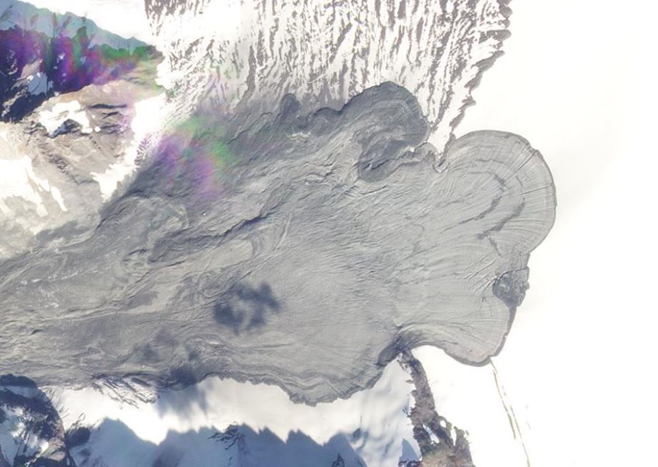
On first inspection the landslide appears to have started as a failure on a near-vertical rockface, and then to have transitioned into a classic ice/rock avalanche. The source of the landslide is at about 53.965, 129.323. This is a Planet Labs image of the site before the landslide:-
Satellite image of the site of the rock avalanche on the Ecstall River in BC, collected on 1 August 2022. Image copyright Planet Labs, used with permission.
.
And this is the site afterwards:-
Satellite image of the rock avalanche on the Ecstall River in BC, collected on 20 September 2022. Image copyright Planet Labs, used with permission.
.
This is a very large landslide with a long runout. I have tried to set up a juxtapose below to allow you to compare the two images:-
.
.
Am additional point of interest here is the image of 1 September 2022, the day of the landslide. The image itself is clear, except in the valley affected by the landslide. Is this the remains of the dust cloud?
Satellite image of the rock avalanche on the Ecstall River in BC, collected on 1 September 2022. Image copyright Planet Labs, used with permission.
.
Whilst this landslide is in a remote location, it is causing concern about the potential impact on salmon spawning grounds. Global News has an article providing some detail.
The team involved in the research into this landslide are world leading, so no doubt we will see a full description and analysis of it in due course. It is a fascinating event.
.
Acknowledgements
The project team outlined above have rapidly undertaken an analysis of this event and have posted the data online. Thanks to them for doing so. The images are from the wonderful people at Planet Labs.
Planet Team (2022). Planet Application Program Interface: In Space for Life on Earth. San Francisco, CA. https://www.planet.com/
20 September 2022
Save the Hills: a documentary about the impact of a landslide on Tanyang village
Save the Hills: a documentary about the impact of a landslide on Tanyang village
Save the Hills is a wonderful NGO that raises awareness and helps in the management and mitigation of landslides in the Darjeeling-Sikkim area of northern India. It runs an excellent blog – probably the best example of a community awareness raising of which I’m aware. I’ve been fortunate to visit once, but would love to go back.
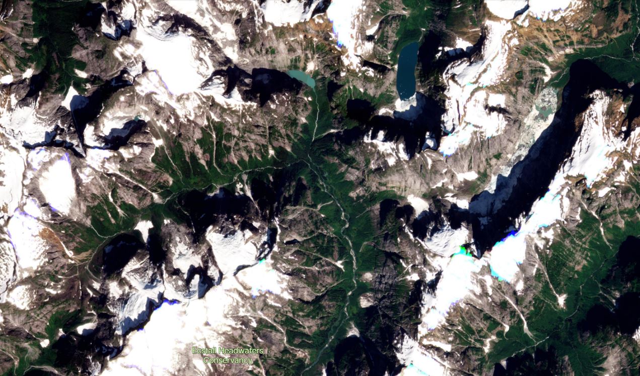
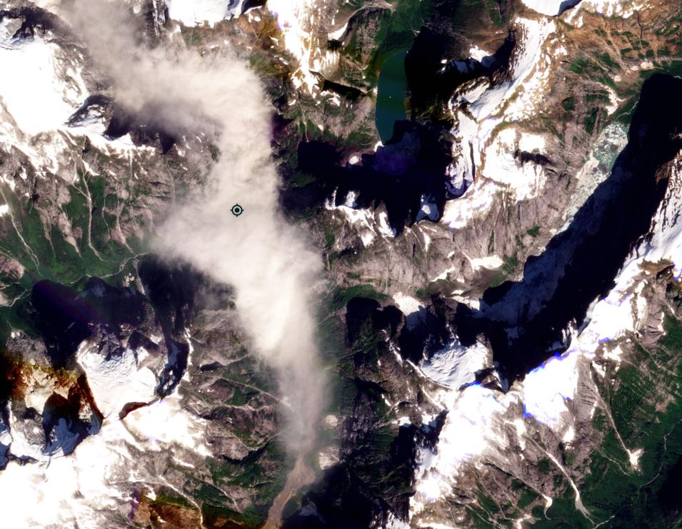
One of their current projects focuses on Tanyang, a remote village two hours from Kalimpong. The village is located at 27.006, 88.494. Tanyang is being affected by a major landslide that is removing land at a prodigious rate, threatening the livelihood and wellboing of the population. This is the site as viewed on Google Earth, with the landslide clearly visible:-
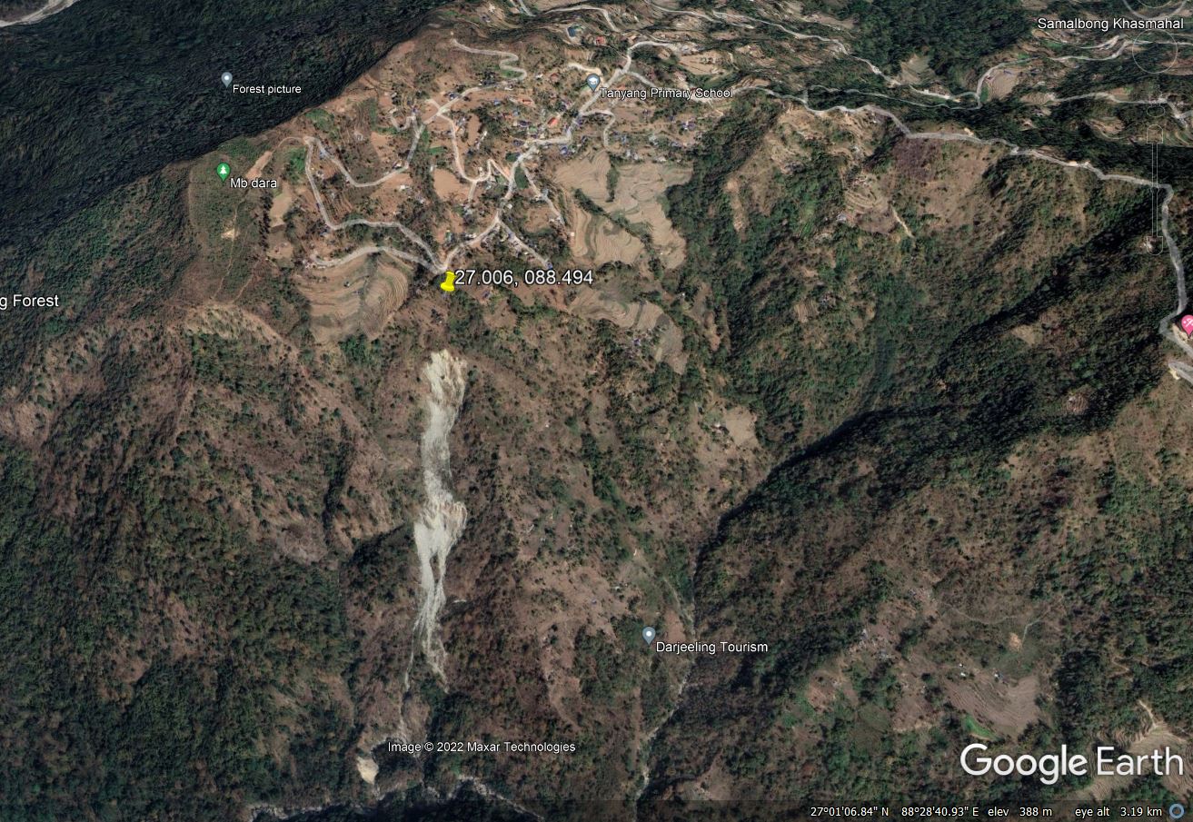
The landslide at Tanyang in northern India, as seen on Google Earth. Image dated March 2022.
.
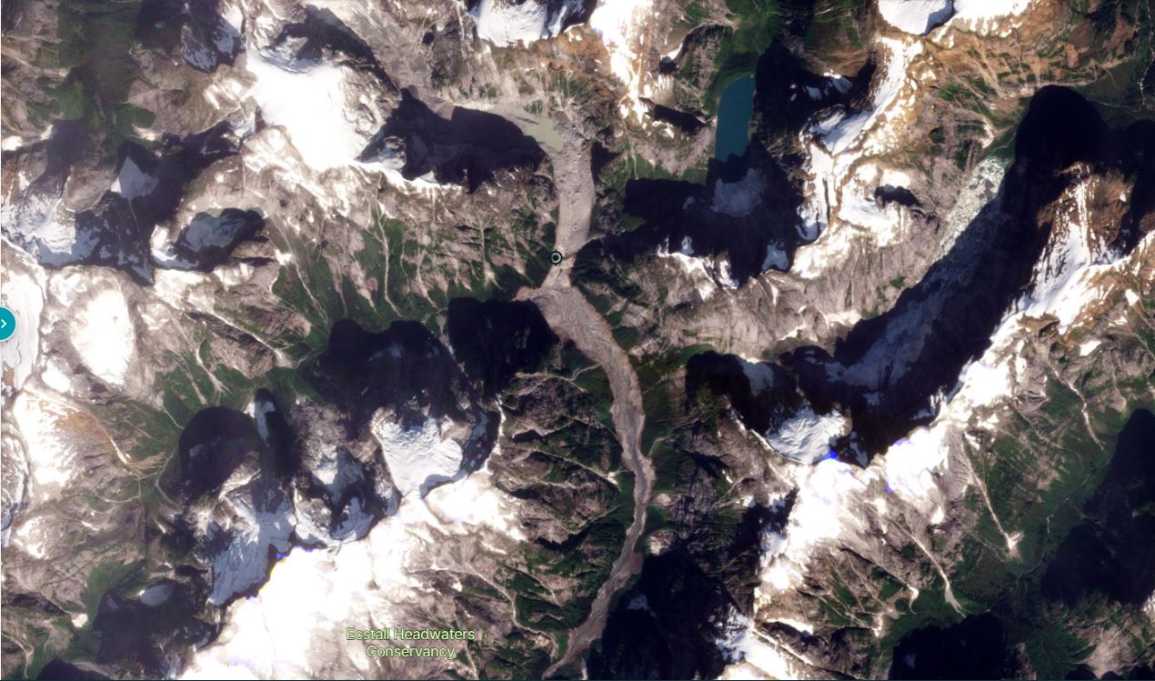
The terrible rate at which this landslide is removing land is evident from earlier Google Earth images. The view below is from January 2010 – the change in the landslide over 12 years is dramatic:-
The village of Tanyang in northern India, as seen on Google Earth in January 2010.
.
Save the Hills has posted a short article about the landslide, suggesting that major movement was initiated by the September 2011 earthquake. There are signs of instability at the site prior to this, but the Google Earth imagery does show a major change in the slope at around this time.
The team at Save the Hills has compiled an excellent video about this landslide and, importantly, its impact on the local people. This video has been posted to Youtube:-
https://drive.google.com/file/d/1yF5RJJvnUrLcGmqGhbCW6iNFwuu9yrY0/view.
Hopefully you’ll be able to view the embedded video above. I think that this is a really excellent piece of work, showing the dramatic impact of an event such as this on the local population. As the video highlights, the greatest asset that these people possess is the land on which they live. The landslide is stripping that from them, and displacing them from their homes to live in small tin sheds.
This pattern is repeated in many locations. There is rarely any substantial level of relief for the affected people.
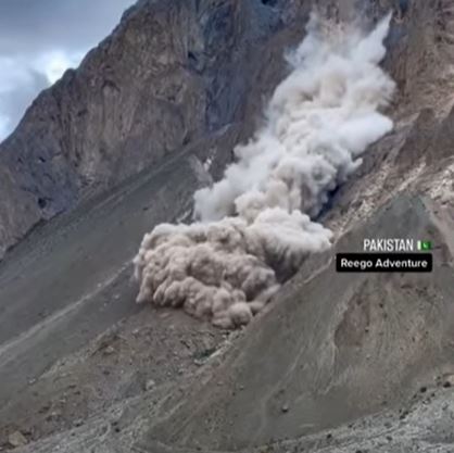
16 September 2022
A dramatic rockslide video from K2
A dramatic rockslide video from K2
A video has been posted to Youtube that shows a rockslide occurring on the flanks of K2 in Pakistan:-
.
There is little detail about this landslide – the video was reportedly collected close to the Baltoro Glacier. It was posted on 13 September 2022.
It appears that the event initiated on a near vertical rockface:-
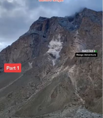
The early stages of the rockslide in Pakistan. Still from a video posted to Youtube.
.
The terrain below is steep and mantled with debris, so the event transitioned into a rockslide or avalanche:-
The runout stage of the rockslide on the flanks of K2 in Pakistan. Still from a video posted to Youtube.
.
Fortunately it is reported that there was no-one in the path of the landslide.
 Dave Petley is the Vice-Chancellor of the University of Hull in the United Kingdom. His blog provides commentary and analysis of landslide events occurring worldwide, including the landslides themselves, latest research, and conferences and meetings.
Recent Comments