
15 September 2022
Provisional InSAR data for the Jagersfontein Tailings Storage Facility failure
Provisional InSAR data for the Jagersfontein Tailings Storage Facility failure
The fallout from the failure of the Jagersfontien Tailings Storage Facility (TSF) continues to develop, with increasing levels of interest in the owners, Jagersfontein Developments, and their political connections. Interestingly, In February 2021 the mayor of Kopanong Local Municipality Xolani Stalin-Tseletsele posted concerns about the facility on Facebook. He stated that: “If that dam breaks loose, the muddy water will ruin lives, cause deaths and damage the community”. Prescient words indeed.
Meanwhile, once again this failure has sent a warning more widely about the danger posed by large tailings facilities. I wonder if high energy costs are leading to a reduction in maintenance and monitoring of these facilities, with a resultant potential for failure.
Meanwhile, independent analyses of failure are being undertaken by the science community. My friends at CGG Minerals and Mining, a data and analytics company with high levels of expertise in the use of InSAR analysis, have been quickly out of the blocks. I’m posting the below with their permission, but you can see their original analysis on LinkedIn.
They have posted a high resolution satellite image of the aftermath of the failure, annotated with the key features:-
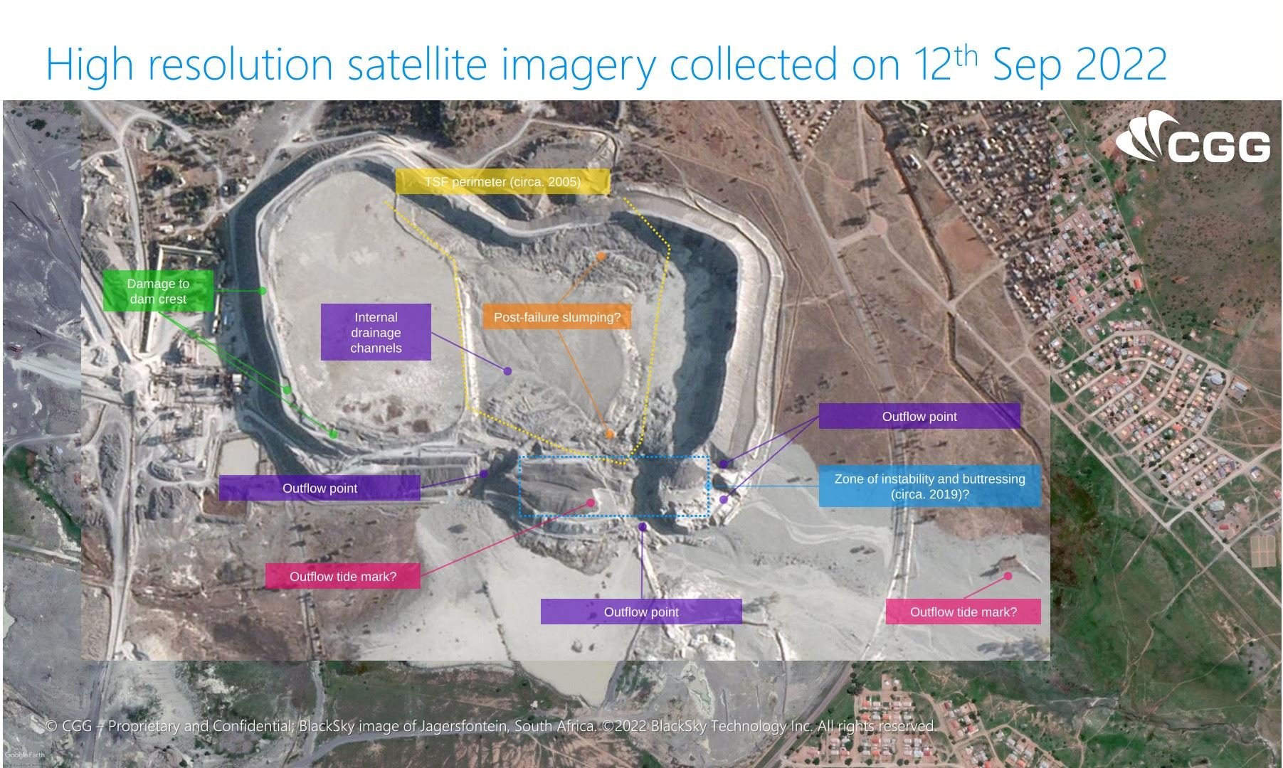
A high resolution satellite image of the aftermath of the Jagersfontein Tailings Storage Facility failure. Image processed by CGG Minerals and Mining, used with permission.
.
The image highlights key features that I identified earlier this week, including the main breach with the three other locations of substantial erosion. It is interesting that they have also identified damage to the dam crest on the west side of the TSF. Of greater potential significance is a provisional InSAR analysis that they have undertaken for deformation between 1 and 13 August 2022:-
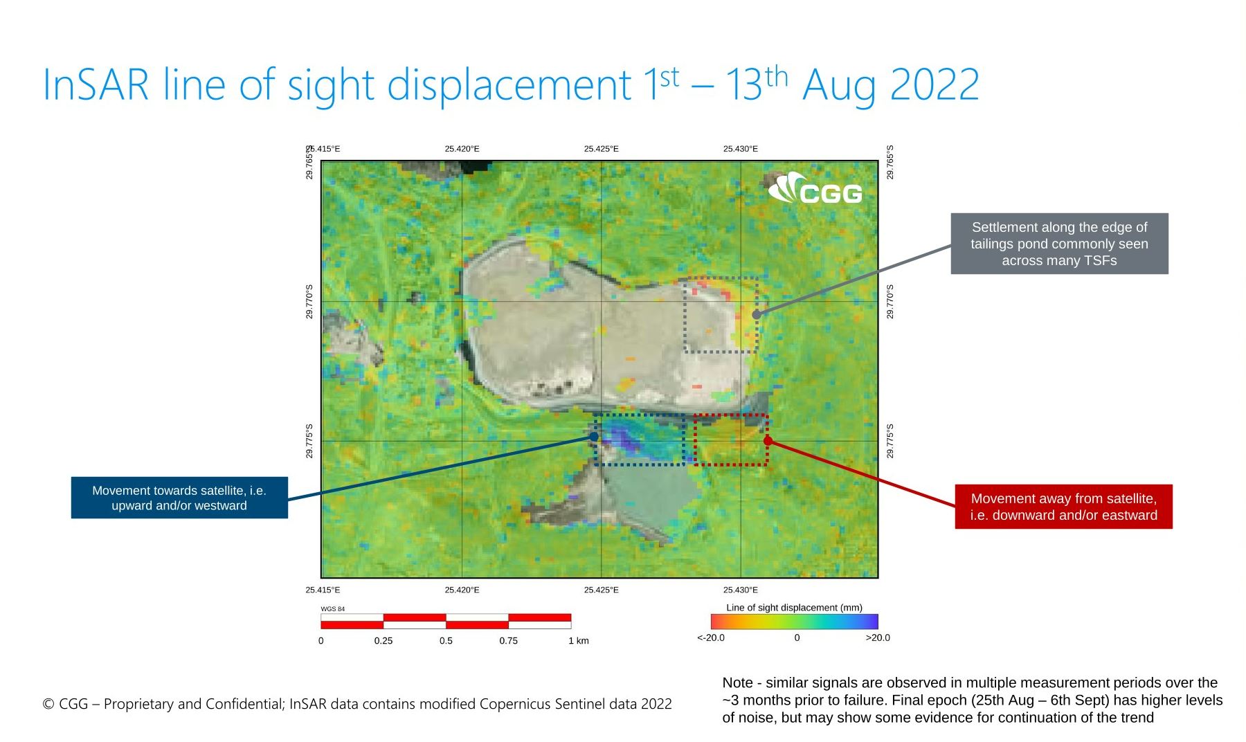
InSAR analysis of pre-failure deformation at the Jagersfontein Tailings Storage Facility. Image processed by CGG Minerals and Mining, used with permission.
.
CGG Minerals and Mining have provided their own interpretation of the data:-
CGG Minerals and Mining interpretation of their analysis of the Jagersfontein Tailings Storage Facility failure. Copyright CGG Minerals and Mining, used with permission.
.
The key element here is that deformation was observed in this image pair, and in others, in the walls at the southeast side of the TSF. The element that I find most interesting is that a part of this section was showing movement away from the satellite, whist another section was showing movement towards it. The junction between the two is close to the apparent failure point.
These types of analyses are very provisional at this stage, but may point to deformation of the TSF walls that led to failure.
As always, a forensic analysis of the events of Jagersfontein by an independent team of experts is needed urgently. Mining Weekly has reported that “investigations are under way with the appointment of a task team to determine the cause of the incident and the extent of the damage”. At present there is little further detail that I can find.
.
Acknowledgement
Many thanks to my friends at CGG Minerals and Mining for the analysis highlighted here and for their willingness for me to post their results.
14 September 2022
The Jagersfontein tailings dam accident: the aftermath
The Jagersfontein tailings dam accident: the aftermath
Inevitably, there is considerable discussion about the Jagersfontein tailings dam failure as the impacts become more clear. The slimes released into the channel have travelled downstream to the reservoir behind the Kalkfontein Dam. The Planet Labs images below show the reservoir on 8 September 2022, before the slimes reached the lake, and 12 September 2022, afterwards. The impacts of the pollution event are clear:-
Satellite image of the Kalkfontein Reservoir, collected on 8 September 2022, before the Jagersfontein tailings dam accident. Image copyright Planet Labs, used with permission.
.
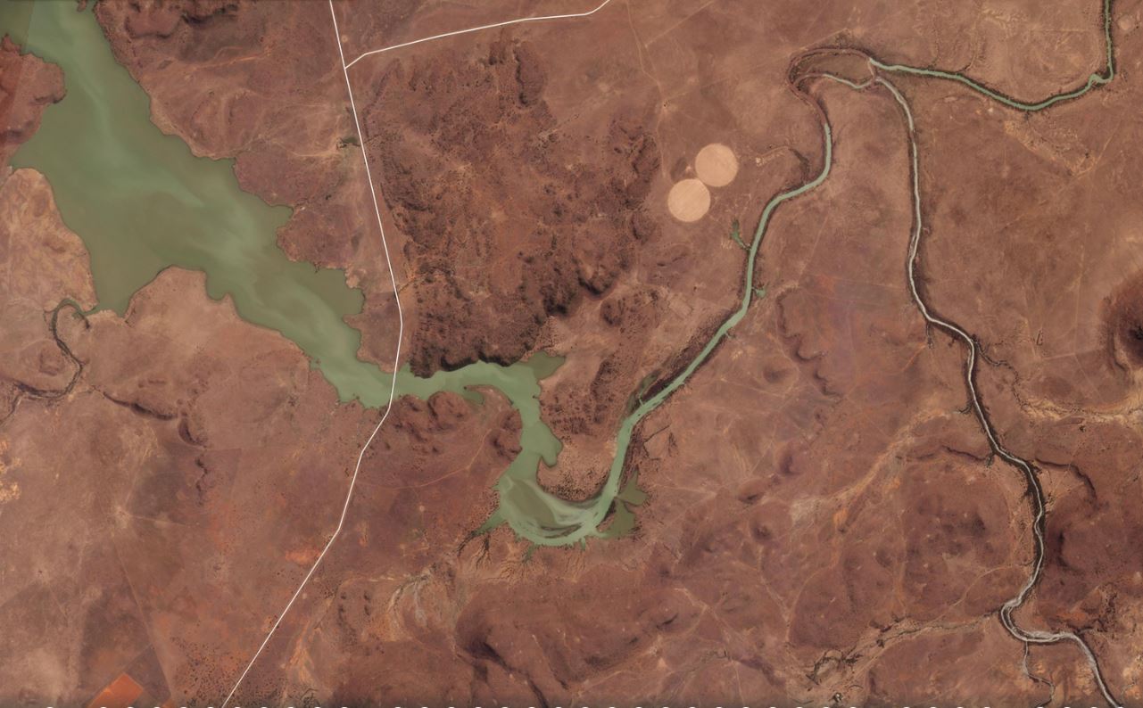
Satellite image of the Kalkfontein Reservoir, collected on 12 September 2022, before the Jagersfontein tailings dam accident. Image copyright Planet Labs, used with permission.
.
Inevitably, there is a great deal of interest in what happened at the Jagersfontein tailings dam site of the in the period leading up to the failure. One key question is whether the facility fell between regulatory stools because it was a reprocessing centre rather than an active mine. It appears from the satellite imagery and from Google Earth that old spoil heaps were being “mined”, with the waste being stored in a greatly expanded tailings storage facility. Operations were suspended at least once, reportedly because of concerns about regulatory compliance.
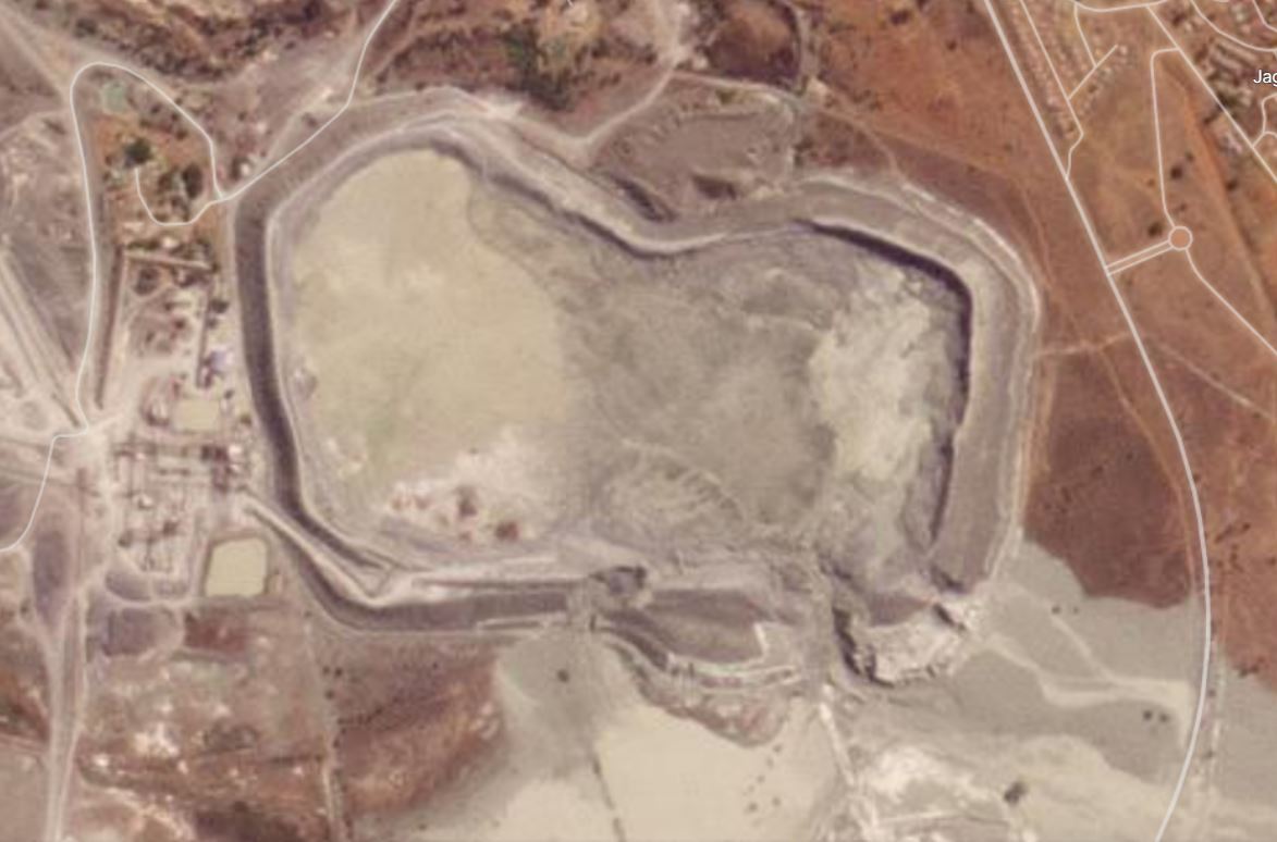
Of particular focus will be the walls on the southern edge of the facility. This is a Google Earth image from February 2019:-
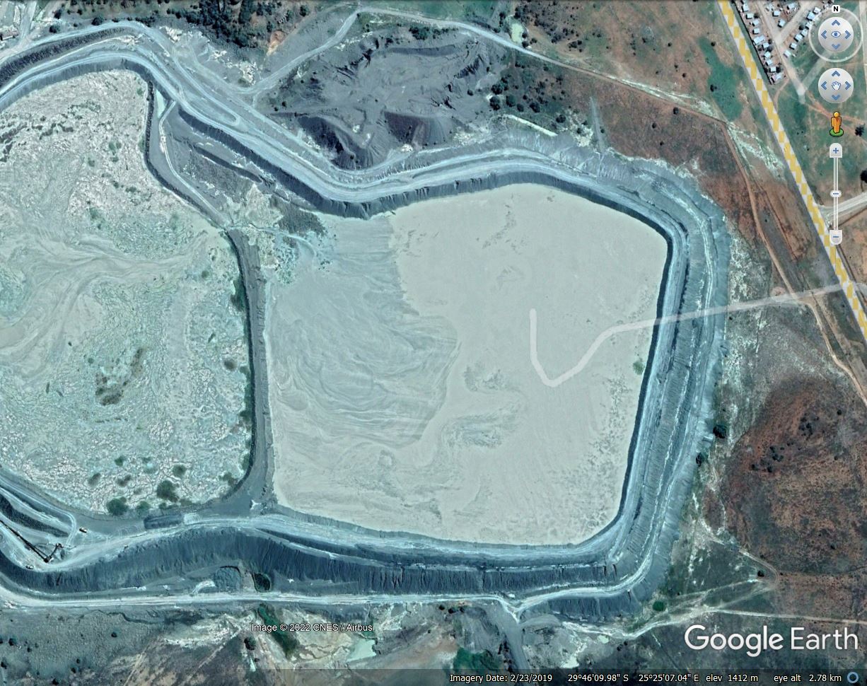
Google Earth image of the Jagersfontein tailings dam from February 2019. Note the walls of dam on the southeastern side.
.
This is the same view from February 2021:-
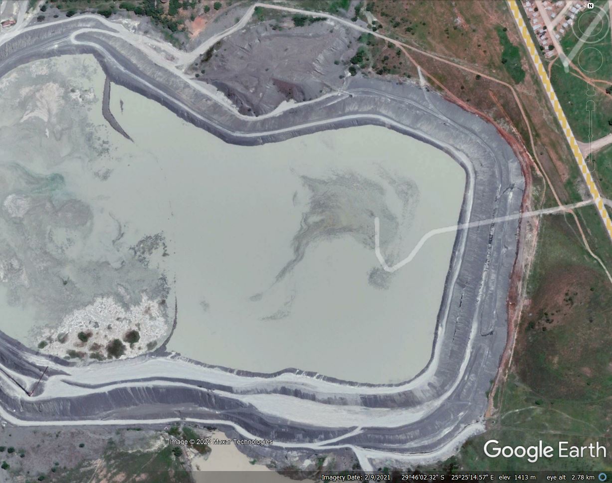
Google Earth image of the Jagersfontein tailings dam from February 2021. Note the buttressed walls of dam on the southereastern side.
.
It is very clear that the wall of the tailings dam on the southeast corner was greatly thickened over the two year period. This was not matched on the east side, for example. This appears on first inspection to have been what might be described as buttressing on the downstream side. No explanation has been provided as yet as to why this occurred, but it is interesting to note that the failure occurred on the southeast wall of the facility.
Reports indicate that there are 400 more tailings facilities in South Africa. In 2020, 52 of these were classified as being “active high risk tailings dams “. I hope that attention will now be paid to ensuring that these are safe.
The weather forecast for Jagersfontien indicates that rain is anticipated on 19 September. Urgent attention is needed to ensure that further mobility of the tailings both in the facility and in the surrounding area is prevented.
.
Reference and acknowledgement
Planet Team (2022). Planet Application Program Interface: In Space for Life on Earth. San Francisco, CA. https://www.planet.com/
13 September 2022
Analysing the aerial and satellite imagery of the Jagersfontein tailings dam disaster
Analysing the aerial and satellite imagery of the Jagersfontein tailings dam disaster
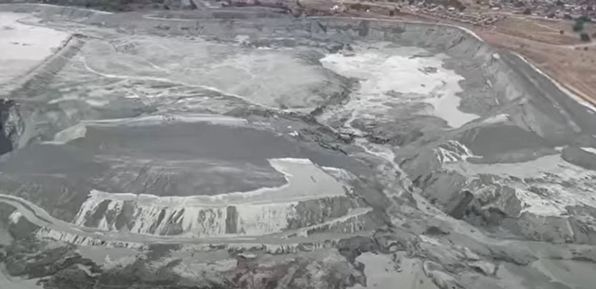
The impacts of the catastrophic tailings dam failure at Jagersfontein are slowly becoming apparent. The plume of slimes has devastated a large area and ruined many lives. Yesterday, aerial footage emerged of the site of the disaster, illustrating the scale of the clean up operation that will be needed:-
.
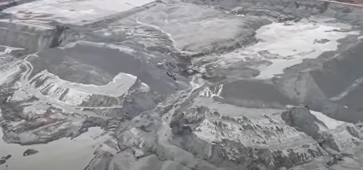
From about 52 seconds this video shows the tailings facility itself, including the breach:-
An aerial image of the site of the Jagersfontein tailings dam failure. Still from a video posted to Youtube by News24.
.
The image shows that the slimes in the eastern half of the facility have mobilised and escaped, but those on the western side appear to have been mostly retained by an internal structure. Ensuring that these do not mobilise must be a very high priority.
The breach itself is heavily eroded, meaning that it is difficult to determine whether the failure was caused by overtopping, piping or slope instability. On both side of the breach, fresh slimes are coating the walls of the tailings dam, illustrating the high mobility of the mine waste. Note the width of the walls of the tailings dam here – much greater than in other parts of the facility. I wonder why?
Whilst the main breach is clear, there are several other locations where there appears to have been substantial erosion of the dam walls. The image below shows these:-
An aerial image of the site of the Jagersfontein tailings dam failure, showing other areas of erosion. Still from a video posted to Youtube by News24.
.
One of these is to the west of the main breach, on the left side of the image above. This appears to threaten the stability of the remaining tailings and needs very urgent attention. There are two more to the east side (on the right side of the image). I am unsure as to how these will have formed. Did the tailings develop waves within the pond that overtopped at other locations? The investigation will need to understand these features.
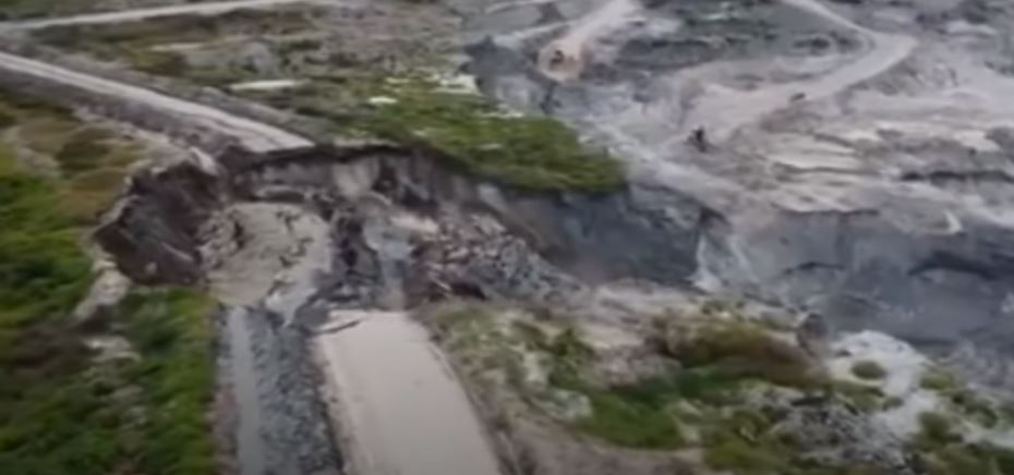
Meanwhile, on the other side of the Jagersfontein tailings facility, another slope failure has occurred:-
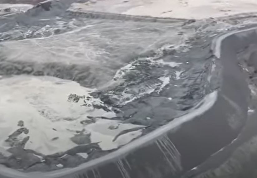
An aerial image of the site of the Jagersfontein tailing dam failure, showing a possible drawdown failure on the opposite side of the facility. Still from a video posted to Youtube by News24.
.
This appears to me to be a slump in the dam walls, possibly associated with the drawdown of the tailings. This will have left transient high pore water pressures in the dam wall, allowing failure to develop.
This is all captured rather nicely in Planet Labs latest imagery from the site, collected on 12 September:-
Satellite image showing the aftermath of the 11 September 2022 Jagersfontein tailings dam failure in South Africa. This image shows the tailings facility itself, including the multiple locations in which the walls have been compromised. Image copyright Planet Labs, used with permission.
.
The main breach is clear in the lower centre right of the image, but the other locations of substantial erosion, and the drawdown failure, can also be seen. As noted above, this image highlights the very urgent need to ensure that no further release of tailings occurs.
Yesterday I noted that the slimes had managed to reach the main channel, but it was unclear as to how mobile they had become. The Planet Labs satellite image below answers the question:-
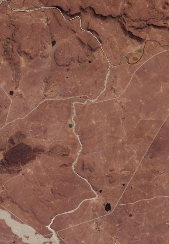
Satellite image showing the aftermath of the 11 September 2022 Jagersfontein tailings dam failure in South Africa. This image shows the slimes in the channel heading north from the mine site. Image copyright Planet Labs, used with permission.
.
It is clear that the tailings have travelled down the main channel, extending many kilometres from the main site. Another priorty now must be to ensure that the slimes being retaining by the small dam at the bottom of this image do not mobilise again.
Finally, it now appears that the ownership of this facility changed earlier this year, and that at the time of failure it was owned by Jagersfontein Developments, part of the Dubai-based Stargems Group. Reuters reports that the approach has been to reprocess the tailings to recover diamonds that have been accidentally dumped. It also reports that operations were stopped in 2020 due to high water levels, but that they resumed in 2021.
.
Reference and acknowledgement
Planet Team (2022). Planet Application Program Interface: In Space for Life on Earth. San Francisco, CA. https://www.planet.com/
12 September 2022
The 11 September 2022 Jagersfontein tailings dam failure
The 11 September 2022 Jagersfontein tailings dam failure
On 11 Seeptember 2022 a catastophic tailings dam failure occurred at the Jagersfontein diamond mine in South Africa. The location of the tailings facility is 29.772, 25.430. This is a Google Earth image of the site:-
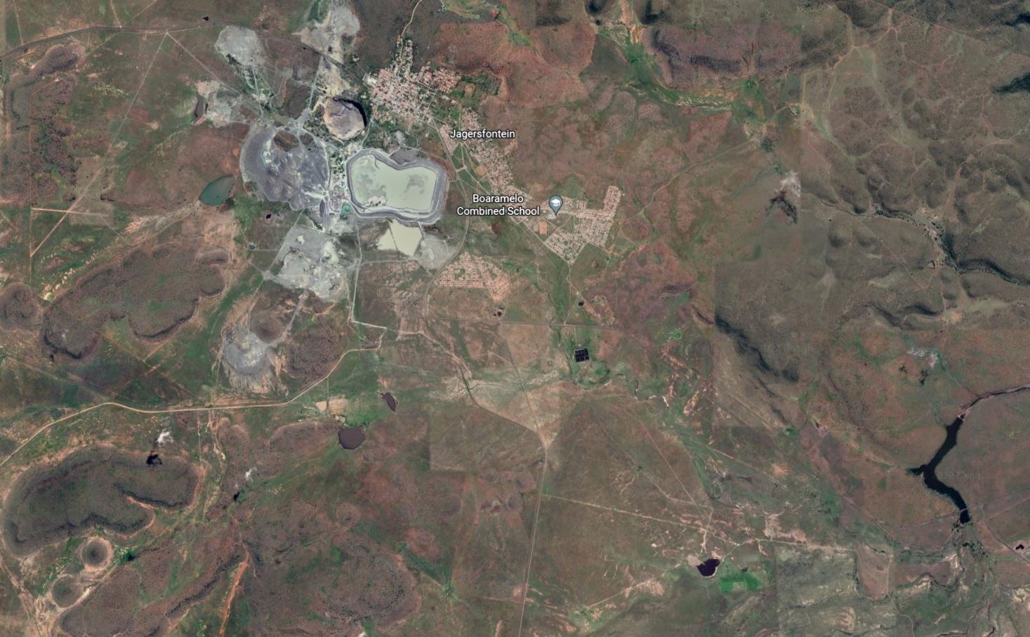
Google Earth image of the Jagersfontein site, including the tailings facility that failed in September 2022.
.
The Jagersfontein diamond mine is closed. Bloomberg has reported that the facility is still owned by De Beers, although there is a remarkable lack of clarity:-
The mine’s dumps and slime still “belong” to De Beers and the government’s access has been restricted by a court order, [Nathi] Shabangu [a spokesman the Department of Mineral Resources and Energy] said. “We also have reports that the mine has been sold to other parties, without the involvement of the DMRE as per the court order,” he said.
There are some videos online showing the collapse of the tailings facility, of which is is perhaps the most remarkable:-
Residents of the mining town of Jagersfontein in the Free State are being evacuated after the mine dam burst at around 06:00 on Sunday, 11 September 2022 causing flooding in parts of the town. pic.twitter.com/5p6iTuWin6
— MDN NEWS (@MDNnewss) September 11, 2022
.
Reports indicate that at least three people have been killed and about 40 people have been hospitalised by the failure.
Planet Labs captured an image of the aftermath of the failure using their lower resolution PlanetScope instrument. Unfortunately, and unusually for this area, the image is slightly cloudy but the scale of the failure is clear enough:-
Satellite image showing the aftermath of the 11 September 2022 Jagersfontein tailings dam failure in South Africa. Image copyright Planet Labs, used with permission.
.
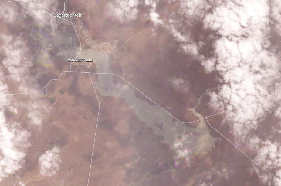
The plume of tailings extends about 8.5 km towards the southeast. It is up to about 1.5 km wide.
The image below shows the aftermath of the disaster in the area of the tailings facility itself:-
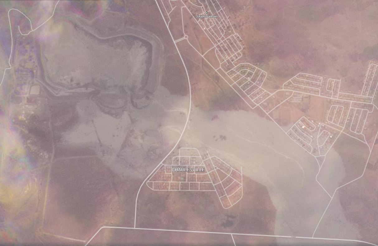
Satellite image showing the aftermath of the 11 September 2022 Jagersfontein tailings dam failure in South Africa. This image shows the failed tailings facility and inundation of local communities. Image copyright Planet Labs, used with permission.
.
The image shows a large breach in the southern wall of the facility. It appears that the pond, which is about 1 km long and 500 m wide, has largely emptied. Many houses downstream of the facility have been inundated.
Worryingly, the satellite images also indicate that the tailings have entered the main channel. Frustratingly, this area was covered in cloud at the time of the image collection:-
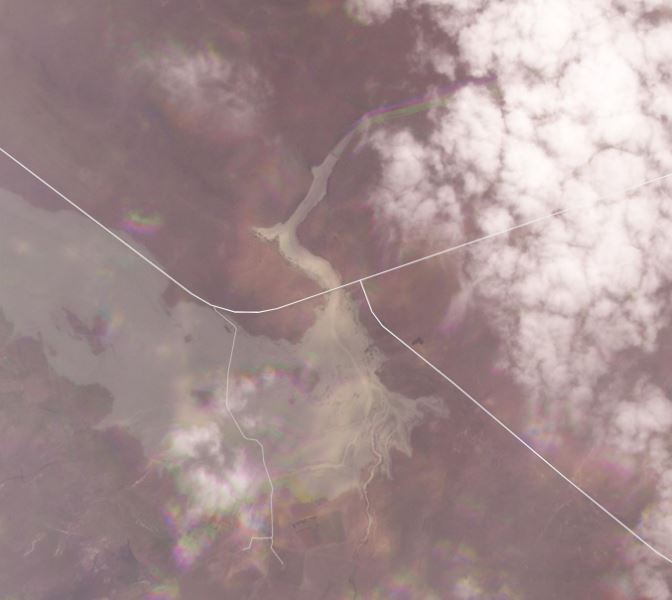
Satellite image showing the aftermath of the 11 September 2022 Jagersfontein tailings dam failure in South Africa. This image shows the tailings entering the main channel. Image copyright Planet Labs, used with permission.
.
The main channel flows out towards the north, with a small dam creating a lake. The image above shows the the dam has been overcome, although it is possible that it has retained a substantial volume of the waste. We will need to wait for better imagery to understand the impact better.
Once again, a major tailings failure has caused loss of life and severe environmental damage. This event, in a facility in which mining has ceased, will further raise questions about the long term stewardship of these facilities.
.
Acknowledgement
Planet Team (2022). Planet Application Program Interface: In Space for Life on Earth. San Francisco, CA. https://www.planet.com/
9 September 2022
Using social media to collect data on landslides in near real-time
Using social media to collect data on landslides in near real-time
Before I start my post today, as a British Citizen I want to express my sadness at the passing of Queen Elizabeth II. She has reigned for all of my life and much more. She was the best of us.
As loyal readers will know, for many years I collected data on landslides that cause fatalities. I started that work in 2003, and it has been widely published and cited. That work was made possible by the emergence of online news sources, and the ability to scan them, plus social media. Others have also collected this sort of data on a global scale, most notably the team at NASA, and of course there has been a range of efforts to compile similar data at national and regional level.
These types of studies have changed our understanding of landslides in time and space. But collecting the data is immensely time consuming (meaning that I have ceased to do so, given my other commitments). So, in recent years there have been attempts to automate the process. In a paper (Pennington et al. 2022) just published in the International Journal of Risk Reduction, Catherine Pennington from the BGS and an international team have taken this work a significant step forward using Artificial Intelligence (AI). This research has also been reported in an excellent article in EOS.
The work is clever. An algorithm continually scans social media for posts on landslides using a very wide range of terms in multiple languages (usefully the article provides the full list of these words). It then harvests images from posts that provide a positive indication. AI is then used to analyse the image to determine whether the post involves a true landslide.
The algorithm has been trained with a large set of landslide images that were evaluated and classified as landslide or other by human observers. Whilst far from perfect, the algorithm is performing well.
The team now have a demonstrator running at, using Twitter data: https://landslide-aidr.qcri.org/service.php#home
Take a look, it’s petty cool. This is the map of landslides that it has detected in the last seven days:-
Landslides detected from Twitter over a seven day period using the algorithm of Pennington et al. (2022). Image from the Global Landslide Detector.
.
Inevitably there are some challenges, notably including how to differentiate between, for example, tweets that show recent landslides and those that show the outcomes of landslide mapping, and thus that are older. But science is iterative, and this is an important and interesting step.
.
Reference
Pennington, C.V.L., Bossu, R., Ofli, F., Imran, M., Qazi, U., Roch, J. and Banks, V.J. 2022. A near-real-time global landslide incident reporting tool demonstrator using social media and artificial intelligence. International Journal of Disaster Risk Reduction, 77, 103089. https://doi.org/10.1016/j.ijdrr.2022.103089.
8 September 2022
The 5 September 2022 landslide at a mine at Labohan Dagang in Malaysia
The 5 September 2022 landslide at a mine at Labohan Dagang in Malaysia
On 5 September 2022 a significant landslide occurred at an active tin (?) mine in Labohan Dagang, Banting, Malaysia. The event was captured on several videos that have been circulating on social media in Malaysia. The two major components of these videos can be seen on Youtube:-
.
The first sequence shows drone footage of the initiation of a component of the landslide. The failure is clearly retrogressive, with the collapse being rotational, but quickly fluidising to generate a highly mobile flowslide:-
Failure of the 5 September 2022 landslide at Labohan Dagang. Still from a video posted to Youtube.
.
The second component seems to show a displacement wave generated by the landslide crossing the base of the pit. The mobility of this flow is exceptionally high. The final part of the video reportedly shows the rescue of an excavator operator who was caught up the landslides. However, most reports indicate that there were no casualties, so I’m glad to say that it is likely that the individual was not injured.
There is comparatively little online about this incident. The Selangor Journal has a brief article, which indicates that the landslide occurred at about 1 pm local time on 5 September 2022. On first inspection from Planet imagery of the area, I suspect that the location is an zone of mine workings at 2.808, 101.578, but this needs to be confirmed. The circumstances of the failure are not at all clear, but some reports indicate that three failures were involved.
A prohibition order has been imposed on the site in the aftermath of the landslide.
There is some confusion about this event online. Some reports suggest that it occurred on 4 September 2022, whilst others claim the accident occurred in an iron ore mine.
.
Acknowledgement
I wish to thank a kind loyal reader and old friend in Malaysia who made me aware of this fascinating event.
7 September 2022
Landslides from the 5 September 2022 earthquake in Luding County, Sichuan
Landslides from the 5 September 2022 earthquake in Luding County, Sichuan
On 5 September 2022, at 12:53 pm local time, a M=6.8 (to be confirmed) earthquake struck Sichuan Province in China, with the epicentre located in Luding County at 29.726, 102.279. At the time of writing the confirmed number of fatalities is 74 according to Xinhua News, with a further 26 people missing. These numbers are likely to change in the coming days. Images suggest that there is substantial damage in Luding County.
It is worth noting of course that this disaster comes on top of the ongoing drought and heatwave in China, which also continues to impose severe lock downs on its population in response to Covid-19. This is likely to have increased both the vulnerability and the long term impact of the seismic event.
The mountainous location of this earthquake has meant that landslides were inevitable. Images are appearing on Chinese media to suggest that there has been a host of significant failures, causing extensive damage and some evidence of flooding. For example, JFDaily has a really good set of images of multiple landslides, including this one:-
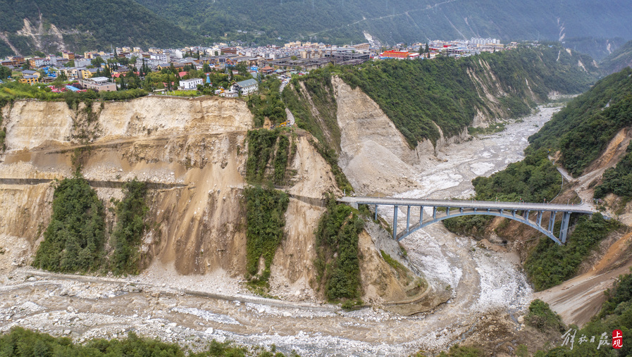
Landslides in terrace deposits triggered by the 5 September 2022 earthquake in Luding County, China. Image via JFDaily.
.
These appear to be shallow landslides in terrace deposits. Note the very extensive damage to the road on both sides of the bridge. The slope has failed both above and below the road.
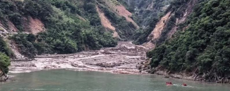
Meanwhile, BJ News has a report in Chinese about landslides on the Wandong River, reporting that three large landslides have occurred. The report indicates that at least one was valley blocking, but that the obstruction has been cleared. The report includes a video showing some of the obstructions, including this dramatic image:-
A valley-blocking landslide on the Wandong River, triggered by the 5 September 2022 earthquake in Luding County, Sichuan. Image from BJ News.
.
Sohu has an annotated image of road damage – unfortunately I cannot translate the text – that is fascinating:-
Landslides triggered by the 5 September 2022 earthquake in Luding County, China. Image from Sohu.
.
The landslides here are shallow, disrupted rockslides, typical of earthquakes in steep mountains. Note the huge damage to the road. The slopes on the left have been far more seriously affected than those of the right, possibly suggesting that slope aspect was a factor in initiation (as we have found elsewhere).
For those on Twitter, @Geo_JunXie (a PhD student at the University of Hull, my new institution) has posted a thread of videos of landslides triggered by the earthquake. They are worth viewing:-
An earthquake of magnitude 6.8 struck near Luding County, Sichuan Province, China today at a epicentre depth of 16 kilometers. The earthquake has triggered a large number of landslides.#earthquake pic.twitter.com/sSbiq26h8c
— JUN XIE (@Geo_JunXie) September 5, 2022
Finally, also on 5 September 2022, at 10:38 am (i.e. before the earthquake), another substantial landslide occurred in China, this time at Shangtan Village in Hualong County in Qinghai Province. China News has a report that includes this image:-
The 5 September 2022 landslide at Shangtan Village in Hualong County, in Qinghai Province. Image from China News.
.
One person was killed by the landslide. Note that the failure appears to have occurred in an benched slope. As per the landslide I featured yesterday at Hongya Village in Qinghai, this may also be a failure in loess, but once again that will need verification.
6 September 2022
The Hongya Village landslide in Qinghai, China
The Hongya Village landslide in Qinghai, China
On 1 September 2022 a very major landslide occurred at Hongya Village in Qinghai Province in China. I am surprised that this event has not attracted more attention – in scale it is certainty one of the most significant landslides of the year to date. The image below, the best I have found, provides an overview of this major failure:-
The aftermath of the 1 September 2022 landslide at Hongya Village in Qinghai. Image via news.cn, originally published by Xinghua.
.
The location of the landslide is 36.860, 101.933. On first inspection the failure appears to have occurred in a loess slope, common in this area, although there is low certainty on this. A report in stnn.cc estimates the volume of the landslide at 3.2 to 3.8 million cubic metres.
As the image above shows, the landslide caused the collapse of two large buildings. In the centre left, one large block has collapsed completely, whilst in the lower left a building has been rotated. The buildings are a part of the No. 3 Middle School in Huzhu County. Fortunately the school was closed at the time of the landslide, reportedly because of the pandemic. This landslide could have been had exceptionally high loss of life but for that piece of luck.
In total it is reported that seven people were killed in the failure. Four people were rescued.
The image below provides an overhead view of the landslide:-
Vertical view of the 1 September 2022 landslide at Hongya Village in Qinghai. Image via GMW.cn.
.
Both images show that there was another large failure to the side of the main landslide at Hongya Village. Some structural damage is evident from this failure, although I can find no detail. But perhaps more significantly, there appears to be a very large, fresh scarp much higher up the slope, with perhaps a suggestion of some deformation downslope from this. Is there a much larger slope failure present here? I cannot find any evidence of this scarp on the archive Google Earth imagery of this site. If so then there will be some substantial future challenges at this site.
5 September 2022
The Clementi landslide in Singapore
The Clementi landslide in Singapore
In the many years that I have been compiling this blog I have rarely had the opportunity to write about landslides in Singapore. Thus, the Clementi landslide, which occurred on 2 September 2022 at the Clementi NorthArc construction site, is a notable event. Clementi NorthArc is a major housing construction project, with almost 1,200 apartments being provided.
The best image of the aftermath of the landslide that I have found is this one, from Channel News Asia:-
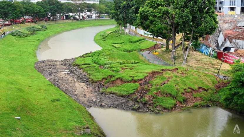
The Clementi landslide in Singapore. Image from Channel News Asia / Try Sutrisno Foo.
.
As the image shows, the landslide blocked the Ulu Pandan Canal. A channel has now been opened up to prevent flooding.
Reports indicate that the collapse involved an under-construction retaining wall, which is captured in some of the images:-
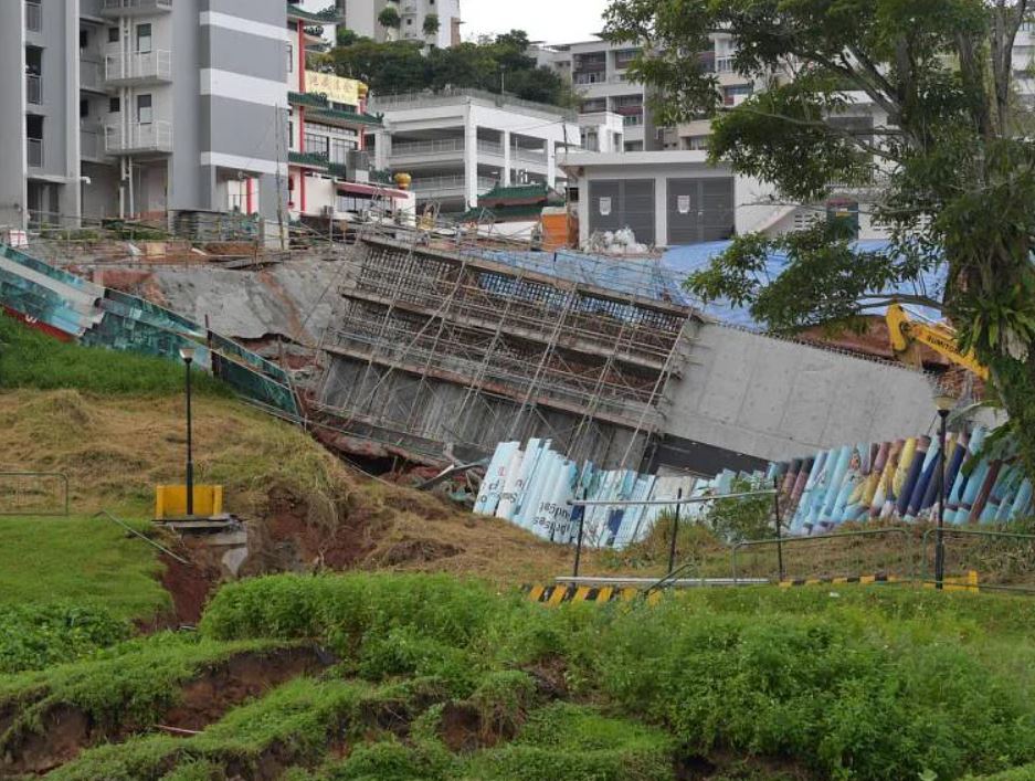
The aftermath of the 2 September 2022 Clementi landslide in Singapore. Image from The Straits Times.
.
Unfortunately I have not been able to track down any aerial or drone footage of the landslide site, so it is a little difficult to interpret the failure. The toe of the slope has displaced a large distance horizontally, whilst the retaining wall has clearly subsided and may have undergone some rotation. Fortunately, it appears that the failure has not jeopardised the stability of the main apartment blocks in the development.
The Clementi landslide is reported to have occurred at 1 am local time, which means that works were probably not underway at the time of failure. One person is reported to have received comparatively minor injuries.
Construction works at the site have now been suspended whilst an investigation is being conducted into the cause of the landslide. It will be interesting to see whether this was a consequence of unanticipated ground conditions (bearing in mind Singapore is a tropical environment with high levels of weathering and rainfall); inappropriate design; inadequate construction; or some other unanticipated factor. It will also be interesting to see whether any signs of impending failure were observed.
2 September 2022
Heavy rain has triggered multiple landslides in New Zealand over the last two months
Heavy rain has triggered multiple landslides in New Zealand over the last two months
Parts of New Zealand have suffered unusually intense rainfall through July and August, triggering multiple landslides. For example, in Wellington, which is a city built on steep slopes, Geonet has reported that 294 mm of rainfall fell in July alone, the highest on record, with further heavy rainfall falling in August. As of 18 August GNS had recorded 195 landslides in July and a further 148 in August. For example, this landslide occurred on The Terrace on 8 August, threatening the house higher up the slope:-
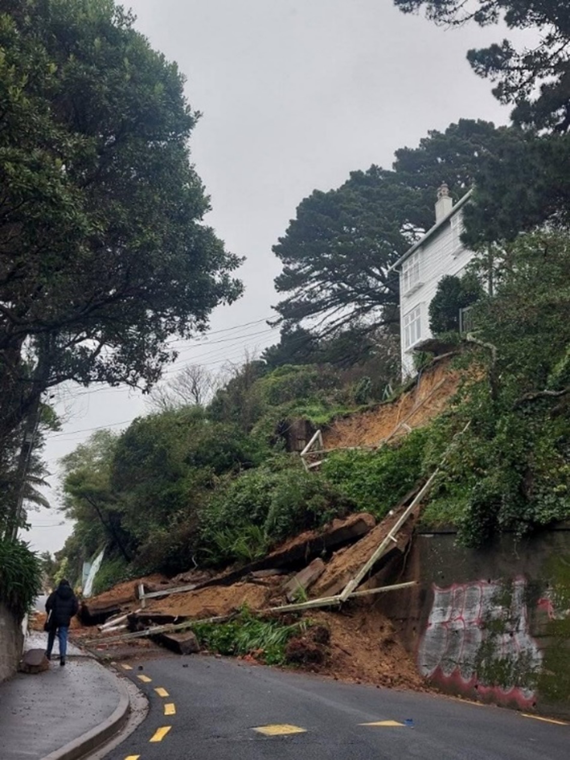
The 8 August 2022 landslide on The Terrace in Wellington. Image courtesy of GNS Science/ Wellington City Council.
.
Other areas have also been affected, most notably Nelson in the northern part of South Island. Perhaps most interestingly, a significant landslide occurred in the Atawhai area of Nelson, which was captured on a video https://www.youtube.com/watch?v=p70sOgxfa_g:-
.
Stuff has an article that explains the context for this landslide:-
Gary Fieldes’ holiday in “sunny Nelson” took an unexpected turn when the bank opposite the home he was staying in began to slip. Fieldes and his wife, from Cambridge, are staying on Sunnybank Rise in Nelson’s Atawhai, house sitting for friends travelling in the United States. When the land opposite the home began to move on Thursday afternoon just after 2pm, Fieldes grabbed his phone. The slip, which started slowly, gained momentum, taking trees with it as it slid over a retaining wall and onto the street.
The most substantial rain occurred a few days later though. Geonet has an article about the landslides triggered between 17 and 22 August. Some areas received over a metre of rainfall. This image shows multiple shallow landslides triggered in the Atawhai area:-
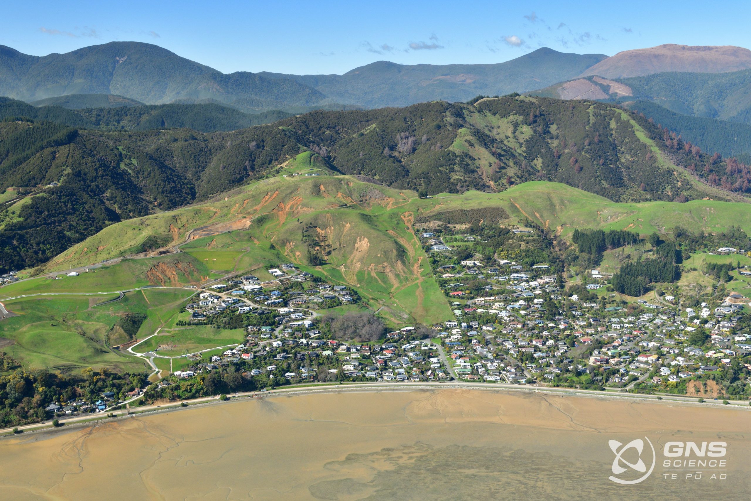
Multiple shallow landslides in the Atawhai area of New Zealand, triggered by heavy rainfall. Image by GNS Science.
 Dave Petley is the Vice-Chancellor of the University of Hull in the United Kingdom. His blog provides commentary and analysis of landslide events occurring worldwide, including the landslides themselves, latest research, and conferences and meetings.
Recent Comments