
28 October 2022
The Duffey Lake landslide: old logging roads and slope failures
The Duffey Lake landslide: old logging roads and slope failures
On 15 November 2021 a series of landslides occurred during a period of heavy rainfall in British Columbia, Canada. I wrote about those landslides at the time. Substantial damage was caused to both Highway 1 and Highway 99. In the most deadly failure, now known as the Duffey Lake landslide, five people were killed and substantial damage was caused to Highway 99.
The Canadian media organisation CBC has a piece that explores the causes of these landslides, highlighting the role of old resource (logging) roads on the hillside above Highway 99. There is a very interesting video, which last about 10 minutes, in the article. It includes this diagram about the two landslides triggered in the Duffey lake area:-
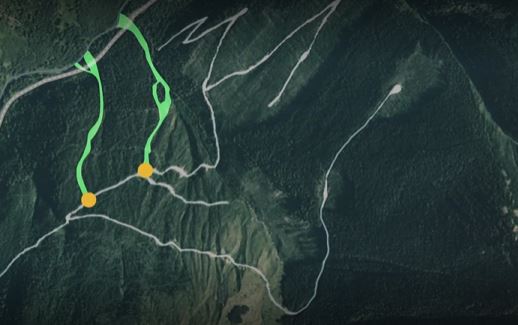
The 2021 landslides at Duffey Lake in BC, Canada. Still from a video produced by CBC.
.
The landslides at Duffey Lake appear to have originated from the sites of an old logging road high up on the hillsides. This road was constructed in the 1960s, and used through to the mid-1990s but then abandoned. The location is at about 50.473, -122.226. I have indicated the approximate location of the crown of the landslide and the impact point on Highway 99 on the Google Earth image below:-
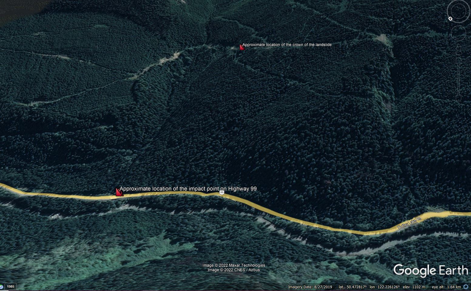
Google Earth image showing the approximate location of the Duffey Lake landslide.
.
The site was investigated by geologist Pierre Friele. His findings are described in an article on the Maple Ridge-Pitt Meadows News website:-
The problem, he said, was in the area of a switchback. Two older, small landslides had left debris resting on the road below the switchback, plugging a ditch. The water then ran down the road instead of crossing over the road and going down a stable slope.
It was the diversion and concentration of water from the road that triggered the initial failures high above Highway 99. Given the steepness of the terrain, they were able to turn into a major landslides that impacted the main road at the foot of the slope.
Interestingly, even the 2019 Google Earth imagery appears to show a couple of small failures on the resource road in the area of the landslide source:-
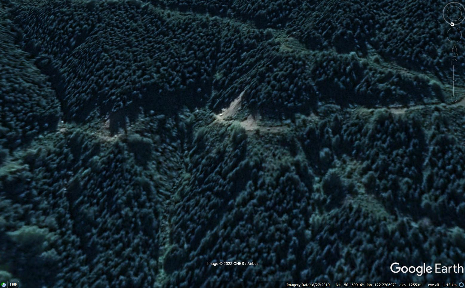
Google Earth image showing small landslides on the resource road close to the source of the Duffey Lake landslide.
.
I have written extensively about poor quality road construction, and its impact on slope instability. In the case of these resource (logging or mining) roads in Canada, it is poor maintenance, or a failure to properly deactivate the roads when they are no longer needed, that is causing the problems.
The CBC article highlights that these roads pose a substantial long term hazard in Canada. It is estimated that there are over 1.5 million kilometres of resource roads – British Columbia alone has 600,000 km of these roads.
27 October 2022
Yucaipa: a remarkable debris flow video from the San Bernardino Mountains
Yucaipa: a remarkable debris flow video from the San Bernardino Mountains
This amazing video captured by San Bernardino county public works – watch all the processes of a #debrisflow of the El Dorado scar September 12, 2022 – heavy rain rates on scar at 8000 feet in 1 hour pic.twitter.com/ZApuQZ5FuP
— Alex Tardy Skiwxman (@SanDiegoWCMwx) October 25, 2022
.
The video is also on Youtube. This series of debris flows, which occurred over the period of a single hour, were generated from the scar of the 2020 El Dorado fire by intense precipitation. The events occurred on 12 September 2022 when the remnants of Tropical Storm Kay triggered heavy rainfall – up to 60 mm was recorded. The debris flows affected two communities, Forest Falls and Yucaiba. The Los Angeles Times has reported that a women was killed in Forest Falls. The same article has some dramatic images of the aftermath:-
The aftermath of the 12 September 2022 debris flows in Yucaipa and Forest Falls, California. Image by Gina Ferazzi / Los Angeles Times.
.
The video shows the complex behaviour of debris flows, with multiple pulses or surges of debris travelling down the channel, which is typical for such events. In the early part of the video, the surges have quite a high density, but note that it appears that there was no rainfall at the site of the camera at the time:-
One of the debris flow pulses in Yucaipa, California. Still from a video posted to Youtube.
.
Later in the video there is heavy rainfall at the camera site. The debris flow had become less dense and was behaving more as a debris flood:-
A later stage of the debris flows at Yucaipa, California. Still from a video posted to Youtube.
.
Note however that some evidence of pulses of debris is still seen.
The Los Angeles Times article highlights the challenges faced by communities affected by such events. This is a quote from Brenda Ebrahim, a resident of Yucaipa whose property has been badly affected by such events:
“We’ve been begging for help for years since they told us this was going to happen,” Ebrahim said. “I’ve been through it, I know how it works. It’s not sustainable. This is California’s new reality.”
Of course we are now moving towards the winter period, when high intensity rainfall events often occur.
.
Acknowledgement
Thanks to Steve Beattie, who spotted this and highlighted it to me via Twitter.
25 October 2022
The Las Tejerías landslide disaster: Planet Labs imagery of the source of the flows
The Las Tejerías landslide disaster: Planet Labs imagery of the source of the flows
The cloud has now cleared sufficiently that Planet Labs has been able to capture an image of the source area of the 8-9 October 2022 Las Tejerías landslide disaster in Venezuela. The image below was captured by one of the PlanetScope instruments on 22 October 2022:-
Satellite image of the source area of the Las Tejerías landslide disaster in Venezuela after the mudslide of 8-9 October 2022. Image copyright Planet Labs, used with permission.
.
The main channel, which flows towards the south to the site of the town, cuts across the image from the west to the south. To the north of the channel there is evidence of many shallow landslides, most of which feed into tributaries of the main channel. In the main drainage line the evidence of high flows can be seen in the form of sediment and/or bedrock exposed or deposited on the channel floor.
For reference, the image below shows the same location on 23 September 2022, before the disaster:-
Satellite image of the source area of the Las Tejerías landslide disaster in Venezuela before the mudslides of 8-9 October 2022. Image copyright Planet Labs, used with permission.
.
In the juxtapose below I have tried to compare the two images:-
.
The juxtapose images highlight clearly the role of the multiple shallow landslides that have become channelised mudflows / debris flows to cause the destruction in the town. These types of landslides are characteristic of extreme rainfall events.
Meanwhile, heavy rainfall continues to cause extensive damage in Venezuela, with another period of rainfall occurring yesterday. This video shows flooding in Montaña Alta:-
https://twitter.com/noticiasjdg/status/1584657238719098882
.
Reference and acknowledgements
The images are from the wonderful people at Planet Labs.
Planet Team (2022). Planet Application Program Interface: In Space for Life on Earth. San Francisco, CA. https://www.planet.com/
24 October 2022
The Barry Arm landslide in Alaska: increased rates of movement
The Barry Arm landslide in Alaska: increased rates of movement
On Friday the Alaska Division of Geological & Geophysical Surveys (DGGS) posted an update on the movement of the Barry Arm landslide. It provides strong guidance for people located on or close to the fjord in the vicinity of the landslide:-
- Due to the ongoing hazard, we ask people to exercise their best judgement and, where possible, limit travel in the Barry Arm area, including Harriman Fjord, Barry Arm, College Fjord, and upper Port Wells.
The Barry Arm landslide is a 500 million cubic metre landslide situated above Prince William Sound in Alaska. The Alaska DDGS has a quite detailed description of the landslide, which has been moving since at least 1957. However, one section is causing particular concern, as per this image:-
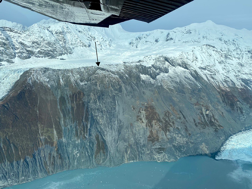
The rapidly deforming section of the Barry Arm landslide in Alaska. Image by Katreen Wikstrom Jones of the DGGS, State of Alaska.
.
This section of the slope is known as the Kite, although adjacent areas to the right on the image are also actively moving. A very large rear scarp has formed at the crown of the Kite, as indicated by the arrow in the image.
On 16 September 2022, the DGGS reported that the landslide was moving at 40 to 70 mm per day. As the image above shows, the section that is active is located directly above the fjord. A major failure would likely trigger a displacement wave, although the size will depend on the volume of failure and the dynamics of the movement.
The landslide is located at 61.139, -148.169, and is clearly visible on Google Earth. There is much that is unknown, most notably the thickness of the moving mass. Unfortunately, access is currently restricted due to the risk associated with being on the water in the vicinity of the landslide.
Forecasting the likely future behaviour of large, unstable rock masses is very difficult. Loyal readers will remember the trials and tribulations faced by the monitoring team, and the local residents, of the Velsemannen rockslide in Norway, which repeatedly went through phases of accelerated movement that did not lead to failure. Indeed, in this case a large-scale collapse is not inevitable, but the risk is high.
The DGGS will post a further update on Friday “unless significant changes warrant earlier updates”.
21 October 2022
Novyi Svet: A large landslide in a landfill site in Russia
Novyi Svet: A large landslide in a landfill site in Russia
On Thursday 20 October 2022 a large and notable landslide occurred at a landfill site in the village of Novyi Svet (Новый свет) in Gatchinsky, Russia (the village is at 59.559, 30.201). Unsurprisingly in these troubled times this has not been reported in the western media, but it is an impressive failure.
The Russian website 78.ru has this image of the aftermath of the landslide:-
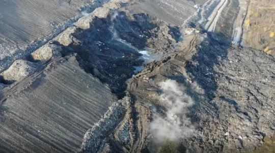
The landslide at a landfill site Novyi Svet (Новый свет) in Russia. Image from 78.ru.
.
There are some videos on Twitter, of which this is a good example (please excuse the music):-
レニングラード州ガッチナでごみ山が崩落して悪臭がすごいとの事。
ここを管理している会社はНовый Свет-ЭКО pic.twitter.com/4bvZSgJAbP— しか (@shika_ishi) October 20, 2022
.
This is a still taken from that video:-
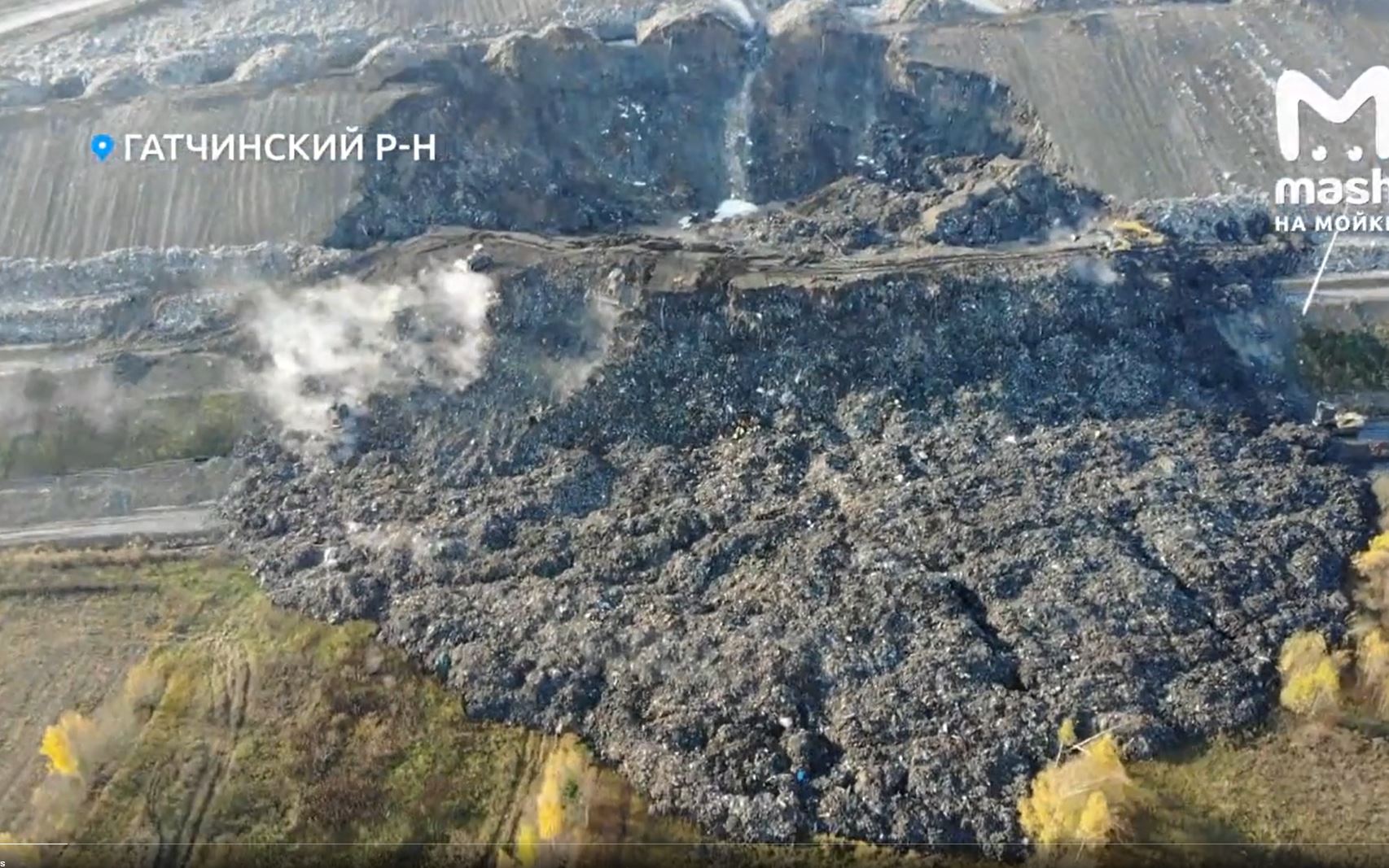
The landslide at a landfill site Novyi Svet (Новый свет) in Russia. Image from a still from a video that was tweeted by @shika_ishi.
.
This appears to be a rotational landside in the wall of the landfill site. The lower part of the landslide has transitioned into an earthflow. Many of the images show smoke, suggesting that there is some combustion of the waste occurring.
The Russian website dp.ru has a more detailed description of the landfill (in Russian). The site accepts domestic waste from Gatchinsky district of the Leningrad region and ten districts of St Petersburg. Despite the failure it continues to operate as usual. The height of the walls of the facility is about 60 m, and the site has been in operation since 2001. No-one was killed or injured in the landslide.
I can find no information as to a likely trigger or cause of this unusual landslide at Novyi Svet (Новый свет). I have covered a number of tragic landfill / garbage landslides over the years, including several in poorer countries that have caused multiple fatalities. In general such failures occur because of poor management of the waste and/or of the water and gas that landfill sites generate.
20 October 2022
Landslides from the 14 August 2021 M=7.2 earthquake in Haiti
Landslides from the 14 August 2021 M=7.2 earthquake in Haiti
On 14 August 2021 an Mw=7.1 earthquake struck Nippes Department in Haiti. The earthquake, which was shallow (just 10 km), killed at least 2,248 people, with more than 12,200 injured, and at least 137,500 buildings were damaged or destroyed.
The landslide triggered many landslides. In an open access paper just published in the journal Natural Hazards and Earth System Sciences, Havenith et al. (2022) report the results of mapping and analysis of the landslide distribution. In total they identified 7,091 landslides, a much lower total than were mapped for the devastating January 2010 earthquake in Haiti. However, the mapping technique used here did not allow the smallest landslides to be detected. The surface area of the mapped landslides for the 2021 event is large (80 km²), indeed much larger than for the 2010 event. Thus, Havenith et al. (2022) have concluded that the total number of triggered landslides in the 2021 event was probably larger.
Some of the areas of landsliding are spectacular. This for example is a zone highlighted in the paper, located close to the trace of the fault:-
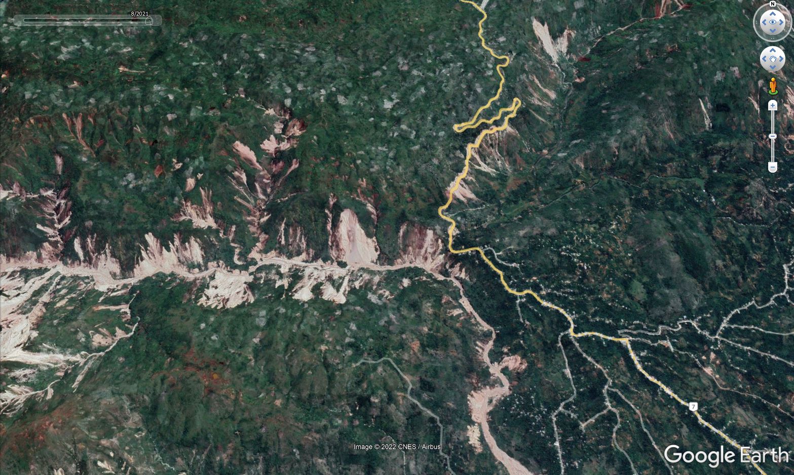
Google Earth image of the aftermath of the 14 August 2021 earthquake in Haiti. This image was collected on 23 August 2021.
.
Havenith et al. (2022) consider why the area of landsliding in the 2021 event was larger than was the case in 2010. The magnitude of the 2021 earthquake was a little higher, which may account for some of the effect, but they believe that other factors might be in play. For example, this area was affected by a M≈7.5 earthquake in 1770, which may have preconditioned the slopes for failure, although the authors recognise that this is hard to quantify. Additionally, the terrain in the western part of Haiti might be more susceptible to landslides (the authors are working on a further paper exploring this issue).
But perhaps most interestingly, Havenith et al. (2022) suggest that the area had been preconditioned for failure by Hurricane Matthew, which struck Haiti in October 2016. This major storm generated very high precipitation totals “precisely over the area that was later hit by the earthquake”. The area was hit by another tropical storm, Grace, a few days after the earthquake, which caused further landsliding, although the impact appears to have been quite limited.
The idea that the slopes has been preconditioned by previous events is very interesting. We explored this idea for earthquake induced landslides in New Zealand in a paper led by my former PhD student Rob Parker (Parker et al. 2015). The evidence is strengthening that major seismic and rainfall events leave a legacy in the hillslopes that subsequent events exploit magnifying impacts.
This of course has key implications for our understanding of the likely impacts of climate change. As the frequency of very intense rainfall increases, we will see not only more landslides being directly triggered but also more damage in the slopes that can be exploited by subsequent storms (or earthquakes).
Research of this type is in its infancy, but it is a very exciting area of investigation.
.
References
Havenith, H.-B., Guerrier, K., Schlögel, R., Braun, A., Ulysse, S., Mreyen, A.-S., Victor, K.-H., Saint-Fleur, N., Cauchie, L., Boisson, D., and Prépetit, C. 2022. Earthquake-induced landslides in Haiti: analysis of seismotectonic and possible climatic influences. Natural Hazards and Earth System Sciences, 22, 3361–3384, https://doi.org/10.5194/nhess-22-3361-2022.
Parker, R.N,., Hancox, G.T., Petley, D.N., Massey, C.I., Densmore, A.L., Rosser, N.J. 2015. Spatial distributions of earthquake-induced landslides and hillslope preconditioning in the northwest South Island, New Zealand. Earth Surface Dynamics, 3 (4), 501-525.
18 October 2022
Las Tejerías: landslides in the upstream catchment
Las Tejerías: landslides in the upstream catchment
Cloud is continuing to render it difficult to get a full understanding of the causes of the 8-9 October 2022 Las Tejerías landslide disaster in Venezuela, obstructing the view from satellites. However, loyal reader Fab has found a tweet with some helicopter video taken in the catchment. The Tweet should be visible below:
Vista aérea de las #Tejerias pic.twitter.com/kMggnT19tH
— Gregoria Díaz (@churuguara) October 12, 2022
.
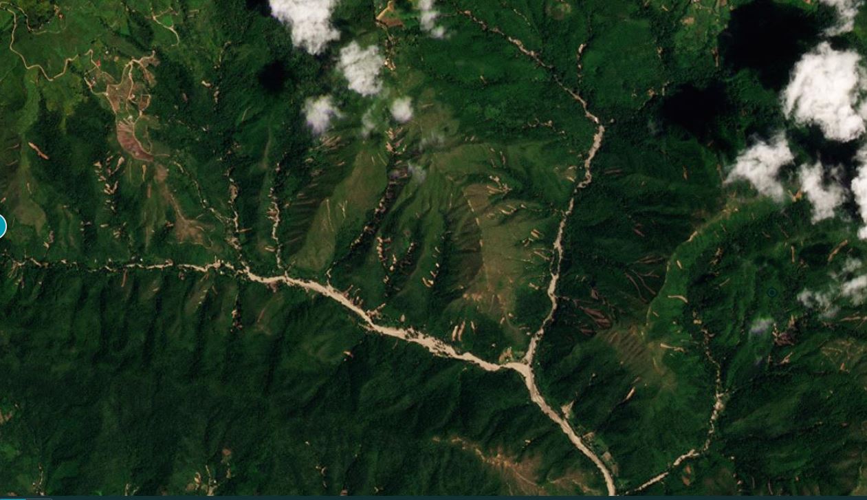
The video was posted by Gregoria Díaz, a journalist in Venezuela. The footage is very revealing. Right at the start it incudes images of two sets of disrupted rockslides in steep catchments:
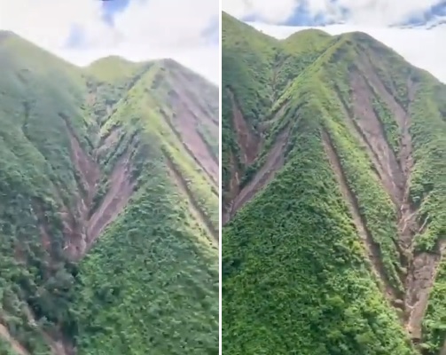
Landslides in the catchment of the Rio Las Tejerías. Still from a video tweeted by Gregoria Díaz (@churuguara).
.
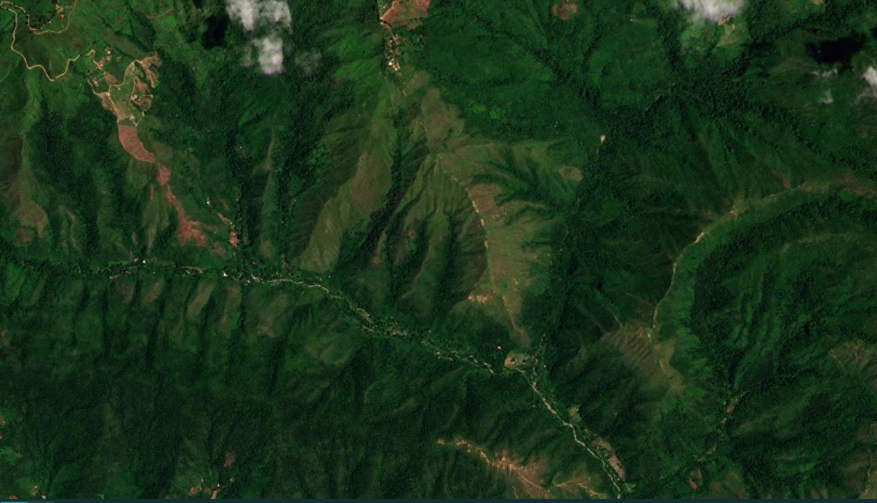
Other parts of the video show shallow failures with long debris trails on steep forested slopes:-
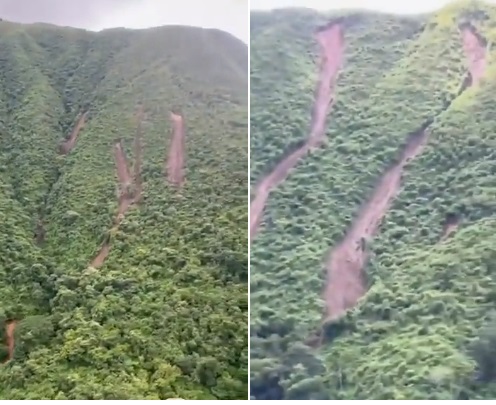
Shallow landslides with long debris trails in the catchment of the Rio Las Tejerías. Still from a video tweeted by Gregoria Díaz (@churuguara).
.
In the second set of images the landslides appear to be comparatively small initial failures, shallow in nature, which have then entrained soil and debris downslope. In most cases there appears to be good connectivity with the main channel.
Thus, an initial diagnosis is that the Las Tejerías landslide disaster was caused by extreme rainfall in the catchment that triggered multiple landslides, which evolved into channelised debris flows that travelled down the main channel to impact the town.
In terms of losses, the confirmed number of fatalities is now 54, with a further eight people remaining missing.
Heavy rainfall continues to cause losses in other parts of Venezuela. In El Costano, a suburb of Maracay, the capital of Aragua state, a mudslide killed three people on 17 October 2022. Once again there is dramatic footage on Twitter showing the landslides in full flow:
Aviso ⚠️ En Venezuela se esta viviendo una emergencia en sector "El castaño" #Maracay pic.twitter.com/dwW3oxL66E
— X (@EarthquakeChil1) October 17, 2022
.
#URGENTE Sector Los Castaños estado Aragua, inundaciones mantienen en angustia a sus habitantes pic.twitter.com/DyXUjegJ0Q
— Esteninf Olivarez (@esteninf) October 17, 2022
.
Interestingly, the President of Venezuela Nicolas Maduro has been clear as to the causes of these landslides, as reported by France 24 / AFP:
Maduro later traveled to El Castano, where he said “all this is climate change.”
“This year the rainfall has been very difficult for the whole country.”
Maduro said that in 2022, he has seen the worst natural disasters in his nine and a half years in office.
12 October 2022
Las Tejerías: Planet Labs imagery starts to clarify the sequence of events
Las Tejerías: Planet Labs imagery starts to clarify the sequence of events
The cost of the Las Tejerías landslides in Venezuela is slowly becoming clear. El Pais indicated today that to date 39 bodies have been recovered from the town, with a further 56 people missing. The prospects of any further survivors are now close to zero, such that the final toll will be almost 100 people. Nicolás Maduro, the President of Venezuela, has now visited the town and pledged to rebuild it, although history from similar sites around the world shows that such promises are frequently not delivered. Meanwhile there are complaints that the media has been limited in its ability to report on the disaster.
At the start of this news report there is some footage of the site (thanks to loyal reader Ryukai for highlighting this in a comment):-
.
The trail of sediment through the town is clear. Planet Labs has captured an image of the site; unfortunately the area to the north remains shrouded in cloud:-
Satellite image of Las Tejerías in Venezuela after the mudslide of 8-9 October 2022. Image copyright Planet Labs, used with permission.
.
This image clearly shows that the main flow came down the channel of the Rio Las Tejerías, which flows through the town from the north, as I speculated on Monday. This has flows into the town, causing extensive damage to the properties close to its banks. The inundation in the main part of the town can be seen. In fact, most of Las Tejerías is constructed on a delta formed by this channel, so the hazard was clear.
In the visible sections of the Rio Las Tejerías the effects of the mudflow can be seen. Unfortunately, the upper reaches of this channel remain covered in cloud, so it is not possible to determine what caused the flow. Hopefully the cloud will clear in the coming days.
.
Reference and acknowledgement
Planet Team (2022). Planet Application Program Interface: In Space for Life on Earth. San Francisco, CA. https://www.planet.com/
10 October 2022
The 8-9 October 2022 disaster at Las Tejerías in Venezuela
The 8-9 October 2022 disaster at Las Tejerías in Venezuela
Over the night of 8-9 October 2022 a rainfall-induced disaster struck the town of Las Tejerías in Venezuela. 2001 Live is reporting about 30 known fatalities, with 54 people missing, some of whom are young children. The disaster is being widely described as a landslide – for example BBC News is reporting that:-
“Deadly landslides have swept away homes in Venezuela’s Las Tejerías city, south of the capital Caracas.”
There are some images of the aftermath of the disaster, including this image from ACN:-
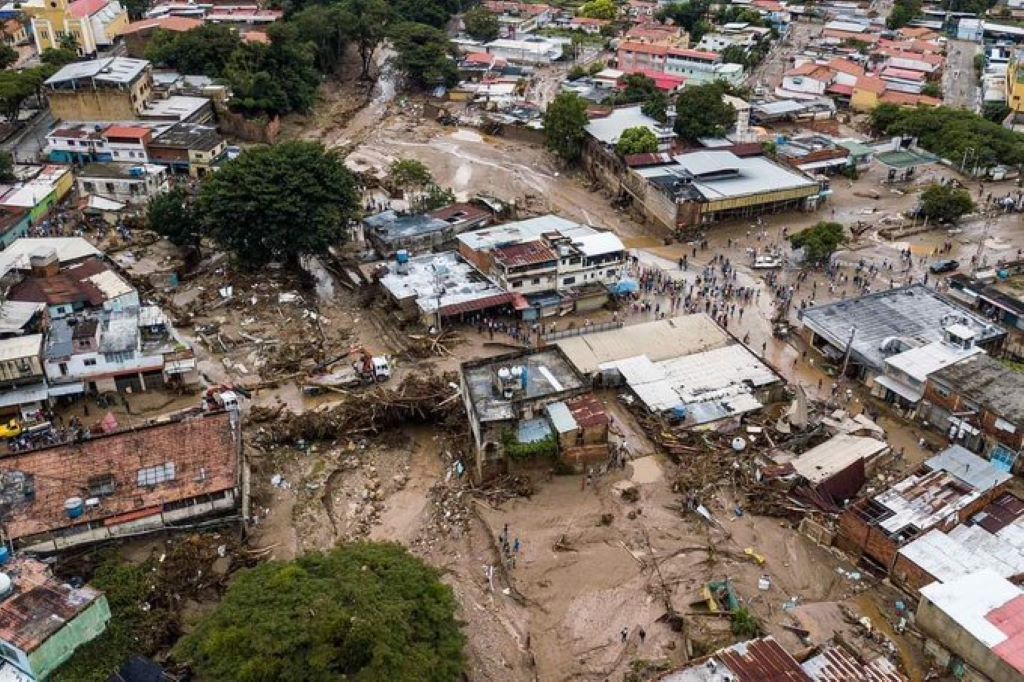
The aftermath of the October 2022 disaster as Las Tejerías in Venezuela. Image from ACN.
.
The images appear to show large amounts of mud and debris in the town, including a considerable volume of wood. The debris seems to be predominantly fine-grained.
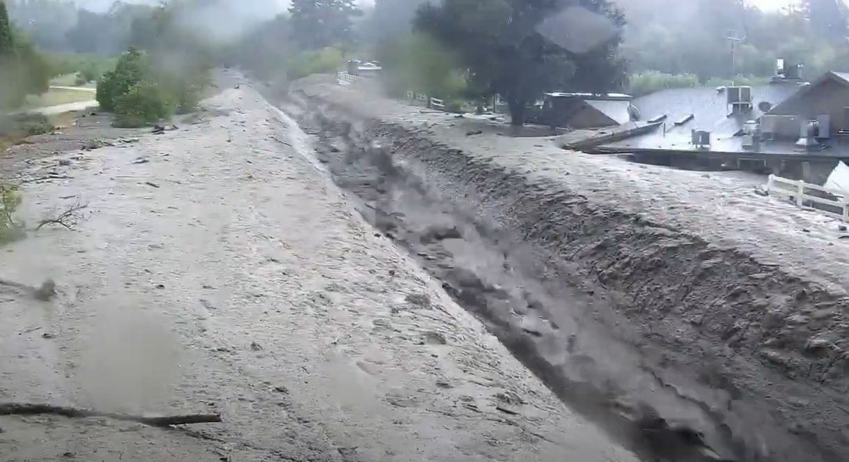
There are also a small number of videos online, captured during the event, which mostly seem to show fast moving, sediment-rich flows. This is an example:-
https://twitter.com/Estapasandove/status/1578943702042521601
.
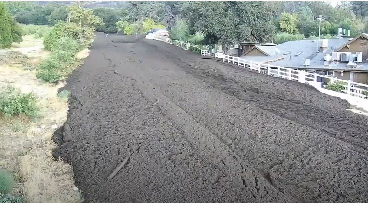
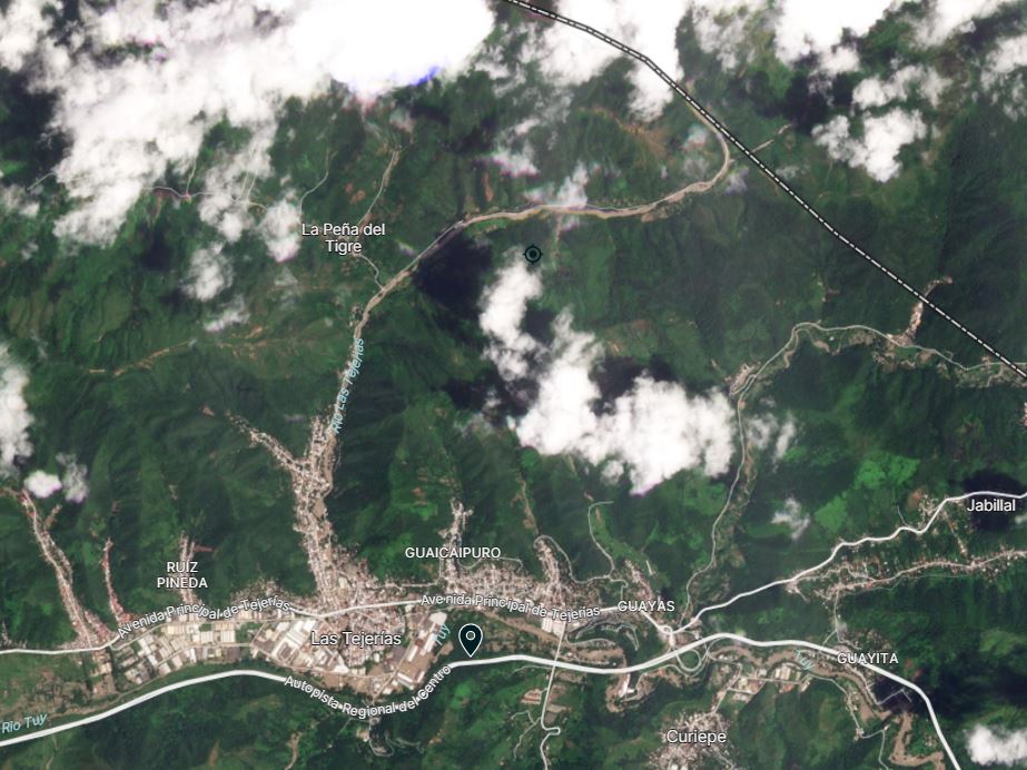
This is a overview of the site from Google Earth:-
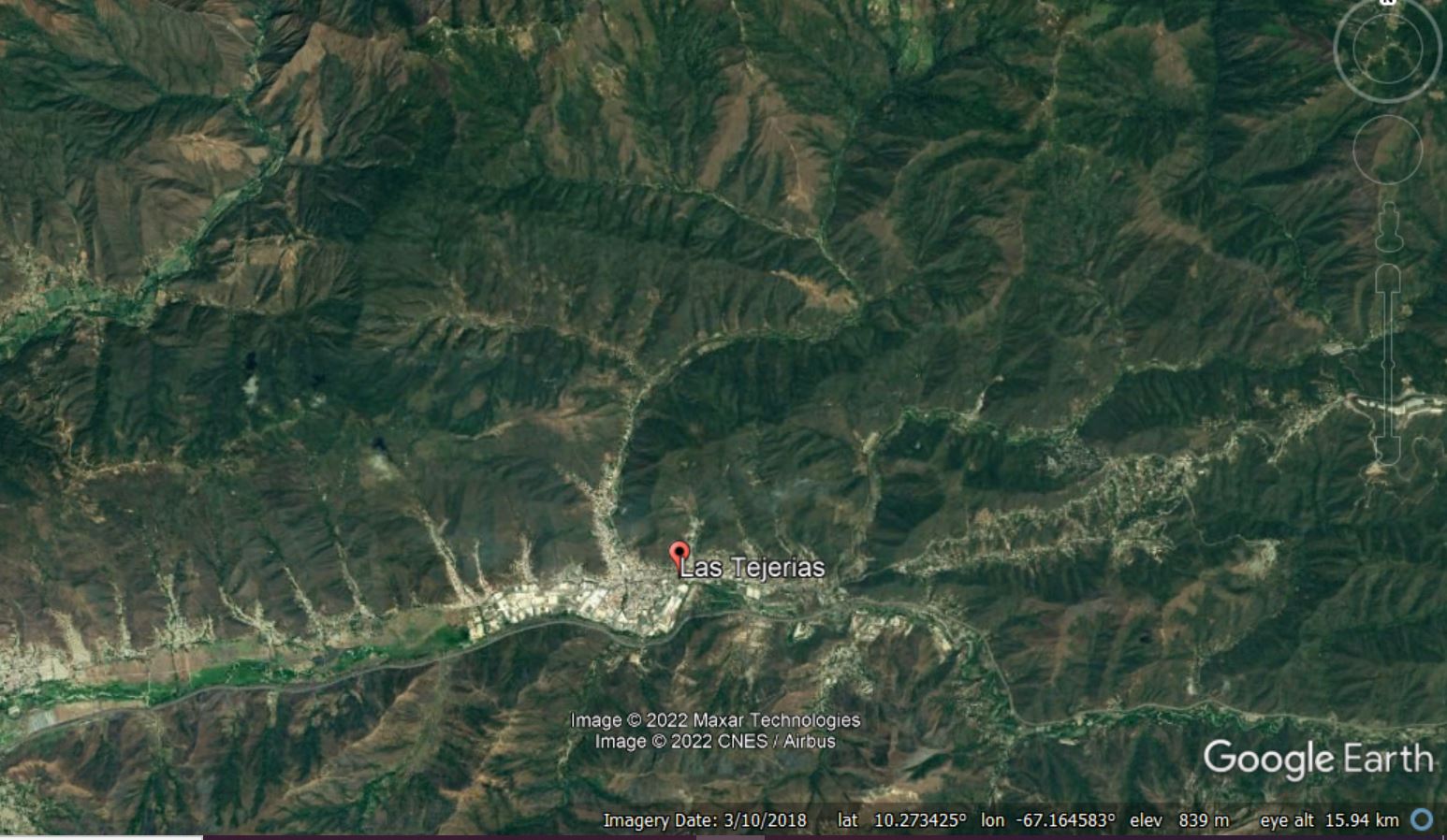
Google Earth view of the town of Las Tejerías in Venezuela.
.
The location is 10.252, -67.166. It is quite unclear at the moment as to the sequence of events at Las Tejerías. Particularly pertinent here might be the large channel that flows southwards through the town to join the main channel, draining the hills to the north. There is dense settlement along this channel. There are also several other, smaller, channels draining minor catchments, also with dense settlement patterns:-
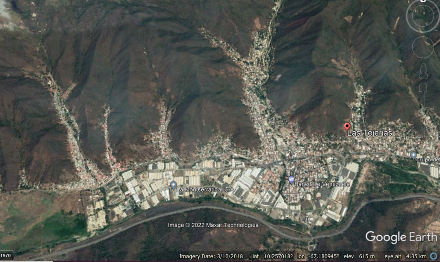
Google Earth view of the densely occupied channels within the town of Las Tejerías in Venezuela.
.
A reasonable first order hypothesis for this disaster may be that it was caused by mudflows travelling down one or more of these channels, triggered by heavy rainfall in the hills to the north. These events could have resulted simply from the heavy rainfall, from multiple landslides in the catchment that have transformed into channelised mudflows, or from a valley-blocking landslide in one or more channels, that breached to create a large flow. At the moment this is purely speculation.
At the time of writing the focus is on the recovery operation, but hopefully in due course satellite imagery will become available that will allow a more detailed analysis of the causes of the disaster at Las Tejerías.
5 October 2022
The Cochin slide: a huge submarine landslide
The Cochin slide: a huge submarine landslide
I usually write here about landslides on land, but the largest and, in many ways, most impressive failures occur in the oceans. In a paper published in the journal Landslides, Bijesh et al. (2022) describe the Cochin slide, a huge failure that lies in the Cochin offshore region on the southwestern continental margin of India. This is a bathymetric image from the paper showing the landslide:-
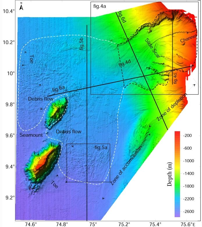
High-resolution multibeam bathymetry map of the Cochin slide, from Bijesh et al. (2022). The black dashed line indicates the boundary of the slide scar, whilst the white dashed line indicates the boundaries of the landslide deposit. The colours indicate the water depth as per the key on the lower right side.
.
The statistics of this landslide, as with many other submarine failures, are astounding. The landslide slide scar is 46 km wide, with an evacuated volume of about 240 km³. The gradient of the landslide scar is just 2º. The landslides scar covers an area of about 2,000 km², whilst the landslide deposits extend over about 5,700 km². The maximum runout distance (from the crown of the landslide scar to the toe of the deposit) is about 138 km (for context, the direct distance between New York and Philadelphia is about 130 km).
Whilst landslides on this scale are scientifically fascinating, and there remains a great deal to learn, a key focus is of course on the hazard potential, and in particular the likelihood of such an event generating a tsunami. A key element of this is to understand the likely trigger of such events. In the case of the Cochin slide this is unclear. Bijesh et al. (2022) speculate that key factors could have been “sedimentation, formation of weak layers, and extensive faulting in the shelf/slope region. It is also inferred that the offshore extension of the major lineaments and deep-seated faulting resulting in weak planes and earthquakes in the region have also influenced the triggering of the Cochin slide.”
Whilst the location and volume of the landslide are compatible with a tsunami-generating event, tsunamigenic submarine landslides also require rapid acceleration of the landslide mass and the presence of stiff, cohesive materials. At present it is unclear as to whether these criteria were met by the Cochin slide. Finally, it is not known as to when the landslide occurred.
Further research is required for sure, and Bijesh et al. (2022) have made some suggestions as to what should happen next, including sampling and analysis of the slide deposits; more detailed imaging; modelling; and investigation of the potential role of sea level change in this region. To these I would add further investigation of the tectonics of the area.
This is a great example of a large submarine landslide with potential consequences for coastal communities in the region, as well as for seafloor infrastructure. I shall look forward to reading about subsequent research on this impressive landslide.
.
Reference
Bijesh, C.M., Twinkle, D., Susanth, S. et al. 2022. Large-scale submarine landslide in the Cochin offshore region, southwestern continental margin of India: a preliminary geophysical understanding. Landslides (2022). https://doi.org/10.1007/s10346-022-01969-6
 Dave Petley is the Vice-Chancellor of the University of Hull in the United Kingdom. His blog provides commentary and analysis of landslide events occurring worldwide, including the landslides themselves, latest research, and conferences and meetings.
Recent Comments