
10 November 2016
Planet Labs satellite image of the Lamplugh Glacier landslide
Posted by Dave Petley
Planet Labs satellite image of the Lamplugh Glacier landslide
The new private satellite image provider, Planet Labs, has the capacity to collect high resolution imagery to order. A few weeks ago I highlighted an image that they had collected of the giant, and somewhat bizarre, avalanches in Tibet. Earlier this week they tweeted that they have collected an image of the massive Lamplugh Glacier / Glacier Bay landslide in Alaska, which I featured back in June, with a follow up a little later. The tweet from Planet Labs stated:
Our satellites spotted this massive landslide on Alaska’s Lamplugh Glacier in August.
As a reminder, this is a very large landslide – about 10 km with a mass of around about 150 million tonnes. It occurred on 23rd June 2016 at 08:20 local time.
The image that Planet Labs have tweeted is fantastic. I have no link with them, so no nothing about the context of the collection of this data, but the image is undoubtedly worth posting:
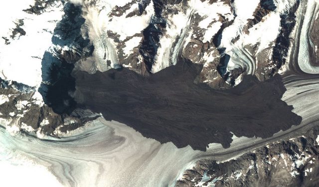
Planet Labs satellite image of the Lamplugh Glacier landslide in Alaska
.
The little wisps of dust at the head of the landslide suggest to me that there was some ongoing rockfall activity in this area when the image was collected (which is not surprising). The image beautifully captures the flow lines in the landslide – note how they deviate outwards on the margins of the landslide deposit to create the tongue structures that seem characteristic of rock avalanches flowing across ice. The interaction between the landslide and the terrain towards the top of the image is also interesting; in particular the way the landslide mass has travelled up the slope slightly to the right of centre could be used to gain an understanding of local velocity.
This is a landslide that deserves further study; I hope that someone is taking on that task.
Other posts that may be of interest:
- Glacier Bay Landslide in Alaska: a satellite image and new videos
- Lamplugh Glacier rock avalanche: A massive new landslide in Alaska on Tuesday
- The Tyndall Glacier landslide: images from the University of Alaska Fairbanks
- The Tyndall Glacier landslide in Alaska: the largest recorded non-volcanic landslide in North America
- Sitka landslide in Alaska – the potential power of simple geomorphic mapping
- Ferebee Glacier: another rock avalanche in Alaska
- Mount La Perouse: Sunday’s rock avalanche in Alaska has been found
 Dave Petley is the Vice-Chancellor of the University of Hull in the United Kingdom. His blog provides commentary and analysis of landslide events occurring worldwide, including the landslides themselves, latest research, and conferences and meetings.
Another view captured by Sentinel-2 on Sep 29 (and it’s open data) https://twitter.com/sgascoin/status/796812674877325312