
15 November 2022
The impact of the Williamson Diamond Mine tailings breach
The impact of the Williamson Diamond Mine tailings breach
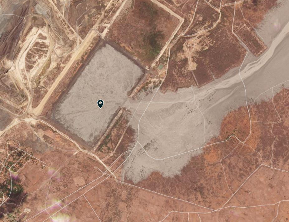
The high resolution Planet Labs SkySat satellite image of the Williamson Diamond Mine tailings dam breach, which I featured last week, also shows the impact of the mine waste on downstream communities. This image shows the inundated and overtopped dam downstream of the tailings storage facility (TSF). At the site of the spillway to the north, now filled with tailings, there is a small community that has been heavily affected by the waste:-
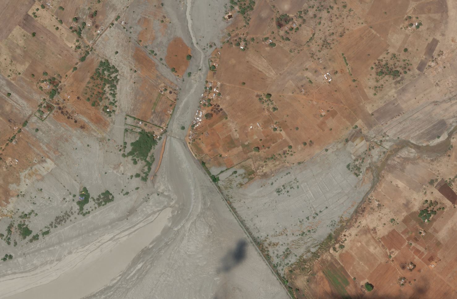
The impact of the mine waste plume from the Williamson Mine tailings dam failure. Planet Labs SkySat image, copyright Planet Labs, used with permission. Image captured 9 November 2022 at 11:21 UT.
.
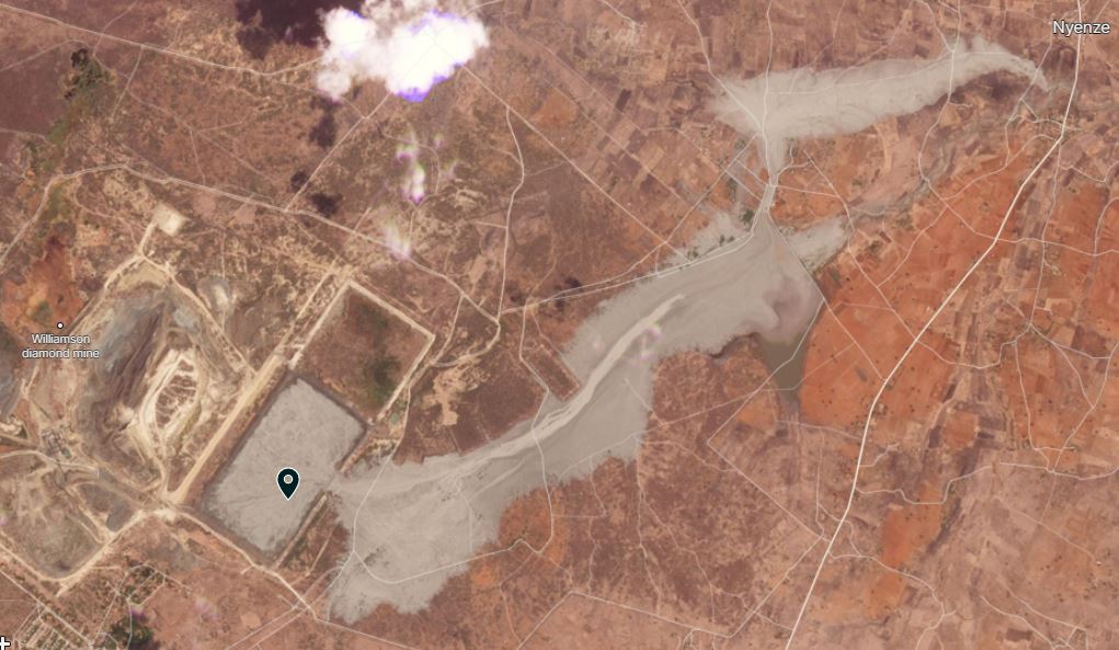
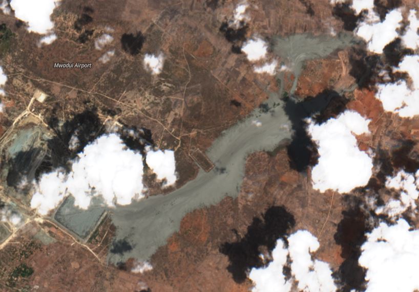
Further to the northeast there is another set of properties affected by the tailings:-
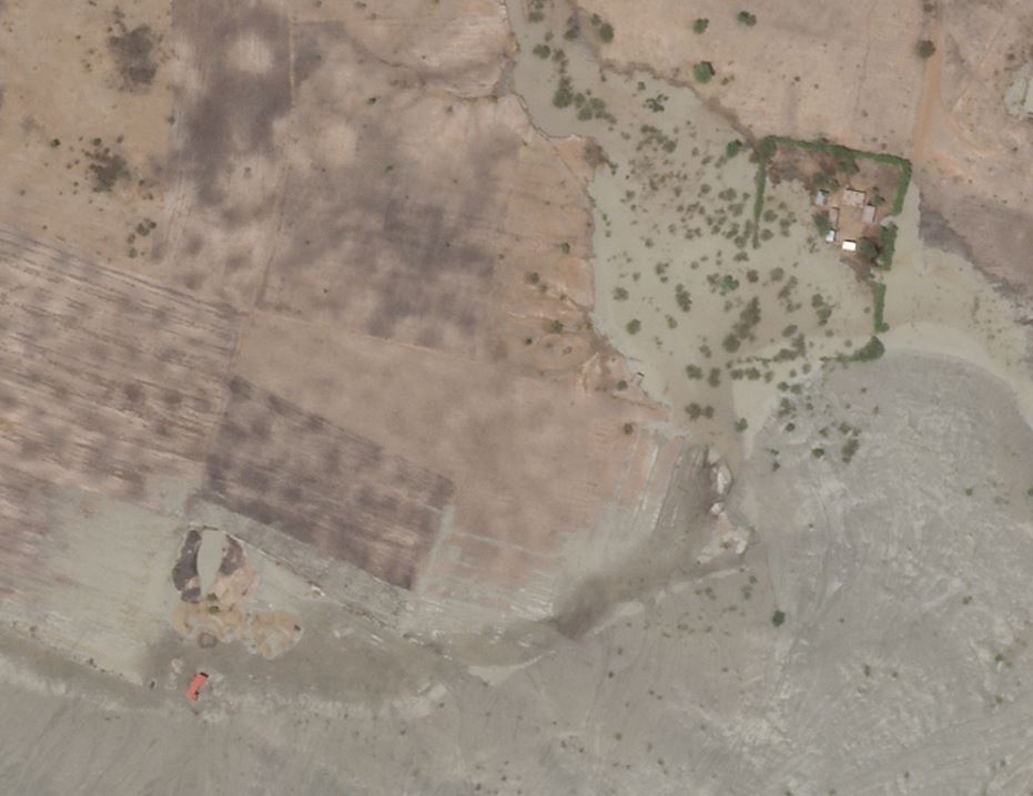
The impact of the mine waste plume from the Williamson Mine tailings dam failure. Planet Labs SkySat image, copyright Planet Labs, used with permission. Image captured 9 November 2022 at 11:21 UT.
.
For these households the impact of the mine waste will have been devastating. Reuters reports that 13 households have been displaced, whilst mining operations have been suspended for three months pending an investigation into the causes of the disaster. The incident is being investigated by the National Environment Management Council (NEMC) in Tanzania. Petra Diamonds itself has a statement on its website dated 10 November 2022, which includes this:
Impact on the environment and local community
From an initial assessment, supported by the use of satellite imagery, the main portion of the tailings have been contained by the New Alamasi water dam which sits within the Mine Lease Area to the north east of the TSF. A portion of tailings has flowed around the dam into a tributary to the north of the New Alamasi water dam. Flow below the dam consisted mainly of water and was largely contained by the topography.
[Williamson Diamonds Limited – WDL] WDL is working closely and collaboratively with local, Regional and National authorities to assess the environmental damage and to put in place and implement remediation plans as soon as possible. WDL and Petra appreciate the prompt response and assistance that has been provided by these authorities.
A total of 13 dwellings have been affected and the emergency response teams’ immediate priority has been to provide accommodation and humanitarian aid to those affected. A socio-economic survey has been initiated, supported by an external social impact specialist, to determine additional social impact. Extensive and ongoing engagement with communities will continue to take place, together with the Government, to ensure that key stakeholders are kept appraised of WDL’s response, including planned remediation activities.
I will leave it to the reader to judge as to whether they feel that this is an adequate response to an accident of this scale.
.
Reference and acknowledgement
Thanks to Rob Simmon at Planet Labs for acquiring and posting the image.
Planet Team (2022). Planet Application Program Interface: In Space for Life on Earth. San Francisco, CA. https://www.planet.com/
14 November 2022
El Molino: a very large landslide in Colombia
El Molino: a very large landslide in Colombia
On 10 November 2022 a large landslide occurred at El Molino in Villa Caro, Norte de Santander in Colombia. Landslides are increasingly common in Colombia, but this is an unusually large event. Caracol has an article in Spanish about the landslide, whilst Semana has this before and after image of the site:-
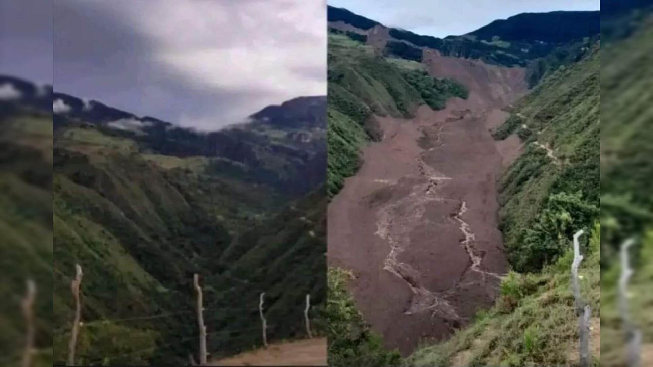
Before and after image of the landslide at El Molino in Colombia. Image from Semana.
.
It is very difficult to appreciate the scale of this landslide from photographs, but Noti Cucuta has tweeted this helicopter footage of the aftermath of the event:-
Grave desastre en Villa Caro deja cinco personas desaparecidas. pic.twitter.com/muIWVES8OK
— Noti Cúcuta (@noticucuta) November 12, 2022
.
There is also another video that has been tweeted by Diario La Opinión:-
#Atención #Video | En el sobrevuelo que hizo la Gobernación de Norte de Santander, se ve el estrago de la temporada invernal que afecta a los habitantes de Villa Caro.
Más info en: https://t.co/FGSSTs7IlP pic.twitter.com/KzSGRAJLeI— Diario La Opinión (@laopinion_col) November 11, 2022
.
And Segunda División del Ejército Nacional has a further helicopter video, which shows the long runout of the landslide:-
En horas de la tarde acompañamos a @GoberNorte y al equipo de gestión del riesgo, en un sobrevuelo sobre la zona afectada por la ola invernal en Villa Caro, para evidenciar la magnitud de lo ocurrido y apoyar a las autoridades en las labores humanitarias de emergencia. pic.twitter.com/um6KqRTUl5
— Segunda División del Ejército Nacional (@Ejercito_Div2) November 12, 2022
.
The landslide was triggered by prolonged heavy rainfall. It has resulted in 28 families being rendered homeless, and five people from a single family are reported to be missing, presumed to have been killed.
This landslide is quite reminiscent of the 16 December 2017 Villa Santa Lucia landslide in Chile. I will need to use satellite imagery to understand it properly. The landslide was captured on a Planet Labs image on 11 November 2022, so this will be possible in the coming days. The crown of the landslide is at 7.949, -73.025. It has a total runout distance (crown to toe) of about 5 km.
I will provide more details in the coming days.
10 November 2022
High-resolution SkySat imagery of the Williamson Mine tailings dam breach
High resolution SkySat imagery of the Williamson Mine tailings dam breach
My good friends at Planet Labs have very kindly captured a high resolution SkySat image of the aftermath of the major Williamson Mine tailings dam breach in Tanzania. I will post further images over the next few days. To start off, the image below shows the site of the breach itself:
The breach that caused the Williamson Mine tailings dam failure. Planet Labs SkySat image, copyright Planet Labs, used with permission. Image captured 9 November 2022 at 11:21 UT.
The breach is large as I noted yesterday. It appears that some of the original tailings wall material, including intact blocks, have been deposited on the downstream edge of the breach, especially on the south side. There appears to be a step in the tailings at the site of the breach, suggesting a lower layer of denser tailings. This indicates that further releases could occur in rainfall.
The tailings that have escaped appear to have been very fluid – note the flow patterns in the sediments.
I can see so signs of any works occurring at the site to manage further releases. Indeed, there are no vehicles or people visible in the image, as far as I can tell.
The SkySat image has also captured the downstream impacts of the tailings dam breach. This is the tailings plume:-
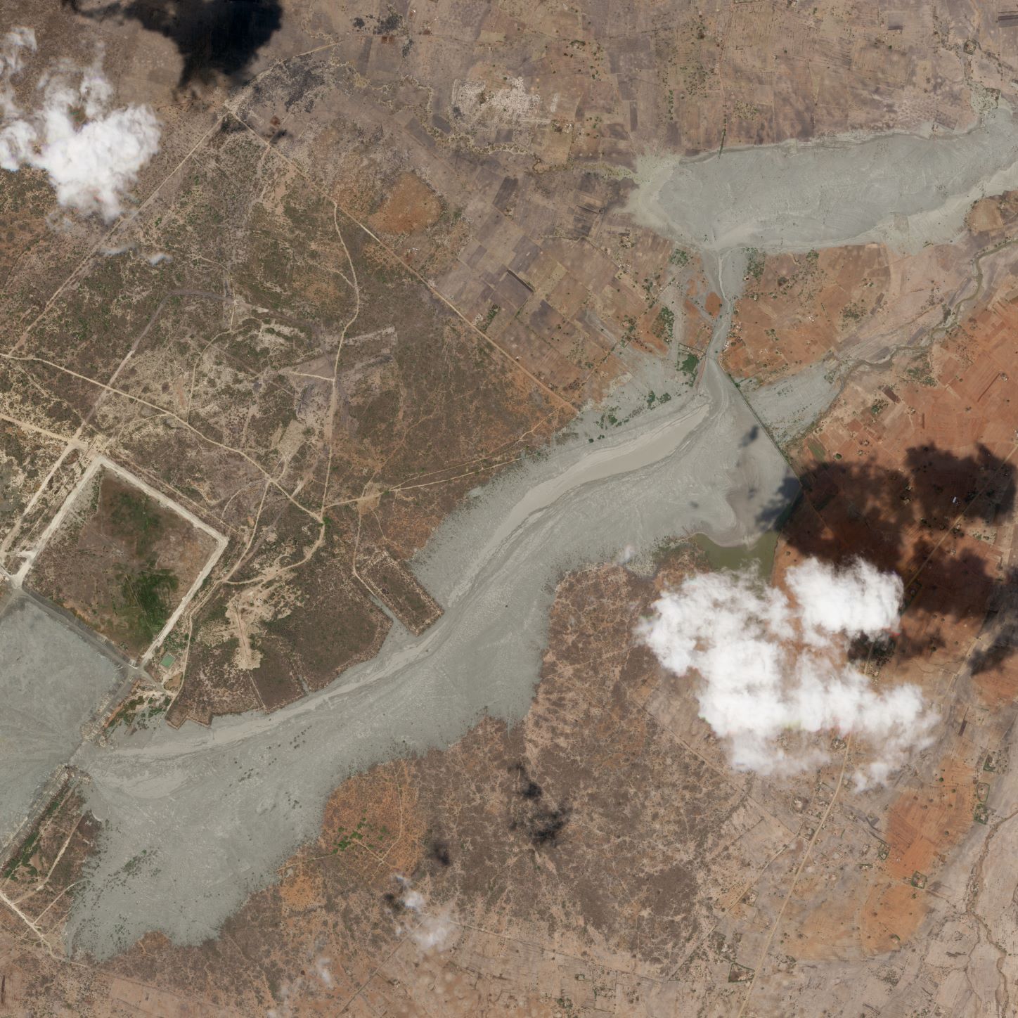
The mine waste plume from the Williamson Mine tailings dam failure. Planet Labs SkySat image, copyright Planet Labs, used with permission. Image captured 9 November 2022 at 11:21 UT.
The images show that the plume hit a water retention structure downstream from the mine, filling the reservoir. Some tailings appear to have overtopped, but most have followed the spillway to the north, inundating the basin of an incised channel. I will try to post further imagery of this area in the coming days.
Reference and acknowledgement
Thanks to Rob Simmon at Planet Labs for acquiring and posting the image.
Planet Team (2022). Planet Application Program Interface: In Space for Life on Earth. San Francisco, CA. https://www.planet.com/
9 November 2022
Planet Labs image of the Williamson Diamond Mine tailings dam failure
Planet Labs image of the Williamson Diamond Mine tailings dam failure
Clear weather yesterday has allowed Planet Labs to capture a new PlanetScope image of the site of the tailings dam failure at the Williamson Diamond Mine earlier this week:–
Planet Labs image of the Williamson Diamond Mine tailings dam failure in Tanzania. Image copyright Planet Labs, used with permission, dated 8 November 2022.
.
The image shows a large (c.150 m) breach in the eastern wall of the facility, confirming initial reports. This is a very substantial breach. It is also noticeable that there has been further flow of tailings from the TSF since the image that was captured yesterday, with wet mine waste through the middle part of the plume. There is an urgent need to prevent any further escapes.
Planet Labs image of the plume from the Williamson Diamond Mine tailings dam failure in Tanzania. Image copyright Planet Labs, used with permission, dated 8 November 2022.
.
The plume extends for a thalweg distance of about 7.5 km from the site of the breach at the Williamson Diamond Mine. The imagery lacks the resolution needed to see whether the tailings have caused substantial damage to the rivers below this point. Of course there is a danger that the tailings will remobilise in future heavy rainfall events.
It is notable that there is very, very little online about this large tailings dam failure.
.
Reference
Planet Team (2022). Planet Application Program Interface: In Space for Life on Earth. San Francisco, CA. https://www.planet.com/
8 November 2022
Another tailings dam failure: the Williamson Mine in Tanzania
Another tailings dam failure: the Williamson Mine in Tanzania
I’m sad to report this morning that there has been yet another significant tailings dam failure, this time at the Williamson Mine in Tanzania (the location is -3.525, 33.620). There are brief reports in a number of mining related journals, including African Mining Review and Mining Weekly The reports indicate that the eastern wall of the tailings storage facility has been breached.
This is a Google Earth image of the site, which is a diamond mine owned by Petra Diamonds (75%) and by the Government of Tanzania (25%):-
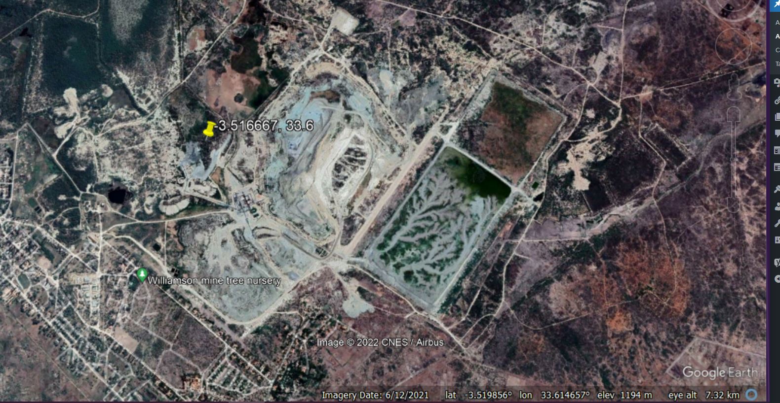
Google Earth image of the Williamson Mine in Tanzania. Note the tailings storage facility on the centre right of the image. Reports indicate that the eastern wall breached.
.
Planet Labs captured an image of the site yesterday (7 November) at 07:45 UTC. The image is partially cloudy, especially over the TSF itself, but a large plume of tailings can be seen:-
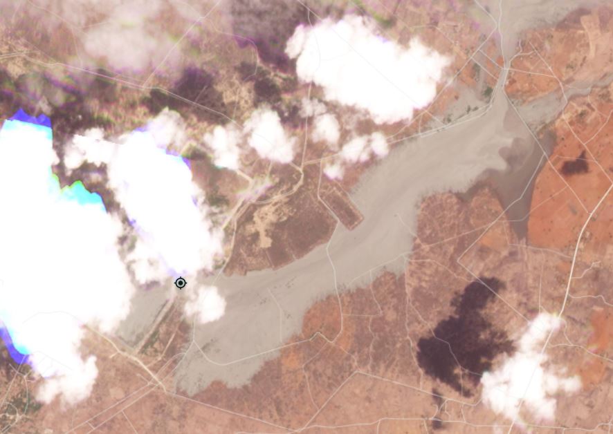
Planet Labs image of the site of the tailings dam breach at the Williamson Mine in Tanzania. Image copyright Planet Labs, used with permission, dated 7 November 2022.
.
I have place the marker at the approximate position of the beach in the wall of the TSF. The plume of tailings has flowed initially to the southeast and then towards the northeast. It appears that some mine waste has entered the local rivers, but the amount in unclear. The plume is over 6 km long and has a maximum width of about 1.2 km. A very rough estimate has a surface area of the plume at about 4.7 km².
There is a Sentinel 2 image of the site, also captured yesterday:-
Sentinel 2 image of the site of the tailings dam breach at the Williamson Mine in Tanzania. Image accessed via the EO Browser.
.
This provides a slightly better image of the breach in the TSF wall. As yet I can find no images of the event on the ground.
This is the second major tailings dam failure in Africa in two months, following the Jagersfontein event on 11 September 2022 in South Africa.
Interestingly, Wikipedia reports that the mine was mothballed in April 2020. The owners offered it for sale in September 2021, indicating that it was permanently closed. However, Investors’ Chronicle reported last month that production had restarted.
.
Reference
Planet Team (2022). Planet Application Program Interface: In Space for Life on Earth. San Francisco, CA. https://www.planet.com/
7 November 2022
The May 2022 landslide cluster at Dima Hasao district in Assam, India
The May 2022 landslide cluster at Dima Hasao district in Assam, India
In the period between 11 and 18 May 2022 Dima Hasao district in Assam, India was badly affected by a period of exceptional early monsoon rainfall. The impact of multiple landslides was widely reported, including some remarkable images of the burial of trains at New Haflong railway station. Nezine has an excellent set of images of the aftermath by Anup Biswas:-
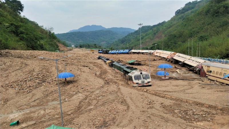
Trains buried by landslides at New Haflong station on 14 May 2022. Image by Anup Biswas via nezine.com.
.
An article just published in the journal Landslides (Roy et al. 2022) provides a very useful initial analysis of this event. The authors have used satellite imagery to map the landslides. In total they have identified 5,178 landslides triggered by this rainfall event. This is their map of this remarkable landslide cluster:-
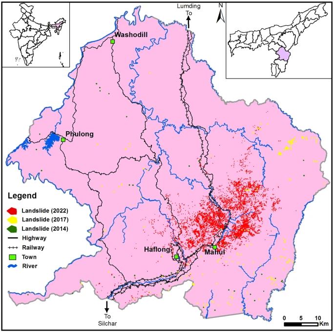
The distribution of landslides triggered by heavy rainfall in May 2022 in the Dima Hsao district of India, together with landslides from 2014 and 2017. Map by Roy et al. (2022).
.
New Haflong Station is located at 25.147, 93.033. The rainfall event that triggered the landslides is quite interesting. In May 2022 Dima Hasao district received 540 mm of rainfall, based on satellite data analysis by Roy et al. (2022), including 156 mm on 11 May. The map above shows remarkable clustering of landslides, implying that this area suffered particularly intense precipitation that might not have been captured by the satellite data.
At New Haflong Station itself, Roy et al. (2022) have identified multiple landslides on the valley walls that coalesced to form channelised debris flows. Their simulations indicate peak flow velocities of 42 m/sec and simulated maximum flow depths of about 8 metres. These are exceptionally high values.
There is clearly an urgent need to address the vulnerability of New Haflong Station to landslides.
.
Reference
Roy, P., Martha, T.R., Vinod Kumar, K. et al. 2022. Cluster landslides and associated damage in the Dima Hasao district of Assam, India due to heavy rainfall in May 2022. Landslides. https://doi.org/10.1007/s10346-022-01977-6
3 November 2022
Pierreville: an interesting landslide in Quebec, Canada
Pierreville: an interesting landslide in Quebec, Canada
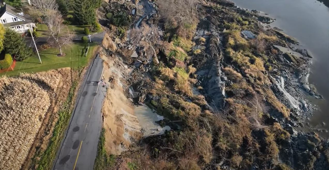
On 1 November 2022 at about 3:30 am local time an interesting landslide occurred at Pierreville in Quebec, Canada. There is an excellent drone video of the aftermath of the landslide on Youtube:-
.
I think the location is 46.079, -72.846, although this needs to be confirmed. This image is from the video:-
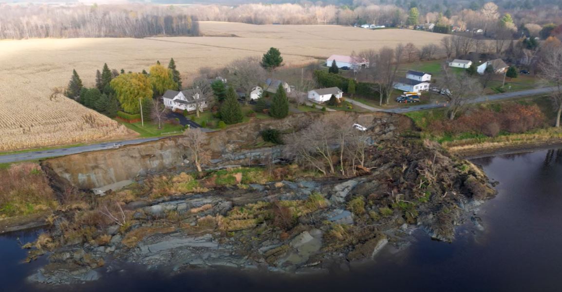
The 1 November 2022 landslide at Pierreville, Canada. Still from a video posted to Youtube.
.
La Ronge Northerner has an article about the event (with what I take to be a surprising typo, if you can find it!). No-one was killed by the landslide, and the images indicate that the houses have not been damaged so far. A van driving along the road crashed into the landslide, the driver survived but was treated for shock.
The landslide is a slump/spread, with some rotational component. This still from the video shows the rather complex form of the deposit:-
The aftermath of the 1 November 2022 landslide at Pierreville, Canada. Still from a video posted to Youtube.
.
Note the materials involved in the landslide, which are clearly fine-grained.
The timing of the failure is intriguing, as there had been no heavy rainfall and the river does not appear to be high or in flood. There is Google Street View imagery of the site from 2014 which shows a fair amount of cracking and some repairs to the road in the area that failed:-
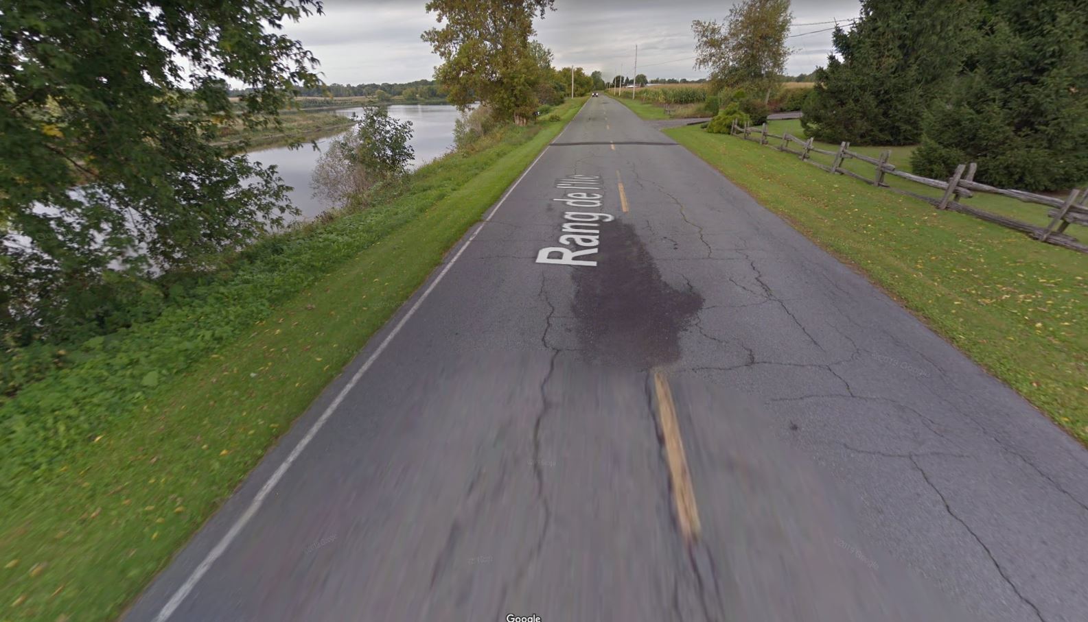
Google Street View imagery from 2014 showing the site of the 1 November 2022 landslide at Pierreville, Canada.
.
This is not a smoking gun in isolation however – the cracking and repairs could have alternative explanations.
Geotechnical testing will now be needed to determine whether the houses affected will be safe to occupy in the long term, and to plan the remediation of the site to reopen the road. A key priority will be to identify the likelihood of retrogression of the headscarp.
2 November 2022
The role of atmospheric pressure in landslide triggering
The role of atmospheric pressure in landslide triggering
A few years ago there was considerable surprise when high resolution monitoring of the Slumgullion landslide in the United States found that atmospheric pressure played a role in controlling movement. There has been some interest in this behaviour since – for example, it has not been clear as to whether Slumgullion is an exception. Is the stability state so marginal in this case that tiny fluctuations in inter-grain pressure affect stability – or has this type of response been missed because of the low resolution of most monitoring?
A new open access paper in the journal Natural Hazards and Earth System Science (Pelascini et al. 2022) has investigated this phenomenon in more detail. The test site was in Taiwan, which I have always considered to be the world’s greatest landslide laboratory (as well as an amazing place to visit). The weather conditions that drive the investigation were typhoons, which are really interesting because they bring both extreme rainfall and comparatively large fluctuations in atmospheric pressure. The researchers have used a model to explore the slope response to changes in pressure, driving by measured changes in pressure from the typhoon events.
The diagram below, from Pelascini et al. (2022), illustrates the potential drivers of the landslides. The graph on the left shows peak rainfall intensity for a range of typhoons in the study area plotted against the atmospheric pressure drop, with three key typhoons highlighted. On the right, the time series for the change in atmospheric pressure and the rainfall is shown for the three typhoons and a synthetic event.
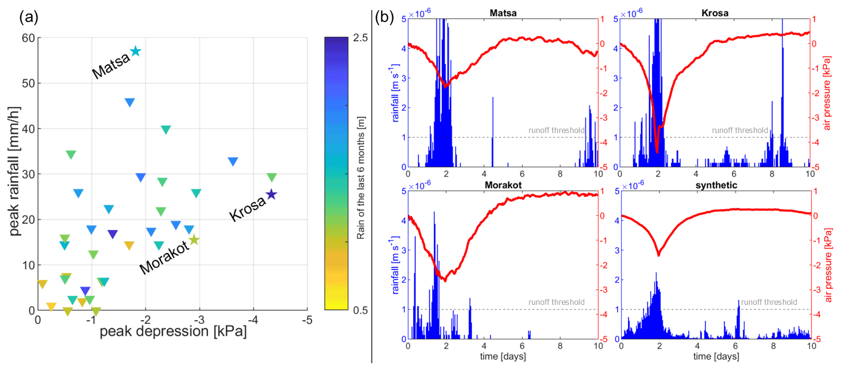
(From the paper): (a) Typhoons over Taiwan sorted as a function of their maximum rainfall intensity and atmospheric pressure drop. The hydrological context is represented by the colour scale, showing the cumulated rainfall over the 6 months before the event. (b) Time series of rainfall and atmospheric pressure changes of the three typhoons and the synthetic event created from the average of every typhoon. Figure from Pelascini et al. (2022).
.
When this data was fed into the landslide model, interesting results merged. Not surprisingly, the rainfall infiltration was able to induce large changes in pore water pressure, which are of course important for stability. However, the effects were delayed by hours or even days due to the time required for pressure change to diffuse through the soil. On the other hand, the atmospheric pressure changes were much smaller, but the impacts on the soil were instantaneous.
Pelascini et al. (2022) have made an interesting observation in that typhoons occur in or after the wet season in Taiwan, when slopes are already saturated. I would be interested in understanding the data that supports this key assertion. But, if so, then something else must finally trigger the landslides in the typhoon event. Their modelling suggests that this might be the atmospheric pressure drop.
This is a fascinating result. Of course, in the real world, this is a complex phenomenon, and the authors are careful to note the need for more research. In a typhoon, triggering will be controlled at the first level by rainfall – the slope will not fail until the pore water pressures are high – but Pelascini et al. (2022) have highlighted that the factor that might finally induce failure is the reduction in atmospheric pressure as the eye of the storm passes over or close to the slope. In a sense, the atmospheric pressure is the straw that breaks the camel’s back.
There is one other observation that is interesting in the paper. The models suggest that storm triggered landslides tend to initiate at the toe of the slope. This has been postulated previously, but it is good to see further evidence.
Overall, I think that this study is a really fascinating contribution, providing further evidence of the complexity of landslide initiation. It should be the trigger (if you’ll excuse the pun) for a range of studies involving slope scale monitoring and modelling, as well as landscape-scale investigations. I shall look forward to seeing further work in this area in the coming years.
.
Reference
Pelascini, L., Steer, P., Mouyen, M., and Longuevergne, L. 2022. Finite-hillslope analysis of landslides triggered by excess pore water pressure: the roles of atmospheric pressure and rainfall infiltration during typhoons. Natural Hazards and Earth System Sciences, 22, 3125–3141, https://doi.org/10.5194/nhess-22-3125-2022.
1 November 2022
Planet Labs images of the Kusiong landslides in the Philippines
Planet Labs images of the Kusiong landslides in the Philippines
Inquirer.net has eyewitness accounts of the devastating 27 October 2022 Kusiong landslides in the Philippines, triggered by Severe Tropical Storm Nalgae (Paeng).
“…an avalanche of huge rocks and boulders with mud cascaded quickly toward the relocation site where the Teduray indigenous peoples had been living since 2021. “We heard thundering sounds and people yelling for help as mud and rocks entered our house,” recalled Mercy, 55, a survivor, in an interview on Sunday afternoon. “I could not remember what happened next” or how she and her children survived the rock avalanche, said Mercy, who, along with her children, were awakened from their deep sleep by the thunderous sound...Many of the survivors suffered from leg and foot injuries since the floods and rocks literally were running after them as they fled, said the village chief.
Meanwhile, Planet Labs has captured an image of the affected area, which powerfully demonstrates what happened. This is a lower resolution (but still excellent) PlanetScope image, captured on 31 October 2022:-
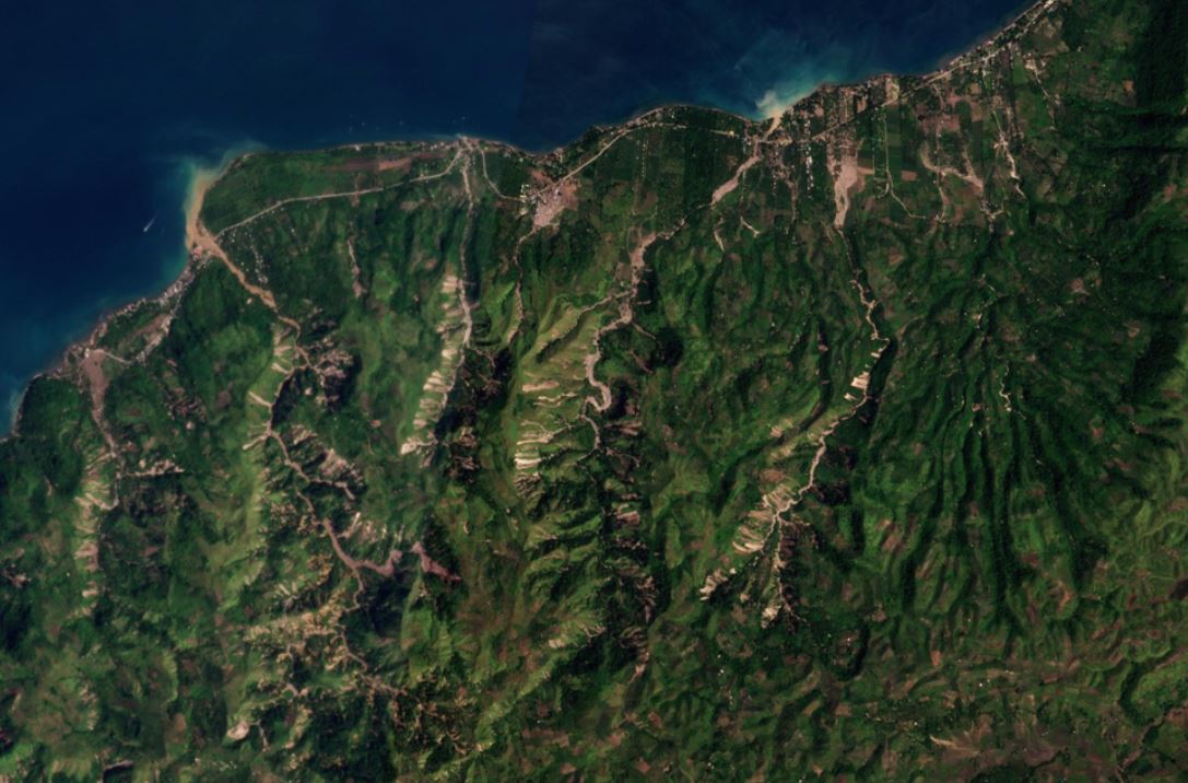
The aftermath of the Kusiong landslides. Planet Labs PlanetScope image, captured on 31 October 2022. Copyright Planet Labs, used with permission.
.
I have annotated this image below to highlight the main areas:-
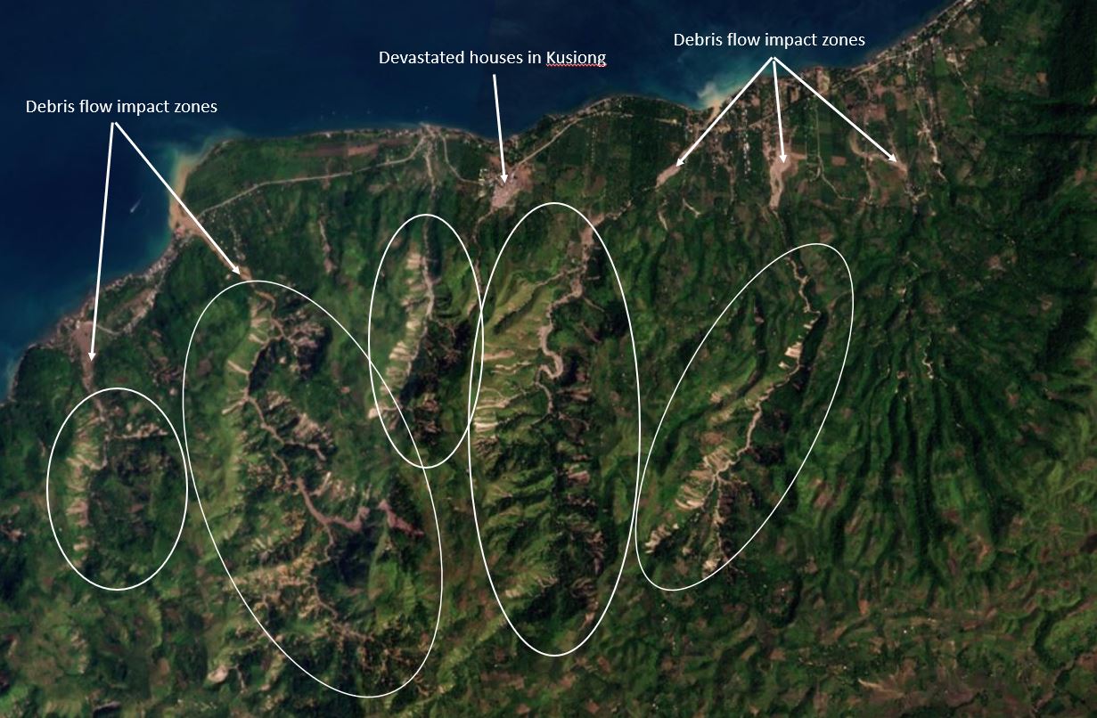
Annotated satellite image of the aftermath of the Kusiong landslides. Planet Labs PlanetScope image, captured on 31 October 2022. Copyright Planet Labs, used with permission.
.
I have highlighted in white the main areas of landslides across five catchments. In these zones the density of landslides is high. These appear primarily to be shallow landslides that have merged in the channels to become channelised debris flows, which have hit the communities.
The biggest single impact of the Kusiong landslides occurred in Datu Odin Sinsuat, which I believe is the site of the devastated houses that I have highlighted in the image. There are 31 confirmed fatalities at this location, with a further seven at the nearby Datu Blah Sinsuat. This is a Planet Labs image of the site of Datu Odin Sinsuat:-
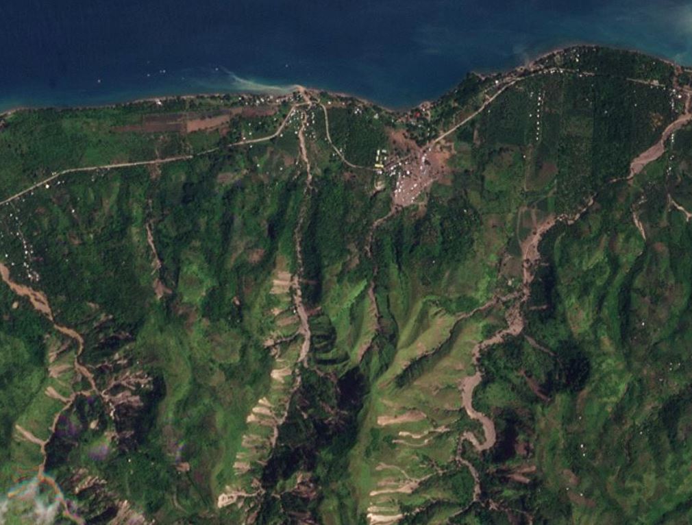
The aftermath of the Kusiong landslides in the area of Datu Blah Sinsuat. Planet Labs PlanetScope image, captured on 30 October 2022. Copyright Planet Labs, used with permission.
.
The catchment upstream of Datu Blah Sinsuat is comparatively small, and the occurrence of landslides is rather less than in adjacent catchments. To me this highlights two things – first, the disaster is primarily the result of the vulnerability of the community, and second the hazard itself might have been affected by the timing of the shallow landslides within the small catchment, perhaps generating a large pulse of debris as described by the eyewitnesses.
These types of landslides are usually caused by extremely intense rainfall (a cloudburst type event). It seems likely to me that this comparatively small part of Maguindanao del Norte province was probably hit by a pocket of exceptional rainfall within the main tropical storm.
Of course the Kusiong landslides need a proper scientific investigation, including mapping from imagery and fieldwork, and analysis of any available rainfall records.
.
Reference and acknowledgements
The images are from the wonderful people at Planet Labs.
Planet Team (2022). Planet Application Program Interface: In Space for Life on Earth. San Francisco, CA. https://www.planet.com/
31 October 2022
Kusiong village in the Philippines: perception vs reality for hazard events
Kusiong village in the Philippines: multiple landslide fatalities
On Thursday 27 October 2022 heavy rainfall associated with Severe Tropical Storm Nalgae (known locally as Severe Tropical Storm Paeng) triggered a large landslide in Kusiong village in southern Maguindanao province in the Philippines. To date 20 bodies have been recovered, but there are concerns that 80 to 100 more people may have lost their lives. The village is located at 7.142, 124.088.
GMA News has this image of the aftermath of the landslide – the level of damage appears to be very serious:-
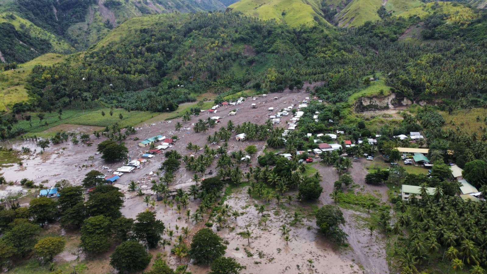
The aftermath of the landslide at Kusiong on the Philippines. Image from BARMM FB / GMA News.
.
Several news agencies are reporting that this disaster arose in part because of a dangerous interaction between perceptions of different hazards. ABC News provides a good overview:-
In August 1976, an 8.1-magnitude earthquake and a tsunami in the Moro Gulf that struck around midnight left thousands of people dead and devastated coastal provinces in one of the deadliest natural disasters in Philippine history.
Lying between the Moro Gulf and 446-meter Mount Minandar, Kusiong was among the hardest hit by the 1976 catastrophe. The village never forgot the tragedy. Elderly villagers who survived the tsunami and powerful earthquake passed on the nightmarish story to their children, warning them to be prepared.
“Every year, they hold drills to brace for a tsunami. Somebody was assigned to bang the alarm bells and they designated high grounds where people should run to,” Sinarimbo said. “Villagers were even taught the sound of an approaching big wave based on the recollection of the tsunami survivors.”
“But there wasn’t as much focus on the geo-hazards on the mountainside,” he said.
On the day of the disaster, the people of Kusiong feared a storm surge, understandably, and so sheltered in a church on higher ground. They were not prepared for a mudslide from the flanks of Mount Minandar, which has caused such high levels of loss.
This is a salutary tale. I have seen on multiple previous occasions this tendency to focus on one hazard at the exclusion of others, and in particular to exclude landslide hazards when considering tsunami / storm surge and/or earthquakes.
Kusiong village is a tragic reminder of why a multi-hazard perspective is always needed.
 Dave Petley is the Vice-Chancellor of the University of Hull in the United Kingdom. His blog provides commentary and analysis of landslide events occurring worldwide, including the landslides themselves, latest research, and conferences and meetings.
Recent Comments