
28 October 2022
The Duffey Lake landslide: old logging roads and slope failures
Posted by Dave Petley
The Duffey Lake landslide: old logging roads and slope failures
On 15 November 2021 a series of landslides occurred during a period of heavy rainfall in British Columbia, Canada. I wrote about those landslides at the time. Substantial damage was caused to both Highway 1 and Highway 99. In the most deadly failure, now known as the Duffey Lake landslide, five people were killed and substantial damage was caused to Highway 99.
The Canadian media organisation CBC has a piece that explores the causes of these landslides, highlighting the role of old resource (logging) roads on the hillside above Highway 99. There is a very interesting video, which last about 10 minutes, in the article. It includes this diagram about the two landslides triggered in the Duffey lake area:-
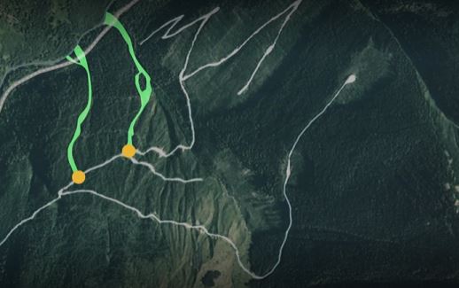
The 2021 landslides at Duffey Lake in BC, Canada. Still from a video produced by CBC.
.
The landslides at Duffey Lake appear to have originated from the sites of an old logging road high up on the hillsides. This road was constructed in the 1960s, and used through to the mid-1990s but then abandoned. The location is at about 50.473, -122.226. I have indicated the approximate location of the crown of the landslide and the impact point on Highway 99 on the Google Earth image below:-
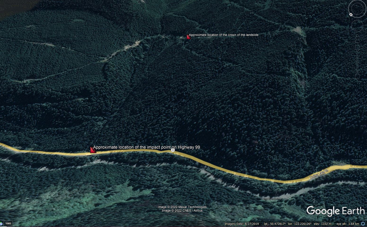
Google Earth image showing the approximate location of the Duffey Lake landslide.
.
The site was investigated by geologist Pierre Friele. His findings are described in an article on the Maple Ridge-Pitt Meadows News website:-
The problem, he said, was in the area of a switchback. Two older, small landslides had left debris resting on the road below the switchback, plugging a ditch. The water then ran down the road instead of crossing over the road and going down a stable slope.
It was the diversion and concentration of water from the road that triggered the initial failures high above Highway 99. Given the steepness of the terrain, they were able to turn into a major landslides that impacted the main road at the foot of the slope.
Interestingly, even the 2019 Google Earth imagery appears to show a couple of small failures on the resource road in the area of the landslide source:-
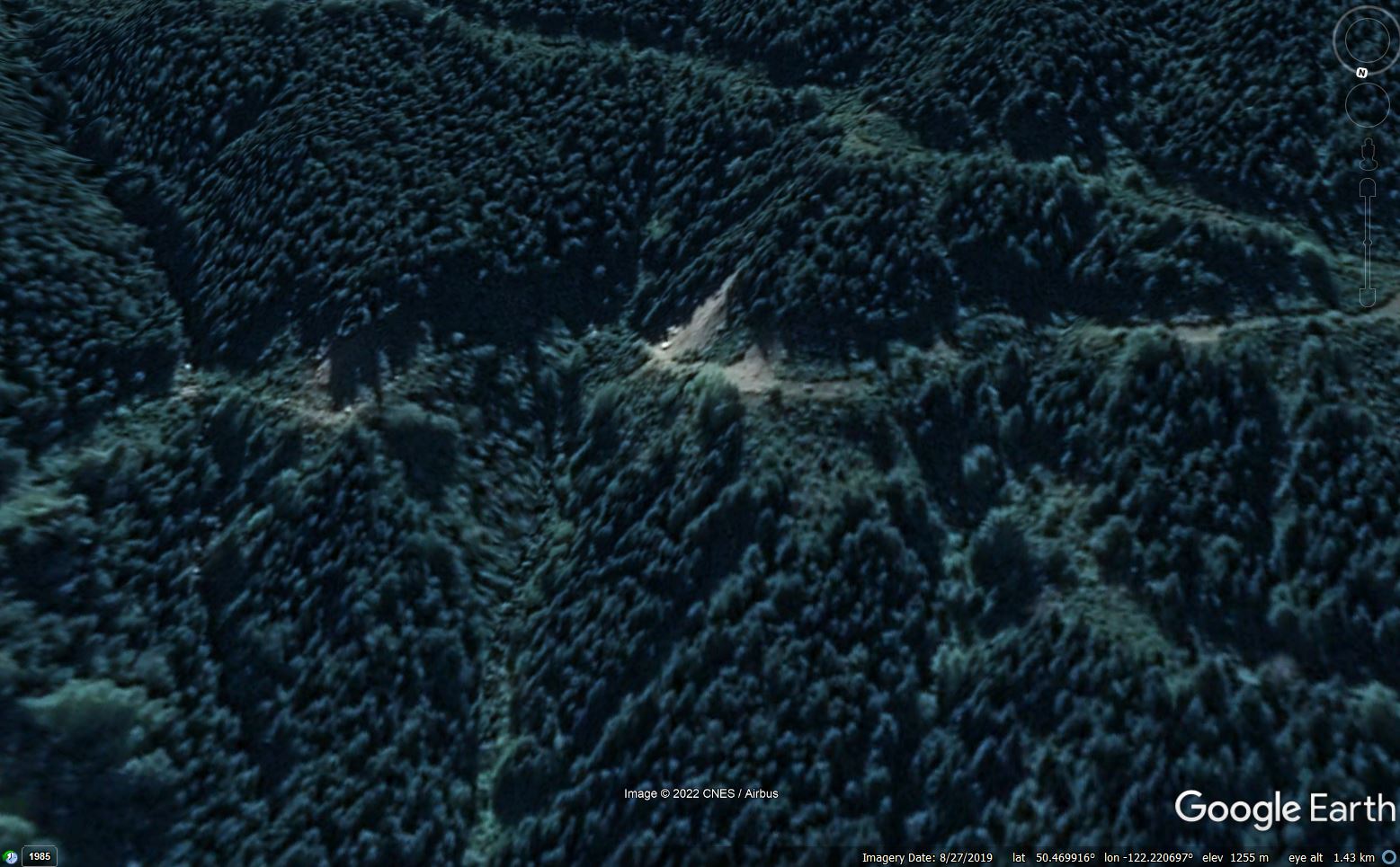
Google Earth image showing small landslides on the resource road close to the source of the Duffey Lake landslide.
.
I have written extensively about poor quality road construction, and its impact on slope instability. In the case of these resource (logging or mining) roads in Canada, it is poor maintenance, or a failure to properly deactivate the roads when they are no longer needed, that is causing the problems.
The CBC article highlights that these roads pose a substantial long term hazard in Canada. It is estimated that there are over 1.5 million kilometres of resource roads – British Columbia alone has 600,000 km of these roads.
 Dave Petley is the Vice-Chancellor of the University of Hull in the United Kingdom. His blog provides commentary and analysis of landslide events occurring worldwide, including the landslides themselves, latest research, and conferences and meetings.
Absolutely. Poorly controlled or concentrated runoff, and placement of fill has long been an issue here in NorCal. Things have changed for the better though, through a combination of forester education and regulatory enforcement.
We had a pair of El Niño winters back to back 95-96 and 96-97. Anything that could fail did. It was almost always poor drainage like this. Failure of side cast fill dumped on unprepared slopes was a close second.
I worked for geotech engineers on BC forest roads, often in drainage remediation, and in BC Gov as an environmental inspector, and I’ve seen firsthand how incomplete road deactivation is widespread across BC. One frustrating example is a major salmon resource river valley in the mountains that had many slides from poor deactivation practices, and then later became a Gov poster child for 10 run of river hydro projects in that one watershed. Resulting in a continued degradation of endangered salmon populations, despite First Nations objections. A solution means a complete overhaul of “professional reliance” and a reversal of regulatory capture. I expect a few high profile triage projects and business as usual for the balance.
My interest in the handing over of areas to be healed by indigenous is doomed if those in power and greed won’t listen to advice.
They are also the cause of these lands left to suffer. Publishing these excellant emails with science involved answer ongoing questions. Thank you all for these insights.
I am an armchair science-follower.
Such a sad situation. I am so sorry for those who died in these catastrophic floods. Thanks for your attention to this situation. We will do better. We must.
In the northern California watersheds that are listed as sediment impaired, rural roads are listed as the highest contributors to anthropogenic sediment loads. Things are changing for the better, however, given the tens of thousands of miles of private, county, and logging roads we have there is still a lot of outreach, education, funding, and remediation to be done.
There is so much work to do in BC, Canada in forest management! These logging companies have left pristine lakes, rivers filled with logs from improper management to landslides.
Canada needs to spend $ PDQ to clean up dead fall, especially near electric lines, transformers. Whenever our sun creates geomagnetic storms, the northern latitudes are most suseptable. These fires are not going to stop anytime soon. In the interim, the US receives most of the toxic air from these fires!
GET TO WORK!!