
16 November 2021
Landslides and road damage from an atmospheric river event in British Columbia
Posted by Dave Petley
Landslides and road damage from am atmospheric river event in British Columbia
British Columbia, in western Canada, suffered an atmospheric river rainfall event on Sunday and Monday that caused extensive damage and many landslides. The full picture will not become clear until later this week, but levels of damage to the road network look to be high in places.
Live Journal has a good gallery of images of the aftermath, including this picture of a landslide on Highway 1 between Agassiz and Hope:-
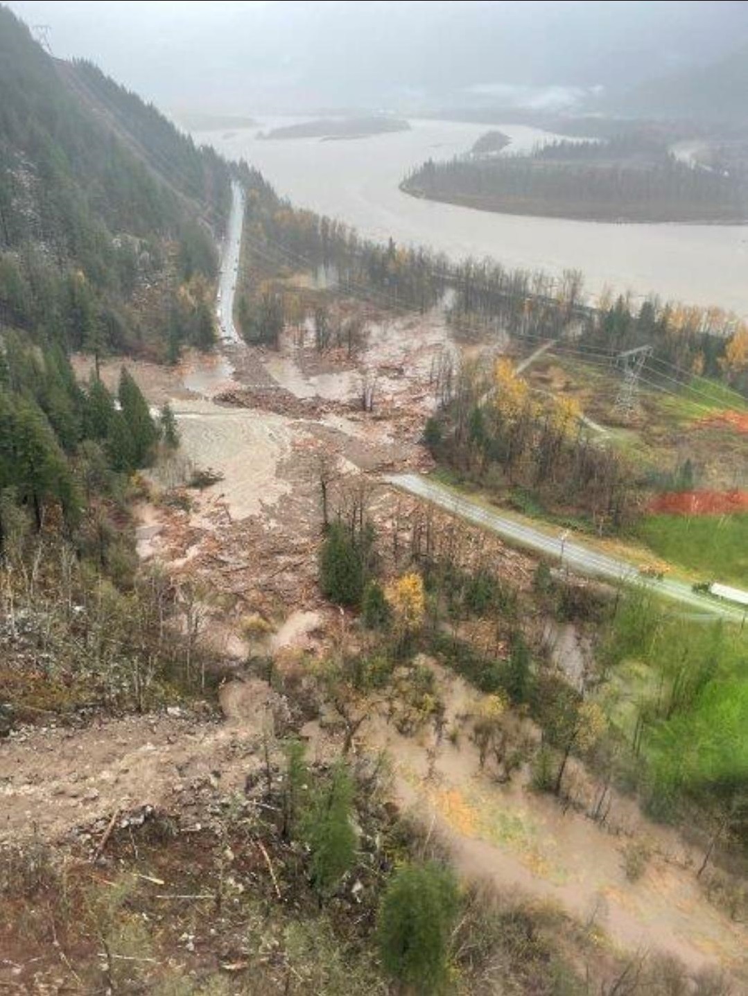
A landslide on Highway 1 between Agassiz and Hope in British Columbia. Image from Livejournal.
.
Meanwhile another landslide occurred on Highway 5 to the north of Hope:-
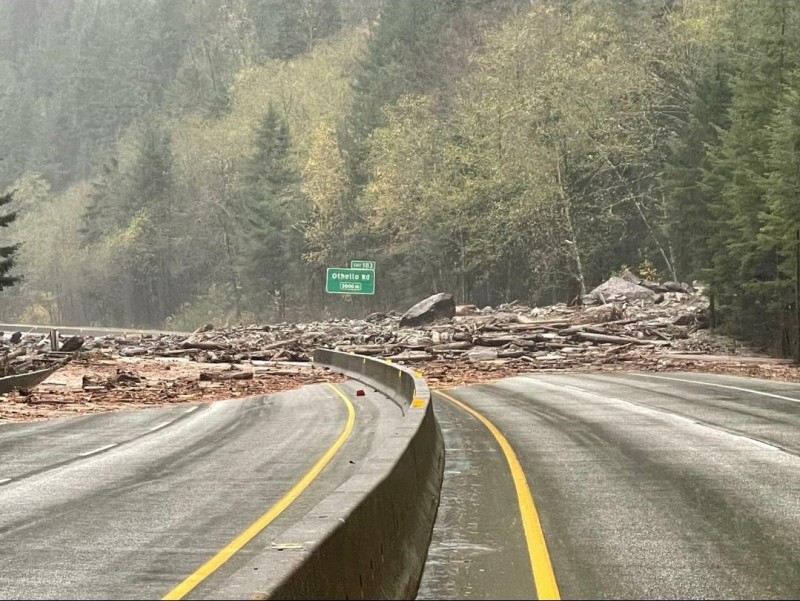
A landslide on Highway 5 to the north of Hope in British Columbia. Image from Livejournal.
.
Perhaps the most spectacular problem has occurred on Highway 1 between Lytton and Nicomen. BC Transportation has tweeted a remarkable set of images of the impact at that site:-
A look from a flyover of #BCHwy1 at Tank Hill near Lytton and Nicomen.
For the latest #BCStorm travel info, check @DriveBC's website: https://t.co/0sq39Ad5WN#TransCanadaHighway pic.twitter.com/N4zVto5vNK
— BC Transportation (@TranBC) November 15, 2021
.
That is not going to be quick job to fix. I believe that this is within the area that was affected by the large wildfire in July 2021.
And BC Highways has also tweeted images of a mudslide on Highway 99 near to Lillooet:-
#BChwy99 near #Lillooet is closed due to a mudslide between Lil'wat Pl and Texas Creek Rd for 44.6 km. Assessment in progress.
Please check https://t.co/NCVlkn102s for updates. pic.twitter.com/UAJcfR9KaH— BC Transportation (@TranBC) November 15, 2021
.
Meanwhile, the Vancouver Sun reports that as many as 275 people were trapped between two landslides on Highway 7 near to Agassiz. It has a nice graphic illustrating the scale of the issue:-
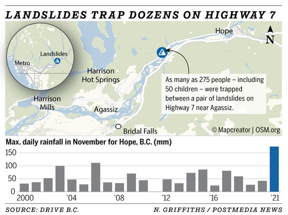
A graphic from the Vancouver Sun illustrating the scale of the issues caused by the atmospheric river in British Columbia.
.
The Vancouver Sun reports that 225 mm of rainfall was recorded at Hope in this storm.
Unfortunately it appears that there has been at least one life lost in these landslides, and the damage appears to be severe.
.
Acknowledgement
Many thanks to the various people who have provided information about this event, especially Charles Hunt and Susan DeSandoli.
 Dave Petley is the Vice-Chancellor of the University of Hull in the United Kingdom. His blog provides commentary and analysis of landslide events occurring worldwide, including the landslides themselves, latest research, and conferences and meetings.
BC’s Ministry of Transportation and Infrastructure has some good pictures on their Flickr account: https://www.flickr.com/photos/tranbc/albums/72157720143417483/
Hope Airport ended up getting almost 300mm of rain during the 2-day event. https://twitter.com/wc_hope/status/1460413548513964036?s=20
Very sadly, the RCMP has now confirmed that there has been at least one fatality from a slide that pushed cars off the road and down an embankment on the Duffey Lake Road near Lillooet. Search efforts continue with at least two other people reported missing.
The first landslide death has been reported by the RCMP. There are still a (thankfully) small number of missing people that the RCMP are seeking information on.
https://www.kimberleybulletin.com/news/lower-mainland-woman-confirmed-to-have-died-in-hwy-99-landslide-near-lillooet/
The Royal Canadian Air Force 442 Squadron evacuated all the trapped people (and dogs and cats) from between the landslides on Hwy 7 near Harrison Hot Springs yesterday afternoon and evening.
https://www.facebook.com/100064421514671/posts/262922532531795/
Unfortunately, we now have reports of fatalities in some of these events coming in.
Also, the picture you showed from near Lytton is actually Highway 1. Highway 5 is even more devastated, with multiple bridges failed and the road washed out in places.
Since then, Highway 1 farther south has flooded as the Nooksack River broke its banks and flowed north into Canada. There is currently no way to drive from Vancouver to the rest of North America, as all highways are blocked or flooded, and even the highways to the south in the US are blocked by debris flows.
The towns of Princeton and Merritt, in the interior of BC, were both substantially submerged, with the Coldwater River in Merritt going from low flow to almost double a 1/100 year flow in the span of hours.
[Thank you, I have updated the post. D.]
Not only was this a high rainfall event, it was a rain on snow event at higher elevations, dramatically increasing water flow
Here is a great article with photos taken from the International Space Station:
http://www.vancouverisawesome.com/local-news/aftermath-of-bcs-catastrophic-floods-as-seen-from-space-photos-4776728
I grew up in the area just west of Hope and Agassiz, and honestly, I am not surprised by any of this. Some might fins it interesting that the areas with some of the worse flooding were originally swamps when first settled. There are three pump stations around the valley that pump 24/7 to keep the valley from returning to its pre-settlement condition. This includes where I grew up.
The mountains on both sides of the Fraser Valley have steep channels that are highly susceptible to debris flows and other related natural hazards. In my opinion, based on the surficial geology of the Fraser Valley, there are areas that went more or less unscathed that could have been catastrophically impacted. One example would be a neighborhood in Chilliwack (my home town) that was built on a historic landslide, which reactivated not long after construction of he first homes began. There has been no sign of additional movement, based on antidotal evidence provided by members of my family who work in that neighborhood on new developments (yes I am shaking my head).
Three more fatalities recovered from slide on Hwy 99. One person still missing.
https://vancouver.citynews.ca/2021/11/20/three-men-dead-duffy-lake-landslide/
Thank you all for your pictures and information. I live in Oregon, USA. Very concerned about British Columbia. Thank you Dave Petley.