19 December 2017
The massive, catastrophic Villa Santa Lucia landslide in Chile: videos and images start to hint at the cause
Posted by Dave Petley
The Villa Santa Lucia landslide: videos and images start to hint at the cause
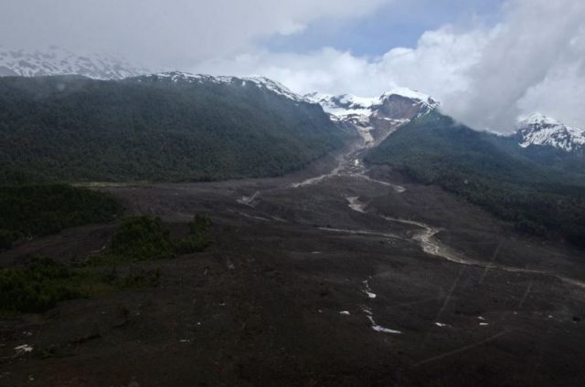
Over the course of yesterday it slowly started to become clear that the Villa Santa Lucia landslide in Chile on Saturday was an extremely large failure event. The most important image that I have seen to date is this Reuters image of the source zone of the landslide:-

Reuters image of the source of the Villa Santa Lucia landslide, via t13cl
.
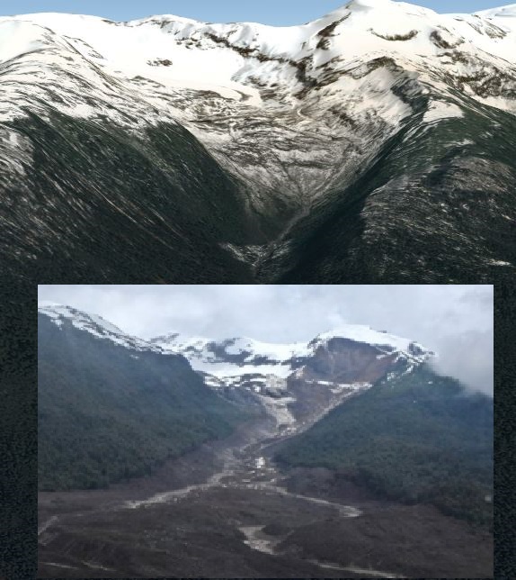
It is worth taking a closer look. In the image below I have merged the source area from the above image with the pre-failure Google Earth perspective view of the area. It is a bit clunky, but seems to indicate that this might be a massive failure of a moraine deposit at the glacier snout:-

Merged Reuters and Google Earth imagery of the source of the Villa Santa Lucia landslide
.
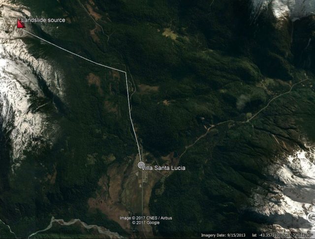
The material involved in the flow appears to be consistent with the landslide being a combination of moraine and material that it has eroded from the hillsides and the channel. This makes the landslide track about 8 km from the source to Villa Santa Maria:-

Approximate locations of the source, track and deposit of the Villa Santa Lucia landslide.
.
The best understanding of the track of the landslide comes from this Youtube video, which captures a helicopter flight up the valley from Villa Santa Lucia:-
.
The erosion of the channel suggests a very large volume flow, and the super-elevation around the bends suggest high velocities. I have found one video that captures the impact of the landslide on Villa Santa Lucia:
.
The latest news regarding the town of Villa Santa Lucia is that 12 people have been confirmed to have been killed, and a further 14 remain missing. The operation to recover the victims continues.


 Dave Petley is the Vice-Chancellor of the University of Hull in the United Kingdom. His blog provides commentary and analysis of landslide events occurring worldwide, including the landslides themselves, latest research, and conferences and meetings.
David, can I present a variation on a theme? Looking at the hills lope to the right of the moraine in the two images, I suspect there has been a rock slope failure onto the moraine. The effect would be much the same but the catastrophic undrained loading of the till would explain the rapidity and fluidity of the slide (as well as the channelisation of the flowslide).
That was my impression as well. The impressive height of the near-vertical scar above the moraine suggests to me a failure in bedrock, as does the apparent stratigraphy in the google earth image.
From analysis of images from Chilean colleagues it is apparent that the failure was the collapse of the mountain flank above the local glacier. The scale was such that it has affected the local glacier and moraine sweeping significant parts downstream. The preceding torrential rain coupled with incorporated snow and ice provided the water necessary to lubricate the flow into the mudflow that devastated the town.
Further field studies are being planned to gain a better understanding of the causality of this disaster and how the landslide morphed into the massive mudflow.
I found another reprot of the landslide with a pretty good picture (but I d’ont know if it’s from this landslide or a previous one) : http://www.t13.cl/noticia/nacional/sernageomin-explico-se-provoco-aluvion-villa-santa-lucia
Looks like a big part of the mountain slope has collapsed indeed.
The historical imagery from GE (2006; https://imgur.com/a/9iJ2G) seems to show that the slope had already experienced failure at this time (note the reddish deposits that seem to originate from a scarp adjacent to the glacier). Hindsight is 20/20, but what appear to be levee deposits flank the principal outlet, suggesting that as early as 2006 this deposit was mobile.
The main outlet stream seems to appear out of nowhere from within the redidsh deposit. I imagine that most of the meltwater from the basin’s principal glacier passed through the deposit by infiltration, and that at least parts of the basal deposit must be at or near saturation during the melt season.
This image is also being passed around social media in Chile (https://imgur.com/a/zriHa), no attribution unfortunately. I wonder how much of the “scarp” was actually created by this event, and to what extent remobilization of the preexisting deposit could be the dominant factor at play.
A closer look at the scarp zone from 2006 shows that it was then occupied by what certainly looks like ice-cored colluvium: https://imgur.com/a/GaJul
Thanks for the interesting analysis – one note on the map, I believe the source of the slide is shown on the wrong side on your map. If you watch the helicopter footage you have linked you will also see it is the opposite side of the carretere austral road. (As in on the map above, the line should turn right not left traced up from Santa Lucia to the glacial source). I am in this region of Chile right now and have seen the slide personally, so I can verify the scale and devastation of this event. There are many helicopters surveying the site and doing operations daily weather permitting, and the rains have continued causing concern on additional slides given the conditions and terrain. The road south will be difficult to reroute (currently replaced by a 7 hour ferry) and Villa Santa Lucia residents have been told the town will be permanently moved. The Rio Frio and Rio Palena are almost unrecognizable due to the volume of water flows and debris right now.
Hello…
i just received notice that the road is still blocked and there is no pass between chaiten and coyaique by road until februari … is this true ?
thx
niels