
14 December 2022
Palos Verdes Estates: a coastal cliff landslide captured on video
Palos Verdes Estates: a coastal cliff landslide captured on video
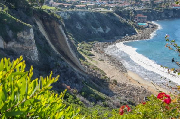
On Friday 9 December 2022 a landslide occurred on a coastal cliff at Palos Verdes Estates in California. Thanks to loyal readers Ernie Roumelis and Ken for highlighting this one – it is particularly interesting because it was caught on video from a helicopter. A Fox 11 helicopter was in the area, and succeeded in capturing the runout of the failure:-
.
.
The Daily Breeze has a couple of images of the aftermath of the landslide, including this good image of the source area:-
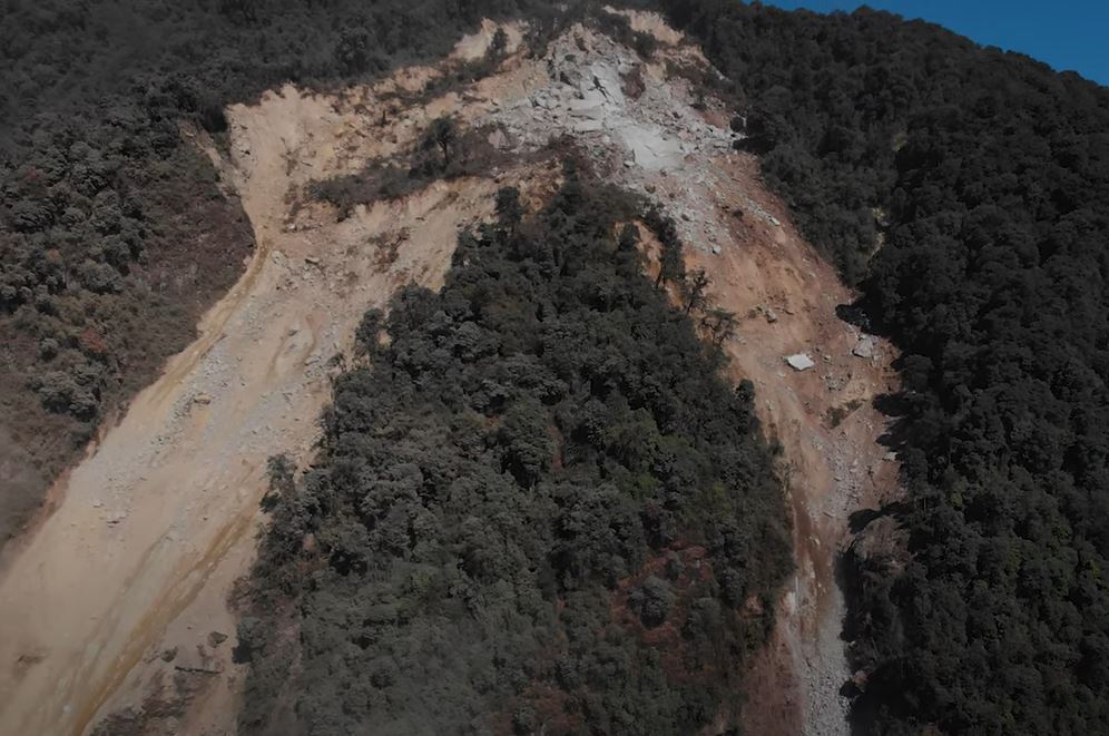
The landslide at Palos Verdes Estates. Image by Chuck Bennett via The Daily Breeze.
.
The image suggests that the failure was a structurally controlled wedge failure that turned into a dry debris avalanche. It is fortunate that the landslide occurred when the beach was largely unoccupied. Meanwhile CNN has a good image of the debris and the (fortunately unoccupied) pick-up truck that was struck by the landslide:-
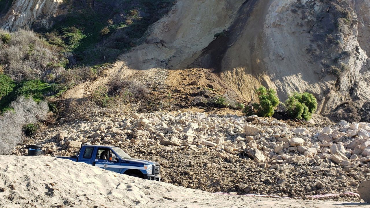
The debris from the landslide at Palos Verdes Estates. Image by Beth Jay via CNN.
.
The location of the landslide at Palos Verdes Estates is 33.804, -118.394. This is a section of coast, in common with many other locations in California, is no stranger to landslides. It is interesting that the event occurred in dry weather, ahead of the major rainstorm that affected this region over the weekend. Coastal cliff failures often seem to occur in dry weather (this is an area of active research across multiple groups at the moment). It should also be noted that artificial irrigation is common in this area, although I have no evidence of the likely cause in this case.
For those who are interested in the underlying geology, and the associated landslides, Ernie has highlighted a really interesting map produced by the California Geological Survey. Almost every cliff along this coast is likely to have experienced landslides of one form or another over time.
California remains remarkably prone to landslides of multiple types, both on the coast and inland, resulting from the combination of geology, climate, seismicity and the actions of people.
13 December 2022
The Gaguney landslide in India: evolution over time
The Gaguney landslide in India: evolution over time
Yesterday I wrote about the work that Save The Hills has been doing to highlight the plight of people of Pathing in northern India who are being affected by the Gaguney landslide. This landslide had been problematic for some time, but in November of this year the situation became dramatically worse, with a new area of instability threatening many more houses.
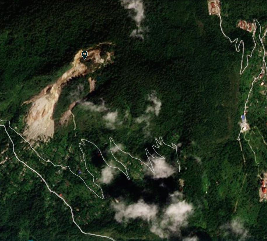
A combination of Google Earth and Planet Labs imagery provides an interesting perspective on the development of this failure. There is a good Google Earth image from 2011 – I have place the marker at the crown of the landslide at this time:-
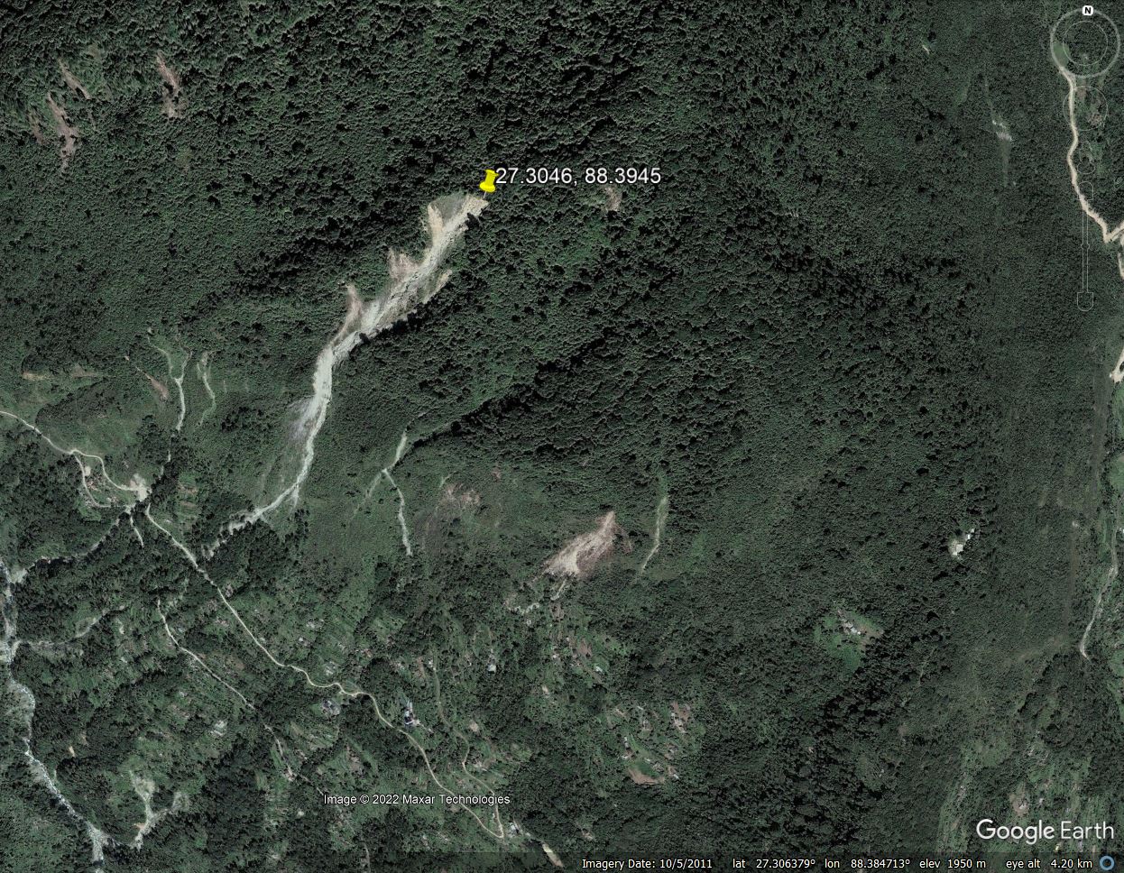
Google Earth image of the Gaguney landslide in India, collected in 2011.
.
At this point the landslide was quite well developed, but the impact on the village was quite low. The image below shows the landslide in late 2020:-
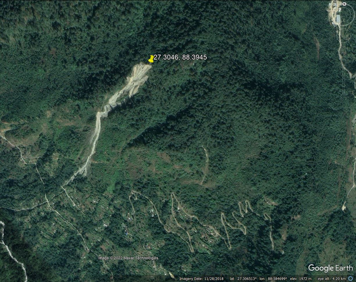
Google Earth image of the Gaguney landslide in India, collected in 2020.
.
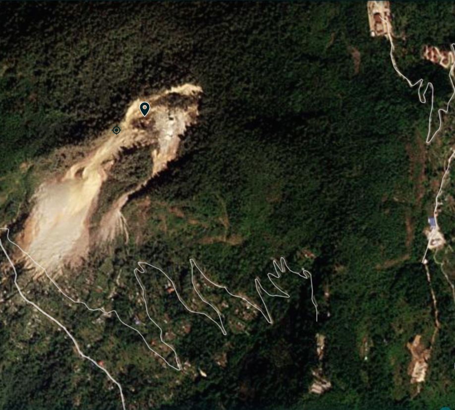
In the intervening nine years the landslide had clearly developed considerably, but again the impact downslope was quite limited. However, from this point the situation rapidly deteriorated. This is the landslide in late 2021:-
Google Earth image of the Gaguney landslide in India, collected in 2021.
.
The surface area of the landslide had expanded greatly and the debris area was large. The track into Pathing was now being affected and the village itself was being impacted.
We now switch to the lower resolution but still valuable Planet Labs PlanetScope imagery. This image is from 15 October 2022, with the marker at the same point is in the images above:-
Planet Labs image of the Gaguney landslide in India, collected on 15 October 2022. Image copyright Planet Labs, used with permission.
.
The landslide had dramatically increased in size. The headscarp had retrogressed by over 200 m, bringing a huge increase of mass into the active system. A much larger area of debris is evident downslope, and the impact on the village had also increased substantially. Perhaps most worryingly, a second area of active failure had developed to the south and east of the main landslide.
The landslide subsequently developed quickly. On 27 November 2022 the increased level of activity was starkly evident:-
Planet Labs image of the Gaguney landslide in India, collected on 27 November 2022. Image copyright Planet Labs, used with permission.
.
The main slide had further increased in size, whilst the secondary failure had also developed considerably, and there was evidence of debris impacting much more of the village. Note the substantial part of the access track that was now covered by landslide debris.
Perhaps the most worrying sign is the large volume of displaced mass that is now in the headscarp area, directly above the smaller landslide that threatens the main part of the village. This material needs to be examined in more detail – the PlanetScope imagery has a resolution that is too low for proper analysis. The threat to the village needs to be properly assessed.
.
Reference
Planet Team (2022). Planet Application Program Interface: In Space for Life on Earth. San Francisco, CA. https://www.planet.com/
12 December 2022
Save The Hills: raising awareness on impact of landslides on rural communities
Save The Hills: raising awareness on impact of landslides on rural communities
Long time readers of this blog will be aware of my admiration of a wonderful NGO, Save The Hills, which is a group of concerned citizens who seek to raise awareness of landslides in the Darjeeling-Sikkim Himalaya. I have been privileged to be in regular contact for many years with the founder, Praful Rao, and many other landslide experts have worked with the group too. They run a wonderful blog about landslides in this region. This is grass roots activism as its very finest.
As part of their efforts to raise awareness of landslides, Save The Hills has produced two short but powerful documentaries about the impact of landslides in a remote village, Pathing. The first video was made in November 2022, highlighting the way in which the large Gaguney Landslide is steadily and systematically destroying the loves of this rural community. The video combines testimony from the local people with stunning drone footage:-
.
Whilst this landslide has been active for two decades or more, in recent months it has become more active, spalling rocks almost continually. The debris has inundated land and blocked roads, as well as representing a major hazard for the local residents. The still from the video below shows the scale of the problem at Pathing:-
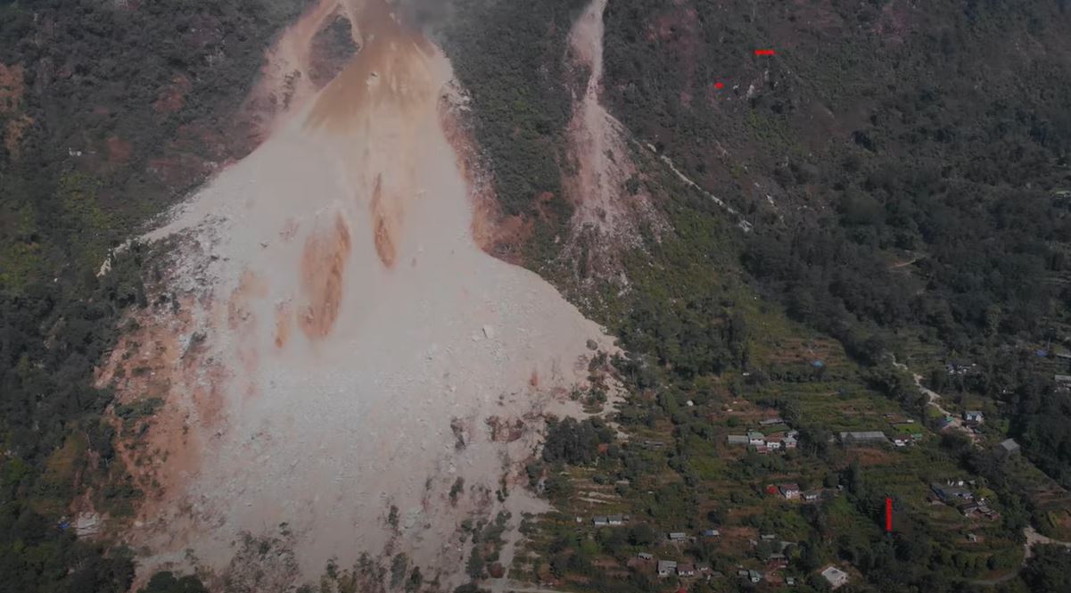
The landslide at Pathing in northern India. Still from a video posted to Youtube by Save The Hills.
.
Tragically, Save The Hills visited the site a week later to find that the situation had deteriorated desperately. The footage was collected at the end of November, when the landslide had become much more active. The government ordered evacuation of the village.
The issue appears to be that the crown of the landslide has expanded, putting many more houses at risk. The second video provides a graphic and powerful account of the scale of the problem:-
.
One key element of this second video is that it highlights the desperate plight of people being forced from their homes. Relocation is rarely simple, trading one problem for many others.
This image shows the scale of the new landslide source area, where the rock mass is clearly undergoing extensive raveling:-
The crown of the landslide at Pathing in northern India. Still from a video posted to Youtube by Save The Hills.
.
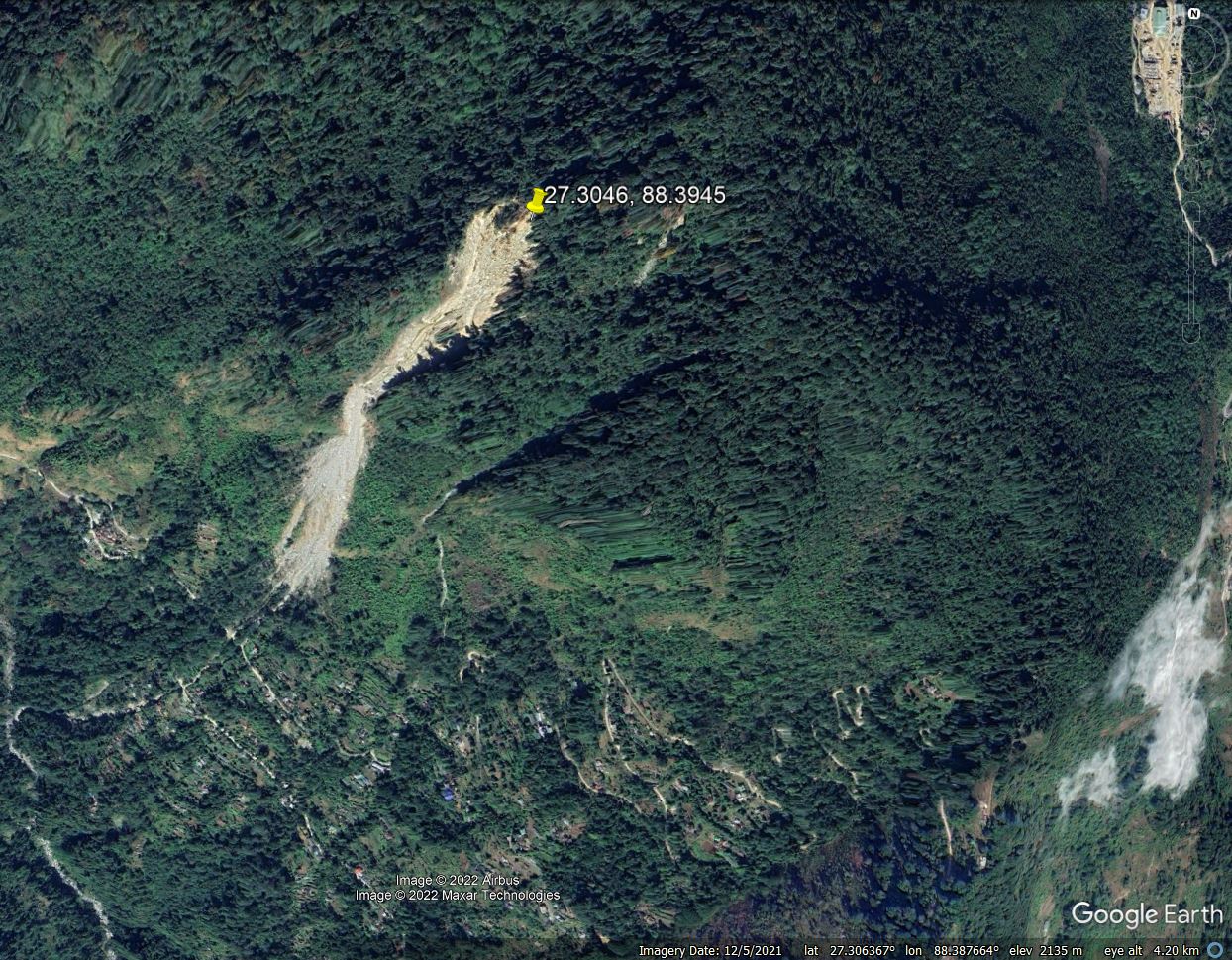
Save The Hills also has a blog post online that highlights the challenges at Pathing, illustrated by multiple photographs. Pathing is at 27.295, 88.392, and is well captured on Google Earth.
Pathing is of course not alone in this problem, which is replicated in many other locations across the Himalayas. In Nepal for example, Khabar featured another example on Saturday, this time the village of Maya in Pachaljharana Rural Municipality-8 in Kalikot district.
2 December 2022
BR-376: a deadly highway landslide in Brazil
BR-376: a deadly highway landslide in Brazil
On Monday 28 November 2022 a large landslide occurred on the BR-376 highway in western Brazil. The image below captures will the aftermath of the landslide:-
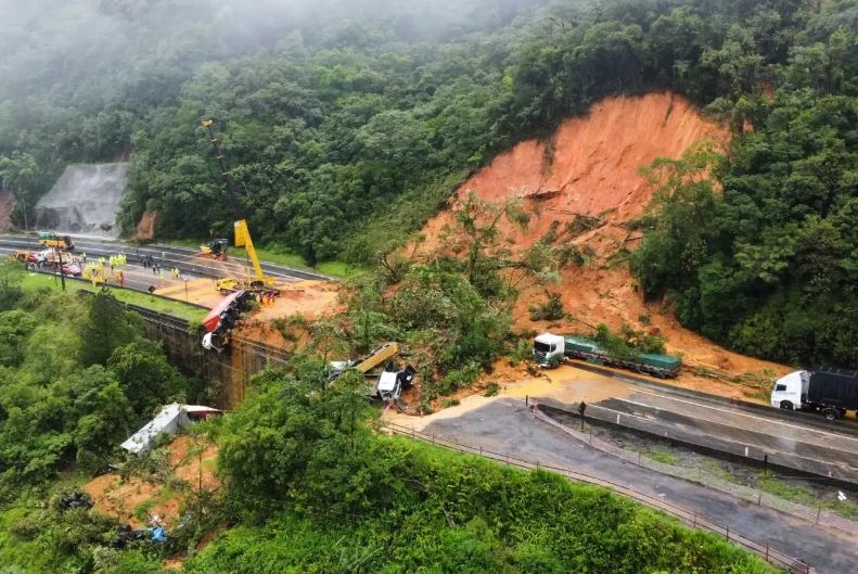
The aftermath of the 28 November 2022 landslide on the BR-376 highway in Brazil. Image by CBMSL via MetSul.
.
The image below, from the state news agency of Parana, shows the general set up of the slope that failed. This image was collected after much of the debris had been removed from the slope:-
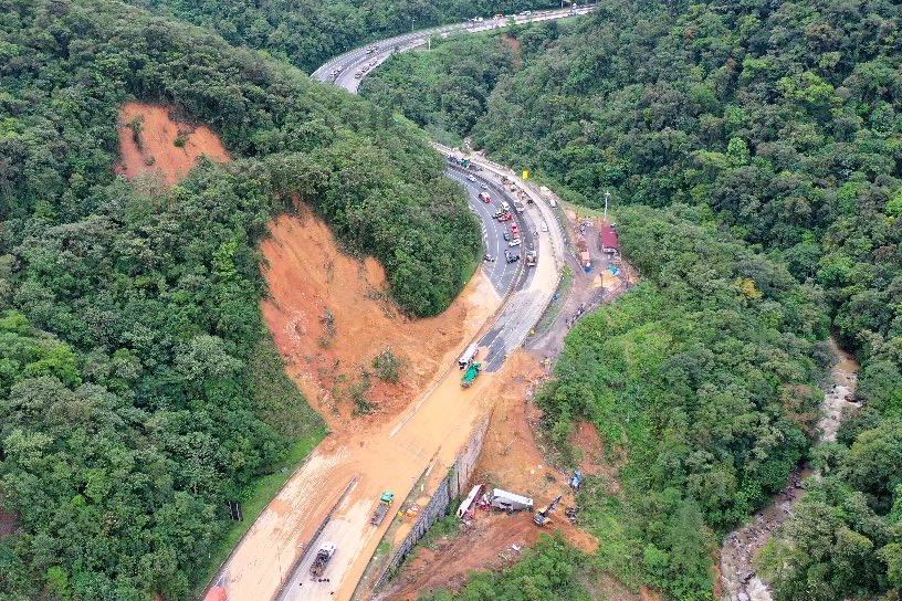
An alternative view of the aftermath of the 28 November 2022 landslide on the BR-376 highway in Brazil. Image by Albari Rosa / AEN via Parana Governo do Estando.
.
There is a good gallery of images on the MetSul website. Reports indicate that there were two failures. The first occurred at about 3:30 pm on Monday, blocking one side of the BR-376. Four hours later a second, larger, failure occurred whilst traffic was queueing to pass the spot. This is the reason why so many vehicles were caught up in the failure.
At the time of writing two fatalities had been confirmed, whilst rescue operations continue. Early fears were that there might have been as many as 30 fatalities, but thankfully this now seems unlikely.
The site was known to have stability issues, and reports indicate that work had been ongoing. The failure was triggered by heavy rainfall – MetSul reports about 200 mm on the day of the failure.
I believe that the site of the failure is -25.874, -48.937. This is the Google Street View image of the location, taken in March 2022:-
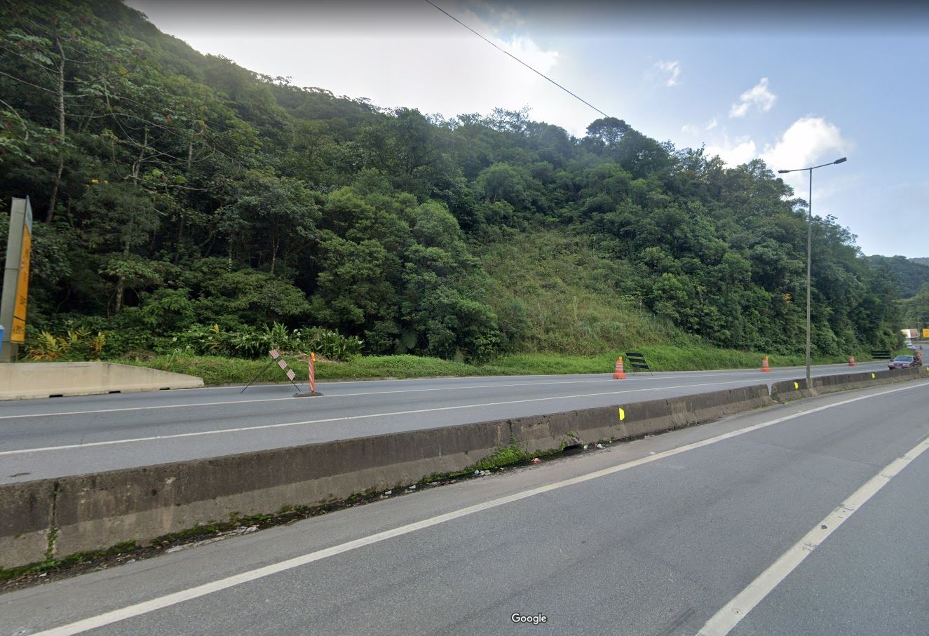
Google Street View image of the likely location of the BR-376 landslide in Brazil.
.
It is notable that works were ongoing when this image was captured, although these appear to have been focused on a site a little further along the road. The images in the aftermath of the landslide appear to show a temporary building (with a red roof), which is not present in the images from earlier this year. Is this an indication of ongoing engineering works?
The rescue and recovery operations at this site are very complex. Much of the debris and the vehicles are located off the road, below a large retaining wall. Perhaps more importantly, there is a large displaced but stalled mass on the slope that is potentially unstable. This is sufficiently large to pose a very substantial hazard to those in the debris field.
29 November 2022
Cianjur: a deadly landslide from the 21 November 2022 West Java earthquake
Cianjur: a deadly landslide from the 21 November 2022 West Java earthquake
On 21 November 2022, a Mw=5.6 earthquake struck West Java in Indonesia. The magnitude of the earthquake was comparatively low, but the event was exceptionally shallow (≈11 km), generating very high peak ground accelerations, albeit over a small but populated area. At the time of writing it is estimated that at least 323 people were killed and over 62,000 homes were damaged.
In this environment. damaging earthquakes would be expected to trigger landslides. Wikipiedia reports damage to roads and power infrastructure:
Landslides cut off roads.[28] A landslide along Puncak-Cipanas-Cianjur national road forced a traffic diversion. Toppled trees, uprooted power poles and downed power cables also occurred along roads.[29] The Ministry of Energy and Mineral Resources said two landslides occurred in Cugenang District. One measured 44 m (144 ft) and 16 m (52 ft) high while the latter measured 162 m (531 ft) and 45 m (148 ft) high.[30] A village in Cugenang with eight homes was completely buried under a landslide.[31]
The most spectacular landslide that I have seen occurred close to Cugenang, as noted above. There are images of this landslide in a Tweet by GMA News, featuring images by Antara Foto/Raisan Al Farisi via Reuters:-
https://twitter.com/gmanews/status/1595347805232836609
.
The second image is very revealing:-
Landslides close to Cugenang, triggered by the 2022 West Java earthquake. Image tweeted by GMA News, by Antara Foto/Raisan Al Farisi via Reuters.
.
The location of the main landslide is -6.795, 107.079. The image shows two other landslides, one just above the road on the far side of the main failure (also visible in the first image tweeted by GMA News), and the other on a bend in the river. The material forming the landslides is deeply weathered and the failure at the head scarp is quite deep. It is interesting that the crown of the landslide coincides with some buildings and a terrace.
It is not clear at present as to the number of other landslides that have been triggered by this earthquake, and clouds make satellite imagery hard to collect. Some reports indicate that 18 bodies were recovered from a landslide, but I am unsure as to the particular failure to which this refers.
28 November 2022
Casamicciola: drone footage of the deadly landslide at Ischia in Italy
Casamicciola: drone footage of the deadly landslide at Ischia in Italy
The deadly 27 November 2022 landslide at the town of Casamicciola Terme on the island of Ischia in Italy is now known to have killed seven people, whilst a further five remain missing. Those confirmed to have died include a three week old baby and two other children. Four people were injured. Rescue operations have continued through the night, but the prospects of anyone being recovered alive are low.
Ischia is a volcanic island with steep slopes. Landslides have occurred on manyy previous occasions, and the risk has been greatly exacerbated by unplanned urban development in locations that are simply inappropriate. Much of this development has occurred over the last three decades.
The most revealing imagery that I have seen of this landslide is a drone video that has been published on the 3B Meteo website. It shows the full length of the landslide at Casamicciola. This is the upper portion:-
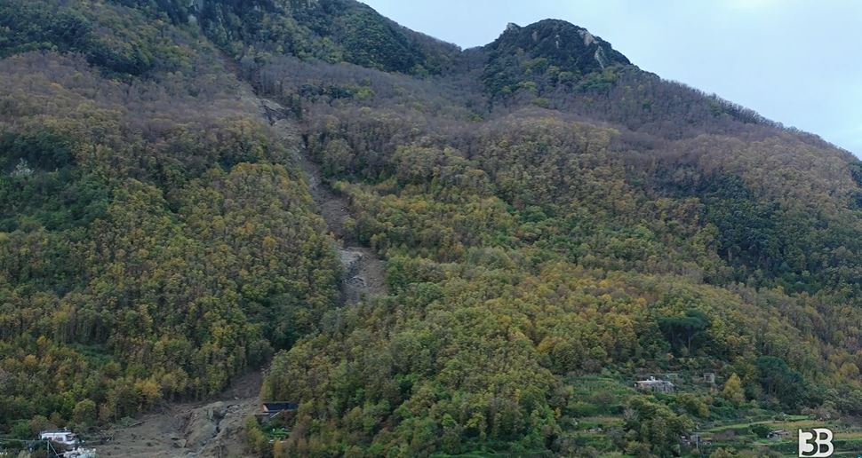
A still from a drone video showing the 27 November 2022 landslide at Casamicciola in Italy. Drone footage by 3B Meteo.
.
The path of the landslide has then run straight through the town. The still below shows the section of the upper part of the urbanbised area with the landslide track:-
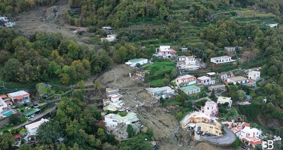
A still from a drone video showing the track of the 27 November 2022 landslide at Casamicciola in Italy. Drone footage by 3B Meteo.
.
The path of the landslide reached the sea in the lower part of the town, with vehicles and the remains of buildings being dumped into the water.
In Hong Kong this would be termed a natural terrain landslide. The drone footage appears to indicate that it initiated on the very steep upper reaches of the slope as a comparatively small failure in weathered rock. The channelised flow has then entrained large volumes of debris to generate a highly destructive flow.
In Italy, these types of events tend to generate a great deal of concern about the high levels of vulnerability to landslides. I expect that there will be many statements urging the need to deal with the risk. On previous occasions little action has actually been taken.
23 November 2022
High resolution Planet Labs images of the Kusiong landslides in the Philippines
High resolution Planet Labs images of the Kusiong landslides in the Philippines
Earlier this month I posted Planet Labs PlanetScope imagery of the Kusiong landslides in the Philippines. Rob Simmon has now acquired on my behalf a high resolution SkySat image of the area that shows the full extent of the devastation that the landslide have caused:-
Planet Labs SkySat image of the Kusiong landslides in the Philippines. Image copyright Planet Labs, used with permission, captured on 12 November 2022.
.
This is just a part of the area affected by the landslides – see my original post for the full extent. In this area multiple shallow landslides can be seen, clustered on the slopes in the upper part of the catchments:-
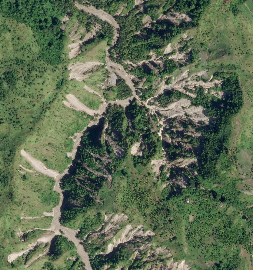
Planet Labs SkySat image of a cluster of the Kusiong landslides in the Philippines. Image copyright Planet Labs, used with permission, captured on 12 November 2022.
.
In this image alone there are over 50 landslides. Note that they are all shallow, that they originate high on the slope (which is likely to indicate failure driven by saturation caused by very intense rainfall) and they connect to the river system. Thus, as I noted previously, this is a tragic, textbook example of shallow failures transitioning to channelised debris flows.
Elsewhere in the image the impact of the debris flows on communities is clearly visible:-
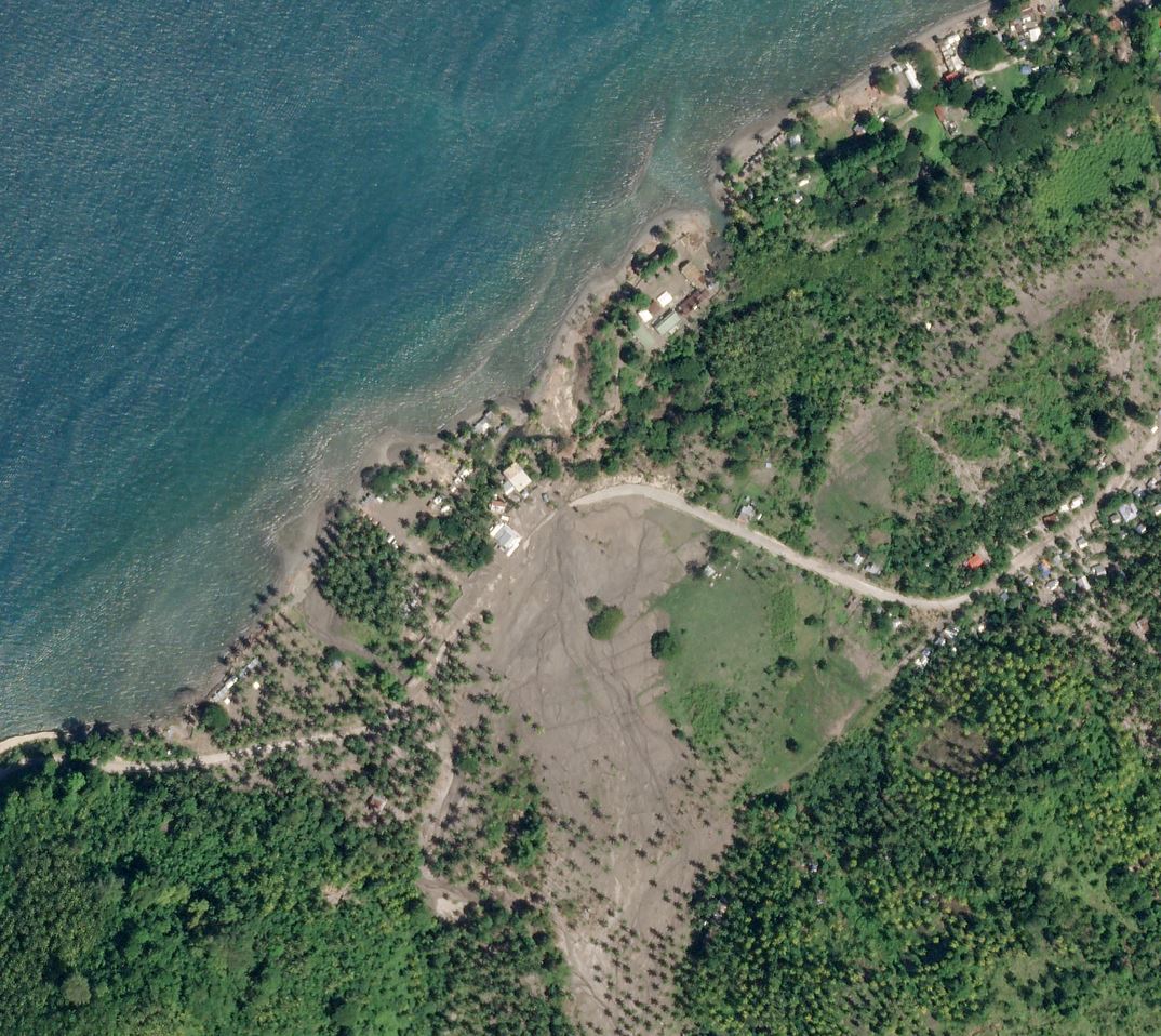
Planet Labs SkySat image of a destructive debris flow, part of the Kusiong landslides in the Philippines. Image copyright Planet Labs, used with permission, captured on 12 November 2022.
.
Note the inundation of the houses and the damage to the land at this site. It is notable that at the time of acquisition the road remained covered in debris.
The most serious damage, and many of the fatalities, occurred in a settlement on the upper slopes at 7.142, 124.088. This is the location of the photograph that I originally posted. The magnitude of the destruction at this location is laid bare in the imagery:-
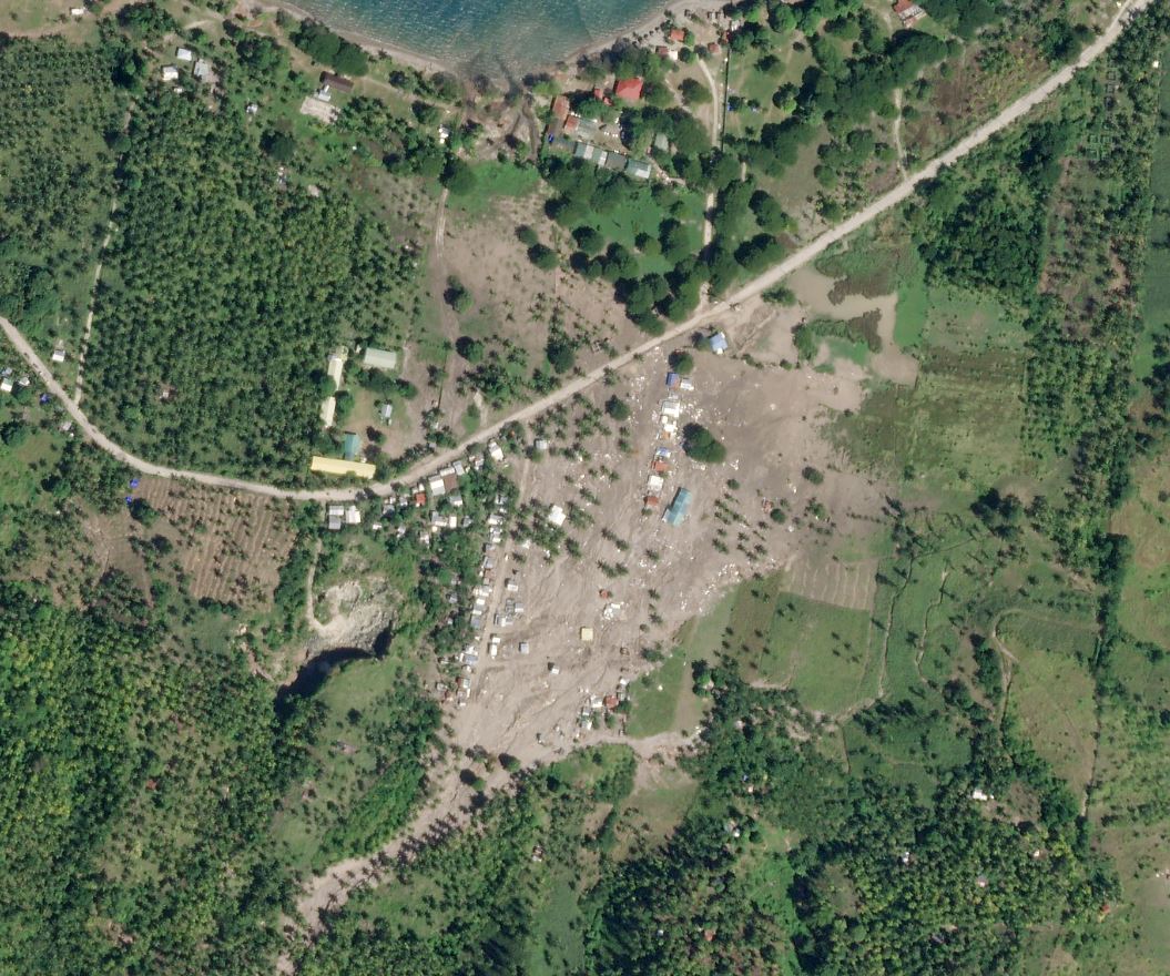
Planet Labs SkySat image of the destruction caused by the Kusiong landslides in the Philippines. Image copyright Planet Labs, used with permission, captured on 12 November 2022.
.
Many houses were destroyed in this community. Interestingly, Google Earth imagery from September 2019 shows no community at this site, and from December 2020 show just a small number of houses.
.
Reference and acknowledgements
The images are from the wonderful people at Planet Labs. Thanks in particular to Rob Simmon,
Planet Team (2022). Planet Application Program Interface: In Space for Life on Earth. San Francisco, CA. https://www.planet.com/
22 November 2022
Rubaya: at least 32 people killed in landslides in the Democratic Republic of Congo
Rubaya: at least 32 people killed in landslides in the Democratic Republic of Congo
There are various reports that landslides occurred in the towns of Rubaya and Bihambwe in the Masisi (North Kivu) part of the Democratic Republic of Congo on 18 November 2022, killing 32 people. Of these 26 people were killed at Rubaya, whilst six were killed at Bihambwe. It is not clear as to whether this was a single landslide that affected both sites, or two separate landslides. Radio Kapi has an image of a large landslide, but again it is not clear as to whether this is the event that cost so may lives at Rubaya:-
A landslide at a mining site near to Rubaya in the Democratic Republic of Congo. It is unclear as to whether this is the event that cost 26 lives. Image from Radio Kapi / Denise Lukesso
.
The landslides were triggered by heavy rainfall, but appear to have been associated with illegal and/or unregulated mining activities. Floodlist reports extensive flooding and landslides in the Democratic Republic of Congo since early November, including four deaths in Bunyakiri in the territory of Kalehe in South Kivu.
A freelance journalist, Baraka Munyampfura Héritier, has tweeted a short video of a landslide destroying houses in the area. The interesting part happens in the first 15 seconds:-
#RDC Au_moins vingt personnes sont mortes samedi et vendredi dans des éboulements et inondations causés par des fortes pluies dans le site minier de #Rubaya en territoire de #Masisi au #Nord_Kivu. Parmi les victimes des creuseurs et villageois selon l' #AFP. pic.twitter.com/r1pct2vuiA
— Baraka MUNYAMPFURA Héritier (@HeritierBarak) November 20, 2022
.
There is little information at present as to the circumstances of this event.
The mines at Rubaya are described in Wikipedia. They appear to be focused on the extraction of coltan (tantalite), from which niobium and tantalum are extracted. These mines are in the vicinity of -1.558, 28.884. The Google Earth imagery of the area does not present a pretty picture:-
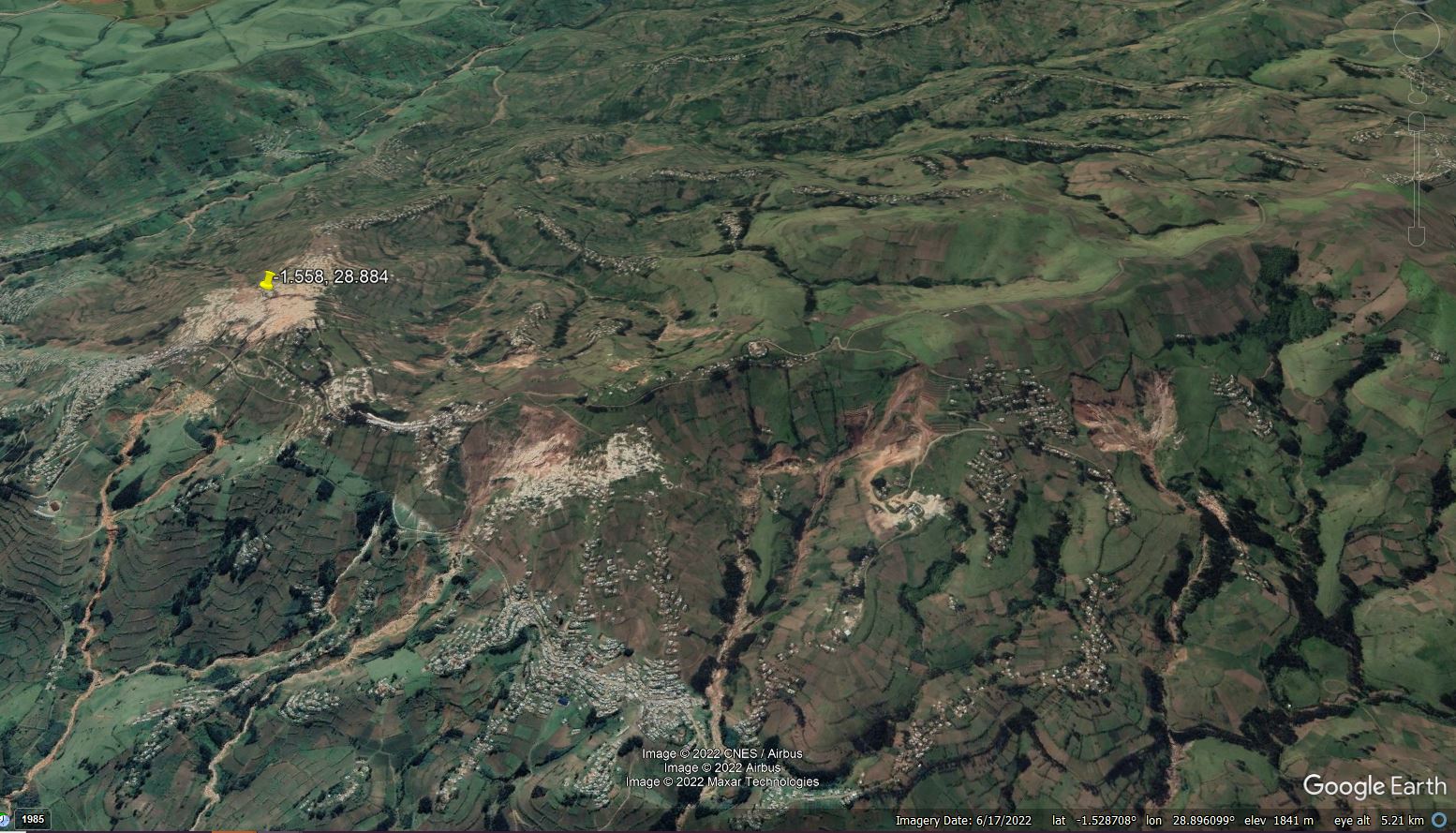
Google Earth imagery of the Coltan mines in the area of Rubaya in the Democratic Republic of Congo.
.
There is a lack of detail about landslides of this type in parts of Africa. It seems likely that events are substantially under-reported.
20 November 2022
Satellite imagery of the El Molino landslide in Norte de Santander, Colombia
Satellite imagery of the El Molino landslide in Norte de Santander, Colombia
The Planet Labs PlanetScope satellite instruments have captured imagery of the 10 November 2022 El Molino landslide in Colombia. This is a cloudy area at this time of year, so obtaining images can be a challenge. This is the site as of 11 November, with the track of the landslide clearly visible:-
The 10 November 2022 El Molino landslide. Planet Labs PlanetScope image, copyright Planet Labs, used with permission. Image captured 11 November 2022.
For comparison, this is an image of the same location on 3 October 2022:-
The site of the 10 November 2022 El Molino landslide. Planet Labs PlanetScope image, copyright Planet Labs, used with permission. Image captured 3 October 2022.
.
To allow comparison I have created a slider, which should allow you to see the site before and after the landslide:-
.
There are two really interesting aspects of this site. First, the landslide has picked out rather well the deforested area in the upper catchment. I am unsure as to whether this indicates that the loss of vegetation may have been a factor or that there was a strong topographic control on both the farmland and the landslide. I would tend towards the latter, but would be interested in views.
Second, it appears that there was an earlier, smaller but quite long runout landslide at this site, as shown in the October satellite image. I have enlarged this below:-
The earlier landslide at the site of the 10 November 2022 El Molino landslide. Planet Labs PlanetScope image, copyright Planet Labs, used with permission. Image captured 3 October 2022.
.
The resolution of the imagery is not good enough to understand this slide properly. It may well have played a role in the development of the main failure.
Meanwhile, as of three days ago the five victims of the landslide had not been recovered, and there is concern about the damming of the river as well as about the potential for a further landslide. A small lake has developed.
The landslide destroyed 670 hectares of land, whilst 130 people have been rendered homeless.
.
Reference and acknowledgements
The images are from the wonderful people at Planet Labs.
Planet Team (2022). Planet Application Program Interface: In Space for Life on Earth. San Francisco, CA. https://www.planet.com/
16 November 2022
Mizoram: a deadly quarry rockslide caught on video
Mizoram: a deadly quarry rockslide caught on video
On 14 November 2022 a significant rockslide occurred at Maudarh in Hnahthial district, in Mizoram, India. Tragically, 12 workers were caught up in the landslide, alongside five excavators, a stone crusher and a drilling machine. To date 11 bodies have been recovered; it is highly unlikely that the other victim will be recovered alive.
The event was captured on video – I was made aware of this in a tweet by SANDRP. The video is on Youtube:-
.
India Today has a photograph of the aftermath of the landslide:-
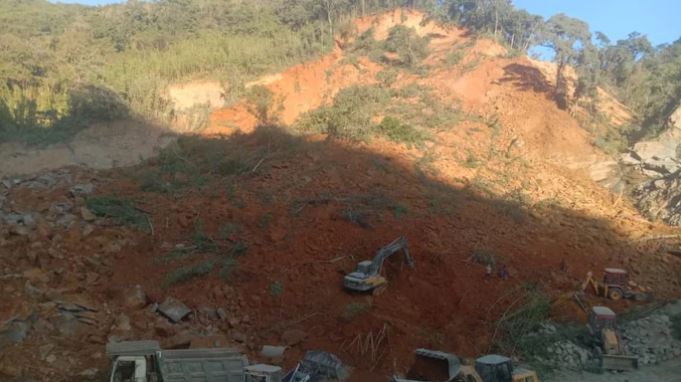
The aftermath of the 14 November 2022 landslide at Maudarh in Mizoram. Image from India Today.
.
The image below shows one of the first frames from the video of the landslide:-
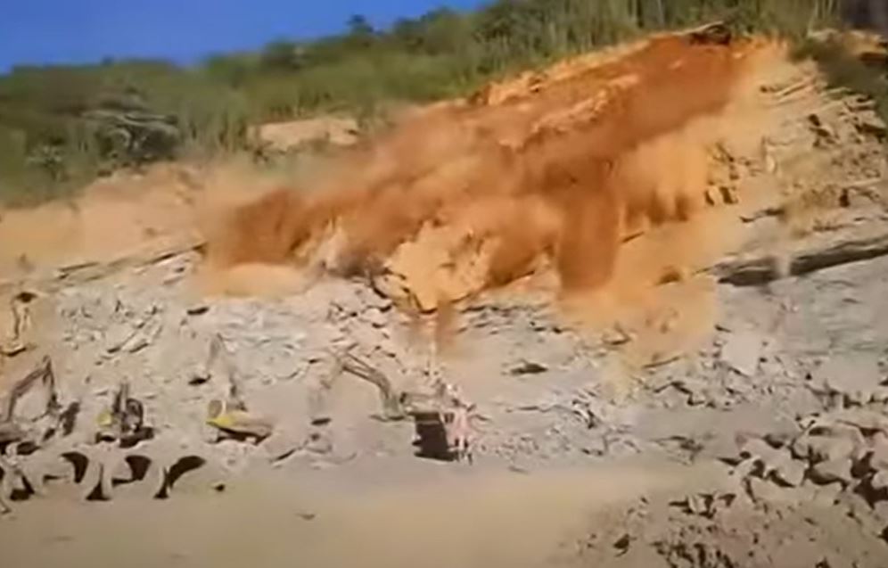
The early phases of the 14 November 2022 landslide at Maudarh in Mizoram. Still from a video uploaded to Youtube.
.
The landslide appears to originate in residual soil high up on the slope above the quarry. As both images above show , the landslide debris involves mostly weathered rock, although the video itself shows some failure of the rock that was being quarried too, especially on the right hand side. So, a provisional interpretation might be that the quarry operations had not removed enough of the weathered material high up on the slope, which then failed due to the loss of toe support. The debris then triggered some failure of the rock being quarried in the lower part of the slope.
It is interesting that the weather was sunny and dry at the time of the failure.
In general investigations of landslides like this conclude that they were avoidable accidents. The quarry at Maudarh in Mizoram, which is being used to extract stone for the construction of a new national highway in the area, appears to be located at 22.915, 92.893. A quarry at that location is visible on satellite imagery.
 Dave Petley is the Vice-Chancellor of the University of Hull in the United Kingdom. His blog provides commentary and analysis of landslide events occurring worldwide, including the landslides themselves, latest research, and conferences and meetings.
Recent Comments