
29 July 2016
Landslides in Nepal from the 2016 monsoon
Landslides in Nepal from the 2016 monsoon to date
Nepal has been very seriously affected by the 2016 monsoon, with prolonged heavy rainfall causing landslides across a large swathe of the country. The consequences have been severe – I have been trying to collate information on losses based upon newspaper reports. To date I have recorded 73 landslide related deaths in 19 separate landslides this week. Of course many thousands more have been severely affected as roads and buildings have been damaged and destroyed. Ekantipur has this powerful image of one of the fatal landslides – this one killed a 12 year old girl in Parbat:
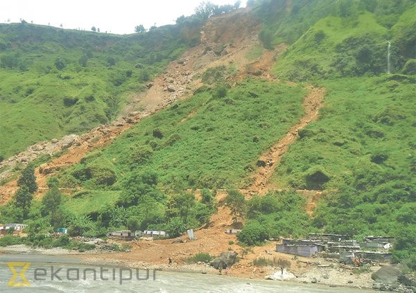
A landslide triggered by the 2016 monsoon in Nepal, via eKantipur
.
This is a complex landslide that in the lower reaches transitioned into a debris flow. Note the location of the structures in relation to the path of the flow.
As usual a key issue has been the role of poorly engineered roads in triggering landslides, and in many places there are reports that roads have played a key role in the failures. So, for example, in Pholpi VDC in Pyuthan, which at the moment seems to have suffered the highest number of losses (27 deaths in my dataset), MyRepublica has this quote:
“We were actually not at any risk. The newly-constructed rural road is the reason for these landslides,” said Shivaraj Subedi, a local. “The soil was greatly loosened up after the use of an excavator to construct the road. Loose soil coupled with heavy rainfall led to this big disaster.”
Similarly in Bajura poor quality road construction has been identified as a key issue:
Haphazard use of heavy equipment for road construction in Bajura has affected nearby human settlements negatively…. “Although road construction is a good thing, the work is being done without properly considering the geographical sensitivity of the area, and many human settlements are in peril,” said Tula Thapa, a local teacher. At the Phalasain-Kuldevmandau road construction site, locals have complained of increased threat of landslides triggered by the projects.
This is not new of course, and I have been banging this drum for years. For example, back in 2013 I highlighted an example of landslides being triggered by poor quality road construction in Gorkha District. Needless to say the problems have continued unabated.
Finally, in Sindhupalchok district, which was severely affected by landslides in the 2015 earthquakes, landslides are also causing serious difficulties. The Himalayan Times reports that:
Most of the rural roads in Sindhupalchok district have been obstructed due to landslides triggered by incessant rainfall.
There is evidence that humans have played a role here too. When the Araniko Highway to Tibet was blocked by landslides last week, a new access road started to be opened using bulldozers. Four days ago the Kathmandu Post reported that:
Heavy rains in Sindhupalchok damaged the construction works for the 26-kilometre alternative route to connect Barhabise with Tatopani on Thursday night, after flash floods two weeks ago swept away the parts of Araniko Highway in the district. Divisional Road Office chief, Ashok Tiwari, said 50 percent of the construction they had accomplished, a 13 km track from Barhabise till Jambu, in the last few days was destroyed by landslides. Khorang, Jhyalebhir and Dakalang are seeing the worst landslides.
This was so tragically predictable. When this was announced I wrote the following in an email to a friend in relation to the initial reports of them building this track:
Pragmatic maybe, but this is an area mantled with many quasi-stable very large landslides. These hastily constructed roads trigger instability. This is likely to compound the problems in the short term.
It really did not need a landslide specialist to know this. If Nepal wants to reduce its losses to landslides it must get a grip on this poor quality of road construction.
28 July 2016
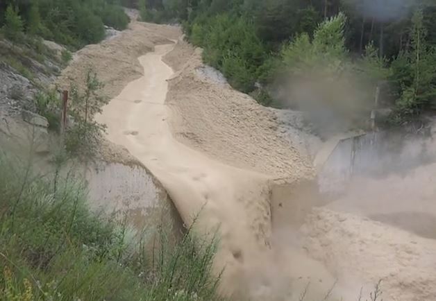
Illgraben debris flow video
Illgraben debris flow video
The Illgraben is a very active alpine catchment located near to the near the village of Susten (Leuk), in Canton Valais, Switzerland. This catchment is particularly interesting because it generates a large number of debris flows, some of which are very large. Since 2000 WSL has been using Illgraben as a monitoring site for debris flows. They have installed instrumentation in the catchment and in the debris flow channel. Not surprisingly, cameras are a part of the set-up, meaning that several large debris flows have been recorded. WSL has also built a warning system for the catchment in order to protect the local population.
Pierre Zufferey has recently posted a video of one such debris flow on Youtube. This event occurred on 22nd July 2016 according to the Youtube page. It is truly spectacular:
.
In one film this video illustrates many of the characteristic elements of a debris flow. So, for example, the front of the flow consists of large number of (in this case) huge boulders tumbling chaotically:
The boulder-dominated front of the Illgraben debris flow, via Youtube
.
Behind the front the debris flow consists of a very debris rich but much more fluid slurry:
The main, more fluid portion of the Illgraben debris flow, via Youtube
.
As the discharge starts to decline the debris flow creates a narrower channel, leaving deposits (levees) on both flanks:
Declining flow in the Illgraben debris flow, via Youtube
.
By the end of the video the flow has migrated into the centre of the channel, leaving new debris flow deposits on either bank, and creating a morphology very similar to that before the flow arrived (see the first picture above):
The final phase of the Illgraben debris flow, via Youtube
.
WSL will have captured this debris flow in their instrumentation. I would imagine that it will be a fascinating dataset.
27 July 2016
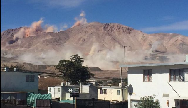
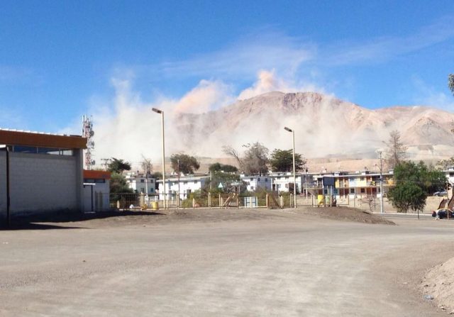
Landslides from the M=6.1 earthquake in the Atacama Desert on 25th July
Landslides from the M=6.1 earthquake in the Atacama Desert on 25th July
On Monday a M=6.1 earthquake occurred in the Atacama Desert, 53 km to the north of the town of Diego de Almagro in Chile. This was not a very large earthquake, and it occurred at 71.5 km depth according to the USGS, meaning that the impact was low. It is likely to have generated comparatively low intensity shaking over a large area.
On Twitter, a series of images were posted of the impact of the earthquake in El Salvador, a mining town located in the Atacama desert about 100 km from the epicentre of the earthquake. These show large plumes of dust being generated in the mountains around the town:
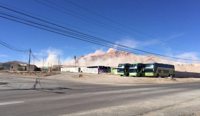
Dust clouds being generated in the hills in the Atacama Desert after the M=6.1 earthquake in Chile on Monday, via Twitter
.
Dust clouds being generated in the hills in the Atacama Desert after the M=6.1 earthquake in Chile on Monday, via Twitter
.
Dust clouds being generated by landslides in the hills of the Atacama Desert after the M=6.1 earthquake in Chile on Monday, via Twitter
.
Clearly there was significant landslide activity in this earthquake, although it is likely that the slides will mostly have been small and localised. We know little about landslide activity during earthquakes in very arid conditions, so this is a technically interesting event. The images suggest that the effects might have been similar to those from the 2010 Sierra Cucapah earthquake in Baja California, Mexico, which was captured on a youtube video that I posted at the time. Working with colleagues at Durham, most notably John Barlow (who is now at the University of Sussex), we used satellite imagery to investigate at these landslides. This work was published about 18 months ago (Barlow et al. 2014), and I posted a commentary about the paper at the time. In that case we found that large numbers of comparatively small landslides were able to generate a large amount of dust.
Reference
Barlow, J., Barisin, I., Rosser, N., Petley, D., Densmore, A. and Wright, T. 2014. Seismically-induced mass movements and volumetric fluxes resulting from the 2010 Mw = 7.2 earthquake in the Sierra Cucapah, Mexico, Geomorphology, 230, 138-145, http://dx.doi.org/10.1016/j.geomorph.2014.11.012.
25 July 2016
Gangotri and China: three fascinating new landslide videos
Gangotri – a very nice rockslide video from India
As Asia reels under extraordinary rainfall under strong monsoon conditions, three new, interesting landslide videos have been posted on Youtube. The first shows a rather elegant rockslide on the highway to Gangotri in Uttarakhand in northern India:
.
This is a classic of its type – a translational rockslide on a joint system dipping out of the slope. It is likely that trimming of the slope to create the road has removed the natural buttress at the toe of the slide, allowing slip to occur on the existing weakness when pore pressures are high.
Gangotri rockslide via Youtube
Note also the very large amounts of dust generated by the landslide.
A spectacular landslide from China
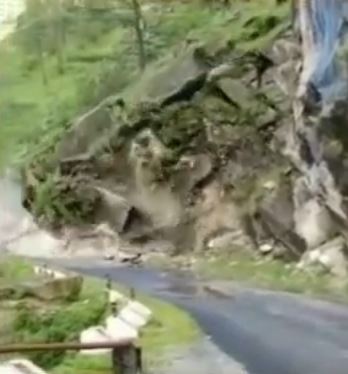
This video first appeared on Liveleak, and has now migrated to Youtube as well. The landslide is from a highway in China, but no other details are available:-
.
The magnitude of the landslide is very large. Note that both section of the landslide occurred on slopes that have been cut to create the road bench, and then reinforced to provide stability:-

Massive roadside landslide in China, via Youtube
.
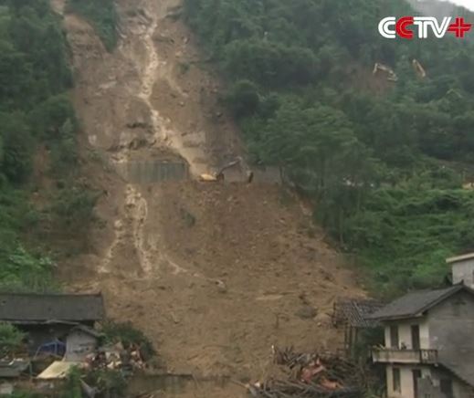
The aftermath of a landslide in China
And finally, CCTV has now posted a very nice video of the aftermath of the widely circulated video of a landslide destroying houses in a rural village in Hunan Province:
.
This is the original video:
.
In this case there is a railway line running across the slope – the failure appears to have occurred at the tunnel portal:
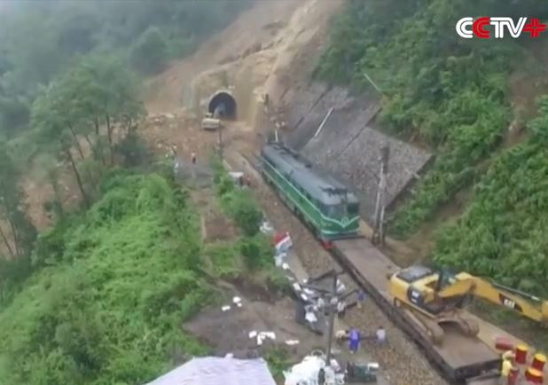
Landslide in China via CCTV and Youtube
.
It’s hard to know whether earthworks for the line played a role in the landslide, but it seems like a prime candidate:
Footage of the aftermath of a landslide in China, via CCTV and Youtube
.
These three landslides all rather nicely illustrate the ways on which poor slope management is exacerbating landslide problems in upland areas of Asia.
22 July 2016
The University of Sheffield

The University of Sheffield
It is with great excitement that I can announce this morning that, as from 1st November 2016, I will be moving to take up the position of Pro-Vice-Chancellor (Research and Enterprise) at the University of Sheffield. The University has formally put out a press release with this news this morning. A Pro-Vice-Chancellor is the equivalent of a Vice-President in the US system. I will help to provide strategic leadership in research across the university, and will lead on all innovation (knowledge transfer, enterprise, consultancy, business generation, etc) as well. It is a very exciting step for me.
Sheffield is a very strong, research-led Russell Group (the UK equivalent of the Ivy League) university. It’s in the World top 100 institutions, with over 27,000 students and a research income of over £140 million. It has a fabulous reputation for the quality of the student experience – it came third out of 117 institutions in the 2016 Times Higher Education Student Experience Survey for example.
Of course, this means that with great sadness I will leave the University of East Anglia on 31st October. I will do so with real sorrow – I’ve loved my time at UEA. It’s a great university, one that also focuses on the student experience (UEA came 7th in the same survey), and I have had the honour and privilege to work with some amazing people. UEA is a university that has extraordinary strength, amazing staff and an astonishing can-do attitude. Its location in the East of England means that it will play a fundamental role in the development of a gorgeous part of the UK. Until I moved to Norwich I had not appreciated what an amazing city it is. Being here has been absolutely instrumental to my career, and I have loved every minute of it. The university has a tremendous future ahead of it, and I shall watch with great interest as the university develops.
But I see amazing opportunities in Sheffield, and I cannot wait to play a part in the development of that wonderful university. It is an institution that is firmly rooted in its city and region, which will play a massive role in helping Britain to find a new path in the wake of the Brexit result. I feel deeply honoured to have been asked to join the University of Sheffield, and am hugely looking forward to working with colleagues and students across the institution.

The new Diamond Building at the University of Sheffield, via De Zeen
19 July 2016
The Aranayake landslide disaster in Sri Lanka – a JICA report
The Aranayake landslide disaster in Sri Lanka
JICA has now posted a report online (NB it’s a PDF) providing the initial results of an investigation of the May 2016 Aranayake landslide disaster in Sri Lanka, which killed 127 people.
This is a complex landslide – the image below from the report provides the best overview of the whole of the landslide, from the small failure at the crown to the debris flow at the toe:
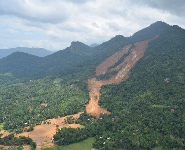
The Aranayake landslide in Sri Lanka, from the JICA report
.
This this image shows the complex translational component of the landslide. The report points out the unusual width of the landslide, which was not evident in most of the images at the time:
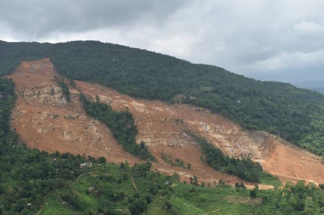
The main part of the Aranayake landslide in Sri Lanka, via JICA
.
I think there are two really revealing aspects to this report. First, it provides a detailed aerial image of the very crown of the landslide:
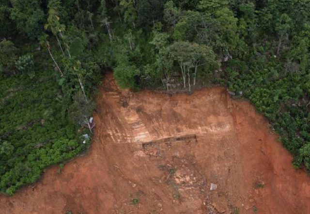
The crown of the Aranayake landslide, via JICA
.
Whilst it might on first inspection be thought that this small failure induced the overall collapse, this strange feature in the very crown of the landslide may well be a secondary failure, judging by the debris on the slope below. However, I still believe that the landslide was initiated by a failure in the crown area (but possibly over a larger area than shown above). It is interesting that the primary forest appears to have been removed in the areas on the flanks of the landslide shown in this image. This might provide an explanation for why this first failure developed.
Second, the report provides details of the settlements that were destroyed by the landslide:
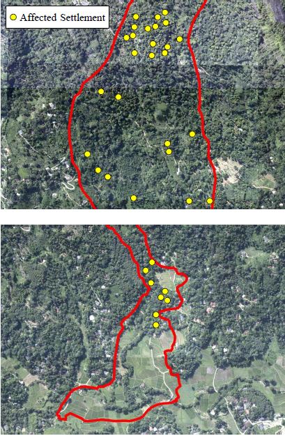
Settlement locations on the Aranayake landslide, via JICA
.
An interesting question is whether this specific landslide could have been anticipated. This is the outline of the landslide superimposed onto a slope angle map:
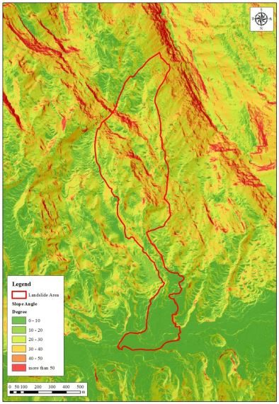
The outline of the Aranayake landslide superimposed onto a slope map, via JICA
.
It is probably fair to say that the specifics of this landslide could not have been identified in advance. This type of very complex, cascading failure is always going to be exceptionally hard to anticipate. However, that this type of landslide will occur in general in exceptionally heavy rainfall in the mountains of Sri Lanka can be anticipated. The houses located in the lower channel of the landslide, which is clearly identifiable in the image above, were probably at an unacceptably high level of risk from the perspective of landslide hazards.
Acknowledgement
Thanks to Kenichi Handa of JICA for highlighting this report to me, and for the most interesting discussion.
18 July 2016
Monsoon 2016: Nepal reels under the effects of multiple landslides
Monsoon 2016
In the aftermath of the May 2015 earthquake we have been worried that the first really intensive period of rainfall would lead to significant landslide problems in Nepal. Unfortunately, as Monsoon 2016 really gets into gear this scenario is playing out. Northern areas of Nepal are being affected by large amounts of rainfall. The landslides are dominating the news in Nepal – for example this is the front page of the Himalayan Times this morning:-
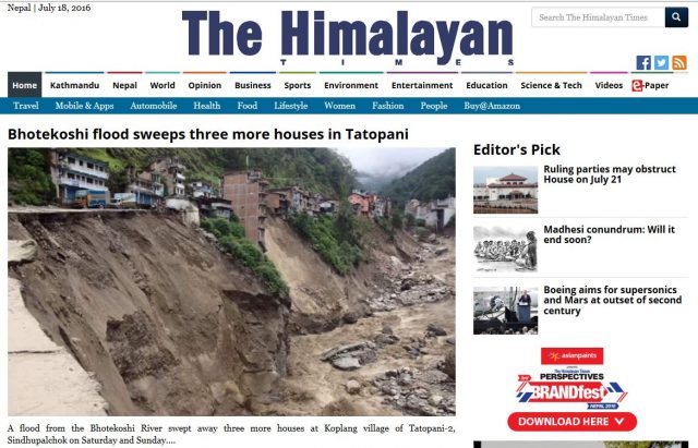
Monsoon 2016: The front page of the Himalayan Times this morning
.
This is reporting the ongoing problems in the catchment of the Bhote Kosi following the landslide dam break flood of last week. Whilst the damage and disruption to this area is undoubtedly extreme, I am deeply concerned by this report of plans to bulldoze a new, 26 km long track to create an alternative alignment to Tatopani:-
The Divisional Road Office (DRO) has started work to open a 26-kilometre alternative track to connect Barhabise with Tatopani in Sindhupalchok district after a flashflood last week destroyed much of the road. The under-construction Middle Bhotekoshi Hydropower Project is providing financial assistance to open the road from Chaku to Khohra. The DRO has started construction in the remaining section of the road up to Tatopani. The project has already opened the alternative way from Chaku. The project is using three excavators at the site. Chief of the 102 megawatt project Sunil Kumar Lama said landslides continue to occur in Khohra and other areas. Senior civil engineer Sanjay Sapkota said construction works will be completed in a week though the river is still eroding sections of the Araniko Highway.
These low tech roads are both environmentally catastrophic and exceptionally hazard prone. This is an area that basically consists of quasi-stable landslide deposits, and even the existing road is very landslide-prone. In the medium term the opening of a new road is likely to make the problem far worse.
Meanwhile, other catchments are also showing distinct problems. The Mahakali River is reported to be very high and is actively eroding its banks:-
A flood in Mahakali River has started eroding the embankment at Bhimdatta Municipality-11 in Kanchan-pur district. On Sunday, the river eroded the levee that was constructed near Bhujela last year. Technicians from the People’s Embankment Programme (PEP), Kanchanpur said the flood caused by incessant rains in the hilly areas of the far-western region started eroding the banks on Saturday night. PEP chief Bhilananda Yadav said the embankment would be destroyed if the dike is swept away. “We are going to protect the embankment with gabions,” he said. Shankar Chhetri of Bhujela said they have been alerted against the river flooding their settlement.
Perhaps most worrying is the situation on the Tamor River, which has been partially blocked by a landslide. News yesterday was that the water level is rising:
Water level in landslide-dammed lake in Tamor River in Sawadin, Taplejung, has increased, leaving the downstream settlement at risk. A fresh rockfall blocked water flow in the river. Pawan Shrestha, a resident of nearby Mitlung Bazaar, told the Post over the phone that the water level in the debris-dammed lake gradually increased on Saturday.
The Kathmandu Post published an image last week of the landslide and lake from the upstream side:
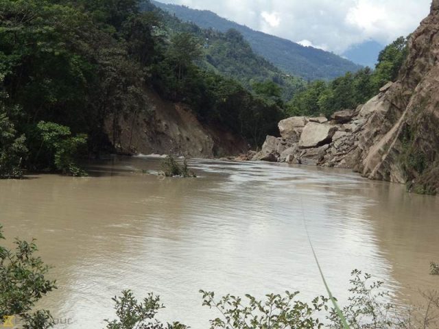
Monsoon 2016: Kathmandu Post image of the landslide dam on the Tamor River
.
17 July 2016
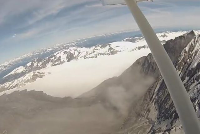
Glacier Bay Landslide in Alaska: a satellite image and new videos
Glacier Bay Landslide in Alaska
Slowly more information is emerging about the very large Glacier Bay landslide in Alaska, upon which I have previously blogged. Perhaps most importantly. the landslide has now been imaged by the ESA Sentinel-2 satellite. The image was tweeted by @RemotePixel on 14th July, with the image having been collected on 11th July 2016:
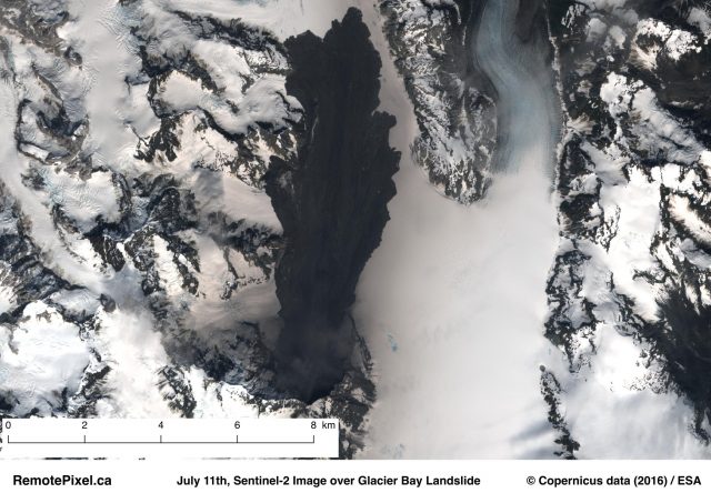
The Glacier Bay landslide in Alaska, as imaged by the Sentinel-2 satellite. Hat-tip to @RemotePixel
.
It is interesting to see how little this landslide spread laterally, especially on the right side of the track (the left side is clearly constrained by the topography).
In addition, there are now a couple of videos on Youtube showing aerial images of the landslide. This one, by Jillian Rodgers of KHNS Radio, is marred by irritating music, but gives a pretty good impression of the landslide:
.
It includes two really good shots of the landslide source / scar area:
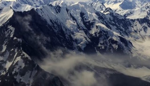
Still from a Youtube video of the Glacier Bay landslide in Alaska
And:
Still from a Youtube video of the Glacier Bay landslide in Alaska
.
Paul Swanstrom, the pilot who found the landslide in the first place, has also posted a short video of the crown of the landslide:
.
This serves to rather beautifully show the immense fall height of this landslide. Both videos also demonstrate clearly that there is still a huge amount of rockfall activity occurring on the landslide scar, and the first video suggests that a new scree deposit is accumulating on the landslide body.
16 July 2016
Ya’an City, Sichuan: a video of a very near miss
Ya’an City, Sichuan: a video of a very near miss
CCTV has published on Youtube a pretty dramatic video of a very near miss for a landslide in Ya’an City in Sichuan Province, China. The accompanying text says:
Last Friday evening, when a bus with 42 passengers was driving at 318 National Road in Ya’an city, southwest China’s Sichuan Province, the 59-year-old driver noticed rocks sliding down from the mountain. He immediately pressed his brakes and reversed about 10 meters. The mountain collapsed in a minute and buried the place. But thankfully, the driver was quick enough to avert any untowardly incident.
The video is quite exciting. The consequences should the bus have been in the wrong place are clear:
.
Some images of the landslide appear to show a car caught up in the debris:
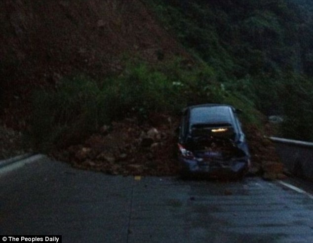
Ya’an City landslide via The People’s Daily
.
Fortunately this looks to have been survivable for the occupants. China Daily has more information about the landslide:
Huang Guiquan has been a driver all his life. He attributed his swift thinking to his long driving experience and familiarity with the road. “It is important for a driver to be observant of the environment all around rather than just staring at the road ahead,” he said. It was raining. He decided to stop the bus when he saw some stones falling down the mountain slope. “Trees swayed on the mountainside, but there was no wind at that moment. I thought that it must be the mountain itself that was shaking so I backed up the bus,” he said. The road is high on the Qinghai-Tibet Plateau and prone to snow in winter and landslides in summer. Huang is familiar with the road conditions on all his regular routes. “I am particularly careful when driving through the sections with sharp turns, steep slopes or frequent landslides,” he said. “It is always better to stop than rush when in danger.”
14 July 2016
Bhote Kosi, Nepal: serious damage after the failure of a landslide dam in Tibet
Bhote Kosi, Nepal
The Bhote Kosi valley, to the north of Kathmandu, was one of the areas most seriously affected by the 2015 earthquake in Nepal. Much of the damage was caused by landslides, which occurred on many slopes. Fortunately the comparatively benign 2015 monsoon season did not exacerbate the problems as much as had been feared, but the consequences of the next period of intense rainfall always looked grim. This is a section of the valley for example:
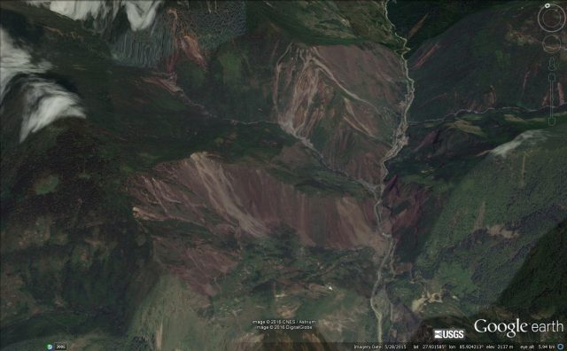
Google Earth imagery of the Bhote Kosi valley, showing the multiple earthquake induced landslide
.
Apart from the local population, this valley is important as it is the alignment of the Arniko Highway, which is one of only two links between Nepal and Tibet, and thus China.
The 2016 monsoon has arrived with a bang, bringing very heavy rainfall. Last week a very large flood swept down the Bhote Kosi, with devastating effects. This was almost certainly a landslide dam break flood from a blockage in the river in Tibet, and it must have been large. However, as yet the location is unclear. The Nepal media has various reports of the impact of the flood – the Himalayan Times for example reported that:
The deadly earthquake of last year had devastated Liping and Tatopani Bazaar of Sindhupalchowk. Before these places could recover, flood in the Bhote Koshi River has left these towns so battered that reconstruction seems impossible. Of the 200 houses in Tatopani and Liping bazaars, the Bhote Koshi flood has washed away 67 houses till today noon, police said.
The best image of the aftermath of the flood is on the Himalayan Times website:
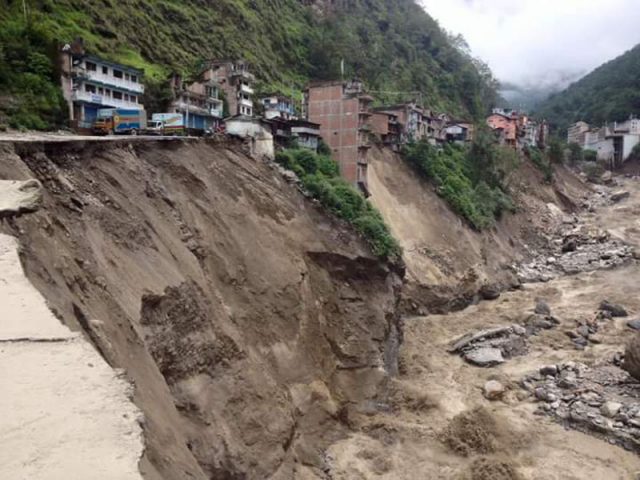
Bhote Kosi flood: Himalayan Times image of damaged slopes and houses
.
It is clear that much of the damage has been caused by erosion of the toe of slopes by the flood, and subsequent slope failures. There is also a good gallery of images here. But by far the best illustration of the damage is in this Youtube video, even though it is not in English. The journalist has followed the line of the highway up to Kodari. The damage to this very important road is startling:
.
Sadly this may not be the end of the problems. Dinanath Bhandari of Practical Action tweeted this image of forecast 24 hour accumulated rainfall in Nepal:
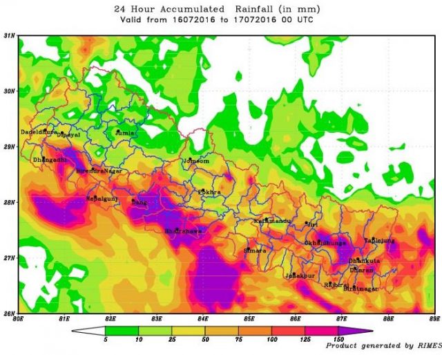
Bhote Kosi: forecast 24 hour rainfall for Nepal via RIMES
.
This is the forecast for two days time. Whilst the heaviest rain is forecast to fall in the south, large parts of Nepal may get heavy precipitation.
 Dave Petley is the Vice-Chancellor of the University of Hull in the United Kingdom. His blog provides commentary and analysis of landslide events occurring worldwide, including the landslides themselves, latest research, and conferences and meetings.
Recent Comments