
26 August 2016
Two further videos of the Kleine Gaisl rockfall in Italy
Two further videos of the Kleine Gaisl rockfall in Italy
Two further videos have now been posted to Youtube showing the Kleine Gaisl rockfall in the Dolomites of northern Italy a week ago. These seems to capture rather larger collapse events than the one that I posted a couple of days ago:
Pinopoli Clementi has posted this video, which seems to capture a big collapse involving some large boulders:
.
And the same person has posted another video, taken from a different angle, that seems to show a different collapse event:
.
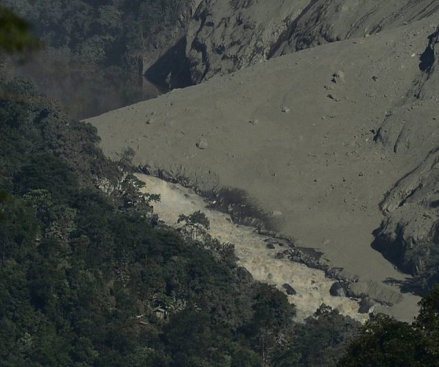
Perhaps the most impressive thing here is way that comparatively small initial failures trigger larger events downslope, creating very large landslides. These two images, just a few seconds apart, capture this beautifully. Here is a collapse of a rock section from the upper slope:
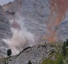
Kleine Gaisl rockfall via Youtube
.
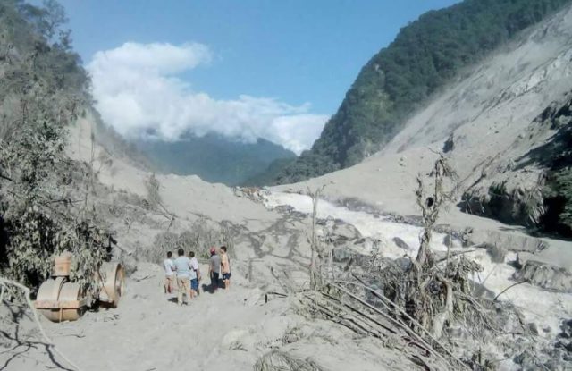
And a few seconds later the much larger rockfall that it initiated:
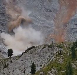
Kleine Gaisl rockfall via Youtube
.
One of the great challenges for landslide hazard assessment is being able to account for this effect, which can dramatically change the volume of the event, and thus the destructive potential and runout distance.
Thanks to Jim Falls, who highlighted these videos to me via a comment on my earlier post.
23 August 2016
Kleine Gaisl: a large rockfall in the Italian Dolomites
Kleine Gaisl rockfall
Kleine Gaisl (Piccola Croda Rossa), is a large (2859 m) mountain in the Braies Valley in the South Tyrol in the northern Italian Dolomites. At the end of last week a large rockfall occurred in a series of stages over two days between 18th and 20th August. There is a good report on Planet Mountain, although they have the volume wrong by three orders of magnitude. From other sources the estimated volume is 600,000 to 700,000 cubic metres.
Mountain guide Roman Valentini captured a part of the rockfall in a video that has been uploaded to Youtube. But note that this is not the main collapse event, as Planet Mountain notes:
The footage below was filmed by Roman Valentini, a mountain guide working for Alta Badia Guides, who was in the area on Thursday, August 18 at around 12:30. Although this is only the first, smaller part of the landslide, Valentini told planetmountain.com “It was ‘spectacular’ … I’ve never seen anything quite like it. It looked like a river in spate, with rocks half the size of houses tumbling down.”
Although the main rockfall event occurred later (the seismic data will be interesting here in order to understand the sequence of events), there is a significant collapse event at about three minutes into the video:
.
The rockfall had been anticipated as a large tension crack had been observed prior to the collapse event. Stol.it has a nice article, in German, though Google Translate does a good job, that includes an interview with the Deputy Mayor, Erwin Steiner, which also includes this good image of the source area of the rockfall:
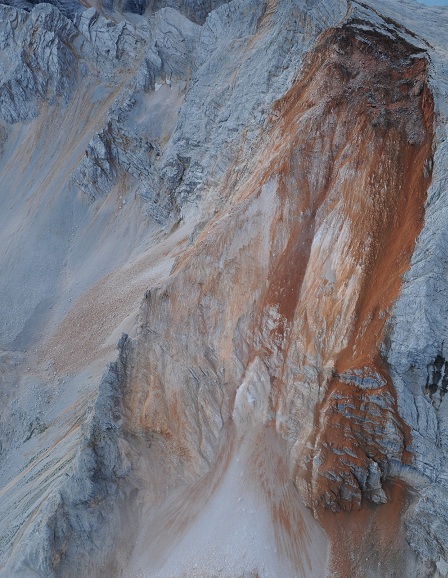
The rockfall scar on Kleine Gaisl, image by Erwin Steiner
.
Whilst another article on the same site has another view of the source zone that also captures some of the rockfall deposit::
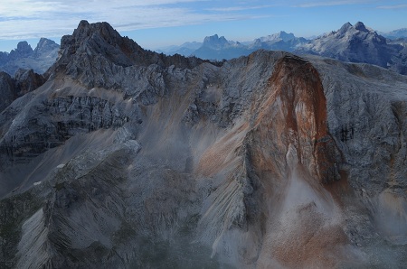
Image of the Kleine Gaisl rockfall zone, including a part of the deposit. Image by Tourismusbüro Prags
19 August 2016
The Dzongu landslide dam: an update
The Dzongu landslide dam: an update
It has been good to see that the hazards associated with the Dzongu landslide dam in India are being taken seriously by all involved, even though the water has overtopped the barrier. As I noted earlier, the hazard remains in the landscape, and at this point it is hard to know how likely a breach even might be. The Voice of Sikkim has a good review of current actions:
State Relief Commissioner cum Secretary LRDD Mr. Tsegyal Tashi convened an urgent meeting in his chamber on 18th August, 2016 which was attended by representatives of Central Water Commission, Geological Survey of India and Department of Mines and Minerals. The meeting discussed the landslide at Mantam and the mitigation measures with emphasis on ways and means for safe discharge of water from the dam site without any further loss of time. The priority is to restore the road communication and connectivity cut off areas of three GPUs in Upper Dzongu. While doing so, one must be extremely careful and proper scientific investigations must be undertaken and expert opinion sought before making any interventions at the site in order to avoid the dam bursting and flooding downstream.
This is absolutely appropriate, and an approach that is to be commended. An article in Northeast Today also notes the desire to get expert advice, whilst also emphasising the need to ensure that the affected populations are being assisted appropriately:
The district administration has taken effective and immediate relief and rehabilitation measures. Displaced families were evacuated to safer locations and relief measures were taken on war footing. The Land Revenue & Disaster Management Department has arranged airdrop of essential commodities with Air Force choppers making sorties to transport 7.2 tons of rations and relief materials to Lingdem and Tingvong. Nine persons including two sick children were also evacuated by chopper from Tingvong to Mangan. All the affected people in low lying areas of the upper reaches of the dammed area have been evacuated. The areas downstream have been put on full alert and people residing in lower lying areas en route have been advised to evacuate to safer areas.
That’s not to say that the response has been perfect, most notably there is significant criticism that the relief effort has been too little too late.
Meanwhile the Indian NRSC has released a CARTOSAT (an Indian mapping satellite) image of the landslide:
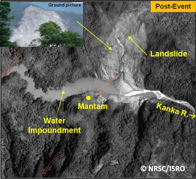
NRSC Cartosat image of the Dzongu landslide dam
.
The most interesting aspect of this may be what appears to be a secondary failure in the upper potions of the left side (on the image) of the upper part of the landslide, which has built a cone on the landslide mass that appears to be partially constraining the channel. If I was managing the site I’d be keeping a close eye on the landslide itself to determine whether further secondary failures might block the channel.
Two threats remain – first, that the flow is slowly eroding the channel bed, triggering a collapse. This can be a process that develops very slowly, and so cannot be ruled out. The second is how the dam will stand up to the next high magnitude (flood) event. Without better understanding of the dam and channel this cannot be determined.
15 August 2016
Luoyang, Henan province: first reports of a major tailings dam failure in China
Luoyang, Henan province: first reports of a major tailings dam failure in China
Over the weekend reports started to surface from China about the potential for a major tailings dam failure at the Xiangjiang Wanji Aluminium plant in Luoyang, Henan Province in China. Aluminium Insider reported on 11th August as follows:
The People’s Republic of China’s Henan Xiangjiang Wanji Aluminum Co., Ltd. has shut down its alumina refinery in Wanji on account of the potential of a dangerous red mud landslide. According to CRU, the timetable for reopening the facility is not known at this time. A source from within the country indicates that the southwest corner of its red-mud dam body is unsound, threatening a red-mud slide. The Xinan town government, which oversees the town within which the refinery is located, received a report of same and dispatched a working group to the area shortly thereafter. The government required the refinery to cease discharging red mud at once for safety reasons. At the time of the report, over three hundred residents had been evacuated to a safe location, and ten dozen police officers have been stationed nearby.
As far as I can tell there has been no official confirmation of this story. However, the AZ China Blog has now reported that the dam has indeed failed:
Around 7pm on 8th of August, Xiangjiang Wanji Aluminium’s red mud storage had a landslide accident. Xiangjiang Wanji Aluminium is a private alumina refinery … The red mud storage which had the accident is located in Dahegou Village, in Luoyang, Henan province. According to local newspaper reports, the dam wall suddenly broke and silt mixed with stones from the mountainside rushed down, and the village was totally submerged. This village is home to around 300 villagers and they were transferred in an emergency evacuation. No one was killed or injured. The villagers are living in a primary school in Xinan County temporarily. Sadly, the red mud buried many farm and domestic animals because it was too late to save them. It has been reported that the dam held about 2 million cubic meters of red mud and was about 1.5 km in length.
Most importantly, they have posted an image of the tailings landslide:
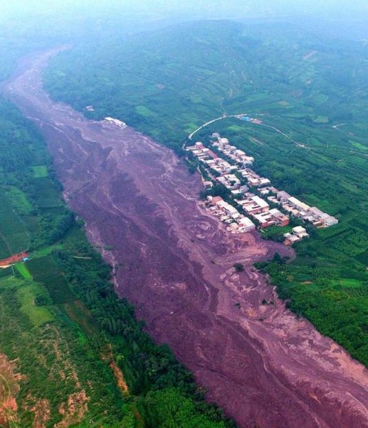
The Luoyang tailings landslide in China via AZ China
.
This Google Earth image, dated from Frebruary this year, is the reported site of the tailings dam failure:
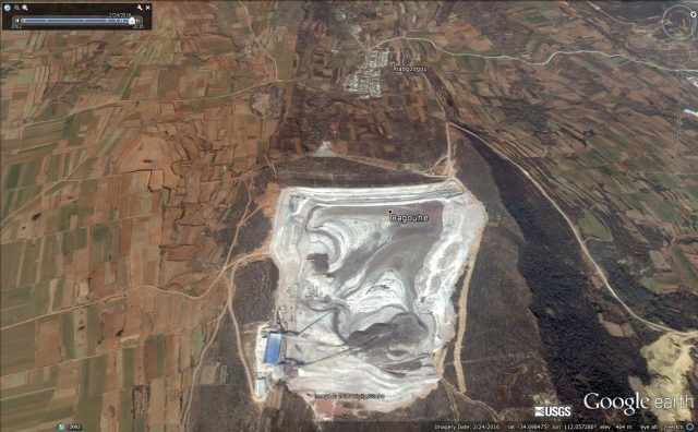
Google earth image of the site of the reported tailing dam failure at Luoyang
.
I don’t think that there is any doubt that the houses on the Google Earth image are the same as the ones in the image of the tailings landslide:
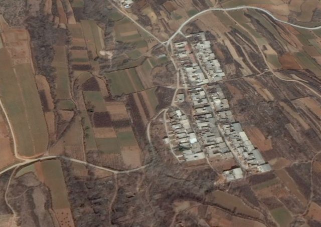
Google Earth image of the downstream area affected by the Luoyang tailings dam failure site
.
I think, therefore, that it is clear that a major tailings dam failure has occurred at this site. This is yet another disaster for the mining industry in China.
The Dzongu landslide: overtopped but not drained
The Dzongu landslide
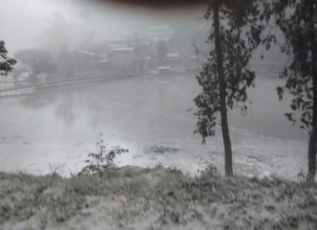
As expected the Kanaka River has now overtopped the Dzongu landslide in Sikkim, and water is flowing freely. The Darjeeling Times published this image yesterday of the landslide and the flow of water across the natural spillway:
Darjeeling Times image of the Dzongu landslide in Sikkim, showing the aftermath of the overtopping event
.
The good news is the channel appears to be eroding laterally rather than vertically at the time of this image, and that there also appears to be large boulders in the channel that may be inhibiting basal erosion. However, it is really important to stress that the danger is not over at this site. The dam could still enter a failure mode through piping, through erosion of the downward face or through basal erosion. The dam has yet to be tested in a high flow event (and this is the monsoon season). The site needs detailed assessment and monitoring, and all should be on their guard.
Meanwhile, the lack of a breach event creates another crisis as the presence of a large landslide and a lake mean that access to communities upstream is impacted. On Facebook, Bijoy Gurung has written an account of the effects that is worth a read. Part of his account is as follows:
MAROONED
One word that encapsulates Upper Dzongu and its inhabitants following the Saturday collapse of an entire hill side upon Kanaka river which dammed its flow besides Mantam, 4th Mile and spawned a 300 m lake. The sole road link has been washed away while the 4th Mile suspension bridge is somewhere beneath the nearly 70 m deep lake … Some villagers of Upper Dzongu are trekking through three dense forest hills for almost 4 to 5 hours to reach Lower Lingthem where a motorable road exists leading to Passingdong and then towards Mangan or Gangtok.ALL EYES TOWARDS THE SKY
It is beyond question for the old and children to make this punishing trek. It is beyond imagination to consider carrying goods or rations on bare backs towards the isolated villages in Upper Dzongu. Soon, the stock of food grains and essential items in the Upper Dzongu villages are going to run out. The old and ill people are going to need medical attention and medicines. Power supply is snapped and the last call from Upper Dzongu ended this morning as the mobile battery has gone dead.
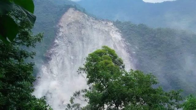
Kalimpong News has an image of the scale of the landslide:
Kalimpong News image of the Dzongu landslide
13 August 2016
Freshwater: a nice landslide video from the Isle of Wight
Freshwater, Isle of Wight
Isle of Wight Radio has a nice video, taken by a walker on the beach at Freshwater, of a cliff collapse event. The video was uploaded onto Facebook by Phil Baldwin, who was collecting fossils on the cliff face. ITV News has a nice report that provides more detail about what happened.
Phil Baldwin has also uploaded some images of the aftermath of the landslide onto his Facebook account:
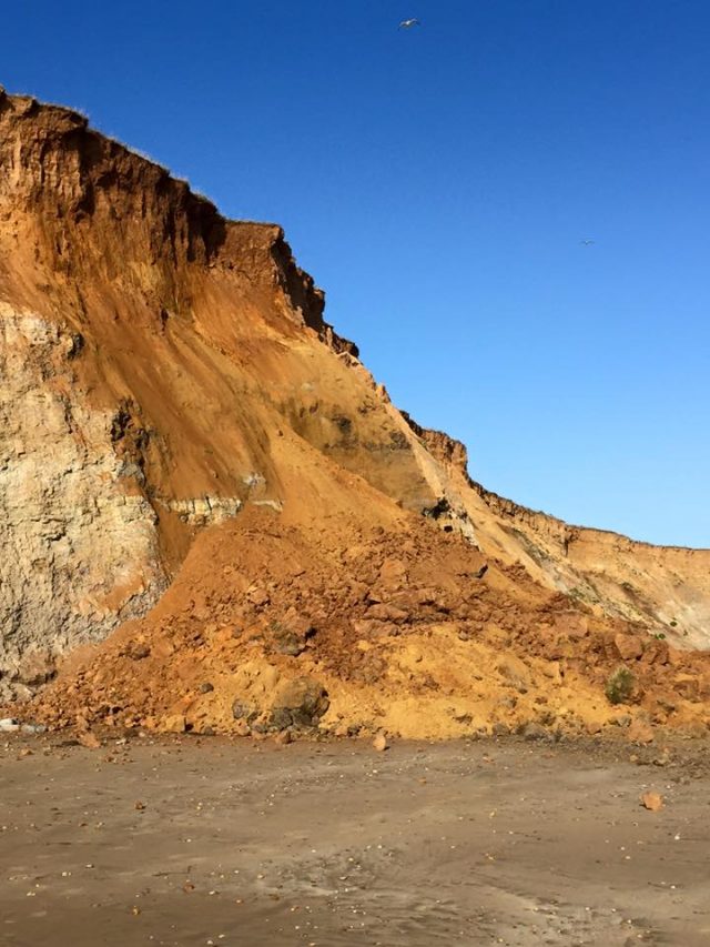
The Freshwater landslide via Phil Baldwin and Facebook
.
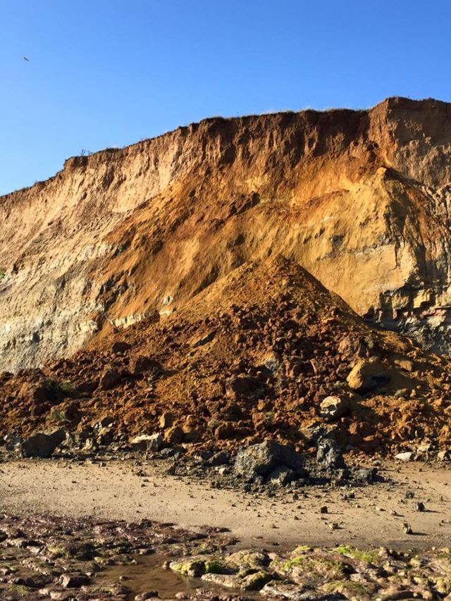
The Freshwater landslide via Phil Baldwin and Facebook
.
This area of coastline, on the southwest side of the Isle of Wight, is actively eroding. The road at the top of the cliff, known as the Military Road, has suffered numerous problems associated with landslides caused by coastal retreat. It is interesting to note though that this landslide happened in the summer when the weather appears to have been fine. Given the popularity of this area with tourists and fossil hunters, the warnings by the local council to treat the cliffs with respect are well-made.
Dzongu: a worrying valley blocking landslide in Sikkim, India
Dzongu landslide, Sikkim
News has emerged in the last 24 hours of a major valley-blocking landslide at Dzongu in Sikkim, northern India. The every-impressive and wonderful Save the Hills blog has a series of reports and images. I won’t seek to replicate them here. There is some confusion about the timing of the landslide, with suggestions that it occurred on 2nd August. The landslide, which is large, has blocked the Kanaka River completely, and a lake has started to build behind it.
Suvrat Kar pointed out this Youtube video of the dust cloud generated by the landslide:
.
These images, from Save the Hills, show the situation. This is the landslide scar:
The Dzongu landslide in Sikkim, via Save the Hills
.
And this image shows the barrier lake that has developed:
The barrier lake behind the Dzongu landslide, via Save the Hills
.
The I Love Siliguri Twitter account has posted this image of the lower reaches of the landslide, which gives an idea of the scale of the mass:
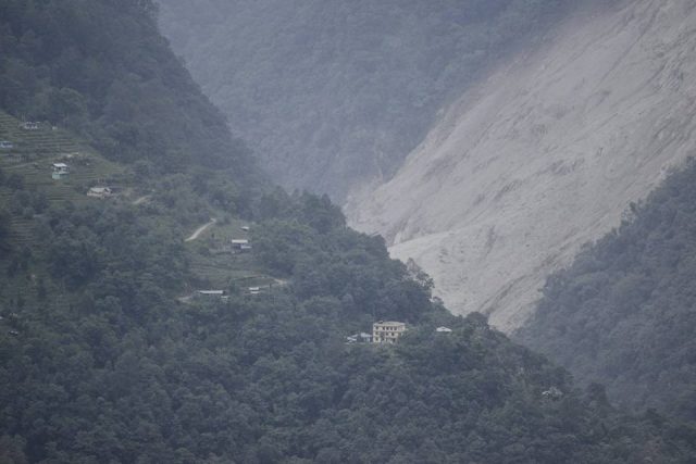
The lower part of the Dzongu landslide, via I love Siliguri twitter account
.
Whilst the Darjeeling Chronicle has this before and after image of the river (I have some doubts as this is quiet all it seems, but replicate it here for imformation):
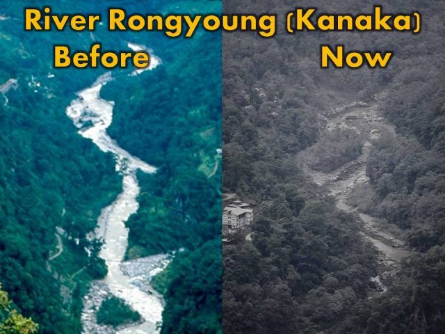
The dried up Kanaka River downstream of the Dzongu landslide, via the Dareeling Chronicle
.
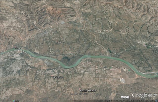
This is the site of the landslide, via Google Earth:
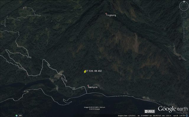
A Google Earth image of the site of the Dzongu landslide in Sikkim
.
If this is correct then that vertical extent of the landslide is about 900 metres. Suggestions are that the landslide dam is about 50 m high.
It is really hard to analyse the potential risk from this landslide dam without more information. I hope that there is a rapid assessment underway. In the meantime, there is the potential for a damaging outburst flood, meaning that communities downstream need to be extremely vigilant.
5 August 2016
The Jishi Gorge landslide, China: an earthquake-induced landslide that changed civilisation?
The Jishi Gorge landslide, China: an earthquake-induced landslide that changed civilisation?
The Jishi Gorge Landslide: in a paper in the journal Science today, Wu et al. (2016) reconstruct an ancient flood from a landslide dam breach on the Yellow River in China. This flood was reportedly an important cultural event in China as early historiographies of China, such as the Shujing (Book of Documents) and Shiji (Records of the Grand Historian) report a devastating flood on the Yellow River over 3,500 years ago. Emperor Yu the Great reportedly tamed the flood (probably actually managing the aftermath of the river changes caused by the flood), whereupon he established the first Chinese dynasty, the Xia, thus changing civilisation forever. However, many scholars see the Xia dynasty as being mythical, not helped by the fact that evidence for the Great Flood has been lacking.
In their paper, Wu et al. (2016) have identified a potential landslide dam source of the Great Flood, and have mapped and dated the associated deposits. They propose that the flood was generated by the collapse of the Jishi Gorge landslide on the Yellow River, and they have identified the potential location of the landslide. This is a Google Earth image of the site – the landslide scar is on the right (south) side in the area labelled Shaolunzi Bay. The scar is very clear, extending to the ridge:
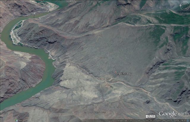
The Jishi Gorge landslide via Google Earth
.
The landslide scar is about 1.8 km from crown to the river, and about 1.5 km in width. The elevation of the crown is at about 2480 m, whilst the toe of the landslide is at about 1840 m, giving a height of the crown of about 640 m. This is a very large landslide – the authors estimate a dam volume of 40 to 80 million cubic metres. It sits on the outside of a river bend, suggesting that erosion by the flow may have been a factor is creating the opportunity for sliding. The form of the landslide is translational (i.e. planar sliding) – the outcrops near to the scar suggest that this might have been on an existing plane of weakness.
On the other side of the river is a very clear landslide deposit, as identified by Wu et. al (2016):
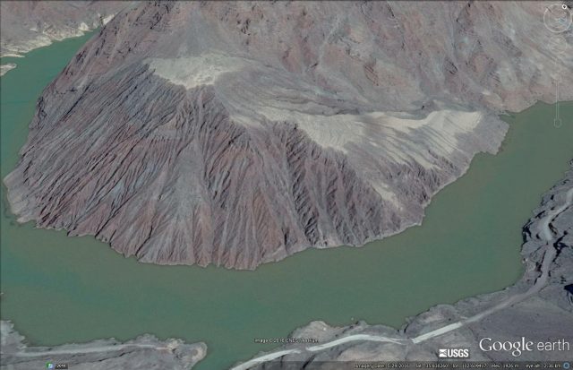
The Jishi Gorge landslide deposit via Google Earth
.
Not unusually the breach has occurred on the landslide scar side of the river. Wu et al. (2016) have mapped and dated the lake bed deposits from the landslide dam – this area on the far side of the river just upstream of the dam is identified as one:
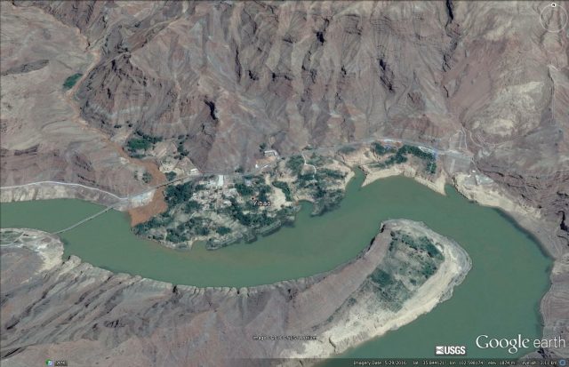
Jishi Gorge landslide dam deposits via Google Earth
.
Whilst downstream sediments deposited by the outburst floods have also been identified:
Outwash sediments from the Jishi Gorge landslide via Google Earth
.
Wu et al. (2016) suggest that the volume of water released by the breach event would have been between about 11 and 16 cubic kilometres, generating a flood with a peak discharge of about 400,000 cubic metres per second, 500 times the average discharge. As such it would have been one of the largest known river floods in the Holocene.
I suspect that the linkage between this event and the evolution of the Xia dynasty is going to be highly controversial. The presence of the remains of a very large landslide, and associated lake bed and breach flood sediments, seem reasonable. If Wu et al. (2016) are right then this is a landslide that truly changed the world.
Reference
Wu, Q et al. (2016) Outburst flood at 1920 BCE supports historicity of China’s Great Flood and the Xia dynasty. Science, 353 (6299), 579-82.
3 August 2016
Collapse of the Lord’s Rake boulder in the English Lake District
Collapse of the Chockstone boulder at the Lord’s Rake in the English Lake District
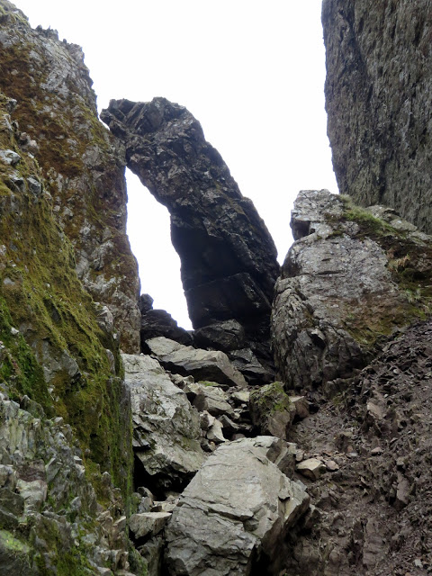
The Lord’s Rake in the Lake District is a famous steep gully that leads up to the Scafell Pike plateau, popular with climbers in this the most beautiful part of England. Part of the challenge is the presence of scree through the gully, generated by thousands of rockfalls. For well over a decade the route has been characterised by a very large boulder, known as the Chockstone, which detached from one of the rock walls near to the summit in 2001, and became wedged across the gully:
The Chockstone on the Lord’s Rake prior to the collapse, via All the Gear But No Idea
.
On Monday the Wasdale Mountain Rescue Team reported that the Chockstone has collapsed and disintegrated:
The perched block at the top of Lords Rake has fragmented and is now in bits close to where it was stuck. There are some loose boulders where it was standing. The largest bit looks to be fairly well bedded into the scree. The rake itself is just as loose as ever.
They have posted an image of the Lord’s Rake without the boulder. It’s reasonably easy to compare the location with the above image:
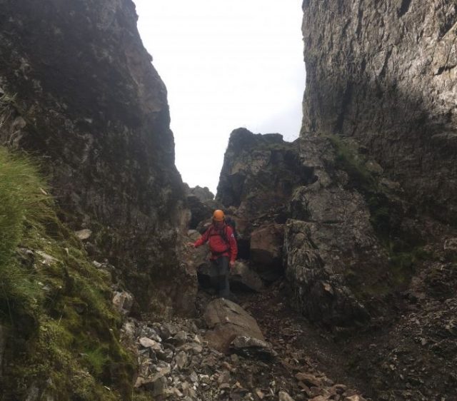
The Lord’s Rake site without the Chockstone, via the Wasdale Mountain Rescue Team
.
And an image of the a slightly forlorn remains of the boulder, which now looks like any other piece of rockfall debris:
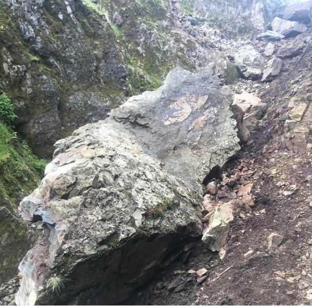
The remains of the Chockstone on the Lord’s Rake in the Lake District, via the Wasdale Mountain Rescue Team.
.
The cause and exact timing of the collapse are not clear, and it was perhaps fortunate that no-one was in the way when the rockfall happened. England has been going through a short warm spell of weather, so it is possible that the event was related to high day time temperatures. But that is mere speculation.
1 August 2016
2016 landslide losses
2016 landslide losses
We are now in the peak season for landslides globally as both the Asian monsoon and the typhoon season reach full power. I posted late last week about the impacts of the monsoon in South Asia, especially in Nepal. To date the typhoon season in the West Pacific has not been particularly powerful, but in the next 24 hours a major storm (Tropical Cyclone Nida) will make landfall in South China. The current track suggests that it will be a direct hit on Hong Kong, which could be interesting. Fortunately this is not a very powerful storm, and it is reasonably fast moving:
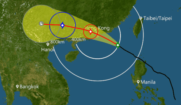
Hong Kong Observatory track forecast for Typhoon Nida
.
Nonetheless this has the potential to generate reasonable amounts of rainfall, so there may be a real landslide risk. The Hong Kong Observatory rainfall maps will be worth following for the next two days or so.
I thought this would be a good time to reflect on 2016 landslide losses to date, and to compare those with 2015. The graph below shows the number of fatality-inducing landslide that I have recorded in 2016 compared with the full year distribution for 2015. Remember that we had thought that 2015 would might a bad year due to the El Nino conditions. This did not turn out to be the case – indeed losses were surprisingly low:
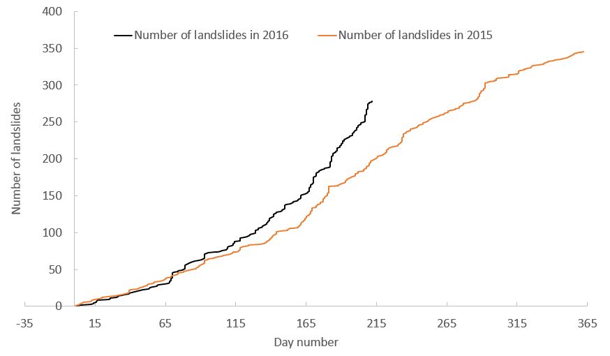
2016 landslide losses: The number of fatality inducing landslides in 2015 and 2016
.
The difference between the two years is stark. The effects of the very weak landfalling typhoon and Asian monsoons in 2015 meant that losses were comparatively low. The strong Asian monsoon this year is resulting in far higher numbers of loss inducing events.
The effect is also clear in terms of the number of fatalities. This data is always far less clear as a single landslide with very high levels of loss can dominate. But nonetheless 2016 landslide losses are far higher than those in 2015 at the same point:
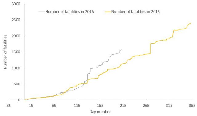
2016 landslide losses: a comparison of landslide fatalities in 2015 and 2016
.
Typically large numbers of losses occur in the period August to October, especially in China. If the current trend continues then 2016 could turn out to be a bad year, although a great deal will depend upon the remainder of the typhoon season.
 Dave Petley is the Vice-Chancellor of the University of Hull in the United Kingdom. His blog provides commentary and analysis of landslide events occurring worldwide, including the landslides themselves, latest research, and conferences and meetings.
Recent Comments