2 February 2023
The 15 December 1952 Niiortuut landslide-tsunami in central West Greenland
The 15 December 1952 Niiortuut landslide-tsunami in central West Greenland
On 15 December 1952, a landslide with a volume of about 5.9 million cubic metres detached from a slope on Niiortuut mountain on the southern coast of the Nuussuaq peninsula in West Greenland. The Niiortuut landslide triggered a tsunami that travelled through the Vaigat strait. A fisherman working close to the water in southern Nuussuaq, 10 km from the source, was killed by the tsunami, whilst the wave caused some damage to the town of Qullissat, 30 km from the source, where the run up was in the range 2.2 to 2.7 m.
This significant event is described in a new paper (Svennevig et al. 2023) recently published in the journal Science of the Total Environment. The paper is a cracking read with some really interesting conclusions.
The location of the failure is at 70.349, -53.178 – this is the site on Google Earth (the image is from 2014):-
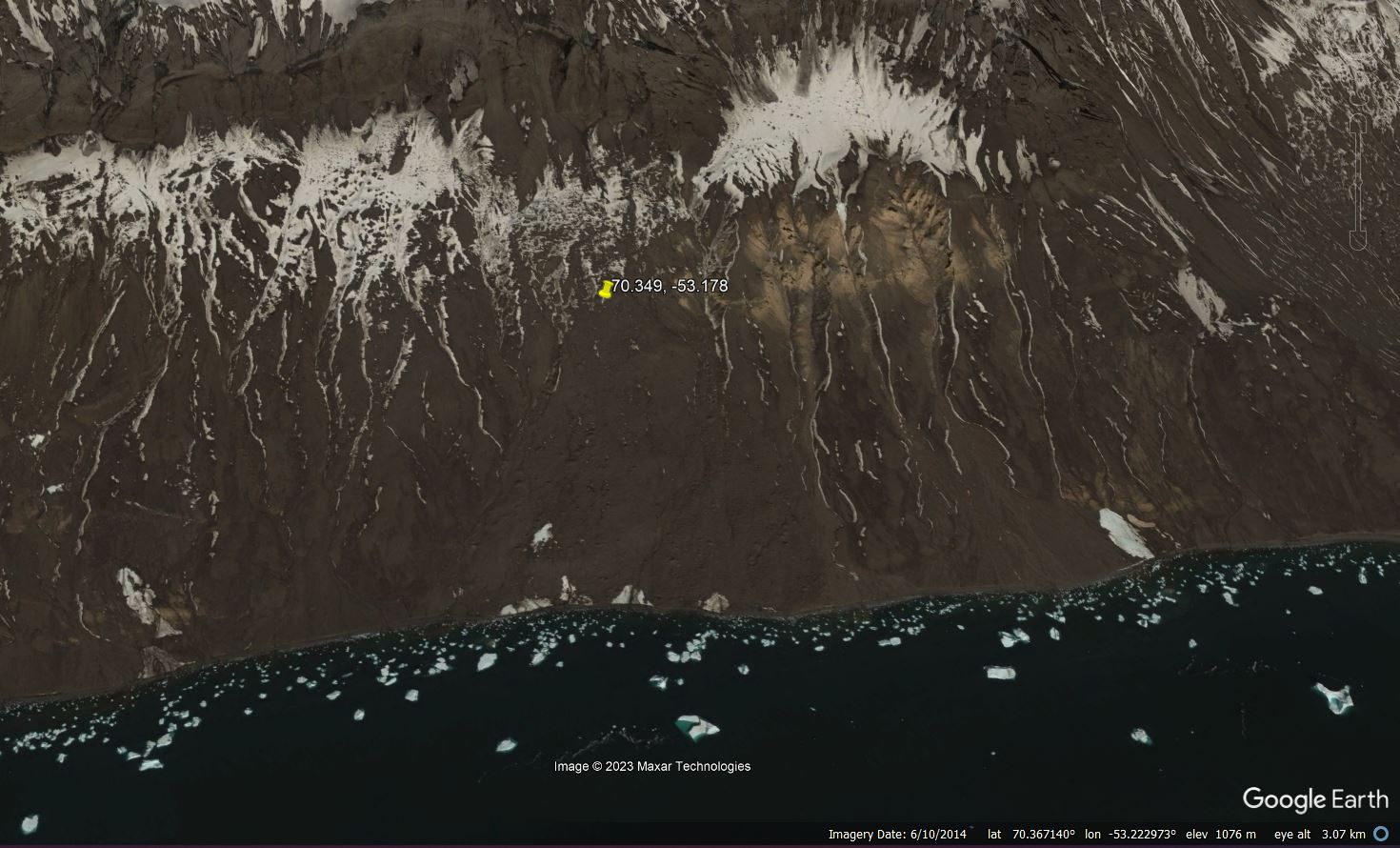
Google Earth image of the site of the 15 December 1952 Niiortuut landslide in Greenland.
.
The bedrock of the landslide site is mudstones and poorly lithified sandstones up to an elevation of 600 m, overlain by a very thick deposit of breccias and subaerial lava flows capped by basalts. According to the study of Svennevig et al. (2023) the landslide length was 2,750 metres with an elevation change of 800 m. The failure occurred in the interface between the bedrock and a thick deposit of previously-frozen talus. In the paper, they provide images both before and after the landslide:-
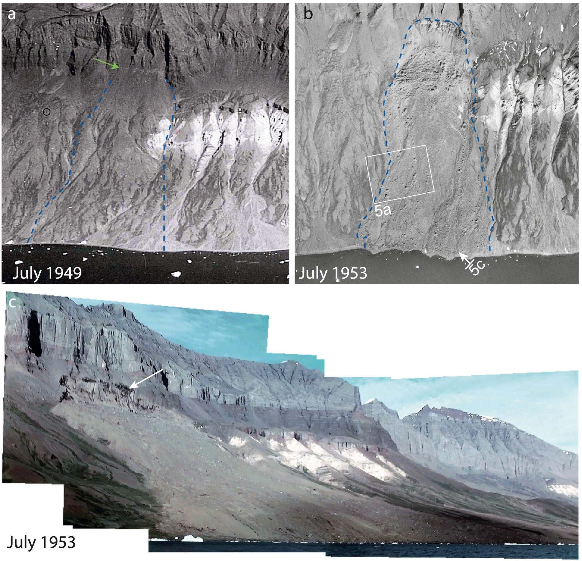
Historic images of the 15 December 1952 Niiortuut landslide in Greenland, from Svennevig et al. (2023). Original caption: Historical images. a) Extract of oblique aerial photograph recorded in July 1949 showing the coastal slope 3½ year before the landslide. Notice the light grey lineament at the top of the talus slope (green arrow) coinciding with the top of the future 1952 Niiortuut landslide. The lateral extent of the landslide is shown with blue stippled lines. b) Extract of a July 1953 1:45000 scale aerial image (not orthorectified) from ½ a year after the landslide. Outline of the landslide is indicated with blue stippled line. Positions of photos in Fig. 5 is shown. c) Photomosaic compiled of frames from a 16 mm colour film recorded on July 29th, 1953. Notice the dark colouration in the backscarp indicated with a white arrow. Viewing direction is towards the north-east.
Fortunately, the height of the tsunami appears to have been quite moderate in comparison with some other events of this type.
The really interesting aspect of this paper is that the authors demonstrate that failure was preconditioned by permafrost degradation, in line with the more recent events in 2009, 2016, 2017 and 2021. Warming in this area of Greenland initiated in the late 1910s, so by 1952 over 30 years of warming had been observed, with average Arctic temperatures having an anomaly of 1.7 °C in the period 1930–1940 compared to the period before warming started. As such, this is one of the earliest warming-induced landslides identified to date.
Svennevig et al. (2023) conclude with implications for the future:
The Niiortuut frozen debris avalanche and other recent landslides in Greenland might be a sign that permafrost is increasingly degrading, and more landslides can be expected in the future as a result of continued warming.
.
Reference
Svennevig, K. et al. 2023. Uncovering a 70-year-old permafrost degradation induced disaster in the Arctic, the 1952 Niiortuut landslide-tsunami in central West Greenland. Science of The Total Environment,
859 (1), https://doi.org/10.1016/j.scitotenv.2022.160110.
1 February 2023
The 15 September 2022 Jiujiawan landslide in Qinghai province, China
The 15 September 2022 Jiujiawan landslide in Qinghai province, China
A new paper in the journal Landslides (Wang et al. 2023) describes the 15 September 2022 Jiujiawan landslide in Qinghai province in China. This was a large rainfall triggered failure that blocked the high speed Lanzhou-Xinjiang Railway, as well as destroying a number of roads.
The location of the landslide is 36.680, 101.772 (once again the coordinates given in the paper are slightly incorrect). This is the site of the landslide in a Google Earth image collected in July 2022:-
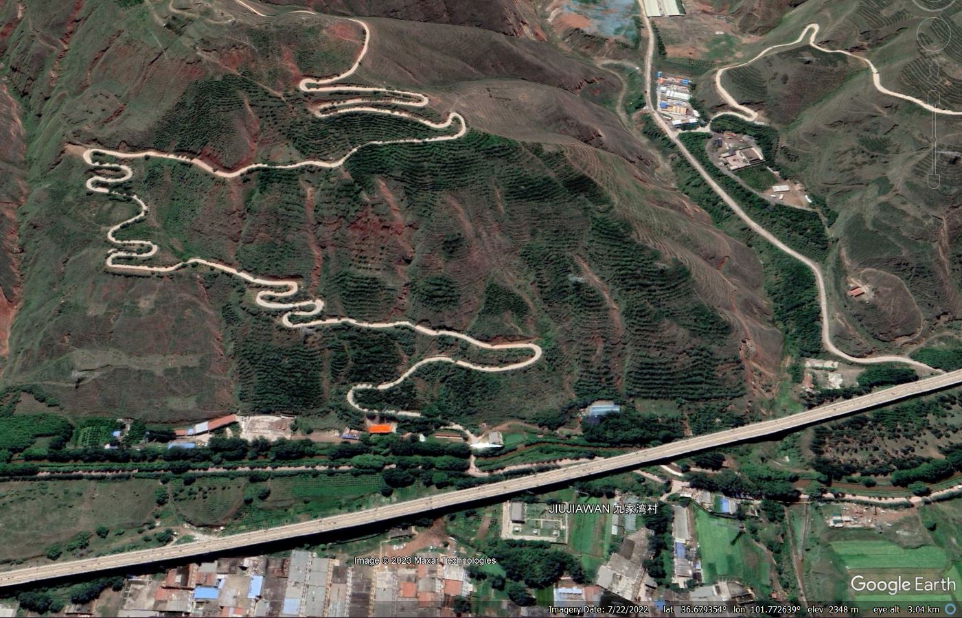
The site of the 22 September 2022 Jiujiawan landslide in China, as shown in a Google Earth image dated 22 July 2022.
.
Wang et al. (2023) includes an image of the aftermath of the landslide:-
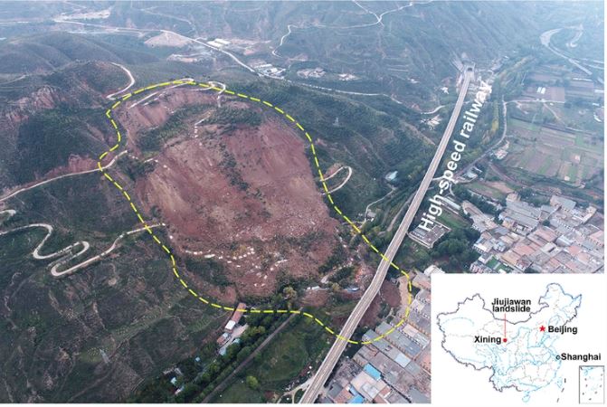
The 22 September 2022 Jiujiawan landslide in China (Wang et al. 2022, taken by Y. Chen).
.
According to the authors, the landslide occurred in sandy mudstone interbedded with gypsum at the end of an abnormal period of rainfall, although the level of precipitation on the day of the failure was low. The failure is rotational – to me it appears that there were two blocks. The first, smaller, block has disintegrated to form the debris pile at the toe of the slope. The second remains intact, with several metres of displacement, forming the large scarp at the crown of the landslide. This displaced block will require careful management.
The major economic impact of the landslide was damage to the high speed railway. As the image above shows, the track was on an elevated section at the toe of the slope. The landslide hit five of the piers, one of which was displaced 7 metres, breaking away from its foundation. The line was closed in the vicinity of the landslide; satellite images suggest that this might still be the case today.
Fortunately there were no fatalities associated with the Jiujiawan landslide.
.
Reference
Wang, F., Chen, Y. & Yan, K. 2023. A destructive mudstone landslide hit a high-speed railway on 15 September 2022 in Xining city, Qinghai province, China. Landslides. https://doi.org/10.1007/s10346-022-02016-0
31 January 2023
Palolo Valley: the boulder that came to tea
Palolo Valley: the boulder that came to tea
In Hawaii, a remarkable video has emerged of a boulder that crashed into a house in the Palolo Valley to the east of Honolulu on Sunday 29 January 2023. The video was tweeted by Max Rodriguez (@maxrrrod), a news reporter at KHON 2 News:-
A massive boulder smashed through a home in Palolo Valley almost hitting the owner inside. @KHONnews #news#breakingnews#hawaii#khon2news pic.twitter.com/KGoVLXeaDJ
— Max Rodriguez (@maxrrrod) January 30, 2023
.
He has a also tweeted an image of the aftermath:-

The aftermath of the boulder that came to tea in the Palolo Valley, Hawaii. Image tweeted by Max Rodriguez.
.
The event occurred at Palolo Avenue late on Sunday. The approximate location is 21.301, -157.795, although I am unsure as to the specific house that was impacted. This area is characterised by a steep volcanic hillside behind the houses, about 300 m in length, with a height difference of about 200 metres. The trigger of the landslide is unclear, but there has been recent heavy rainfall according to a report in Hawaii News Now.
This is not the first time that boulders have caused significant problems in Hawaii. For example, in 2002, a 26-year-old woman, Dara Rei Onishi, was killed when a boulder smashed through her house in Nuuanu.
This most recent event reminds me of the infamous Rocky, the boulder that crashed into a house in Christchurch as a result of the 2011 earthquake. More recently, in April 2021 a large boulder crashed into a house in Neustift in Austria.
It will be interesting to see how the authorities in Hawaii respond to this event in Palolo Valley, and also to see how the insurance company considers the damage. In many countries landslides are not insured on domestic policies.
.
Acknowledgement
Thanks to The Guy from Oregon (@ke7dkg) for highlighting this event on Twitter.
30 January 2023
Multiple landslides from extreme rainfall in Auckland, New Zealand
Multiple landslides from extreme rainfall in Auckland, New Zealand
In recent days Auckland and the surrounding area of New Zealand have suffered from an atmospheric river rainfall event that has been devastating, with the heaviest rainfall occurring on 27 January 2023. Met Service New Zealand tweeted about the 36 hour rainfall totals on 28 January:-
https://twitter.com/MetService/status/1619151947998846982
.
Unsurprisingly, there has been extensive flooding and large numbers of landslides. Stuff has a really good portfolio of photographs of the landslides and flood that the rainfall triggered, whilst Newstalk ZB has this image of multiple landslides in the Massey neighbourhood of Auckland:-
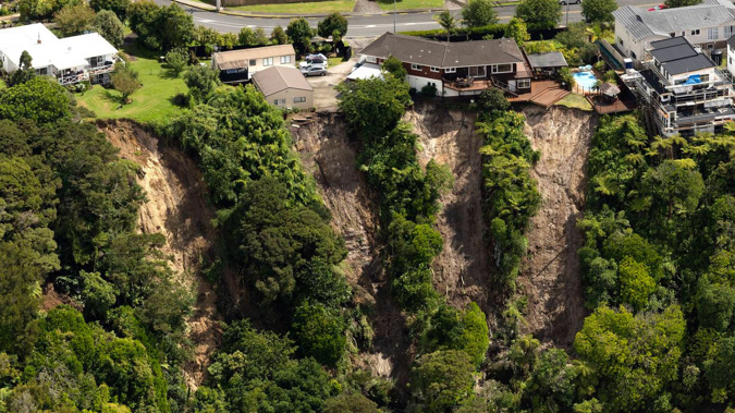
Multiple landslides in Massey, Auckland. Image by Brett Phibbs via Newstalk ZB.
.
Meanwhile at Remeura in Auckland a man was killed by a landslide that knocked a house off its foundations. Yahoo News has an image of the aftermath:-
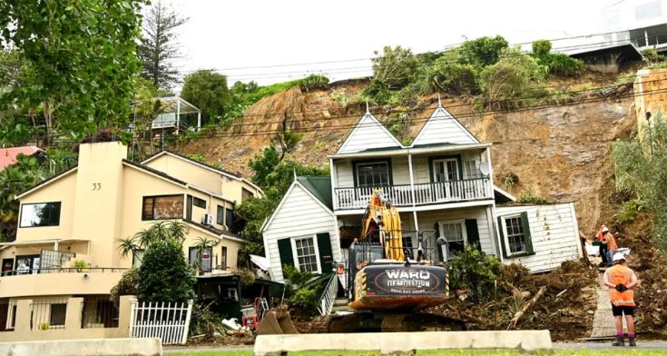
The aftermath of a fatal landslide in Remuera, Auckland. One person was killed at this site. Image by Getty via Yahoo! News.
.
Meanwhile, a large landslide has destroyed State Highway 25A across Coromandel:-
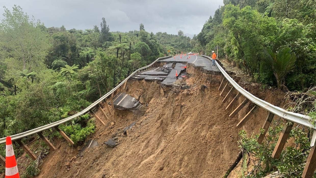
The aftermath of a large landslide that has destroyed SH25A during the extreme rainfall in the Auckland area. Image by WAKA KOTAHI via Stuff.
.
Repairing this level of damage is going to be time consuming and expensive.
As I write there are warnings of further severe rainfall in the northern part of New Zealand, with a red rainfall warning in place for Auckland, Coromandel and Northland:-
Heavy Rain Warning (Red) issued for Auckland, Coromandel, Northland https://t.co/TRR3AupBsl
— MetService Severe Weather Info (@MetServiceWARN) January 30, 2023
.
Further extreme rainfall could occur on Tuesday, with the mayor of Auckland warning that this could be even more dangerous than the rainfall that occurred on Friday. The challenge is not the rainfall total, which is likely to be considerably lower than on 27 January, but the presence of already saturated ground. This is a recipe for further landslides.
Already there is considerable soul searching occurring about the preparedness for these increasingly frequent rainfall events. A detailed review is going to be needed once the rainfall ends.
26 January 2023
The 19 July 2019 Yahuokou landslide in Gansu Province, China
The 19 July 2019 Yahuokou landslide in Gansu Province, China
On 19 July 2019, a large (3.92 million cubic metre) landslide started to develop at Dongshan Town, Zhouqu County, Gansu Province, China. This mass movement, known as the Yahuokou landslide, is described in a good paper (He et al. 2019) that has recently been published in the journal Landslides.
The failure is large – 1,920 m long over a vertical range of 550 m. The location is 33.742, 104.516 (the position given in the paper itself is unfortunately not quite correct). Rather elegantly, there is Google Earth imagery of the site captured on 31 July 2019, just a few days after the landslide occurred:-
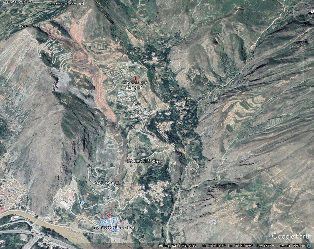
Google Earth imagery of the 19 July 2019 Yahuokou landslide in Gansu Province, China.
.
He et al. (2019) describe the impact of the landslide, noting that it destroyed roads and chicken farms; it blocked the river, causing the water level to rise; and it disrupted traffic. Movement continued for about a month.
As the image above shows, the landslide was a reactivation of an ancient landslide. The main mechanism of movement is a flow, triggered by heavy rainfall. The rate of movement was comparatively low, with failure being initiated at the crown of the slope. Movement then propagated downslope through the landslide mass.
The Google Earth imagery captures rather well the displacement of the slope, and the propagation of the landslide, given that the imagery was captured whilst movement was still developing. This image is from 31 July 2019:-
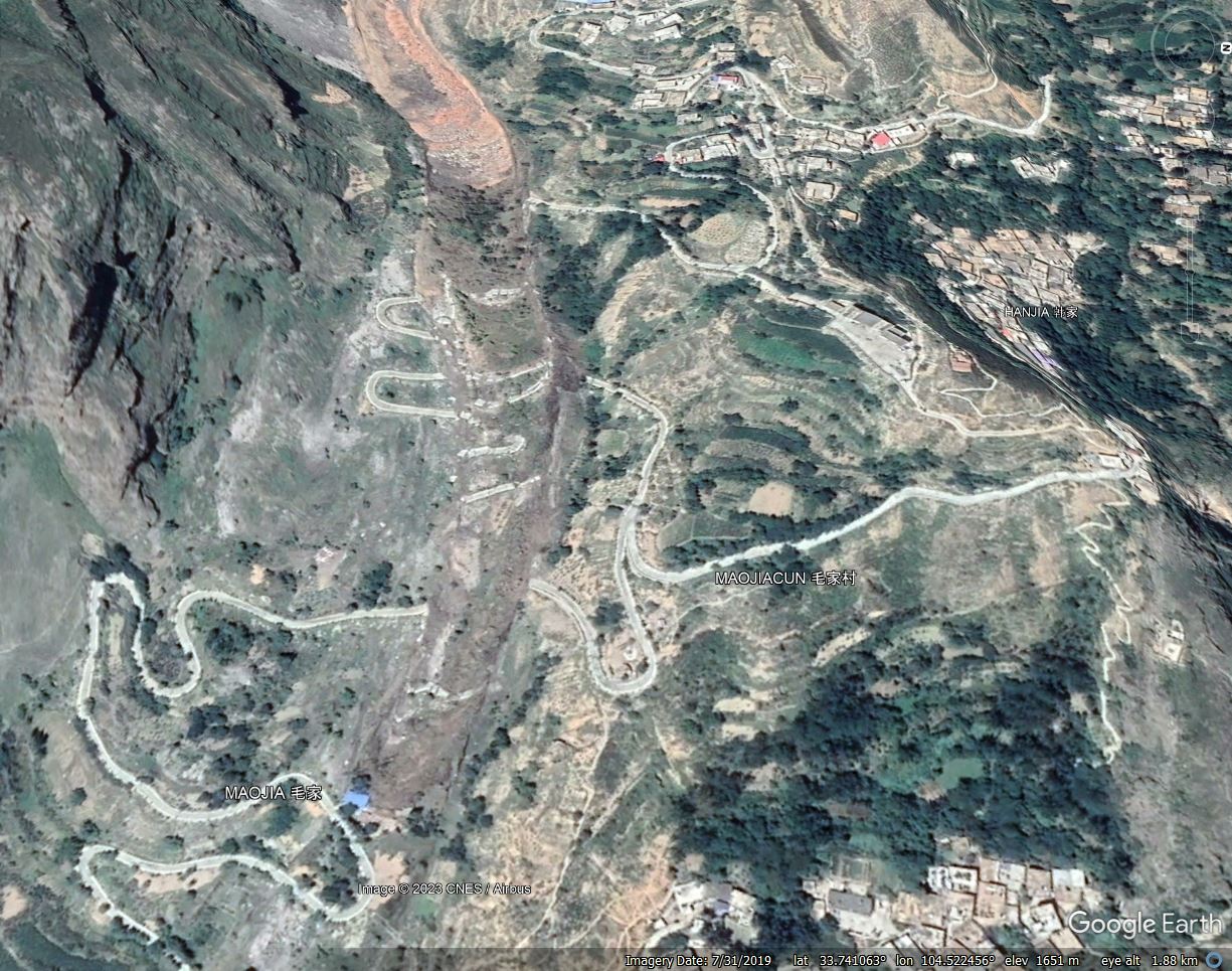
Google Earth imagery of the mid section of the 19 July 2019 Yahuokou landslide in Gansu Province, China.
.
The road provides a rather good indicator of the amount of deformation. The first (uppermost) road section has moved about 85 m. The middle section has moved about 57 metres, whilst the lower part has moved 45 metres. At the time that the image was captured the toe of the active landslide had reached the building with the blue roof, the adjacent section of road was undamaged at this point. The most recent image (from 2021) shows that the landslide subsequently propagated through this area.
He et al. (2019) have highlighted a really interesting landslide, and the availability of Google Earth imagery captured during and after the movement provides a really unusual opportunity to examine the development of a flow type failure.
.
Reference
He, Q., Guo, F., Li, R. et al. 2023. Characteristics, mobility and dynamic of the Yahuokou flow-like landslide in Zhouqu, Gansu, China. Landslides (2023). https://doi.org/10.1007/s10346-022-02000-8
25 January 2023
The 30 August 2020 debris flow at Azijue village in Sichuan Province
The 30 August 2020 debris flow at Azijue village in Sichuan Province
On 30 August 2020, a 3.2 million cubic metre debris flow struck Azijue in Sichuan province in China, killing three people and causing extensive damage to two communities, a school, the Chengdu–Kunming Railway (which was closed for 14 days) and three bridges. In a paper just published in the journal Landslides, Yan et al. (2023) have provided a comprehensive account of this interesting event.
The landslide can be clearly seen on Google Earth, located at 29.150, 102.870. This is an image from March 2016, showing the main channel and the substantial tributary down which the landslide flowed:-
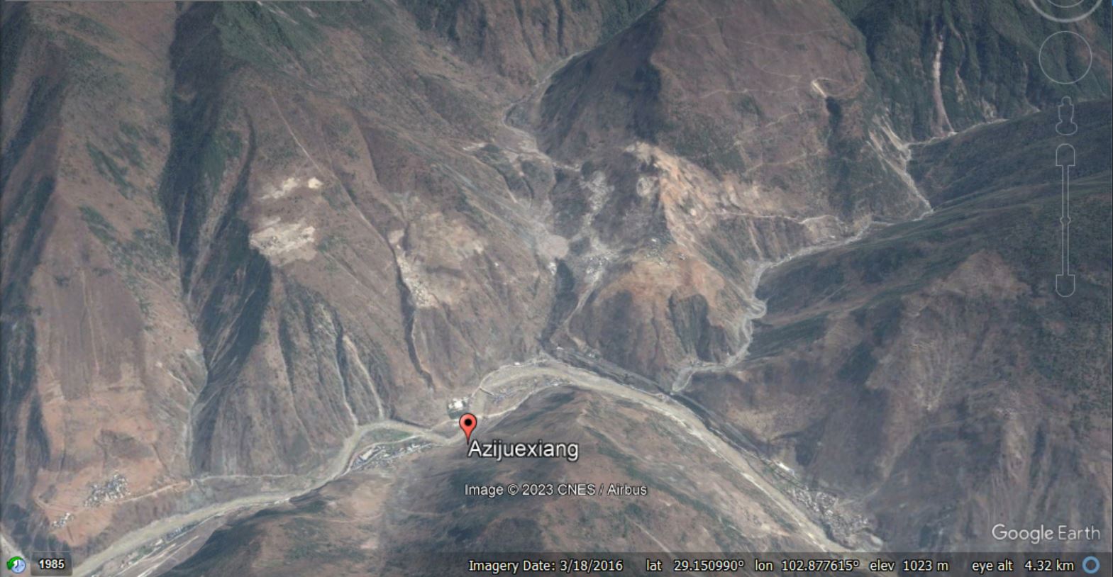
Google Earth image of the location of the Azijue debris flow, collected in March 2016.
.
Whilst this image shows the aftermath of the landslide, collected in November 2022:-
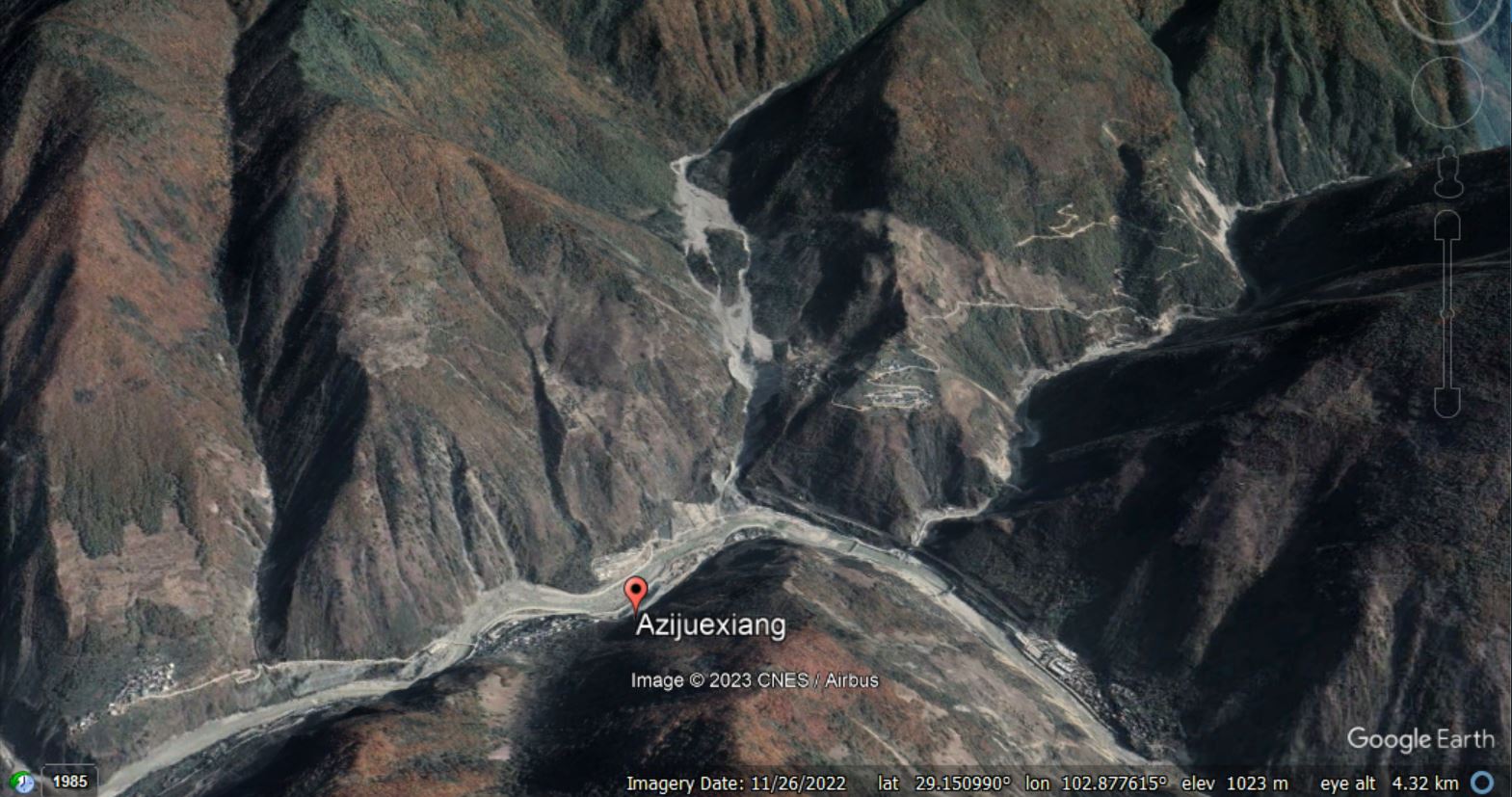
Google Earth image of the aftermath of the Azijue debris flow, collected in November 2022.
.
You should be able to compare the two images using the slider below:-


.
According to Yan et al. (2023), the landslide was triggered by about 90 mm of rainfall in a month that had already suffered abnormally high rainfall totals. But there is an unusual and interesting element to this landslide disaster. The debris flow initiated in the upper part of the catchment and travelled down the channel. En route it encountered two plateaus in the channel, which can be seen in the Google Earth image below:-
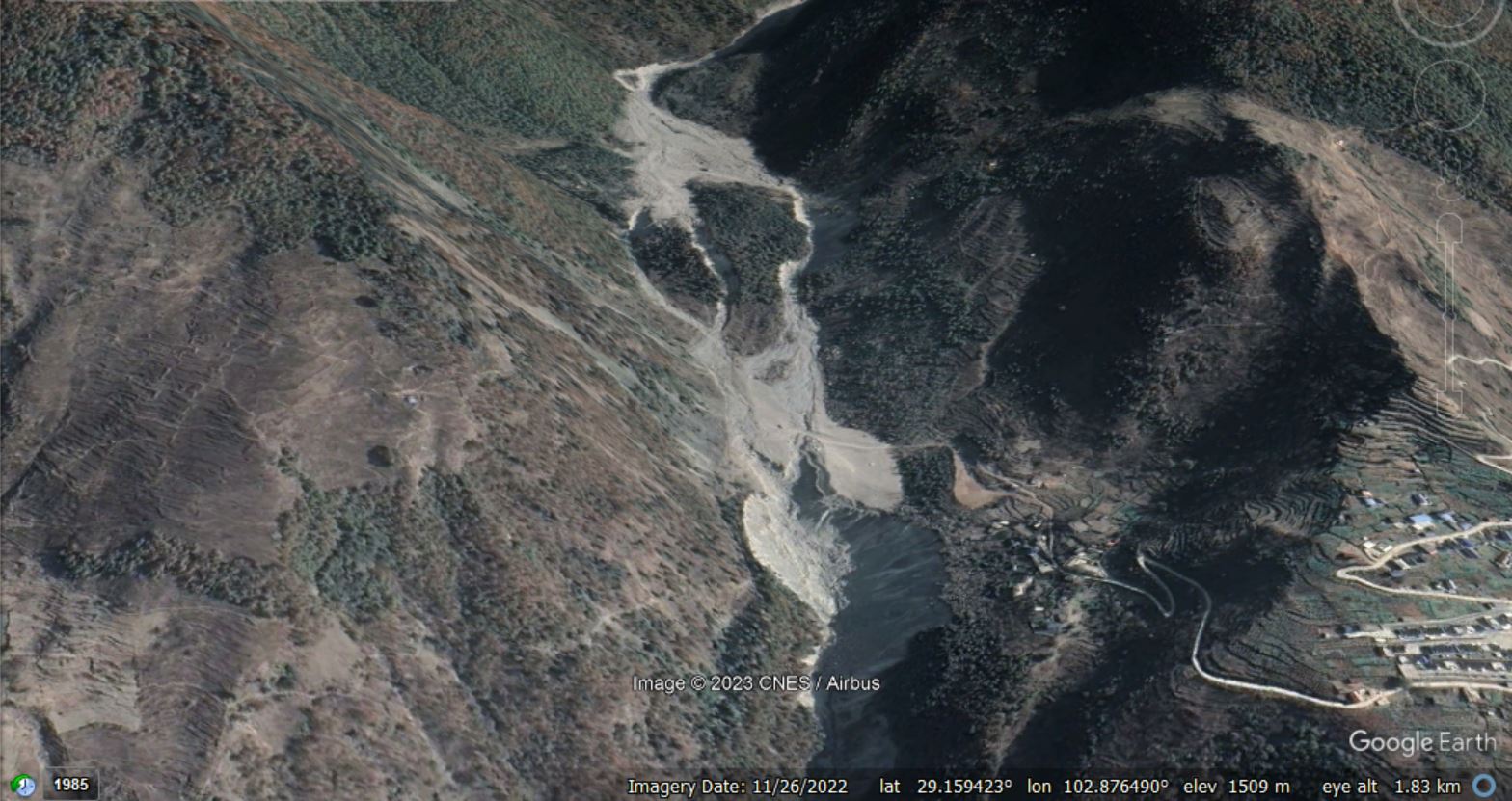
Google Earth image of the aftermath of the Azijue debris flow, showing the two plateaus in the channel, collected in November 2022.
.
These two plateaus consisted of deposits from previous flow events. The first plateau caused the flow to split into three components, which then merged again upon reaching the second plateau. But when the flow passed the downstream edge of the second plateau, a major secondary failure occurred in the channel bed, releasing a large volume of additional debris. The scar from this landslide can be seen in the lower centre part of the image above.
Yan et al. (2023) have produced a rather nice schematic diagram of the mechanism of this failure:-
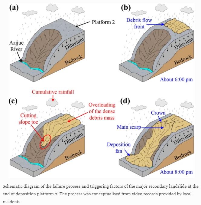
The mechanism of failure of the Azijue debris flow, from Yan et al. (2023).
.
Yan et al. (2022) attribute the damage and loss of life to this secondary landslide.
The impact of the Azijue debris flow was reduced by an effective early warning system. Yan et al. (2022) note that:
Most of the nearby residents were successfully evacuated due to a successful detection and early warning by the local government, which can be attributed to a specific microtopographic features of Heixiluo Gully. There were two wide and sub-horizontal platforms at the lower part of the gully that effectively reduced the kinetics of the debris mass before a major secondary landslide occurred at the end of the second platform over 2 h later. This 2-h interval gave enough time for most of the residents to escape from the final debris cascade.
This was a complex landslide event, most notably because of the in-channel secondary failure. Anticipating such processes is very challenging.
.
Reference
Yan, K., Wang, F., Fan, G. et al. 2023. The Azijue debris flow induced by rainfall on 30 August 2020 in Ganluo County, Sichuan Province, southwestern China. Landslides (2023). https://doi.org/10.1007/s10346-022-02022-2
24 January 2023
A coastal cliff collapse at Blacks Beach, San Diego, California
A coastal cliff collapse at Blacks Beach, San Diego, California
On 20 January 2023 a large section of coastal cliff failed at Blacks Beach in San Diego, California. The landslide was captured on a video that has been posted to Youtube by Kent Ameyaro. It is well worth viewing:-
.
There is another video of a part of the landslide on the KTVB Youtube channel:-
.
And there is a nice view of the aftermath of the failure on the CBS 8 San Diego Youtube channel:-
.
The landslide at Blacks Beach is located at 32.885, -117.253. I’ve found a nice description of the geology of this area, including this image of the sedimentary sequence at Black Beach. The Ardath Shale is described as:
“…a mix of shale, silty shale, with some beds of sandstone and conglomerate that are similar in physical appearance to some beds in the other Eocene-age rock formations. However, the Ardath Shale is dominated by steep-slope-forming shale (not the nearly vertical cliffs of the sandstone and conglomerate beds). The soft shale beds erode easier forming alcoves beneath waterfalls and is susceptible of forming slumps.”
The landslide itself is complex. The principal mechanism of failure is a deep-seated rotational failure, which goes through its main (most rapid) movement phase from about 3:00 for about 45 seconds. During this time the uplift of a shale bed at the toe develops beautifully, and the slumping at the crown of the landslide is also clear (and is evidenced by the exposure of less weathered material at the base of the cliff at the top of the slump block in the image below):-
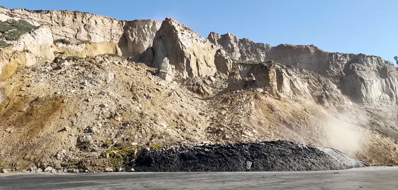
The 20 January 2022 landslide at Blacks Beach in California. Still from a video posted to Youtube.
.
In the three minutes leading up to this point multiple smaller failures and collapses can be seen. This is probably an indication that movement was occurring on the rotational shear surface, causing extensive internal deformation to the slump block, driving these smaller failures.
After the main phase of movement the landslide became more stable, but smaller collapses continued to occur. This is common in such circumstances.
Whilst the landslide occurred on a sunny day, California has endured a succession of atmospheric river events that have been associated with heavy rainfall and large waves. Thus, the landslide might be the result of higher than normal pore water pressures and/or toe erosion.
.
Acknowledgement
Many thanks to loyal reader Jonas Van Rutte for highlighting this landslide to me.
23 January 2023
An update on the landslide crisis at Joshimath
An update on the landslide crisis at Joshimath
In India, the landslide crisis at Joshimath continues to develop. As I have noted previously, the lack of clarity in terms of the situation from the authorities is remarkable. Crisis communication is hard, but there is ample evidence that a vacuum of information will be filled by misinformation. This is leading to considerable speculation, such as a suggestion that the cause might be the loss of ponds that used to be located around the town.
It appears that the landslide continues to move, with 863 buildings now showing signs of distress. Of these, 181 are considered to be unsafe. The situation for the displaced people has been exacerbated by snowfall in recent days, which of course has the potential to add water into the system in due course. Meanwhile, demolition of the worst affected buildings continues, most notably the large hotels that have been severely damaged by the landslide.
Simon Gascoin of CNRS has posted a very useful update on CESBIO Multitemp blog about the use of the Alaska Satellite Facility’s web portal (Vertex) to generate deformation time series data for the Joshimath landslide. This generates a fascinating result:-
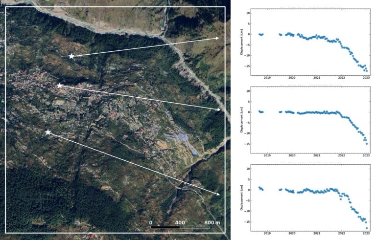
Time series of ground deformation at three locations in the Joshimath. Data generated by Simon Gascoin.
.
As Simon notes, the results support other analyses on terms of the nature and rates of movement observed. There was a sharp increase in deformation rate in October 2021, but there is a hint in the data that this might have started earlier for the point located closest to the river. This might support the suggestion that reactivation of this landslide has been triggered by erosion of the toe, but without a more detailed investigation this is conjecture.
Meanwhile, there remains a strange lack of clarity about the nature of the processes at Joshimath. Some quarters continue to report this as subsidence, which is quite misleading as it implies vertical movement. There is no real doubt that this is a landslide, with the mass slipping down the slope. At times it is good to go back to basics – Google Earth imagery clearly demonstrates that the town is built on an ancient landslide:-
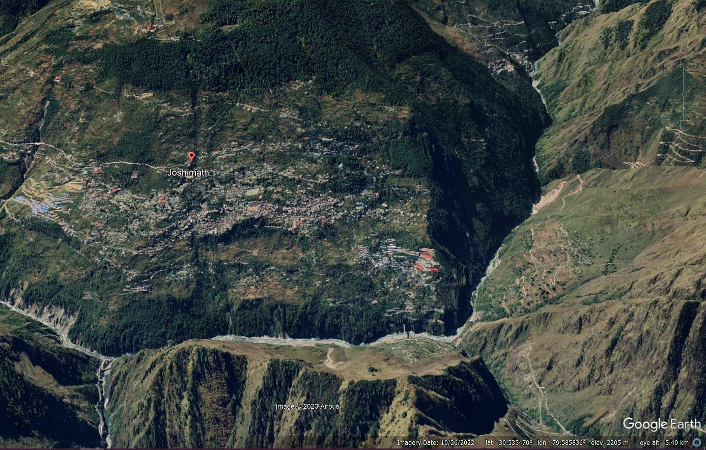
Google Earth imagery of the Joshimath landslide.
18 January 2023
Joshimath: new InSAR analysis sheds light on active deformation
Joshimath: new InSAR analysis sheds light on active deformation
In Joshimath the landslide crisis continues, imposing a big impact on the people of the town. Apparently the investigation of the landslide is ongoing, although the exact nature of this is unclear. There is a very bold statement from unnamed “scientists” that the situation is getting better. The New Indian Express reports that:-
“The land of the land submergence area in Joshimath is trying to stabilise,” the scientists believe. However, it will take some more time.
As soon as the summer starts, there will be a positive change in the situation. “The flow of water in JP Colony of Joshimath, which was happening at a speed of 10 litres per second, is now happening at 1.9 litres per second, which is comforting,” said scientists, who didn’t want to be named.
This is slightly odd. First, the summer is a long way hence, and second the summer will bring monsoon rainfall, which is unlikely to help (although it will not necessarily have an adverse effect). Finally, of course, the land is not trying to do anything except obey the laws of physics.
More importantly, we now have additional insight into the landslide from a new InSAR analysis undertaken using the Sentinel-1 instrument. This has been undertaken by renowned scientists from AUTh (Aristotle University of Thessaloniki) and CNRS-EOST (Centre National de la Recherche Scientifique / Ecole et Observatoire des Sciences de la Terre / Strasbourg) using the SNAPPING PSI Full Resolution service. The work has been released online and is freely available, with further analyses under way.
The team has produced two sets of analyses, including a times series for the movement of the slopes. The first examines movement over the period from January 2018 to 31 December 2022:-
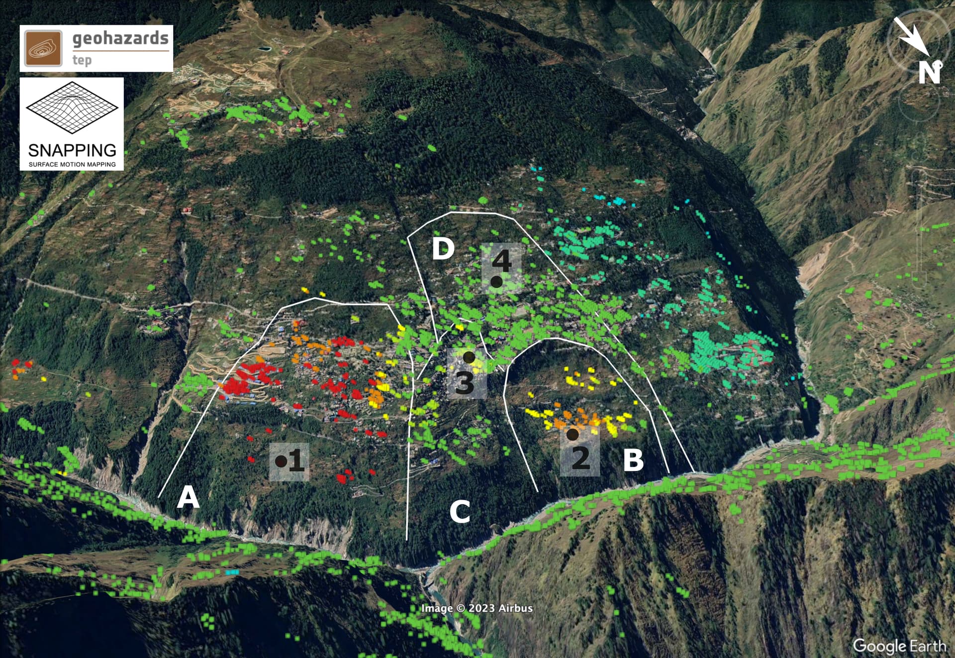
3-Dimensional view of the Joshimath slope with the SNAPPING Full Resolution PSI results overlaid (background Google Earth). The location of the active units (A, B, C, D) are delimited by white lines. The location of selected PSI targets 1, 2, 3 and 4 are also indicated. Image posted online on the gep-blog.
.
This diagram clearly shows the various landslide units upon which the town is built, and the movement patterns that they display in the long term. It confirms that the deformation is sliding, not subsidence, as expected.
A really important element of this work is that the team has produced a time series plot for points shown on the diagram above:-

SNAPPING-derived LoS displacement time series on four points over the Joshimath slope for the period 01/2018-12/2022. The temporal evolution of surface motion among the various slope units follows a complex pattern, with different displacement rates. Image posted online on the gep-blog.
.
There are a few things to note here. First, in the long term the different parts of the landslide complex are moving at different rates, which is not unusual. Point 1 is showing large displacements – almost half a metre with continuous creep, although the rate clearly fluctuates with time (this is similar to the results we got for the Utiku landslide in New Zealand for example). Other parts of the complex are moving more slowly, and indeed the point highest up the slope is not moving.
Point 3 shows a significant change in movement rate in late 2021.
The second analysis undertaken by the team examines movement over the last few weeks:
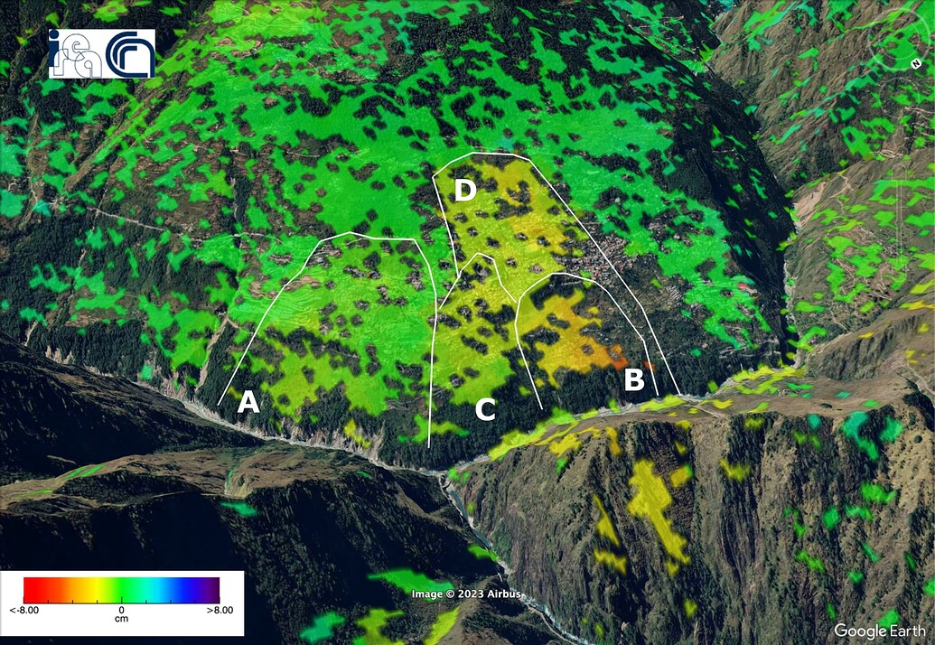
Unwrapped differential interferogram computed with the P-SBAS service for the Sentinel-1 ascending track 129 between the acquisitions of December 31, 2022 and January 12, 2023. Unwrapped differential interferogram provides the displacement of the ground in the LoS direction between two acquisitions. The orange and red colors indicate motion far away from the satellite corresponding to the downhill motion of the slope. Contains modified Copernicus Sentinel-1 images, 2022-2023. Image posted online on the gep-blog.
.
The analysis shows that three portions of the landslide complex are currently moving, with the highest rates towards the lower part of the slope. The boundaries of the movement coincide with the margins of the landslide blocks identifiable from Google Earth. We would expect to see some of the greatest amounts of building damage occurring around these margins. Thus, it is really interesting to compare the above diagram with the map posted to Twitter by Thiyagarajan J (@jThiyagu) that shows the location of the wards damaged by the landslide:-
https://twitter.com/jThiyagu/status/1612090648982851585
.
There is a strong coincidence, which suggests that these analyses are starting to pin down in more detail the nature of the landslide problem at Joshimath.
Movement of landslide complexes such as this is very complex, and we would expect to changes in the rate occurring through time. Thus, great care is going to be needed in interpreting short duration time series data. But, the bottom line is that this slope is unlikely to achieve permanent stability in its current physical state without significant engineering intervention. The current crisis will abate at some point, but the underlying chronic problem, whatever the cause, is likely to remain. That is not to say that all is lost by any means, the immediate crisis will pass, but action is likely to be needed.
.
Acknowledgement
Many thanks to colleagues from AUTh (Aristotle University of Thessaloniki) and CNRS-EOST (Centre National de la Recherche Scientifique / Ecole et Observatoire des Sciences de la Terre / Strasbourg) for making this analysis available online.
17 January 2023
Joshimath – continued development of the landslide
Joshimath – continued development of the landslide
The controversy around the Joshimath landslide crisis has continued to develop over the past week. Most importantly, there is clear evidence that the landslide itself is still moving, although the magnitude of those movements is unclear. The number of buildings that have developed cracks has increased to 849, resulting in the displacement of about 800 people from 237 families. The Times of India reports that further demolitions of buildings are planned:-
In a significant development, the Uttarakhand government on Monday decided to “mechanically demolish” structures at Jaypee Residential Colony in Joshimath that cannot be retrofitted or repaired to reduce the burden on the slope said to be accountable for the situation in the town. This would be the second major demolition exercise after the administration a few days ago began to raze two of Joshimath’s biggest hotels.
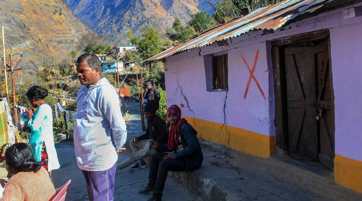
A house marked as being unsafe in Joshimath. Image from The Indian Express.
.
Demolishing buildings to maintain public safety is sensible where there is little chance that they can be recovered. However, I am somewhat skeptical of the argument that this will reduce the burden on the slope in any meaningful way.
Last week I noted that the handling of the communications around this landslide is a case study in poor disaster communication. Sadly, this situation continues. I noted that the ISRO report about Joshimath had been removed from the internet (although an archive version is still available) – The Indian Express reports that the National Disaster Management Agency (NDMA) ordered that it was removed, and has also instructed that a dozen other agencies are banned from speaking to the media about the crisis. An article in the Deccan Herald notes, correctly in my view, that this is counter-productive.
There is some sense in controlling information about the crisis to ensure that the information that reaches the public is of a high quality. However, there appears to be a vacuum of factual information about Joshimath, which will inevitably lead to anger, conspiracy theories and misunderstandings. This is so very unhelpful. If the NDMA wishes to control the flow of information about Joshimath then surely it should be providing daily updates on the known facts and the ongoing work to understand the failure.


 Dave Petley is the Vice-Chancellor of the University of Hull in the United Kingdom. His blog provides commentary and analysis of landslide events occurring worldwide, including the landslides themselves, latest research, and conferences and meetings.
Recent Comments