
2 February 2023
The 15 December 1952 Niiortuut landslide-tsunami in central West Greenland
Posted by Dave Petley
The 15 December 1952 Niiortuut landslide-tsunami in central West Greenland
On 15 December 1952, a landslide with a volume of about 5.9 million cubic metres detached from a slope on Niiortuut mountain on the southern coast of the Nuussuaq peninsula in West Greenland. The Niiortuut landslide triggered a tsunami that travelled through the Vaigat strait. A fisherman working close to the water in southern Nuussuaq, 10 km from the source, was killed by the tsunami, whilst the wave caused some damage to the town of Qullissat, 30 km from the source, where the run up was in the range 2.2 to 2.7 m.
This significant event is described in a new paper (Svennevig et al. 2023) recently published in the journal Science of the Total Environment. The paper is a cracking read with some really interesting conclusions.
The location of the failure is at 70.349, -53.178 – this is the site on Google Earth (the image is from 2014):-
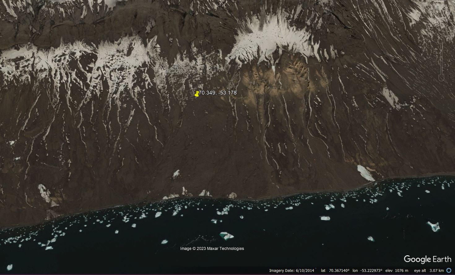
Google Earth image of the site of the 15 December 1952 Niiortuut landslide in Greenland.
.
The bedrock of the landslide site is mudstones and poorly lithified sandstones up to an elevation of 600 m, overlain by a very thick deposit of breccias and subaerial lava flows capped by basalts. According to the study of Svennevig et al. (2023) the landslide length was 2,750 metres with an elevation change of 800 m. The failure occurred in the interface between the bedrock and a thick deposit of previously-frozen talus. In the paper, they provide images both before and after the landslide:-
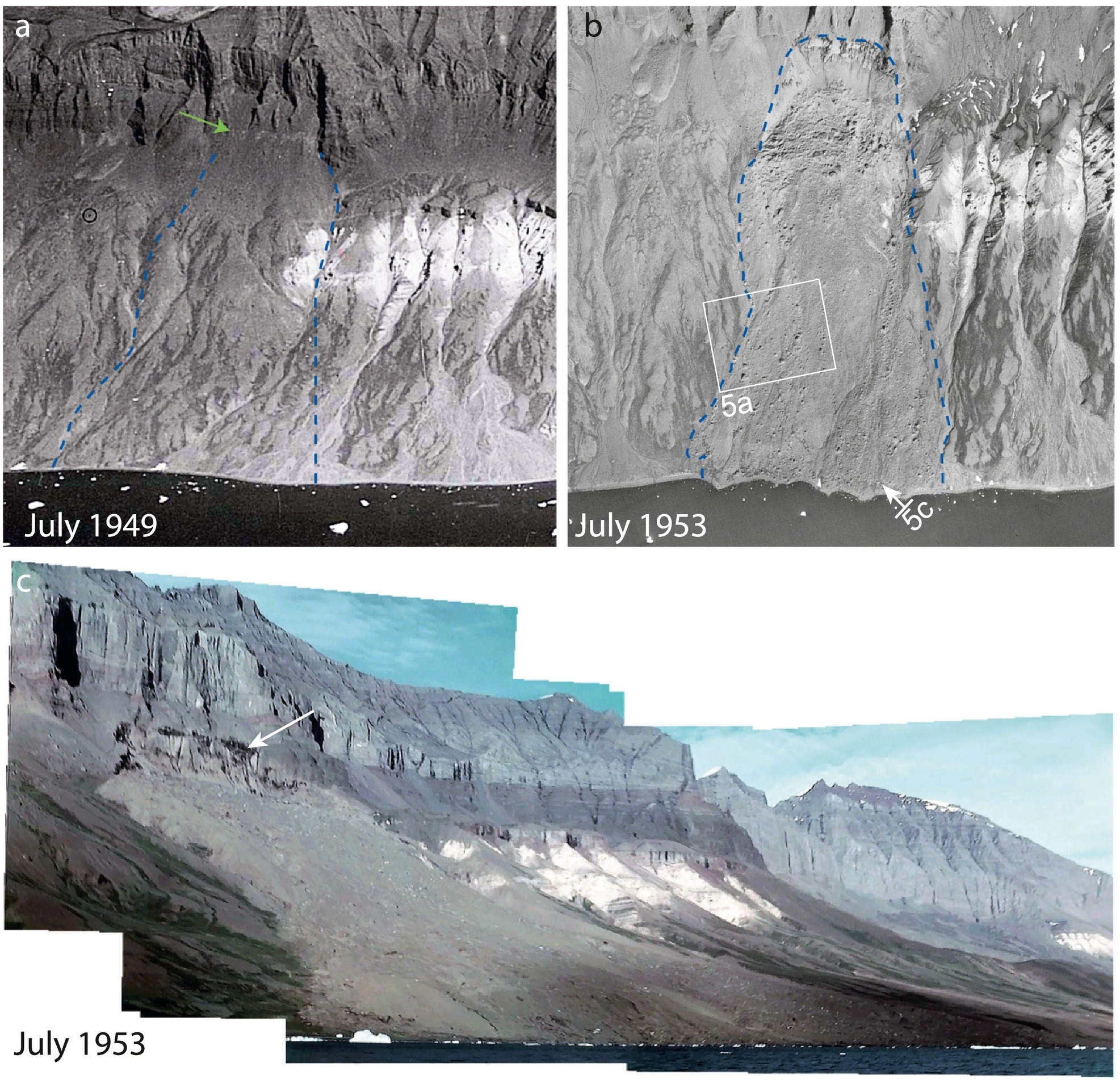
Historic images of the 15 December 1952 Niiortuut landslide in Greenland, from Svennevig et al. (2023). Original caption: Historical images. a) Extract of oblique aerial photograph recorded in July 1949 showing the coastal slope 3½ year before the landslide. Notice the light grey lineament at the top of the talus slope (green arrow) coinciding with the top of the future 1952 Niiortuut landslide. The lateral extent of the landslide is shown with blue stippled lines. b) Extract of a July 1953 1:45000 scale aerial image (not orthorectified) from ½ a year after the landslide. Outline of the landslide is indicated with blue stippled line. Positions of photos in Fig. 5 is shown. c) Photomosaic compiled of frames from a 16 mm colour film recorded on July 29th, 1953. Notice the dark colouration in the backscarp indicated with a white arrow. Viewing direction is towards the north-east.
Fortunately, the height of the tsunami appears to have been quite moderate in comparison with some other events of this type.
The really interesting aspect of this paper is that the authors demonstrate that failure was preconditioned by permafrost degradation, in line with the more recent events in 2009, 2016, 2017 and 2021. Warming in this area of Greenland initiated in the late 1910s, so by 1952 over 30 years of warming had been observed, with average Arctic temperatures having an anomaly of 1.7 °C in the period 1930–1940 compared to the period before warming started. As such, this is one of the earliest warming-induced landslides identified to date.
Svennevig et al. (2023) conclude with implications for the future:
The Niiortuut frozen debris avalanche and other recent landslides in Greenland might be a sign that permafrost is increasingly degrading, and more landslides can be expected in the future as a result of continued warming.
.
Reference
Svennevig, K. et al. 2023. Uncovering a 70-year-old permafrost degradation induced disaster in the Arctic, the 1952 Niiortuut landslide-tsunami in central West Greenland. Science of The Total Environment,
859 (1), https://doi.org/10.1016/j.scitotenv.2022.160110.
 Dave Petley is the Vice-Chancellor of the University of Hull in the United Kingdom. His blog provides commentary and analysis of landslide events occurring worldwide, including the landslides themselves, latest research, and conferences and meetings.