
13 January 2023
Joshimath: ISRO InSAR data reveals the scale of the issue
Posted by Dave Petley
Joshimath: ISRO InSAR data reveals the scale of the issue
In the last 24 hours there has been a significant development in our understanding of the landslide problems at Joshimath in northern India. Yesterday, the ISRO had released a document that provides the results of two sets of InSAR analyses for the town. This was made available on the NRSC website, but frustratingly (and slightly bizarrely) it now seems to have been removed. There are images from that report on several news channels in India though, so its disappearance is quite weird.
One analysis examined deformation in the Joshimath area between April and November 2022, showing about 9 cm of movement over the seven month period. This is the resulting diagram:-
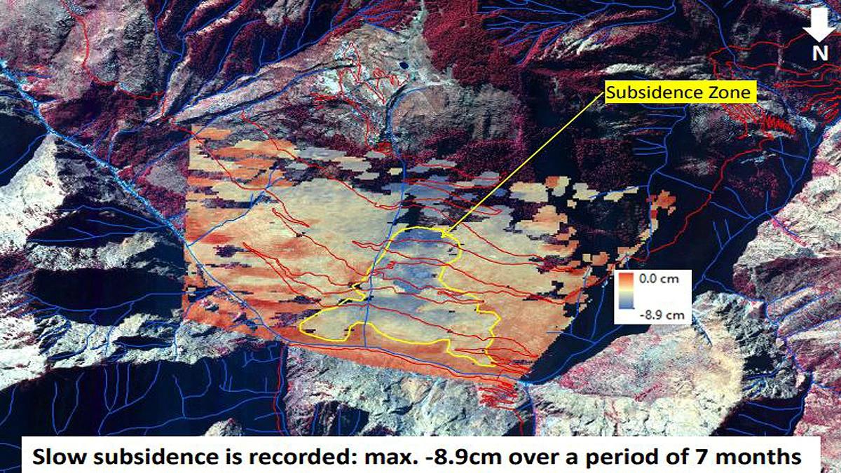
ISRO InSAR map of deformation at Joshimath over a seven month period to November 2022.
.
The second analysis examined deformation between 27 December 2022 and 8 January 2023:-
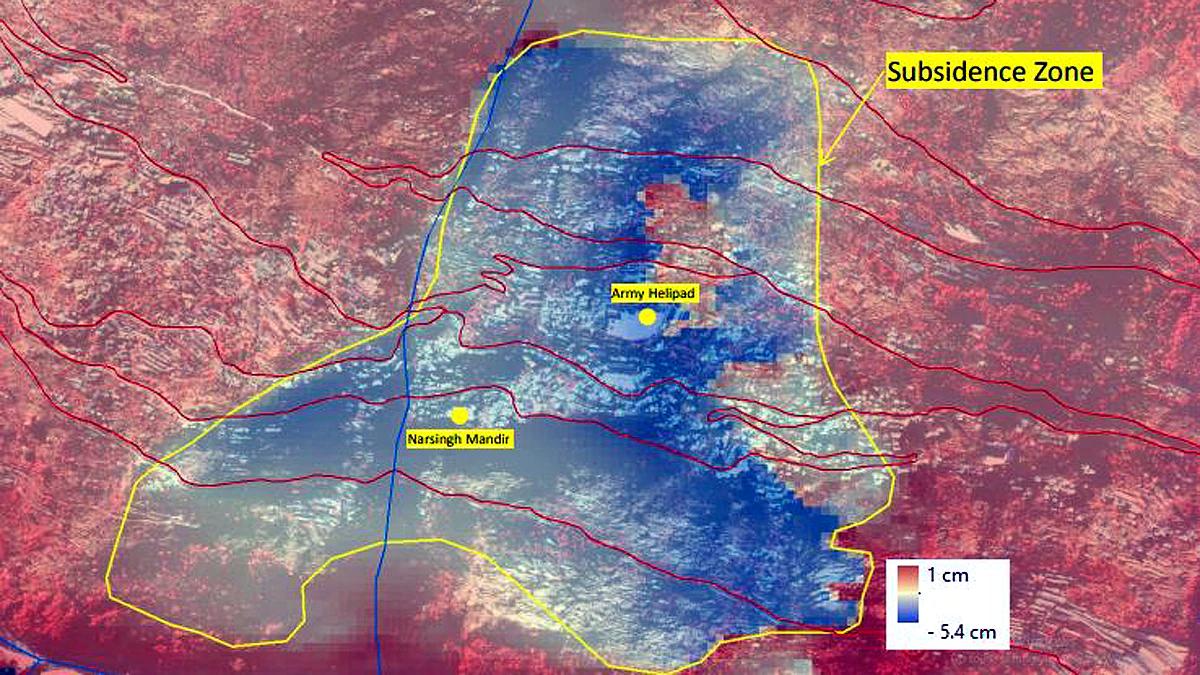
ISRO InSAR map of deformation at Joshimath over the period from 27 December 2022 to 8 January 2023.
.
Now, I think it is important to put three caveats on this analysis. First, InSAR measures line of sight movement, not absolute deformation. Thus, to interpret the data properly it is essential to understand the line of sight but, with the document no longer available, this is not clear. Second, this is labelled as subsidence, but that is potentially misleading. The movement is clearly landslide movement, and so is likely to be parallel or subparallel to the slope (whereas subsidence might be interpreted as being vertical). Third, the magnitudes of deformation do not seem to conform to observations on the ground. Whilst not trivial, 5.4 cm of movement is insufficiently large to cause the damage seen. Images such as the one below suggest deformation that is much greater than this:-
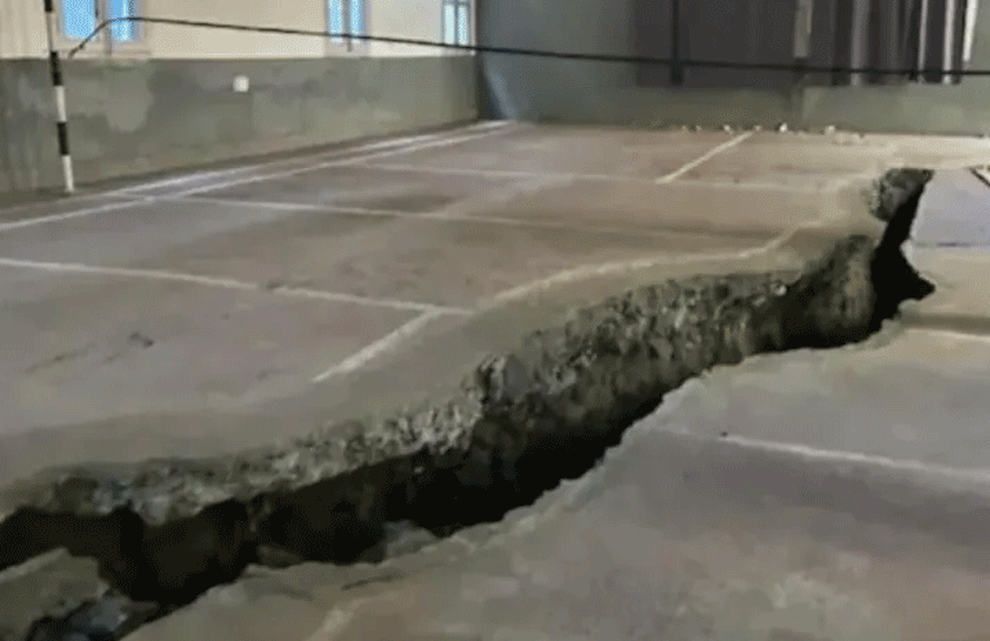
A tension crack at Joshimath. Image by The News Himachal.
.
I am unsure as to the cause of this anomaly – it could be the line of sight issue noted above, or the consequence of an initial analysis, or maybe the largest deformations occurred before 27 December.
However, the analyses provide key information. This appears to be a conventional landslide, almost certainly a reactivation of a part of the existing relict failure. The landslide is affecting the main part of the town, and extends close to the toe of the slope (the InSAR data may be unreliable in the very steep sections of slope close to the river). This might indicate that an element of the issue is toe erosion, raising the intriguing prospect that the Chamoli debris flow might have played a role. Some of the worst affected buildings, such as the two hotels that are being demolished, appear to be in the area of the lateral scarps. This is common.
The fact that the landslide is affecting the town and not the surrounding areas might hint that local factors – slope cutting, poor water management, inadequate engineering – could be playing a key role in the instability.
Of course the most important implication is that many properties at Joshimath are at risk. There are reports that the problem is continuing to get worse, with 723 buildings now considered to be unsafe.
Finally, there is a very interesting proposed paper on the NHESS website (Sundriyal et al., for comment 2023), submitted in late December, that considers the problems at Joshimath. This paper is open for comments. The paper highlights the state of instability and indicates that large amounts of deformation (in the order of metres) are possible. If this were to occur then a very large number of buildings in the town will be lost.
.
Reference
Sundriyal, Y., Kumar, V., Chauhan, N., Kaushik, S., Ranjan, R., and Punia, M. K. in review 2023. Brief communication on the NW Himalayan towns; slipping towards potential disaster, Natural Hazards and Earth System Sciences [preprint], https://doi.org/10.5194/nhess-2022-296, in review.
 Dave Petley is the Vice-Chancellor of the University of Hull in the United Kingdom. His blog provides commentary and analysis of landslide events occurring worldwide, including the landslides themselves, latest research, and conferences and meetings.
AGREE WITH YOU Chennu ! Yr observation is very apt – “he fact that the landslide is affecting the town and not the surrounding areas might hint that local factors – slope cutting, poor water management, inadequate engineering – could be playing a key role in the instability.
ADD THE ANTHROPOGENIC FACTORS caused by the humans – ever increasing errors – maladmin and mismanagement – NOT TAKING INTO CONSIDERATION EARLIER WARNINGS IN OF ORGANISATIONS LIKE GSI FROM TIME TO TIME, CONTINUOUS LOADING OF SLOPE APRONS AND PLAINS WITH NEW BUILDINGS AND PARTICULARLY MULTI-STOREY STRUCTURES ON LANDSLIDE PRONE SLOPES ; NOT OBSERVING BUILDING CODES AND ISI SPECIFICATIONS, NOT KEEPING IN FOCUS SEISMIC SIGNALS ETC NEOTECTONICS , IGNORING FLOOD RELATED RECENT DISASTERS IMPACTING SUBSURFACE WATER MOVEMENT IN THE JOSHRMATH CORE AREAS AND APRONS, TUNNELLING ACTIVITIES, IGNORING EVER INCREASING FOOTFALLS IMPACTING SAFE LIVING CONDITIONS etc etc
THANKD FOR YOUR POST : V NATARAJAN, RETD HOD AMSE / DY DG GSI.
ADD ON TO MY EARLIER COMMENT : INCIDENTALLY JOSHRMATH FALLS ALONG 80 deg longitude and is a high seismically active zone as per recent map of Dr RRRao, if I am right! – VN
Very appropriate observation. In addition many other factors related to omissions and commissions of anthropogenic activities need be taken into consideration which impact local natural stability of apron slopes and loose ground mass of Joshirmatj and its neighbourhood. Seismicity is active along 80 deg longitude north -south belt and is high eq tremor prone zone. Unless people are evacuated to safer relocation areas, their safe living may be in question.
In the top image, there’s a lot of subsidence above the yellow circled area. Is there risk of that area going, too?
As the attachments reveal seismically more unstable zone THE horizontal displacements along the relicts of the old LAND SLIDE this locality BEING a land SLIDE prone AREA no vertical displacements argues no SUBSIDENCE !
ALL THE CLUES TREND IN POSSIBLE FOUNDATIONS FAILURE IN FUTURE.HENCE,Local authorities to the problem facing by community for safer MITIGATIVE MEASURES.