16 January 2023
A remarkable number of landslides in California
Posted by Dave Petley
A remarkable number of landslides in California
California has suffered a succession of “atmospheric river” rainfall events in recent weeks, bringing flooding and landslides across a wide area. The level of disruption to some parts of the state has been high.
Others are providing far better insight into these events than can I, so I shall point to some useful resources. First, the California Geological Survey and the USGS have been mapping the landslides as they occur, and yesterday tweeted a map of the distribution of reported events:-
1/15 UPDATE: @CAGeoSurvey and the @USGS, in support of the Governor’s Office of Emergency Services (@Cal_OES), continue mapping reported landslides every day. We are now at 402 slides statewide (& counting) since 12/30/22!#landslide #AtmosphericRiver #emergencyresponse pic.twitter.com/qZR3WwRl5p
— California Geological Survey (@CAGeoSurvey) January 15, 2023
.
This data is available in an online GIS tool, with information about each event and its impact. In many cases there is photograph available. Some of the events are spectacular:-

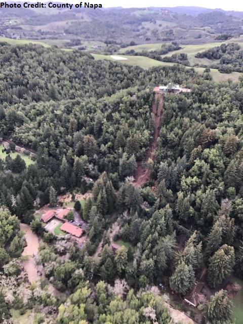
A landslide at Redwood Road, Napa County, California. Image by the County of Napa.
.
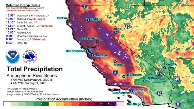
The distribution appears to be related to upland areas with active deformation from faulting. Interestingly, The Colombia Climate School has an excellent article about this rainfall event, which includes this NOAA map of the rainfall distribution up to 11 January 2023. It is instructive to compare the two maps:-

NOAA map of the distribution of precipitation in California from 26 December 2022 to 11 January 2023.
.
Meanwhile, AP has a really good article about the landslides being triggered by this seemingly unrelenting series of storms. It highlights the complex nature of landslide hazard in California, including the young geology, the impacts of prolonged drought and of course these remarkable rainfall events. As always we should remember that hazards can be natural, but disasters are human.
Inevitably, some good videos have emerged. This one occurred last week in Fresno County:-
A California Highway Patrol officer captured incredible footage of a huge landslide in Fresno County Monday afternoon. #CAwx #AtmosphericRiver https://t.co/Wqcngxk5Ea pic.twitter.com/h0bNiB8Qo3
— AccuWeather (@accuweather) January 10, 2023
.
Whilst this one occurred near Pescadero:-
Wild video of a slide continuing at partial road collapse near Pescadero.
This is at 4100 block of Stage Road.
(Vid from @CALFIRECZU)pic.twitter.com/pi7HgbZNXp— Ian Cull (@NBCian) January 14, 2023
.
Particularly interesting landslides include this one, on the Big Sur Coast:-
Big Sur Coast: Crews continue to respond at numerous locations on #Hwy1 which are showing significant instability as a result of ongoing rain event. New slide covering roadway appeared last night just south of Mill Creek. Crews are being mobilized in advance of clearing weather. pic.twitter.com/5UeuFDchov
— Caltrans District 5 (@CaltransD5) January 15, 2023
.
And, saving the best to last, this landslide occurred to the northwest of Santa Clarita:-
Castaic: on northbound I-5 the two right lanes are closed from 3 miles south of Templin Highway to Templin Highway due to a large slope slide. Unknown duration. Contractor is on scene maintaining closure. Updates at https://t.co/O37QesJHpw. Please #BeWorkZoneAlert. pic.twitter.com/HJT7U8qFSF
— Caltrans District 7 (@CaltransDist7) January 14, 2023


 Dave Petley is the Vice-Chancellor of the University of Hull in the United Kingdom. His blog provides commentary and analysis of landslide events occurring worldwide, including the landslides themselves, latest research, and conferences and meetings.
Hi Dave, the image of the Redwood Road, Napa County slide is from 2017. The linked CGS web map has not yet reported new Winter 2022/23 landslides. Have you seen a web map or dataset that does?
Great article on cbc.ca/news yesterday about th goings on in California:
cbc.ca/news/world/california-floods-mudslides-montecito-tragedy-lessons-1.6715264
Thanks for this fine article.
A question: What is the prognosis for continuing slides on California highways, especially those going through and over the burned areas in the Central Sierra, for the next 9-11 months?
That is, are those highways to be driven with caution for this year? Is there some site in the central Sierra region that may have strong data about that?
Thanks, Don Scott, Carson City