
26 January 2023
The 19 July 2019 Yahuokou landslide in Gansu Province, China
Posted by Dave Petley
The 19 July 2019 Yahuokou landslide in Gansu Province, China
On 19 July 2019, a large (3.92 million cubic metre) landslide started to develop at Dongshan Town, Zhouqu County, Gansu Province, China. This mass movement, known as the Yahuokou landslide, is described in a good paper (He et al. 2019) that has recently been published in the journal Landslides.
The failure is large – 1,920 m long over a vertical range of 550 m. The location is 33.742, 104.516 (the position given in the paper itself is unfortunately not quite correct). Rather elegantly, there is Google Earth imagery of the site captured on 31 July 2019, just a few days after the landslide occurred:-
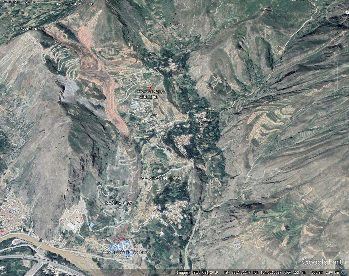
Google Earth imagery of the 19 July 2019 Yahuokou landslide in Gansu Province, China.
.
He et al. (2019) describe the impact of the landslide, noting that it destroyed roads and chicken farms; it blocked the river, causing the water level to rise; and it disrupted traffic. Movement continued for about a month.
As the image above shows, the landslide was a reactivation of an ancient landslide. The main mechanism of movement is a flow, triggered by heavy rainfall. The rate of movement was comparatively low, with failure being initiated at the crown of the slope. Movement then propagated downslope through the landslide mass.
The Google Earth imagery captures rather well the displacement of the slope, and the propagation of the landslide, given that the imagery was captured whilst movement was still developing. This image is from 31 July 2019:-
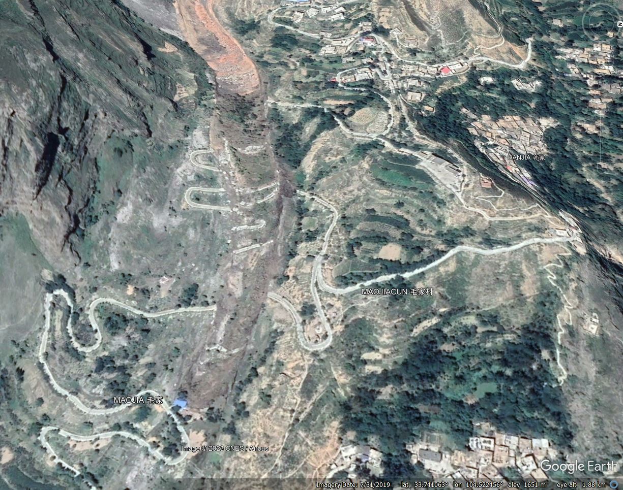
Google Earth imagery of the mid section of the 19 July 2019 Yahuokou landslide in Gansu Province, China.
.
The road provides a rather good indicator of the amount of deformation. The first (uppermost) road section has moved about 85 m. The middle section has moved about 57 metres, whilst the lower part has moved 45 metres. At the time that the image was captured the toe of the active landslide had reached the building with the blue roof, the adjacent section of road was undamaged at this point. The most recent image (from 2021) shows that the landslide subsequently propagated through this area.
He et al. (2019) have highlighted a really interesting landslide, and the availability of Google Earth imagery captured during and after the movement provides a really unusual opportunity to examine the development of a flow type failure.
.
Reference
He, Q., Guo, F., Li, R. et al. 2023. Characteristics, mobility and dynamic of the Yahuokou flow-like landslide in Zhouqu, Gansu, China. Landslides (2023). https://doi.org/10.1007/s10346-022-02000-8
 Dave Petley is the Vice-Chancellor of the University of Hull in the United Kingdom. His blog provides commentary and analysis of landslide events occurring worldwide, including the landslides themselves, latest research, and conferences and meetings.