
23 January 2023
An update on the landslide crisis at Joshimath
Posted by Dave Petley
An update on the landslide crisis at Joshimath
In India, the landslide crisis at Joshimath continues to develop. As I have noted previously, the lack of clarity in terms of the situation from the authorities is remarkable. Crisis communication is hard, but there is ample evidence that a vacuum of information will be filled by misinformation. This is leading to considerable speculation, such as a suggestion that the cause might be the loss of ponds that used to be located around the town.
It appears that the landslide continues to move, with 863 buildings now showing signs of distress. Of these, 181 are considered to be unsafe. The situation for the displaced people has been exacerbated by snowfall in recent days, which of course has the potential to add water into the system in due course. Meanwhile, demolition of the worst affected buildings continues, most notably the large hotels that have been severely damaged by the landslide.
Simon Gascoin of CNRS has posted a very useful update on CESBIO Multitemp blog about the use of the Alaska Satellite Facility’s web portal (Vertex) to generate deformation time series data for the Joshimath landslide. This generates a fascinating result:-
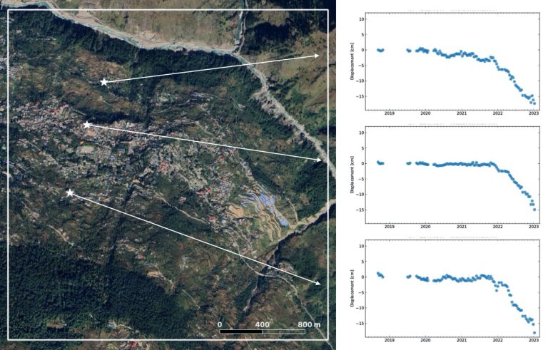
Time series of ground deformation at three locations in the Joshimath. Data generated by Simon Gascoin.
.
As Simon notes, the results support other analyses on terms of the nature and rates of movement observed. There was a sharp increase in deformation rate in October 2021, but there is a hint in the data that this might have started earlier for the point located closest to the river. This might support the suggestion that reactivation of this landslide has been triggered by erosion of the toe, but without a more detailed investigation this is conjecture.
Meanwhile, there remains a strange lack of clarity about the nature of the processes at Joshimath. Some quarters continue to report this as subsidence, which is quite misleading as it implies vertical movement. There is no real doubt that this is a landslide, with the mass slipping down the slope. At times it is good to go back to basics – Google Earth imagery clearly demonstrates that the town is built on an ancient landslide:-
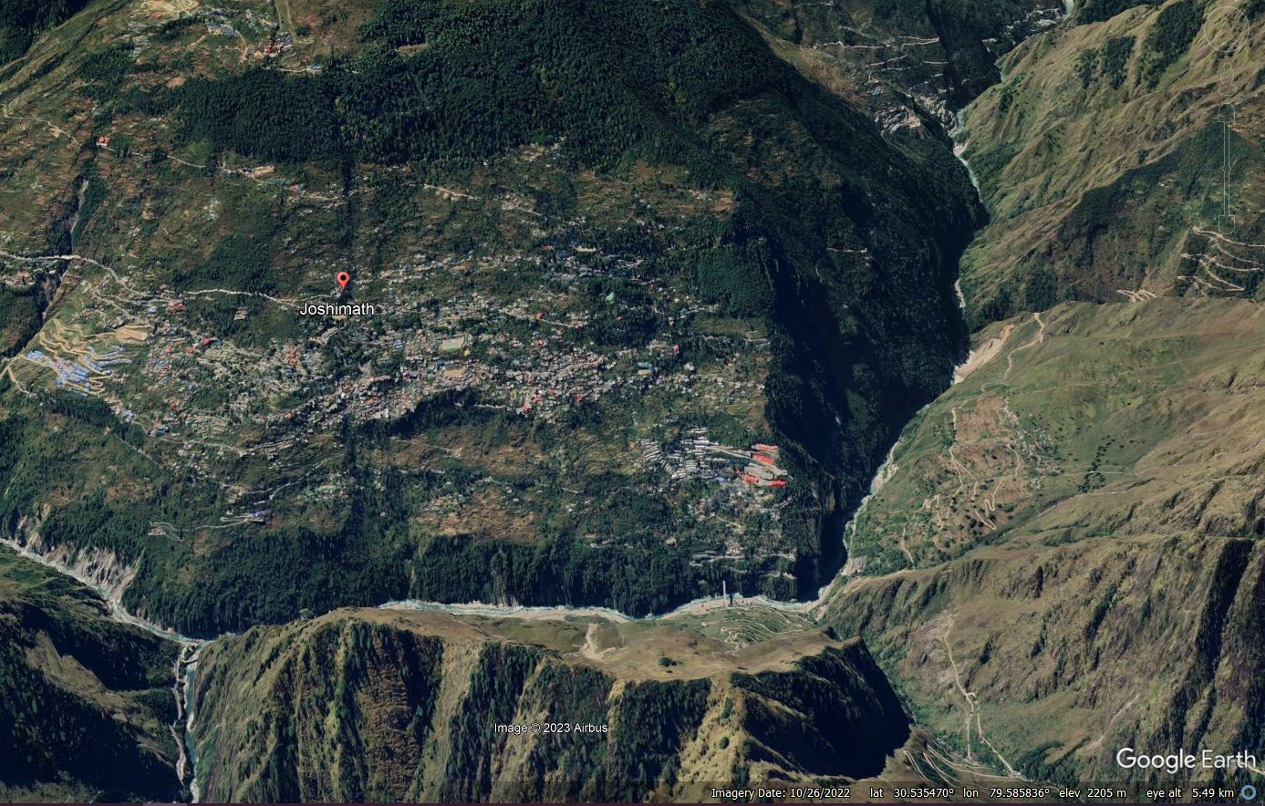
Google Earth imagery of the Joshimath landslide.
 Dave Petley is the Vice-Chancellor of the University of Hull in the United Kingdom. His blog provides commentary and analysis of landslide events occurring worldwide, including the landslides themselves, latest research, and conferences and meetings.
The joshimath phenomenon is the upper surface of ground sliding down slope leading to development of cracks
Many results are trying to equate the development of cracks in buildings with insar measurements which may not give true picture
Neither the movement is in z direction to estimate subsidence
Joshimath is sinking is a misnomer. In real terms township is located on an old stabilized moraine landslide debris which attained maturity with time. However with development and destruction of natural water channels, cutting of slopes to make way for wide roads toe erosion of this old mass due to river s , disturbing the old mass of uncondolidsted heterogenous material due to human activities at all levels net result being the sliding of this old mass along with removal of bonding material between heterogenous mass . So a lesson to be learnt – alignment of roads construction of houses all need proper geological studies if we do not want this revisit of so callled natural tragedy.