
2 October 2017
Karnali Highway in Nepal: the danger of collecting landslide videos (viewer beware)
Karnali Highway in Nepal: the danger of collecting landslide videos (viewer beware)
The Karnali Highway is the road between Surkhet and Jumla in the Nepal Himalayas. It is a long highway – 232 km in total – through a high mountain area. Despite being a fundamentally important strategic link within the Mid-Western Development area, it is a road with many problems. Wikipedia describes it as follows:-
According to “A Value Chain Analysis of Apple from Jumla”, and the intervention strategy indicates that more than 85 percent of the Karnali highway is still unsafe as of July 2011. Many rural inhabitants along the highway have poor access to markets, healthcare facilities and schools and deal with high transport costs. Inadequate roads make it hard for farmers to transport and market their crops. There is a pressing need to provide a functional road system in the area, made more urgent by current concerns over food prices and shortages, high energy costs and social and health needs Between 60 and 75 percent of children under five are chronically malnourished, and up to 64 percent of the population live in poverty.
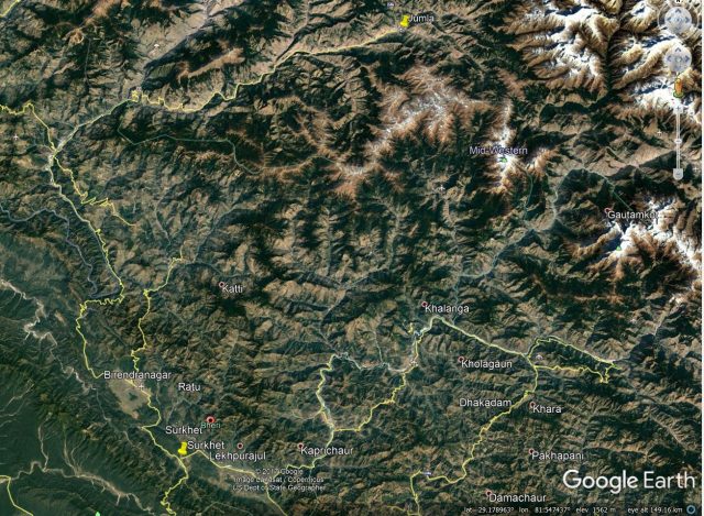
Google Earth image showing the route of the Karnali Highway in Nepal between Surkhet and Jumla
The road is commonly described as being the most dangerous highway in Nepal (and there are many dangerous roads in Nepal). However, it should not be forgotten that it has opened up a huge area of Nepal, improving access to education, healthcare and markets for many people. But road users are subject to substantial levels of hazard, and landslides are common, especially in the monsoon.
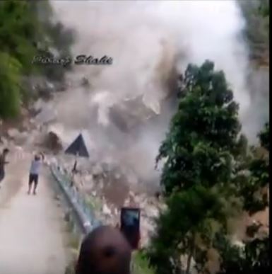
A video was posted to Youtube last week that illustrates this in a terrifying manner. The video is hard to watch as a man ends up being hit by a piece of flying rock. I urge discretion in viewing it.
.
The location of this landslide along the road is not entirely clear – the text that accompanies it describes it as follows:-
Recently the Landslide at Dahi Kohla and now at radhauney or Kagney Khola killed a bike riders and blocked for a weeks because of massive and big stones on roads.
The Jumla Nepal blog has a report about this event as well – it describes the landslide as occurring at Bagauney, although again this location is not clear to me. It is also unclear as to whether the person who was hit by the rock was killed – I cannot find any report in the Nepal media about this event.
This is a stark illustration of the dangers of filming landslides. The rockslide rapidly transitions from a relatively small event into a very major slide, presumably because of a larger rockslope collapse upslope. The size of the blocks that are moving – fast – is notable as this still from the video shows:
Still from a Youtube video of the landslide on the Karnali Highway.
.
The impact of this block into other boulders close to the road causes it to fracture, releasing pieces of fly rock. The dangers of these substantial pieces of rock are all too clear.
I often feature landslide videos on this site, and they have given us new insights into the way that slopes fail and move. However, landslides are incredibly dangerous events, and it is never worth risking your life for the sake of a piece of footage.
29 September 2017
Rize, Turkey – an extreme rainfall event yesterday triggered landslides and flash floods
Rize, Turkey – an extreme rainfall event yesterday triggered landslides and flash floods
The Rize area of Turkey yesterday suffered an extreme rainfall event. At the moment details are quite sketchy – the Watchers reports that:
At least one person has died after heavy rain caused major flash floods and landslides in the Rize region of northeastern Turkey, on September 28, 2017.
The person who died was identified in reports as a 40-year-old, Songul Tolan. The incident is reported to have happened in the village of Gurpınar, near Cayeli.
Weather stations in the region recorded 150 mm (5.9 inches) of rain within 6 hours.
There are some very dramatic videos online showing the effects, most notably the large landslide captured in this recording:-
.
This appears to be a large, rapid, potentially damaging landslide, but I can find no further details as yet. I have tried to improve a still from the video:
A still from the Youtube video showing the large landslide in Rize, Turkey
.
NASA 24 hour Global Precipitation Measurement data shows a rain cell sitting over the Rize area of Turkey, and a much larger one (with indicative maximum rainfall levels of over 229 mm in places) to the east in Azerbaijan:
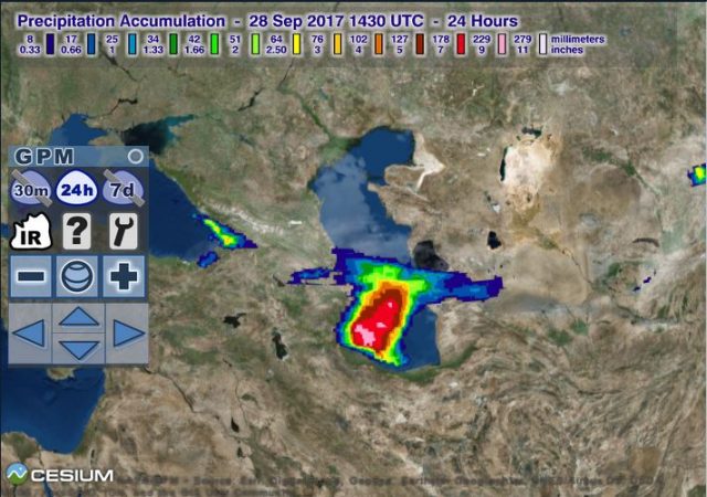
NASA GMP data showing a large rainfall event over eastern Turkey.
.
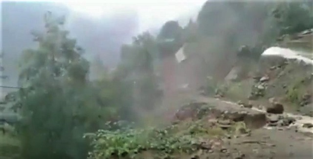
Interestingly, there also reports of landslides in Georgia yesterday, close to the western coast of the Black Sea. The rainfall event that I presume was responsible for this is also visible in the GMP image.
Turkey is of course no stranger to highly destructive landslides, and there are several publications, such as this one, that highlight the risks. In my paper on human losses from landslides (Petley 2010) I noted that Turkey suffered 22 fatal landslides between 2004 and 2010, with 85 resultant fatalities (see my blog post about this work). In the period since there have been many more landslides associated with heavy rainfall.
Reference
Petley, D.N. 2012. Global patterns of loss of life from landslides. Geology 40 (10), 927-930.
27 September 2017
Heifangtai terrace: spectacular loess flowslides in Gansu Province, China
Heifangtai terrace: a location of spectacular loess flowslides
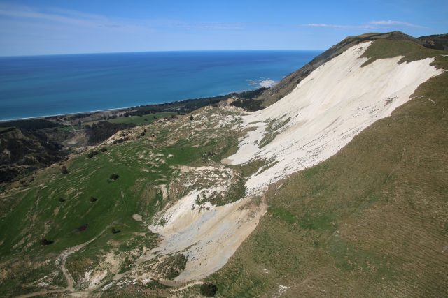
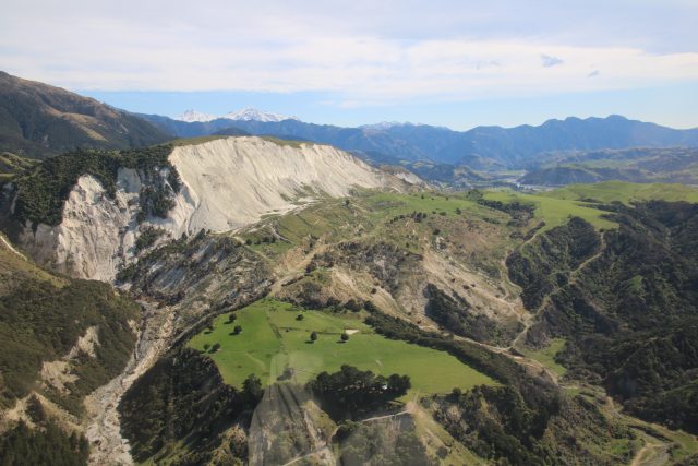
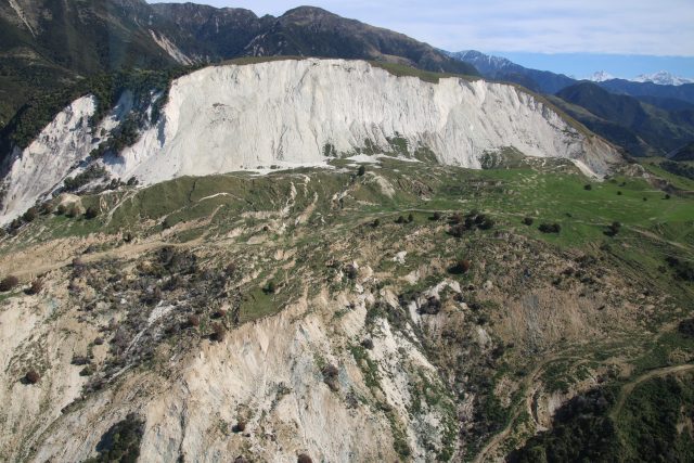
Loess, a windblown silt deposit, mantles about 6% of the land area of China. As I have noted previously, these thick loess deposits generate some of the most spectacular landslides on earth because of their potential to undergo fluidisation, allowing landslides to transition into highly destructive, long runout flowslides. In a recent paper published in the journal Engineering Geology, Qi et al. (2017) describe loess landslides on the Heifangtai terrace, which is located at the confluence of the Yellow River and the Huangshi River in Gansu Province, northwestern China. This terrace, which is located at 36.0916, 103.3089 if you want to take a look, has a cap of about 26-48 metres of loess. It is both populated (primarily by people relocated from the site of a hydroelectric plant) and irrigated. Qi et al. (2017) describe 17 loess landslides on the margins of the terrace – you can see many of these in the Google Earth image below:-
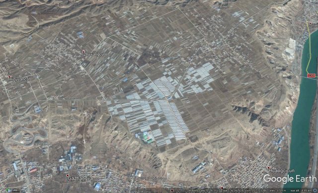
Google Earth image of the Heifangtai Terrace in Gansu, China
.
Qi et al. (2017) highlight in particular a pair of landslides that have developed in the Moshi Gully on the flanks of the terrace between 2004 and 2013. This image shows the site of these two landslides, on the southern edge of the terrace, in December 2004:-
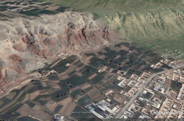
Google Earth image of the site of the landslides on the edge of the Heifangtai Terrace in 2004
.
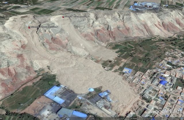
By November 2012 notable instability had started to develop at two sites on the terrace edge. I have marked the headscarps of the two landslides. At this stage the landslides appear to have low levels of mobility:-
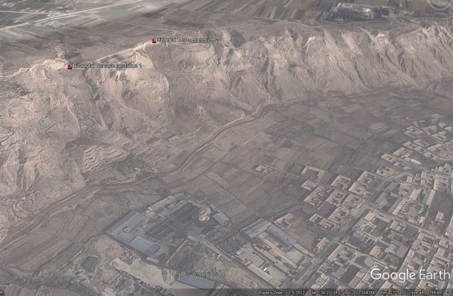
Google Earth image from November 2012 showing the two landslides on the Heifangtai Terrace.
.
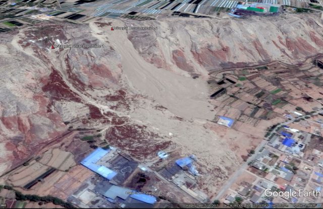
By February 2015 one of the two landslides, the one further from the camera, had developed significantly. As Qi et al. (2017) note, this slide had shows retrogression of the headscarp and had started to develop a clear flow-type structure. Note though that the mobility is still low:-
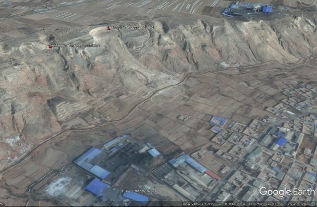
Google Earth image from February 2015 showing the two landslides on the Heifangtai Terrace.
.
But by September 2015 the landslides have changed dramatically:-
Google Earth image from September 2015 showing the landslides on the Heifangtai Terrace.
.
Both slides have failed spectacularly, with the one in the foreground in particular showing very high mobility and extreme retrogression. Qi et al. (2017) report that this landslide occurred in a two stage process in April 2015. The first failure, involving 80,000 m3, occurred on 29th April 2015 at 7:50 am. The second happened about three hours later in three distinct phases. The landslide travelled almost 800 metres.
The most recent image, from May 2017, shows that this landslide has undergone little change, but the other has suffered a further failure event:-
Google Earth image from May 2017 showing further landslide activity on the Heifangtei Terrace
.
Worryingly, landslide activity is clearly developing on other sections of the terrace edge.
Reference
Xing Qi, Qiang Xu and Fangzhou Liu 2017 Analysis of retrogressive loess flowslides in Heifangtai, China. Engineering Geology.
26 September 2017
El Jale, Ixtapaluca: a stunning earthquake triggered landslide video from Mexico
A still from the Youtube video of the landslides at El Jale in Mexico.
.
El Jale, Ixtapaluca: a stunning earthquake triggered landslide video from Mexico
On the day of the earthquake in Mexico I noted that there was a high chance that it would have triggered landslides. It was always unlikely that this would be efficient in so doing in the manner of, for example, the Kaikoura earthquake (due to the depth of the rupture), it had the potential to generate slides over a wide area. A video has recently been posted to Youtube that shows landslides being triggered by this event, reportedly El Jale in Ixtapaluca in Mexico City. It is spectacular:
.
This is a Google Earth image of the Ixtapaluca area:-
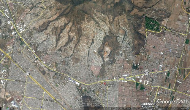
Google Earth image of the Ixtapaluca area of Mexico City
.
The video appears to show the collapse of a quarry wall in a comparatively rural area. The one quarry shown above does not seem to fit the video. A better fit to the video appears to a set of quarries located further to the east:-
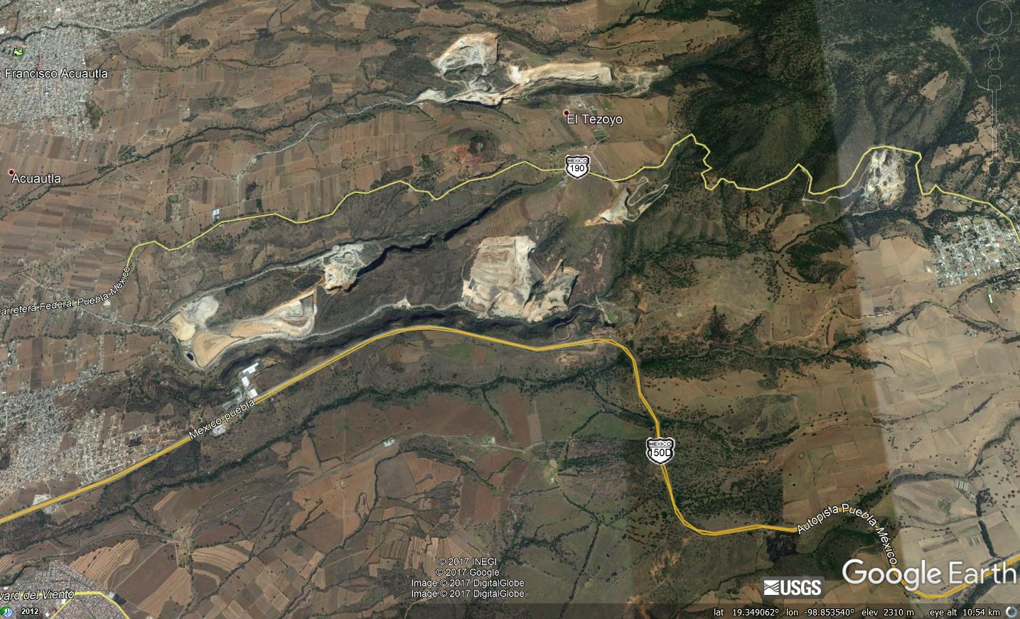
Google Earth image of the quarries near to El Jale that may have been responsible for the landslide captured on video
.
These quarries are likely to be mining volcanic materials, which would explain both the instability and the large amounts of dust generated. It is not clear as to whether there was any losses from these landslides. One early report did suggest that a quarry worker was killed in the event, but the location was given as Morales state, so it is unlikely to be this event:
Morelos Gov. Graco Ramirez reported on Twitter that at least 42 people had died in his state south of Mexico City. Gov. Alfredo del Mazo told the Televisa news network that two people died in the State of Mexico, which also borders the capital: a quarry worker who was killed when the quake unleashed a rockslide and another person who was hit by a falling lamppost.
So far this part of the area affected by the earthquake has not yet been fully images by Planet Labs. I’ll take a look when images become available.
21 September 2017
Landslides from the Kaikoura earthquake part 5 – other valley-blocking slips
Landslides from the Kaikoura earthquake part 5 – other valley-blocking slips
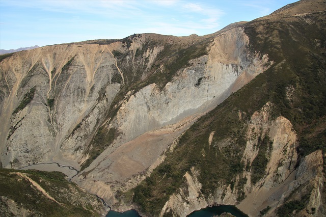
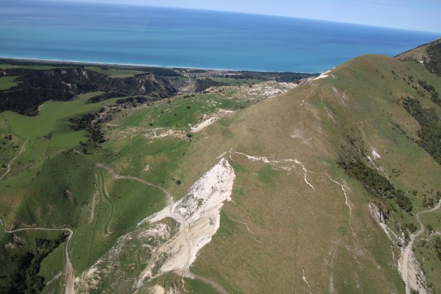
In addition to the large valley-blocking slips that I featured in my earlier posts in this series, the Kaikoura Earthquake triggered many other valley-blocking landslides. Most of these were of a medium size, and breached soon after the earthquake without causing any major issues. This is a very spectacular example:-
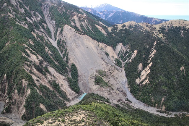
A valley-blocking slip from the Kaikoura earthquake.
.
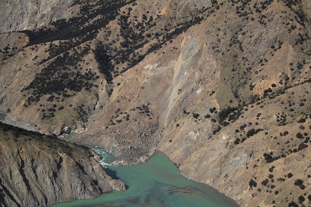
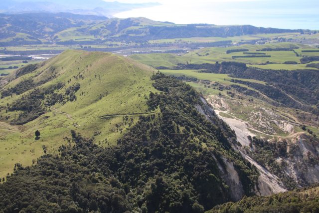
This is quite a spectacular example of a rockslide on a planar surface that has destroyed a ridge. It clearly impeded the channel on the right of the image, and blocked the main drainage line. A small lake is visible. However, from above the head scarp it is clear that the landslide dam is not causing major issues:-
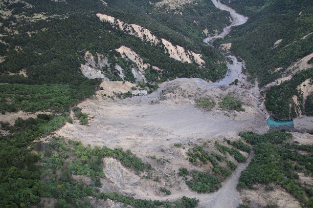
An alternative view of a large valley-blocking slip from the Kaikoura earthquake.
.
Further the south there are some reasonably large slumps that also blocked the valley:
A valley-blocking slip from the south of the area affected by the Kaikoura earthquake.
.
Again the lakes created by the blockages are very clear, but they are neither large nor particularly troubling. Of course the impact on the farmers who owned these areas of land is large though.
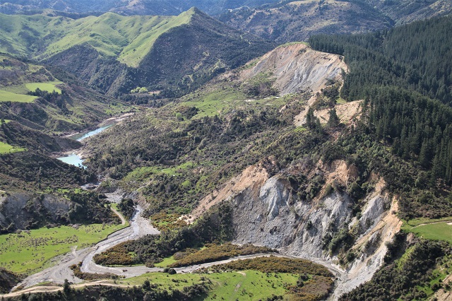
In the higher areas there are some classic rockslides that have impeded the river. This very complex example had quite a large runout:
A reasonably-significant valley-blocking rockslide. Note the secondary failure above the main slide
.
This appears to be a planar rockslide. The additional slide on the ridgeline, in a weathered material, is an interesting juxtaposition with the main slide. Given the location of the deposit, it seems likely that this happened after the main rockslide. The remains of the lake are visible. In this case there was significant incision through the fine-grained dam at the point of the breach.
Finally, some of the rockslides are actually quite simple:
A simple valley-blocking rockslide from the Kaikoura earthquake.
.
This landslide briefly blocked the Clarence River, but has now comprehensively breached.
Landslides from the Kaikoura Earthquake
The earlier posts in this series are as follows:
- Landslides from the Kaikoura earthquake part 1: the Seafront landslide
- Landslides from the Kaikoura Earthquake part 2: the Hapuku landslide
- Landslides from the Kaikoura Earthquake part 3: the Leader 220 landslide
- Landslides from the Kaikoura Earthquake Part 4: partially failed slopes
19 September 2017
Potential landslides from the M=7.1 earthquake at Raboso, Mexico on 19th September 2017
Potential landslides from the M=7.1 earthquake at Raboso, Mexico on 19th September 2017
The major earthquake that struck near to Raboso in central Mexico earlier today, 19th September 2017, has the potential to have caused substantial damage. The initial data from the USGS places the epicentre in a rural area, which will reduce (but certainly not eliminate) human losses, although the picture at the nearby town of Izucar de Matamoros could be very challenging. It is interesting to note that the USGS has recorded very few felt reports from this area, which may suggest that communications are compromised. As usual the current media focus is on the urban area (Mexico City), but this is unlikely to be where the whole story is located. A few years ago I wrote about the pitfalls often experienced by media agencies in reporting earthquakes. I think the advice still stands.
In terms of landslides, the initial USGS data suggests that the area with significant levels of intensity has some steep slopes. This is the USGS intensity data for the earthquake, plotted onto Google Earth:-
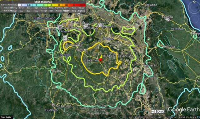
Google Earth image of the USGS intensity data for the earthquake at Raboso, Mexico
.
This map shows the area affected by Intensity of VI and greater:-
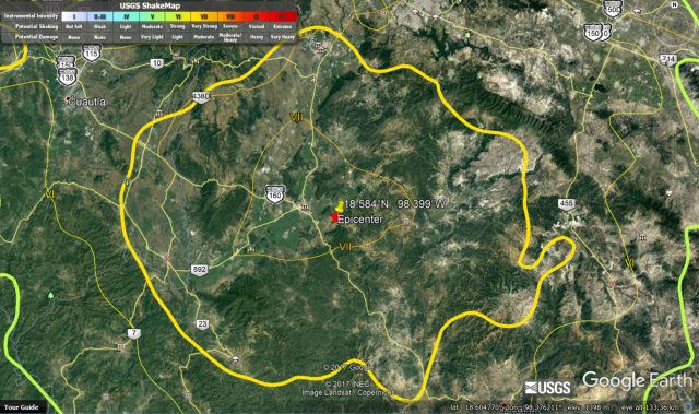
Google Earth image of the area with intensity of VI and greater, based on USGS data, for the earthquake at Raboso in Mexico.
.
Based upon this there is enough terrain to generate a significant number of landslides, although the relatively low relief suggests that these are likely to be mostly small and comparatively shallow. Further afield there is more significant terrain; it will be interesting to see if the shaking has been sufficiently large to generate landslides here. The depth of the earthquake suggests that the shaking will be generally strong but not extreme, but will have affected a broad area, giving landslide potential over a wide area.
Previous crustal earthquakes in Mexico have generated landslides. A few years ago we studied the landslide distribution from the 2010 M=7.2 Sierra Cucapah earthquake in northern Mexico (written up in Barlow et al. 2014). This was the event that generated the impressive youtube video of dust generation in the mountains. We mapped 452 landslides, which is not insignificant, but lower than normally expected, probably because of the arid conditions in northern Mexico. The area affected by the earthquake today is much less arid.
It will be much easier to understand the likely landslide distribution once we understand the fault that ruptured.
Reference
Barlow, J., Barisin, I., Rosser, N., Petley, D., Densmore, A. and Wright, T. 2014. Seismically-induced mass movements and volumetric fluxes resulting from the 2010 Mw = 7.2 earthquake in the Sierra Cucapah, Mexico, Geomorphology, Available online 24 November 2014, http://dx.doi.org/10.1016/j.geomorph.2014.11.012.
18 September 2017
Landslides from the Kaikoura Earthquake Part 4: partially failed slopes
Landslides from the Kaikoura Earthquake Part 4: partially failed slopes
A characteristic of every large landslide-inducing large earthquake that I have studied is the large number of partially failed slopes. These are slopes that have started to fail during the earthquake, but have not completely collapsed. Typically, in an earthquake-affected mountain chain we see numerous examples of this phenomenon. The Kaikoura Earthquake was no exception. I present here a number of examples. Sometimes these partially failed slopes are very obvious incipient landslides – this one for example is very clear:-
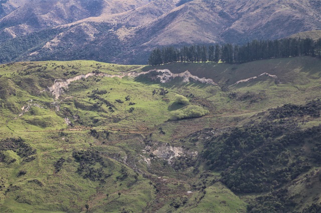
An example of a partially failed slope from the Kaikoura earthquake.
.
In other cases the features are much more subtle. This is an example of a highly deformed slope that has the complex morphology of several arcuate tension cracks and lateral scarps, but it is clear that the amount of strain (movement) is quite limited to date:-
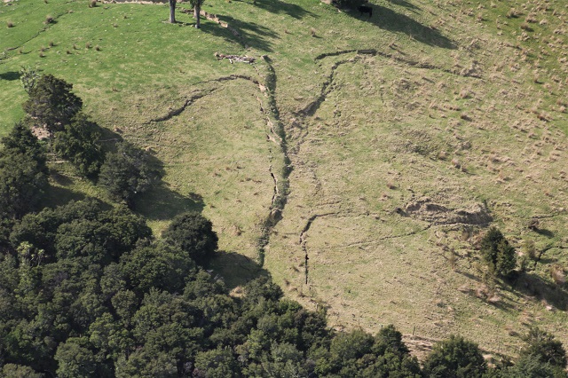
The complex arcuate scarps of a partially failed slope from the Kaikoura earthquake.
.
In other cases the slope processes leave an incredibly complex pattern of extension and deformation, to the extent that it takes a while to work out what is happening in the landscape:-
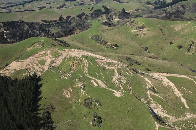
A very complex partially failed slope generated by the Kaikoura earthquake.
.
And sometimes we are left with multiple arrays of parallel tension cracks. This was a very common pattern in 2005 Kashmir Earthquake in Pakistan. We saw the same pattern, but to a lesser degree, in the Kaikoura Earthquake in some locations:-
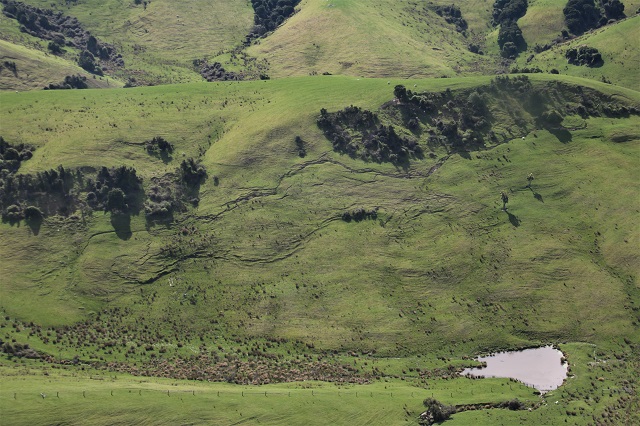
A partially failed slope from the Kaikoura earthquake.
.
Anticipating how these slopes may behave is very challenging at the scale of any individual slope and across the whole landscape. Clearly the nature of the long term hazard will be very dependent on this effect. Interestingly, in many other earthquakes the majority of such partially failed slopes have not failed (although in every case some slopes have collapsed, which preclused making assumptions about future behaviour). The exception may be the 2008 Wenchuan Earthquake, where these secondary failures remain a very major problem nine years on.
It will be fascinating to observe what happens in the aftermath of this event.
.
Landslides from the Kaikoura Earthquake
The earlier posts in this series are as follows:
- Landslides from the Kaikoura earthquake part 1: the Seafront landslide
- Landslides from the Kaikoura Earthquake part 2: the Hapuku landslide
- Landslides from the Kaikoura Earthquake part 3: the Leader 220 landslide
17 September 2017
Landslides from the Kaikoura Earthquake part 3: the Leader 220 landslide
Landslides from the Kaikoura Earthquake part 3: the Leader 220 landslide
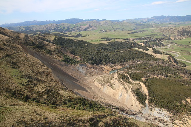
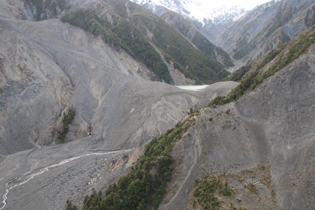
The Leader 220 landslide, located on the Leader Rover close to Woodchester (the location is -42.585, 173.215 if you want to take a look on Google Earth), is another large valley blocking landslide triggered by the Kaikoura Earthquake in New Zealand. This is one of the most spectacular and photogenic of all of the landslides:
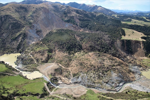
The Leader 220 landslide triggered by the Kaikoura earthquake
.
This is a large slump with a near planar, steep back scarp. The landslide has moved as a single block, but has extensively deformed as it transitioned from the steep back scarp to the near horizontal valley floor. The landslide has pushed the river across the valley floor such that it is now flowing over old terrace surfaces:
The aftermath of the Leader 220 landslide
.
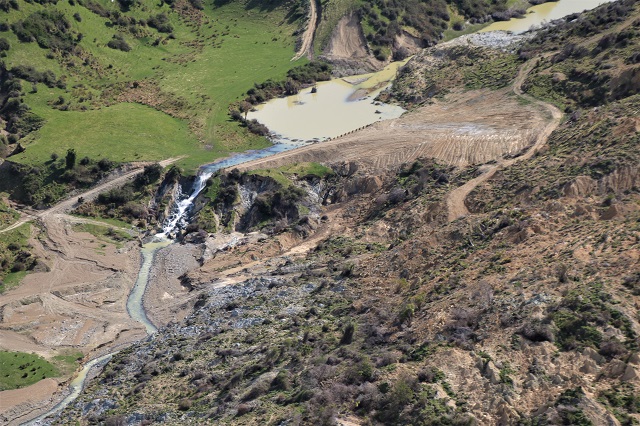
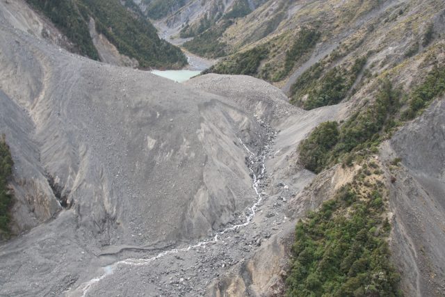
The landslide dam has now breached but the lake remains partially intact. This has caused some properties to be inundated:
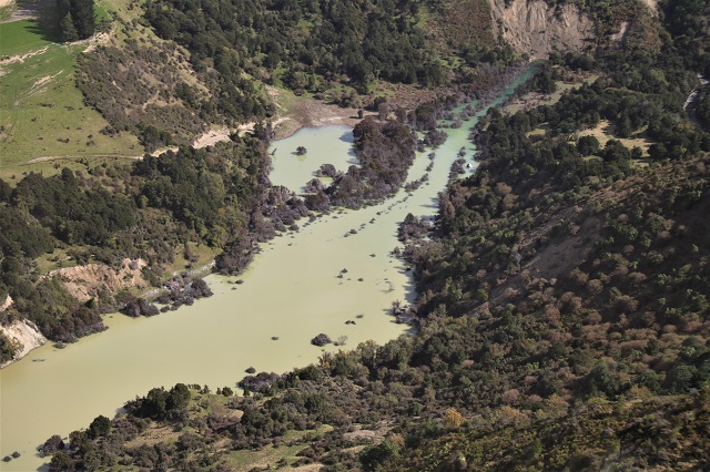
A property flooded by the Leader 220 landslide lake.
.
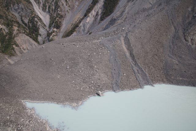
This is a slope that is undergoing considerable post-earthquake landslide activity. This image shows the foot of the main scarp, and the multiple flow type failures that have occurred:
Post seismic flows that have occurred at the site of the Leader 220 landslide, triggered by the Kaikoura Earthquake.
.
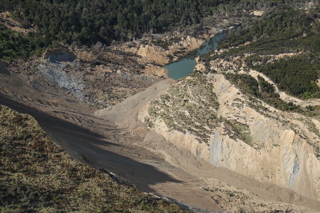
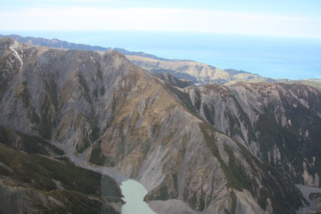
The image above also shows some interesting deformation occurring at the trailing edge of the displaced block – in effect this is a landslide within a landslide as the edge of the block slumps back into the scarp depression. The image below shows this from a wider perspective – it is not an insubstantial landslide in its own right:
An overview from the scarp of the Leader 220 landslide, showing deformation in the displaced block.
.
Monitoring how this deformed mass behaves in the next few years will be fascinating. It appears that considerable post-seismic landscape evolution will occur before conditions each a new equilibrium. GNS Science have a newly funded MBIE Endeavour project for the next few years to monitor the evolution of the landscape after the earthquake.
Landslides from the Kaikoura Earthquake
The earlier posts in this series are as follows:
- Landslides from the Kaikoura earthquake part 1: the Seafront landslide
- Landslides from the Kaikoura Earthquake part 2: the Hapuku landslide
16 September 2017
Landslides from the Kaikoura Earthquake part 2: the Hapuku landslide
Landslides from the Kaikoura Earthquake part 2: the Hapuku landslide
The longest runout slide triggered by the Kaikoura Earthquake was the Hapuku landslide, which occurred high up in the catchmnet of the Hapuku River. This landslide is at -42.237, 173.664 if you want to take a look on Google Earth. This landslide is a long (2.7 km) rock avalanche with a volume of about 10-14 million cubic metres. The elevation change from the crown (which is at the ridge top) to the toe is about 1,900 metres. To get a full appreciation of this landslide the Google Earth imagery is helpful:-
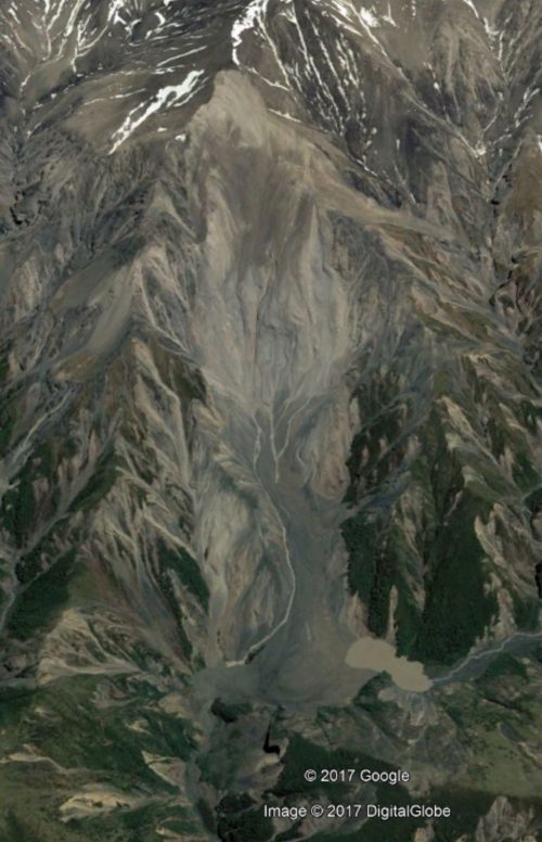
Google Earth image of the Hapuku landslide, triggered by the Kaikoura earthquake
.
As the image shows, the landslide crown is at the ridge line (which is common for earthquake triggered landslides), whilst the debris at the toe has blocked the valley.
This is a helicopter image of the upper portion of the landslide:
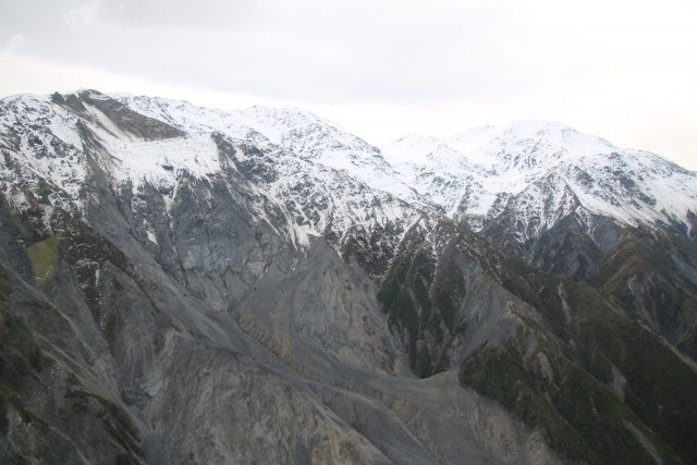
The upper portion of the Hapuku landslide
.
This suggests that the failure event in the upper portion of the landslide was complex, and that there is still some debris on the slope. The image below shows the track of the landslide to the toe:-
The track of the Hapuku landslide.
.
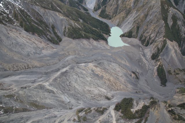
Note the small remaining lake caused by the blockage of the channel (the breach is also visible). The landslide has left a large amount of bare rock. This image shows the landslide debris:-
The deposit of the Hapuku landslide
.
The landslide dam has breached – this image shows the breach channel clearly:
The breach channel from the Hapuku landslide dam
As with many other locations, this landslide has seen some secondary failures in periods of heavy rainfall since the Kaikoura earthquake:
Tracks from secondary failures at the Hapuku landslide
.
As with the Seaward landslide, one of the fault ruptures runs through the scar of the this landslide. It is therefore unsurprising that there are many other landslides triggered by the Kaikoura earthquake in this area:
Other landslides triggered by the Kaikoura earthquake in the catchment of the Hapuku River
14 September 2017
Landslides from the Kaikoura earthquake part 1: the Seafront landslide (also wrongly known as the Seaward landslide)
Landslides from the Kaikoura earthquake part 1: the Seafront Landslide
Yesterday, I was lucky enough to be able to fly over the area affected by the Kaikoura earthquake by helicopter, together with colleagues from GNS Science. Over the next few days I will post some images of the earthquake-induced landslides that I took on this flight. I am starting with the very large and very complex Seafront landslide, which is perhaps the most infamous of all the landslides triggered in this earthquake, thanks to images that went viral showing three cows trapped on a displaced raft on the landslide. For this reason the slide became known as the Cow Slide, but it is correctly termed the Seafront Landslide (also known, wrongly, as the Seaward Landslide):-
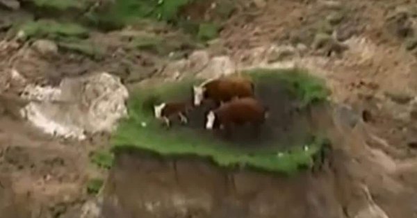
Cows trapped on the Seafront Landslide, via The Daily Telegraph
.
The cows were rescued. This is very large, very complex landslide. If you want to locate it on Google Earth it is at -42.178, 173.880. This is a view of the landslide from the north:
The Seafront Landslide, triggered by the Kaikoura earthquake, viewed from the north.
.
Whilst this is the landslide viewed from the south:
The Seafront Landslide, triggered by the Kaikoura earthquake, viewed from the south.
The images show that this is very wide, broad slump type landslide in which, quite literally, the side of the ridge has detached and slipped. At the toe the slide has broken up considerably, whilst in other sections it has remained remarkably coherent. This image shows the very complex behaviour of this displaced block. Note that some sections of the slide have been modified by the farmer to try to regain productive land:
The displaced mass of the Seafront Landslide, triggered by the Kaikoura earthquake.
.
One other really interesting observation about this landslide is that the northern edge of the ridge also failed, and that a much larger section partially displaced but did not collapse:
The failure at the northern end of the ridge from which the Seafront Landslide originated. Note the large, partially failed section.
.
Whilst the other (west) side of the ridge appears to be essentially undamaged, even though it is steep:
The west side of the ridge from which the Seafront Landslide originated. Note the lack of slope failures.
.
This illustrates perfectly why it is so hard to forecast the behaviour of slopes in earthquakes.
 Dave Petley is the Vice-Chancellor of the University of Hull in the United Kingdom. His blog provides commentary and analysis of landslide events occurring worldwide, including the landslides themselves, latest research, and conferences and meetings.
Recent Comments