20 November 2016
Geonet commentary on landslides triggered by the Kaikoura Earthquake
Posted by Dave Petley
Geonet commentary on landslides triggered by the Kaikoura Earthquake
Geonet has now posted an initial commentary on the landslides triggered by the Kaikoura earthquake in New Zealand a week ago. I won’t seek to reproduce what they have stated, but the headlines are:
- There are between 80,000 and 100,000 landslides over an area of about 7,000 square kilometres.
- Based on an initial analysis of a new Worldview-2 satellite image there are 12 valley blocking landslides (landslide dams).
Many of these are likely to have breached naturally already, but all need assessment to this end, Geonet state that:
GNS has also started systematically flying landslide affected areas to visually identify landslide dammed lakes. The southeast flank of the Seaward Kaikouras, was flown on the 16th November and seven landslide dams were found. These flights will continue over the next three or four days. The purpose of these flights is to systematically cover affected areas where no data is currently available. The second purpose is to photograph the landslide dams to allow assessment of the hazard at each site.
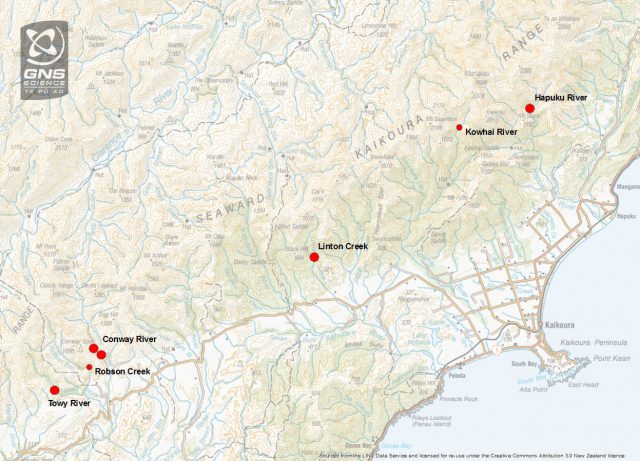
The have provided a map of some of these landslide dams:

Geonet map of some of the landslide dams following the Kaikoura Earthquake.
.
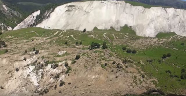
Meanwhile, Environment Canterbury is now posting a series of videos showing aspects of the damage caused by the earthquake. The Youtube channel can be found here. Some of the landslides are impressive. I particularly recommend the Waipapa Landslide video:
.
This is a very deep seated slump on an unusually large scale:

The unusually large large slump at Waipapa, via Environment Canterbury
.
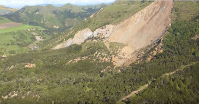
There is also a nice video of a large, complex and quite long runout landslide on the Leader River:
.
Again, this appears to be a deep-seated slump. Interestingly, in both cases the landslides have a very planar rear scarp:

A deep-seated slump on the Leader River, via Environment Canterbury
.
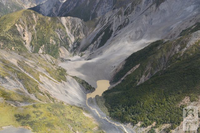
But the finest image is in the Geonet report that I cited above. This is an image of the valley blocking landslide on the Hapaku River:

The Hapaku River landslide, via Geonet
.
As well as the very large scale of this valley blocking landslide, this image shows the vast number of additional landslides triggered by the earthquake. Experience from elsewhere suggests that this number will increase in the first very heavy rainfall event after the earthquake.


 Dave Petley is the Vice-Chancellor of the University of Hull in the United Kingdom. His blog provides commentary and analysis of landslide events occurring worldwide, including the landslides themselves, latest research, and conferences and meetings.