

12 September 2017
Increasing rock avalanche size and mobility in Alaska may be associated with climate change
Increasing rock-avalanche size and mobility in Alaska
One of the most interesting landslide issues in recent years has been the cluster of rock avalanches that have occurred in the Glacier Bay National Park and Preserve in the southern part of Alaska (example include Lamplugh Glacier, Tyndall Glacier, Ferebee Glacier and Mount La Perouse). This area appears to have been affected by far more very large events than anywhere else over the last 20 years or so; the reasons for this have not been clear. In a new open access paper just published in the journal Landslides, Coe et al. (2017) have used Landsat imagery to map these events in the period between 1984 and 2016. Over this period this area experienced 24 rock avalanche events in a 5000 km² area, ranging from 5.5 km² to 22.2 km² in area. This map, from the paper, shows the distribution of these 24 rock avalanches:-
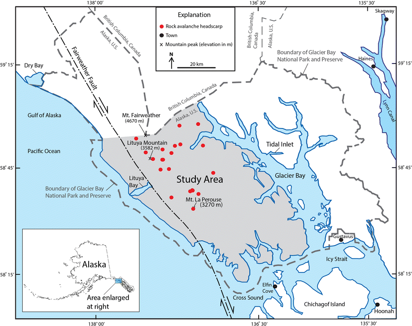
The distribution of rock avalanches in the Glacier Bay study area, from Coe et al. (2017)
.
Some of these rock avalanches have been spectacular. This for example is a Planet Labs image of the July 2016 Lamplugh Glacier rock avalanche:-
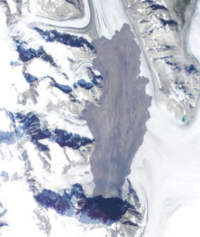
Planet Labs image of the Lamplugh Glacier rock avalanche of July 2016, in Alaska.
.
From their mapping, Coe et al. (2017) concluded that all of the rock avalanches initiated from high mountain ridges or peaks. All occurred in the northern part of the study area, and most had an aspect towards the north, generally towards the northwest. Clusters in rock avalanche behaviour occurred in the periods 1984 to 1986; 1994 to 1995; and 2012 to the present. Notably, the most recent cluster has involved larger, more mobile rock avalanches than had been seen previously, and these landslides have tended to originate from higher elevations, with higher levels of mobility.
Coe et al. (2017) consider carefully why these changes may be occurring. They state that:
We hypothesize that degradation of rock permafrost is the primary factor that controlled the timing and size of rock avalanches in the Glacier Bay region.
This part of Alaska shows a clear warming trend over the last few decades. Coe et al. (2017) provide an analysis of the climate data that strongly supports the idea that the increasing temperatures may be leading to a degradation of previously permanently frozen rock masses in the high peak areas.
This is the most convincing evidence that I have seen to date that increasing temperatures are driving a higher rate of rock slope failure in high mountains, a trend that we also seem to be seeing in for example the Alps in Europe and the Southern Alps in New Zealand. It suggests that there is a pressing need for increased research into the processes occurring in high mountain slopes, including in situ monitoring. The implications are clear though – as climate change continues to drive warming in high mountain areas the risks associated with rock slope failure will increase.
Reference
Coe, J.A., Bessette-Kirton, E.K. & Geertsema, M. 2017. Increasing rock-avalanche size and mobility in Glacier Bay National Park and Preserve, Alaska detected from 1984 to 2016 Landsat imagery. Landslides https://doi.org/10.1007/s10346-017-0879-7
Acknowledgement
Planet Team (2017). Planet Application Program Interface: In Space for Life on Earth. San Francisco, CA. https://api.planet.com
11 September 2017
A dramatic earthflow video from Dimye village in Tibet
A dramatic earthflow video from Dimye village in Tibet
A video has been circulating this weekend on Twitter showing a dramatic earthflow from Dimye in Tibet. This apparently originated from Wechat & Weibo in China, although very little information is available about it. This is the Youtube version:-
.
The accompanying text for the video associated it with melting permafrost. On Twitter, Mika McKinnon (@mikamckinnnon) has undertaken a huge amount of background work on this event, and has identified the location as Dimye village, Zatoe (Zaduo in Chinese) township, Tridu county, Yushu prefecture, Qinghai Province. The landslide occurred on 7th September 2017. She also found an additional video of the landslide on Facebook.
Whilst the posting links this event to permafrost degradation, this is not clear to me. This image, from the second video, shows the materials involved in the landslide:-
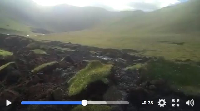
A still from a Facebook video showing the earthflow at Dimye in Tibet.
.
The video does not showing any obvious frozen soil or ice blocks. To me this is quite reminiscent of the landslides that we see in peat in the uplands of Europe. My fellow blogger Callan Bentley featured a nice example on his blog exactly a year ago. The soils involved in the Dimye village landslide are extremely dark in colour, which suggests that they are rich in organic matter. I note that in a recent (open access) paper, Yang et al. (2017) describe peat areas in the Qinghai-Tibetan area, noting that there is significant environmental degradation occurring in these places, causing rapid peat loss.
It is not possible to say whether this is indeed a peat landslide, or something similar in an organic soil, or a permafrost slide. Unfortunately, I doubt that more information will become available in the near future. But it is a great video.
Reference
, , , , , , , , , , , , , and . 2017. Qinghai–Tibetan Plateau peatland sustainable utilization under anthropogenic disturbances and climate change. Ecosystem Health and Sustainability 3 (3):e01263. doi: 10.1002/ehs2.1263
6 September 2017
Landslides from the North Korea nuclear weapon test
Landslides from the North Korea nuclear weapon test
There are various news reports today that the North Korea nuclear weapon test on Sunday triggered landslides in the local terrain. This is based on an initial analysis of Planet Labs imagery by three analysts from 38 North, which is dedicated to analysis of events in North Korea. Their report says:
Commercial satellite imagery from Planet, obtained the day after North Korea conducted its largest test to date (currently estimated in the 100+ kiloton range), appears to show numerous landslides throughout the Punggye-ri Nuclear Test Site and beyond
And they have produced this image:-
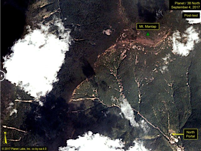
38 North and Planet Labs imagery of the site of the North Korea nuclear weapons test. Image collected after the test showing landslides triggered by the underground blast.
.
This appears to be interpreted in some quarters to indicate that the weapon was particularly large. For example, Newser has the headline:
This is a Planet Labs image from 6th September (i.e. today) showing the area of Mount Mantap affected by the underground nuclear weapons test:-
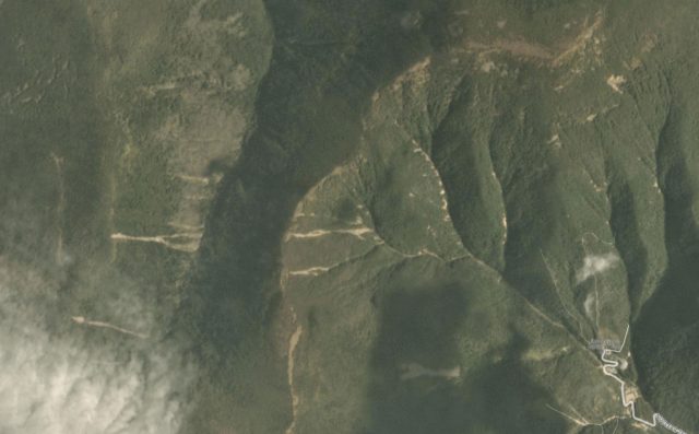
Planet Labs image of 6th September 2017 showing the area affected by the North Korea nuclear weapon test
.
This is the same area on a Planet Labs image dated 26th August, definitely collected before the most recent weapons test:
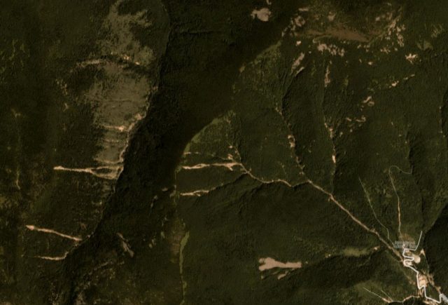
Planet Labs image of the area affected by the North Korea nuclear weapon test. Image collected on 26th August 2017, prior to the test
There are undoubtedly some new landslides in the post-test image, although most of the larger ones in the imagery were pre-existing. The new landslides appear to be mostly small, and they are focused close to the channel, perhaps where there is either accumulated debris or steeper slopes due to incision. There are a few larger events in the gully systems. It is not the case, as far as I can see, that there is very extensive landsliding in the area affected by the nuclear weapons test – certainly not on the scale that we see from major earthquakes in mountainous areas.
That underground nuclear weapons tests trigger landslides in local mountain areas is not new, and nor is it surprising. The explosion induces ground shaking that is similar in some ways to an earthquake, although the nature of the shaking itself is quite different. In fact, the North Korean landslides are very localised and small compared with some other examples. In a book chapter that is partly online, the Russian landslide scientist V.V. Adushkin describes rock avalanches triggered by eight different underground nuclear weapons tests at the Soviet Novaya Zemlia test site during the subterranean weapon testing programme there. Two of these were enormous – the largest had a volume of 80 million m³, whilst another had a volume of 5 million m³. This is clearly very much larger than the landslides in North Korea.
Thus, although the landslides triggered by this test are interesting, they are neither surprising nor exceptional. If North Korea develops larger weapons then we are likely to see bigger landslides, although this is the least of our worries perhaps. As an aside, Fox News and few other agencies are reporting Chinese scientists as indicating that they have concerns about collapse of the mountain in the event of another test. If this is the case I find it surprising that there are not more landslides on the massif, but I do not know the grounds for their suggestions.
Acknowledgement
Planet Team (2017). Planet Application Program Interface: In Space for Life on Earth. San Francisco, CA. https://api.planet.com
4 September 2017
Shimla: a landslide caught on video from multiple angles
Shimla: a landslide caught on video from multiple angles
The prolonged, late monsoon heavy rainfall across South Asia is attracting some attention now, although the media coverage remains shamefully thin. The reasons for this go way beyond the remit of this blog of course, and are extensively discussed elsewhere. Meanwhile the rainfall continues, and inevitably landslides are a consequence in this environment. On Saturday afternoon a significant landslide occurred at Dhalli in Shimla, burying several vehicles but fortunately causing no loss of life. This landslide was captured on video from several angles. The explanation appears to be that precursory rockfall activity started about 20 minutes before the main failure event, allowing the road to be closed and, presumably, bystanders to start the cameras on their phones.
This shot captures the event from a distance:-
.
Whilst this one captures it from a similar angle, but with a higher level of resolution:
.
And this video captures the landslide from the side:-
.
Together these videos provide a remarkable understanding of how the failure developed and progressed. Failure appears to initiate with a buckling process at the front of the landslide, which allowed material upslope to slide. Whoever owned the white car at the toe of the slope had a lucky escape. The three properties, including the partially constructed building at the toe of the slope, could also have had a more serious outcome, although the one alongside the road was seriously damaged. This image from NDTV shows the aftermath of the landslide in Shimla:
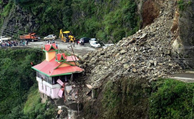
The aftermath of the landslide in Shimla. Image from NDTV.
.
This is of course not the first landslide in Shimla. An interesting aspect is this image of the slope immediately before the failure event:
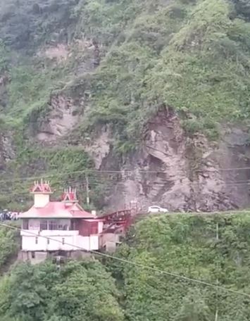
A still from a Youtube video showing the landslide at Shimla.
.
There can be little doubt that excavation of the slope has occurred at this site. As I have noted previously, poor quality road construction is a major cause of landslides across South Asia.
1 September 2017
Stunning, unbelievable, high resolution footage of the Zhangjiawan rockslide
Stunning, unbelievable, high resolution footage of the Zhangjiawan rockslide
Reader Fabien has kindly pointed out to me that Liveleak has new footage of the Zhangjiawan rockslide in Guizhou Province in China, which killed 26 people and left a further nine missing and presumed killed. This is the recording, which sadly has no further metadata. Frustratingly WordPress no longer allows me to embed Liveleak videos, so I have embedded the Youtube copy of the video:-
.
This is undoubtedly one of the best ever recordings of the development of a major rockslide, capturing the precursory rockfall activity as well as the final failure event. The impression is clearly of a progressively disintegrating rockmass, rapidly fragmenting as movement develops. This may well be associated with the development of rotation in the mass. I have captured three elements of the initiation of the final collapse below:-
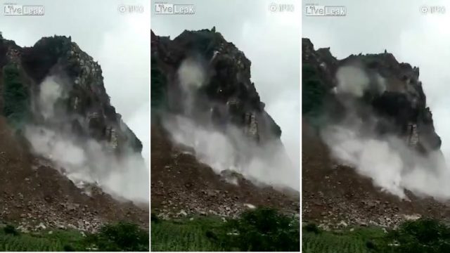
The initiation of the Zhangjiawan rockslide. Stilll from a video posted pseudo-anonymously to Liveleak
.
This sequence shows that at the point of the development of rapid motion the rockslide was undergoing both toppling (i.e. the mass was rotating such that the upper section of the rockmass was moving more rapidly than the lower portion, and the whole mass is in effect tilting forwards) and basal sliding into the valley. This is a large-scale version of the motion that can be imagined from this simple block diagram, although obviously it was far more complex when on the scale of the Zhangjiawan rockslide:-
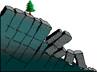
Simple block diagram to illustrate toppling and slide, via the BC Government
.
Meanwhile, in a comment on my previous post my good friend Tim Davies asked about the runout of the landslide, and in particular spectulated that the runout length might have been quite short. This ChinaNews image shows the full landslide track:-
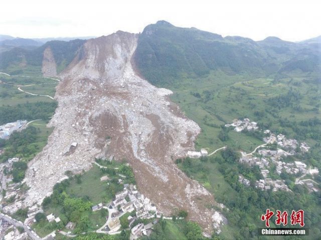
ChinaNews image of the Zhangjiawan rockslide
.
This suggests that whilst not being hyper-mobile, the track was probably not very short. There are some signs that the portion on the right side of the image has transitioned into a flow I think. Xinhua reports that the landslide volume was about 600,000 m³, with a fall height (I assume of the initial failure) of about 200 m.
I have not yet been able to locate this landslide reliably. Has anyone else had any luck?
31 August 2017
The Maca landslide: a large, slow-moving slide in Peru
The Maca landslide: a large, slow-moving slide in Peru
In an excellent article in Nature this week (Palmer 2017) discussing the importance of understanding slow-moving landslides, Jane Palmer features the Maca landslide in the upper Colca Valley in southern Peru. This landslide was also described in an article (Zerathe et al. 2016) published a year ago. This is a very complex landslide system, with components on both sides of the river. The image below shows one element – a large, active slide around about 1000 metres long on the northern side of the river:
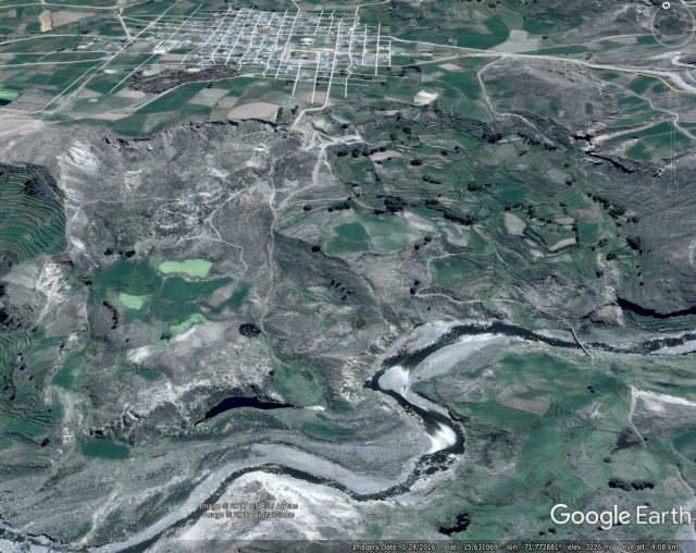
Google Earth image showing one component of the Maca landslide in Peru
Whilst on the other side of the river is a second broad component of the Maca landslide complex:
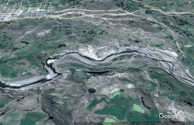
Google Earth image showing the other major component of the Maca landslide in Peru.
These images show the scale of the problem at Maca – Zerathe et al. (2016) calculated that the landslide complex has a total width of about 2.7 km, a length of about 1 km and affects an area of 1.7 km². The total volume is about 60 million m³. The morphology of the landslide is very complex, with multiple blocks bounded by active scarps (in effect faults), leading to patterns of movement that are similarly complex. This mirrors the findings of our studies of the Utiku (Massey et al. 2013) and Taihape (Massey et al. 2016) landslides in New Zealand. This complex topography is rather nicely shown in the following Panoramio photo by Daniel Horns:
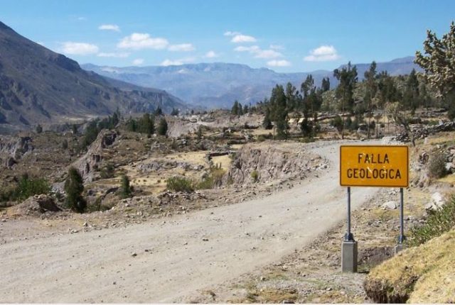
Panoramio image by Daniel Horns showing the upper part of the Maca landslide.
.
Zerathe et al. (2016) looked at the movement of the landslide on both long (decadal) and short (interannual) scales. They found that:
This study reveals three main driving factors acting at different timescales: (i) over several decades, the river course has significantly changed, causing the Maca landslide reactivation in the 1980s due to the erosion of its toe; (ii) at the year scale, a minimum amount of rainfall is required to trigger the motion and this amount controls the landslide velocity; (iii) transient changes in slide velocity may occur anytime due to earthquakes.
This is a pattern that we often see. Over longer timescales the landslide responds to changes to the overall geomorphic system, going through periods of comparatively rapid motion and periods of quiescence. In those movement periods the landslide responds to rainfall inputs, but in a highly non-linear manner because the rate of motion is so sensitive to groundwater level in which, beyond the threshold at which movement starts, small increases in groundwater level (pore water pressure) cause large increases in landslide velocity. And then of course in a tectonically-active area such as this, there is the unpredictable impact of earthquakes, although even in this case the amount of movement is probably also controlled by the groundwater level at the time of shaking.
Jane Palmer rightly points out that understanding these types of landslides is important. As Palmer (2017) puts it in relation to the Maca landslide:
The impact of this slow-moving landslide is clearly visible: in recent years, it has destroyed a section of the region’s main road and torn apart farmland, threatening the community’s key source of income. What is not clear is the landslide’s future: whether it will continue to lurch along as it always has or speed up dramatically, potentially endangering lives. “It’s like a sword of Damocles hanging over the town,” says Pascal Lacroix, a geoscientist at the Institute for Earth Science in Grenoble, France.
References
Massey, C.I., Petley, D.N., McSaveney, M.J. and Archibald, G. 2016. Basal sliding and plastic deformation of a slow, reactivated landslide in New Zealand. Engineering Geology, 208, 11-28.
Massey, C., Petley, D.N. and McSaveney, M. 2013. Patterns of movement in reactivated landslides. Engineering Geology 159, 1-19.
Palmer, J. 2017. Creeping earth could hold secret to deadly landslides. Nature, 548, 384–386.
Zerathe, S., Lacroix, P., Jongmans, D., Marino, J., Taipe, E., Wathelet, M., Pari, W., Smoll, L., Norabuena, E., Guillier, B., Tatard, L. 2016. Morphology, structure and kinematics of a rainfall controlled slow-moving Andean landslide, Peru. Earth Surface Processes and Landforms 41 (11), 1477-93.
30 August 2017
Before and after satellite images of the Pizzo Cengalo rock avalanche
Before and after satellite images of the Pizzo Cengalo rock avalanche
The clean up in the aftermath of the Pizzo Cengalo rock avalanche in Switzerland continues amidst reports of continued small-scale but significant ongoing landslide activity. Swissinfo reports that the search for the eight missing hikers has now been abandoned, whilst the reconstruction phase may take up to three years. The report also includes this slightly intriguing sections:
The landslide is one of the largest to hit Switzerland in the last century. Piz Cengalo had been under observation since 2011, when another – albeit largely unnoticed – landslide caused 1.5 million cubic metres of the mountainside to collapse.
The implication is that the section of slope that had been causing concern remains intact, but I may be misinterpreting what is meant here. I wonder if any readers have further information?
Meanwhile, the site of the landslide continues to be imaged by satellites, and cloud free images from before and after the event (in addition to the image during the collapse, about which I previously posted) are now available. This is a Planet Labs image from 4th August 2017, showing the site of the landslide before the collapse:-
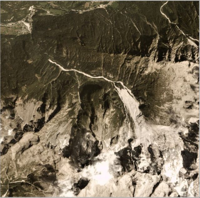
Planet Labs image of the site of the Pizzo Cengalo rock avalanche, dated 4th August 2017
.
And this image, dated 29th August 2017, shows the aftermath:-
.
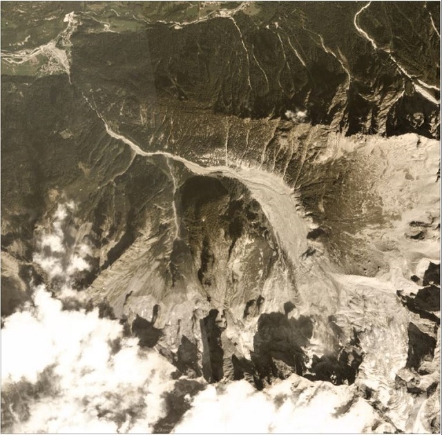
Planet Labs image of the aftermath of the Pizzo Cengalo rock avalanche, dated 29th August 2017
.
These two images nicely capture both the source of the landslide (i.e. the change is the scar area) and the new landslide deposit. Note that the volume of material that reached the village is quite small compared to the totral landslide volume, but there is now a huge amount of debris stored in the slopes above the settlement. This is the state of the village of Bondo itself:-
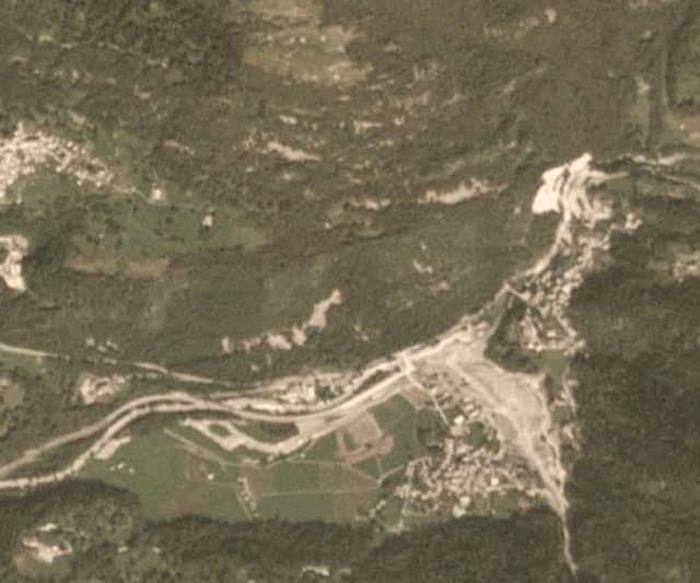
Planet Labs image dated 29th August 2017 showing the aftermath of the Pizzo Cengalo rock avalanche.
.
It is worth comparing that with this Google Earth image showing the same location in 2010, before the current landslide sequence began:-
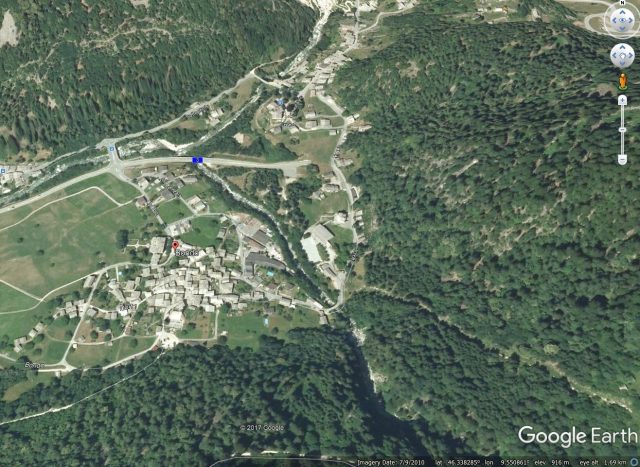
Google Earth image from 2010 showing the location of the village of Bondo before the current landslide sequence.
.
Acknowledgement
Planet Team (2017). Planet Application Program Interface: In Space for Life on Earth. San Francisco, CA. https://api.planet.com
29 August 2017
Zhangjiawan landslide: a massive rockslope collapse with 35 fatalities caught on a remarkable video
Zhangjiawan landslide: a massive rockslope collapse with 35 fatalities caught on a remarkable video
Whilst so much attention is focused on a very different, very serious disaster in Houston, another major landslide accident has occurred in China, this time in Zhangjiawan in Ghuizhou Province. Xinhua reports three known fatalities and 32 people missing; the likelihood of any further survivors is vanishingly small. The landslide occurred at 10:40 am yesterday (28th August) at Zhangjiawan Township, Nayong County. The slide buried 34 houses; seven people were recovered alive but injured.
Xinhua has two very impressive images of the landslide. This one provides a panoramic overview of the site:-
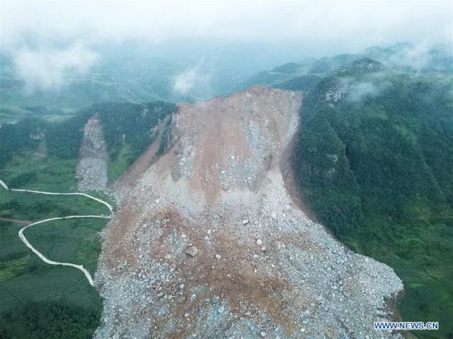
Xinhua image of the Zhangjiawan landslide in Nayong County, Guizhou Province
.
Whilst this one provides more detail of both the landslide source area and the deposit:-
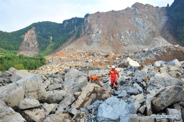
Xinhua image of the aftermath of the Zhangjiawan landslide in China
.
Perhaps most amazingly, this landslide was captured on a video that has been uploaded onto Youtube by CCTV:-
.
This appears to be a massive rockslide, with a fair amount of toppling as the landslide developed. Unusually for a non-seismic slide the failure seems to have developed from the ridge crest and then to have entrained debris from lower on the slope. The result is a landslide with a morphology that is more reminiscent of an earthquake-induced slide. It is notable that there is a high proportion of highly weathered material in the landslide, especially in the scar, much of which seems to have fallen from the upper part of the slope (the deposit itself is mostly intact rock blocks with a mantle of weathered material). This suggests perhaps that there was a highly weathered zone high on the slope that provided the structural weakness for the failure.
The trigger for the landslide is not clear, but this is of course the rainy season in China
25 August 2017
Pizzo Cengalo rock avalanche – Planet satellite imagery captured the landslide in motion
Pizzo Cengalo rock avalanche – Planet satellite imagery captured the landslide in motion
The Pizzo Cengalo rock avalanche in Switzerland on Wednesday has attracted considerable attention, not least because of the two amazing videos that were captured of the event. The first caught the initiation of the collapse and the initial development of the avalanche itself:-
.
And second the extraordinarily destructive nature of the flow some 5 km downstream:-
.
This is of course far from the first event on this mountain, although with eight people recorded missing it may be the most tragic. Given that it is well-studied I will allow others to write in detail about it, but would point out one fascinating aspect of the first video. This is an apparent shock wave (?) that appears to travel ahead of the main dust cloud immediately after the mass strikes the valley floor. I have tried to capture it in this screenshot:-
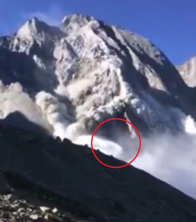
Possible shock wave from the Pizzo Cengalo rock avalanche? Via Youtube
.
I am no expert in these events, but given the speed with which this moves downslope I am hypothesising that this might be a shock wave? Can anyone else comment?
Perhaps even more interesting than that is a set of images from Planet Labs. One of their constellation of satellites was overhead at the time, and remarkably has captured the landslide in motion. This is an image taken on 4th August of the site of the Pizzo Cengalo rock avalanche:-
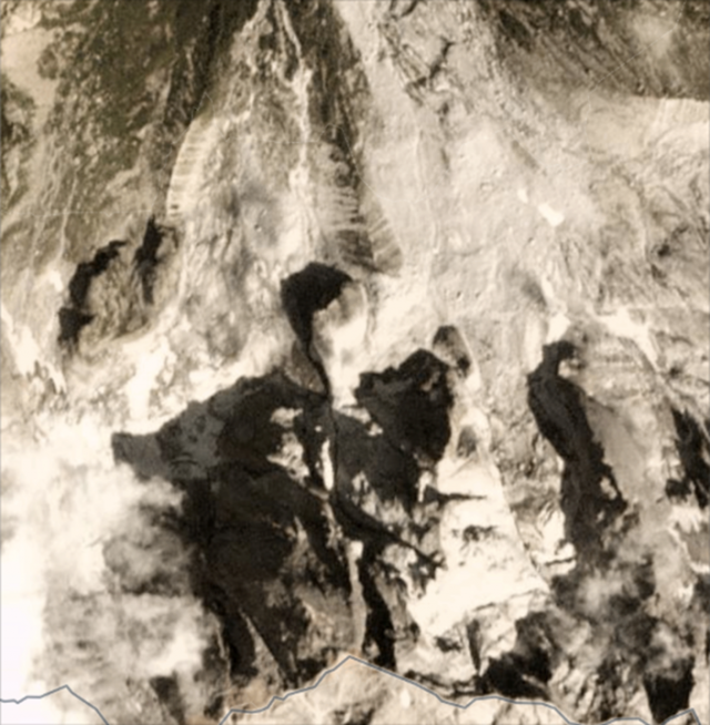
Planet Labs image of the site of the Pizzo Cengalo rock avalanche site, dated 4th August.
.
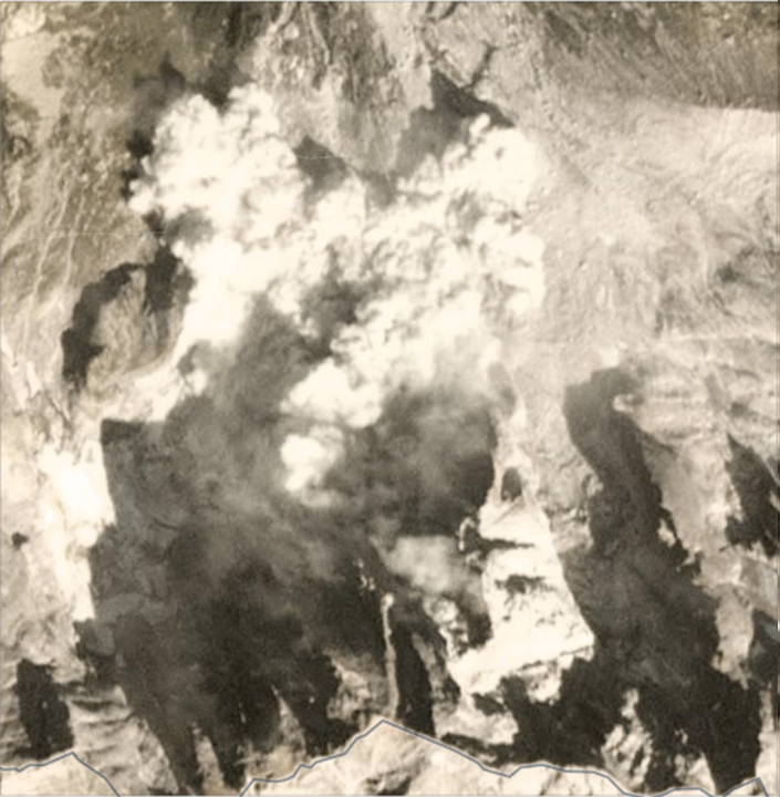
Planets Labs image of the Pizzo Cengalo rock avalanche in motion.
.
An even more fascinating aspect of this data is that the way in which the Planet Labs satellites collect imagery means that the near infrared (NIR) image is collected separately from the optical (RGB) imagery, with a 0.5 second gap between them. On this basis, Bas Altena from University of Oslo suggested that the movement might be visible in the imagery. The gap between these two images can be seen below – if you look carefully you can see that the dust clouds have moved in that 0.5 second period. This is the NIR image (which has a lower resolution):-
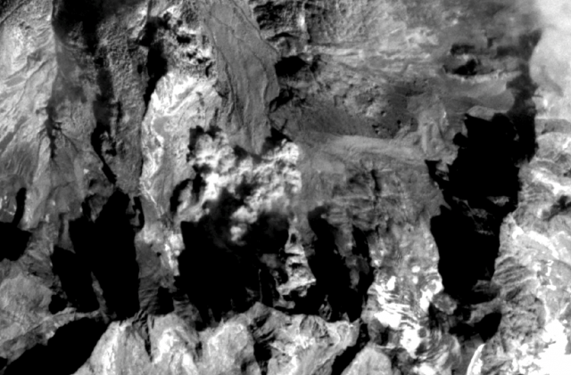
Planet Labs NIR image of the Pizzo Cengalo rock avalanche in motion.
.
And this, half a second later, is the Red band of the optical imagery:
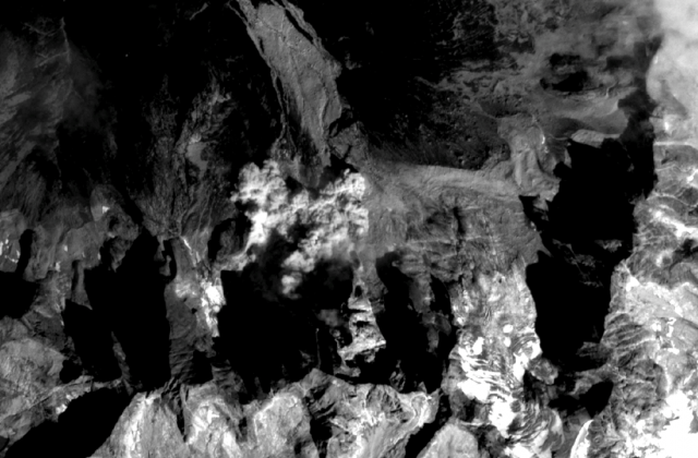
Planet Labs Red band image of the Pizzo Cengalo rock avalanche in motion
.
Acknowledgement
Planet Team (2017). Planet Application Program Interface: In Space for Life on Earth. San Francisco, CA. https://api.planet.com
Thanks in particular to Joe Mascaro of Planet Labs, who pointed out that this event had been captured, Bas Altena from University of Oslo who suggested the RGB/NIR trick, and to various friends who have tweeted, left comments and emailed me about this amazing event.
22 August 2017
The Zuta Village landslide: another example of a high mobility slide
The Zuta Village landslide: another example of a high mobility slide
I have written on several occasions of late about high mobility landslides, both in the context of the Regent landslide in Sierra Leone and the Oso landslide in Washington State. As an aside full mapping is now available of the track of the extraordinary Regent landslide – as expected this was a channelised flow all the way to the coast. Another very interesting example popped up in my Google Alerts yesterday, although the landslide occurred in early July. This example is the Zuta Village landslide, which occurred during heavy rainfall in Hunan Province, central China, on 1st July. The landslide killed nine people and injured a further 19. This image, from Xinhua, provides an overview of the landslide:-
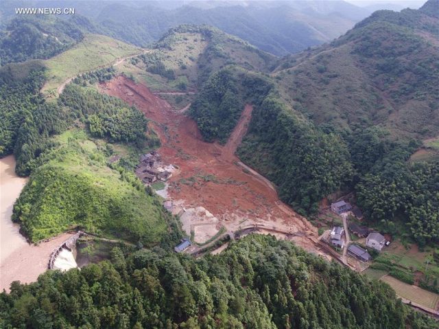
Overview of the Zuta Village landslide, via Xinhua.
.
This view provides a better indication of the source area of the landslide:-
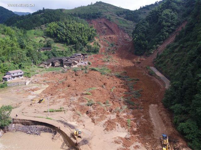
Detail of the Zuta Village landslide, via Xinhua.
.
This appears to be a comparatively shallow translational failure in deeply weathered soil that has transitioned into a high mobility flow, presumably through some sort of liquefaction process. There are marked similarities with the Regent landslide in terms of material and mobility, although in this case the mass has not been able to channelise. The nature of the sliding surface in the source area is also unclear, but the image below suggests the involvement of at least some intact rock:-
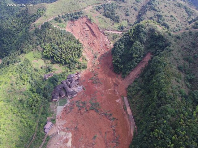
Detail of the Zuta Village landslide in China, via Xinhua.
.
As an aside, this set of images also illustrates the ways in which humans can contribute to increased landslide risk. The source area of the landslide is traversed by a road cut into the slope and appears to have been partially deforested. And, separately, a house has been built into the slope, as this detail from the above images shows:-
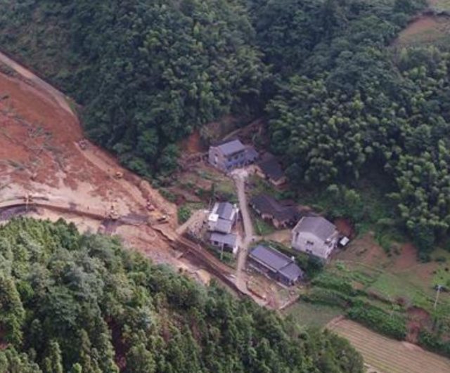
Detail from one of the Xinhua images showing the site of the Zuta Village landslide.
.
To build this house forest has been stripped and slopes cut, increasing the likelihood of failure. Even worse the building is at the exit of a gully draining a substantial, steep catchment. The first image shows that this catchment has been substantially deforested. This must be subject to debris flow risks. On first inspection this is a further landslide accident in the making.
 Dave Petley is the Vice-Chancellor of the University of Hull in the United Kingdom. His blog provides commentary and analysis of landslide events occurring worldwide, including the landslides themselves, latest research, and conferences and meetings.
Recent Comments