
28 March 2023
Alausí: a massive landslide in Ecuador
Posted by Dave Petley
Alausí: a massive landslide in Ecuador
The 26 March 2023 landslide at Alausí in Ecuador has attracted considerable attention, having buried a neighbourhood of the town. At the time of writing the confirmed loss of life is seven people, with a further 23 having been injured. It is reported that 64 people are missing, although there will be considerable uncertainty in that number. Earlier reports of 16 fatalities are now thought to be incorrect.
The best overall view of this very large landslide is a drone video collected by Edwin Salazar that has been widely tweeted:-
https://twitter.com/canarvaezm/status/1640328603198971907
.
The drone successfully captures a very deep-seated, rotational landslide in comparatively homogenous, but clearly weak, rocks. I would suspect that these might be volcanic materials?
Meanwhile, AP has a remarkable image of the toe of the landslide, and the immense damage that it has caused to the town of Alausí:-
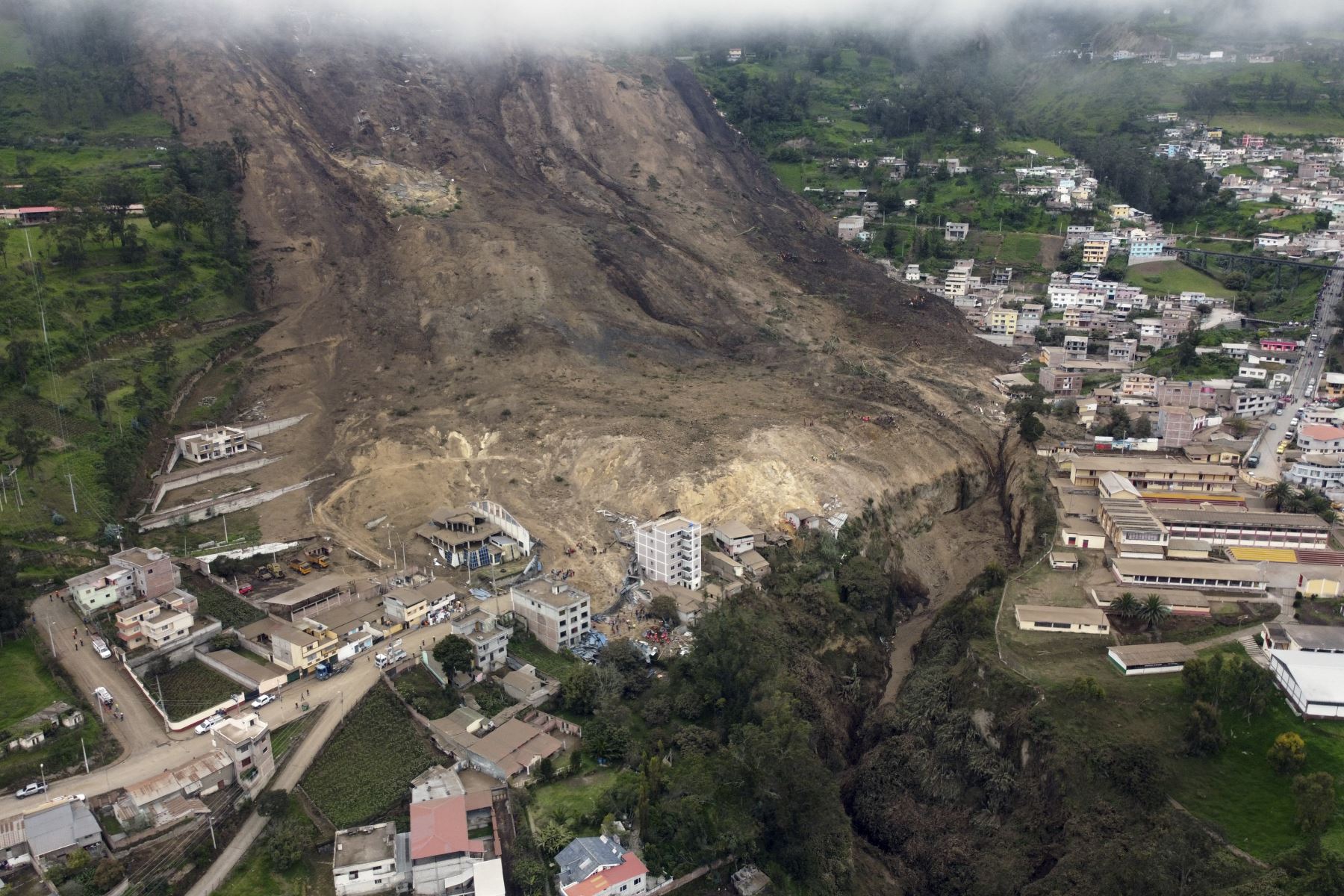
The toe of the very large 26 March 2023 landslide at Alausí in Ecuador. Image by AP via Andina.
.
This is roughly the same perspective from Google Earth, giving an idea of what has been lost in this lower portion:-
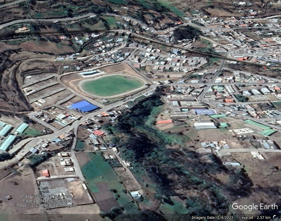
Google Earth image of the site of the very large 26 March 2023 landslide at Alausí in Ecuador.
.
The location of the landslide is [-2.193, -78.843]. This is the best image that I have found that shows the entire landslide:-
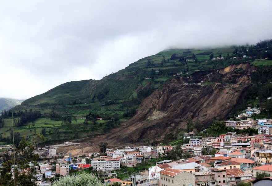
The very large 26 March 2023 landslide at Alausí in Ecuador. Image by REUTERS/Karen Toro.
.
Reports indicate that the area has suffered heavy rainfall in recent days, which is also hindering the rescue operations. The area has been on yellow alert for landslides since 15 March 2023.
In terms of Alausí itself, there are reports that cracks started to appear in the area of the landslide in December 2022, and that irrigation water had ceased to flow in the area. The reports also indicate that some monitoring was ongoing at the site.
It is interesting to take a wider perspective on the area around Alausí:-
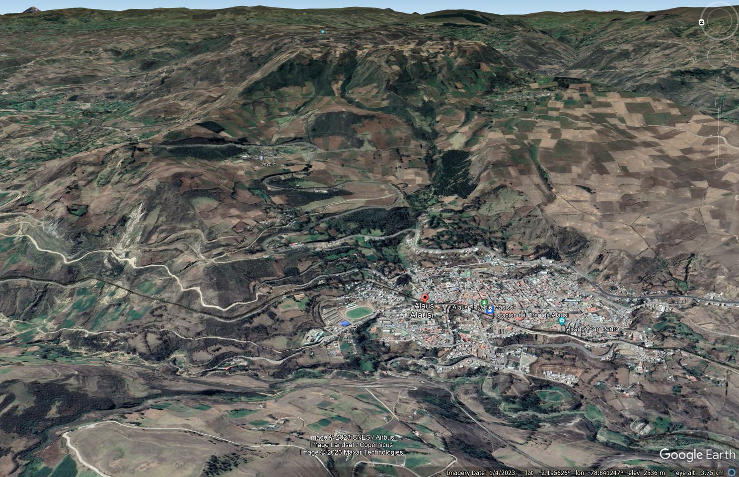
Google Earth image of the landscape around Alausí in Ecuador.
.
This is a landscape dominated by landslides. On the left side of the image are multiple shallow failures on steep slopes, many of which are affecting the road. But on the steep slopes around Alausí there are multiple arcuate scars that probably mark the source zones of previous landslides, many of which would have been much larger than the event on Sunday. The largest of these might lie in the upper portion of the in the centre of the image, where there is a very large, arcuate scar and, downslope to the right, the possible remains of a degraded landslide block. This is, of course, only a hypothesis – more detailed mapping would be needed to confirm the theory.
 Dave Petley is the Vice-Chancellor of the University of Hull in the United Kingdom. His blog provides commentary and analysis of landslide events occurring worldwide, including the landslides themselves, latest research, and conferences and meetings.
This landslide is very close to the 2021 chunchi landslide, which you talked about in previous posts… Any similarities?
This town is the first significant mountain town on the historic railroad from the coast to Quito. The tracks ran right down ‘main street’. In the Earth image they are the straight line near the top, crossing the ravine on the ‘Puente Negro`. The landslide covers a long stretch of those old tracks. It may also have blocked E35 a major NS highway.
The railroad is no longer used, except for some on-and-off tourist and recreational uses, especially around the “devil’s nose” switchbacks a short distance to the south.
It is really sad to see all this happen and to think that the loss of many Lives could have been avoided, especially Humble and Poor people, everything indicates that local and national Authorities did NOTHING to prevent it, KNOWING that the cracks in the Earth began 3 months ago. I saw a boy’s youtube video who was studying at the University of Riobamba who lost his entire Family, Father, Mother, Brothers, Nephews, a total of 11 members and most of them cannot be found yet.
Thanks for your blog.