
24 March 2023
A remarkable landslide at Karl Marx village, in Jalpak-Tash, Kyrgyzstan
Posted by Dave Petley
A remarkable landslide at Karl Marx village, in Jalpak-Tash, Kyrgyzstan
On the night of 22 March 2023 a landslide was triggered at Karl-Marx village in Jalpak-Tash rural municipality, Uzgen in Kyrgyzstan. The landslide is reported to be 1 million cubic metres. AKI Press has a posted a drone video of this event onto Youtube – it is breathtaking:-
.
This is a still from the video:-
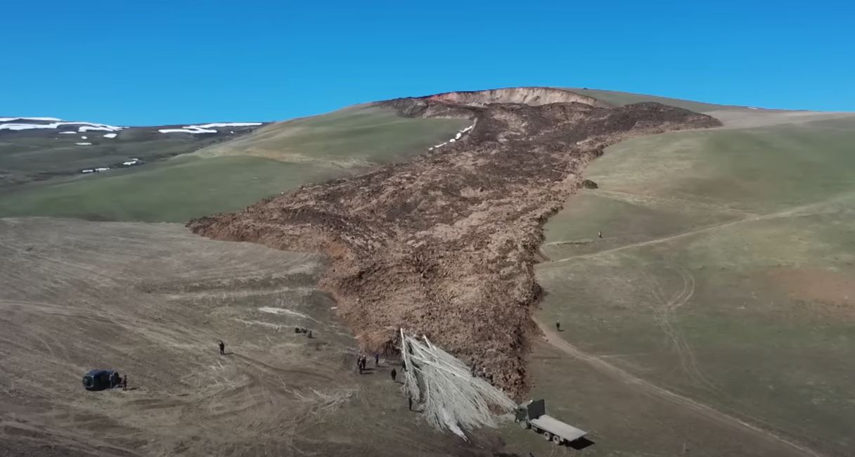
The 22 March 2023 landslide at Karl-Marx in Jalpak-Tash rural municipality in Kyrgyzstan. Still from a video posted to Youtube by AKI Press.
.
The image below shows the upper portion of the landslide, including the source area:-
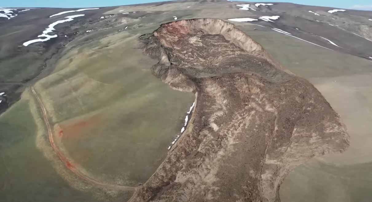
The source area of the 22 March 2023 landslide at Karl-Marx in Jalpak-Tash rural municipality in Kyrgyzstan. Still from a video posted to Youtube by AKI Press.
.
Whilst the image below shows the landslide track:-
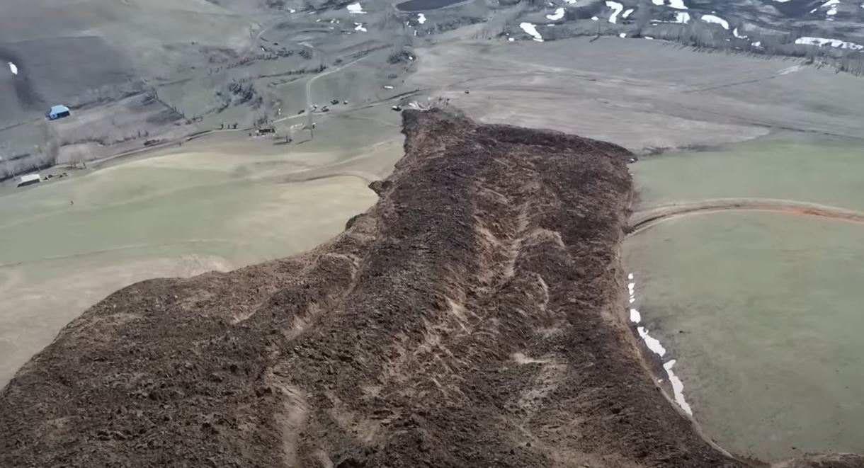
The track of the 22 March 2023 landslide at Karl-Marx in Jalpak-Tash rural municipality in Kyrgyzstan. Still from a video posted to Youtube by AKI Press.
.
The head scarp area of the Jalpak-Tash landslide shows a reasonably deep seated landslide source, with possibly a minor rotational component to the failure. The main part of the landslide track appears to me to be an earthflow. The video seems to indicate that the landslide was still creeping at the time of the failure.
The location of this landslide is unclear to me, but research suggests that it might be close to Kurbu-Tash, which is at [40.611, 73.293]. This area suffered a large landslide that I highlighted in 2017, which was not dissimilar to the 22 March 2023 event. This remains to be confirmed.
An AKI Press article reports that an emergency situation has been declared for the village, with the residents of 18 houses having been evacuated, but that the risk is considered to be low. The rate of movement has been recorded at about 3 metres per hour.
The trigger for this landslide is not given, but this will be snowmelt season in this part of Kyrgyzstan. The 2017 landslide also occurred in the Spring.
 Dave Petley is the Vice-Chancellor of the University of Hull in the United Kingdom. His blog provides commentary and analysis of landslide events occurring worldwide, including the landslides themselves, latest research, and conferences and meetings.
Interesting flow-slide. and impressive video
I have not been able to pin point it yet but noticed the following in the vicinity (last variable is bearing in degrees)
[40.6230,73.283,060] pretty recent
[40.6178,73.2716,335] ditto more of a flow than earth?
[40.6121,73.2669,330] somewhat older and more degraded + vegetation
Most likely, this landslide-flow was triggered by a strong earthquake that occurred 7 hours before the landslide in the Hindu Kush zone. The characteristics of this seismic event are as follows: M = 6.7, epicenter 40 km SSE of Jurm, Afghanistan: Time 2023-03-21 22:47:23 (UTC+06:00), Location 36.523°N 70.979°E Depth 187.6 km.
The strongest Hindu Kush earthquakes are felt in a large area of Central Asia, including in Kyrgyzstan. In Kyrgyzstan and Uzbekistan, at distances of 300-400 km from the Hindu Kush epicentral zone, the intensity of these earthquakes does not exceed 4-5 points, they are distinguished by a low-frequency spectrum and a significant duration of seismic vibrations, reaching 2 minutes or more. Swarms of relatively weak (M = 3.8-4.5) Hindu Kush earthquakes that occur continuously in the spring for several days (2002, 2003, 2008) are no less dangerous for initiating landslides.
Reference: Torgoev I., Nijazov R., Havenith H.-B. Tien-Shan landslides triggered by earthquakes in Pamir-Hindukush zone // In Margottini C., Canuti P. and K. Sassa (Eds.), Landslide science and Practice, vol. 5. Springer Verlag, Berlin Heidelberg, 2013. – pp. 191–197.
I think you may be right about the earthquake trigger. When I first looked at the images of this landslide i noticed that the headwall scarp is deep, 20m+, but that no stratigraphy is evident. But It has taken me a day to think about whether these are loess slopes. I think they are. I don’t have a map of loess deposits from that area but a quick literature check suggests that they are. I also turned up the following reference:
Geophysical investigation and dynamic modelling of unstable slopes: case-study of Kainama (Kyrgyzstan)
G. Danneels, C. Bourdeau, I. Torgoev and H.-B. Havenith
Geophysical Journal International 2008 Vol. 175 Issue 1 Pages 17-34
I have not had time to track events and locations down but I think seismic triggering of loess ar high water contents would be a good contender and also fit in with the spatial pattern.