
5 May 2020
The Sardoba dam failure: flood routing
The Sardoba dam failure: flood routing
After my blog post yesterday about the 1 May 2020 Sardoba dam failure in Uzbekistan, several people have asked about the flood routing between the breach and the large inundated area that I showed in my post. The Planet Labs imagery shows this clearly, and it is quite an interesting story.
We can start with the area around the dam – the Planet Labs image below shows the breach in the lower left and the now partially drained reservoir:-
Flood routing from the Sardoba Dam failure in action. Planet Labs PlanetScope image captured on 3 May 2020. Copyright Planet Labs, used with permission.
.
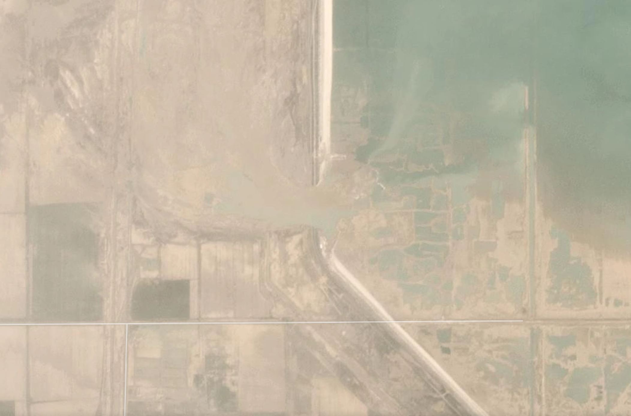
Scouring immediately downstream of the breach is clear, and there is a distinct channel that follows the wall of the dam, initially towards the north and then towards the east. This is shown in more detail below:-
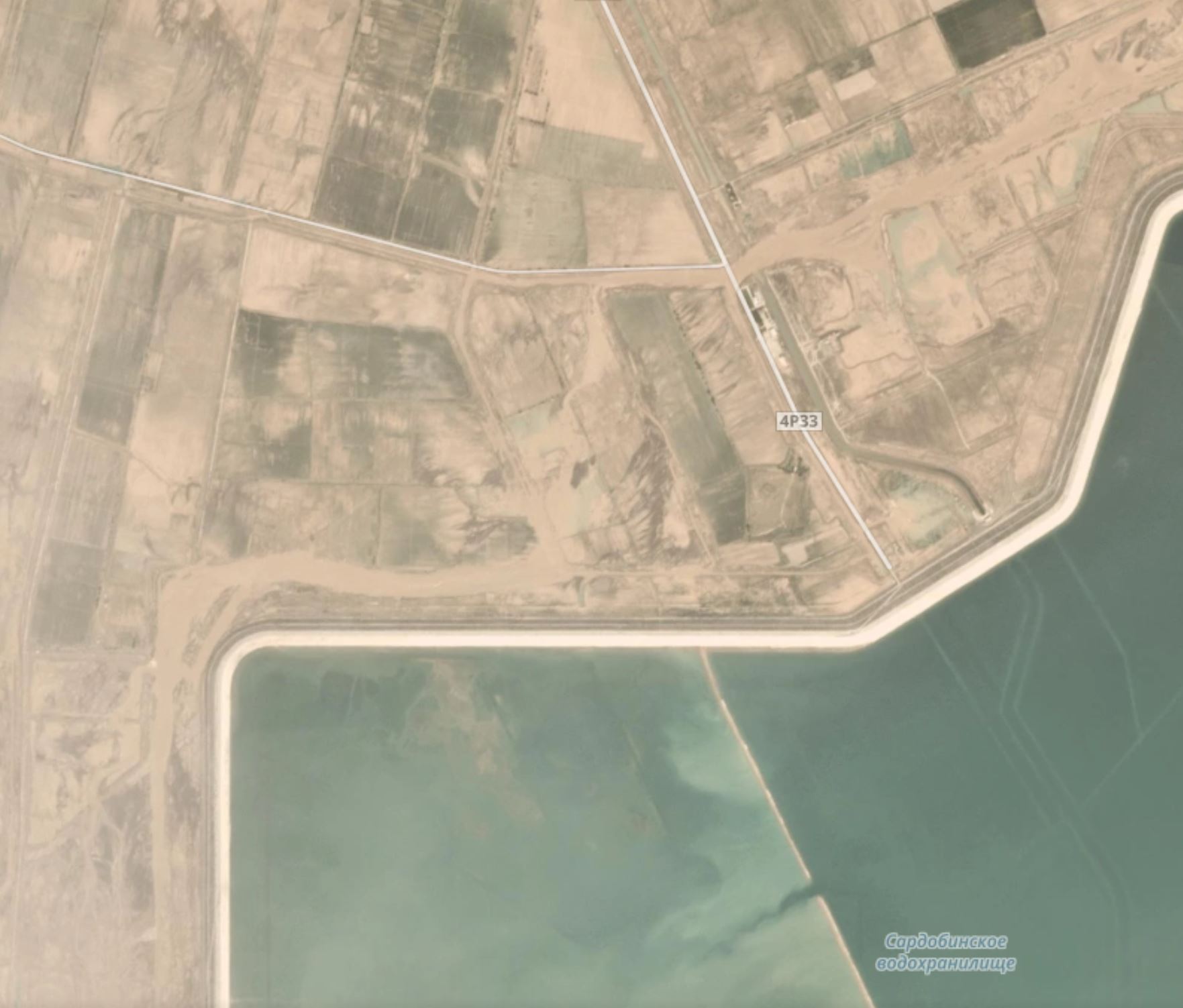
Flood routing from the Sardoba Dam failure in action. Planet Labs PlanetScope image captured on 3 May 2020. Copyright Planet Labs, used with permission.
.
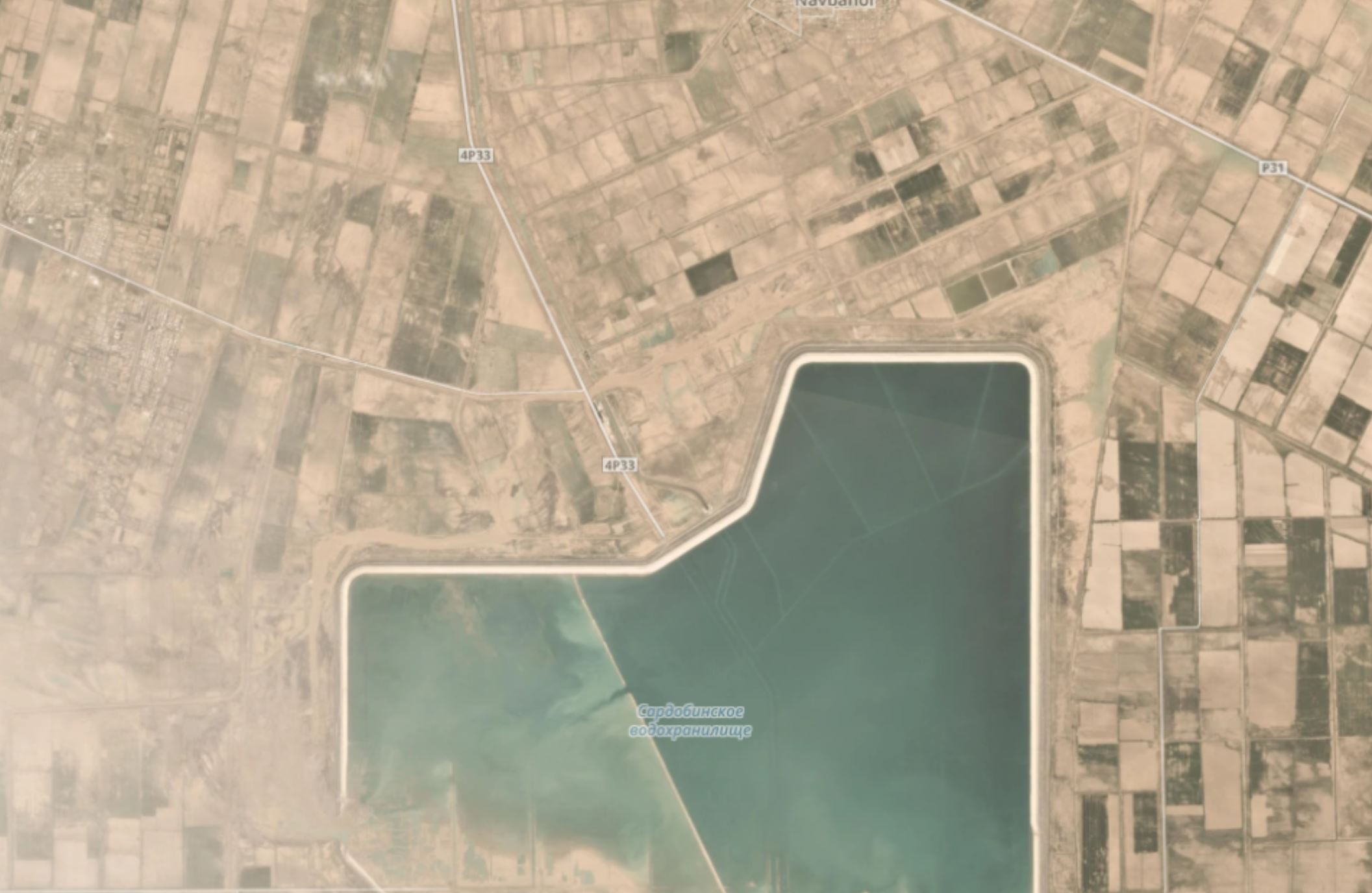
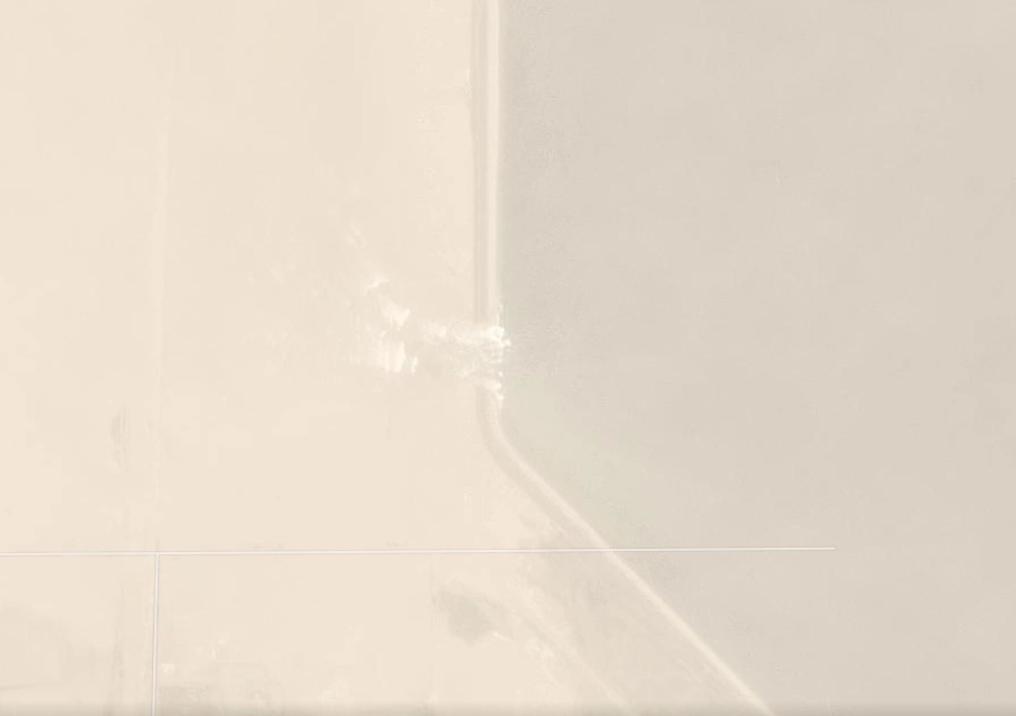
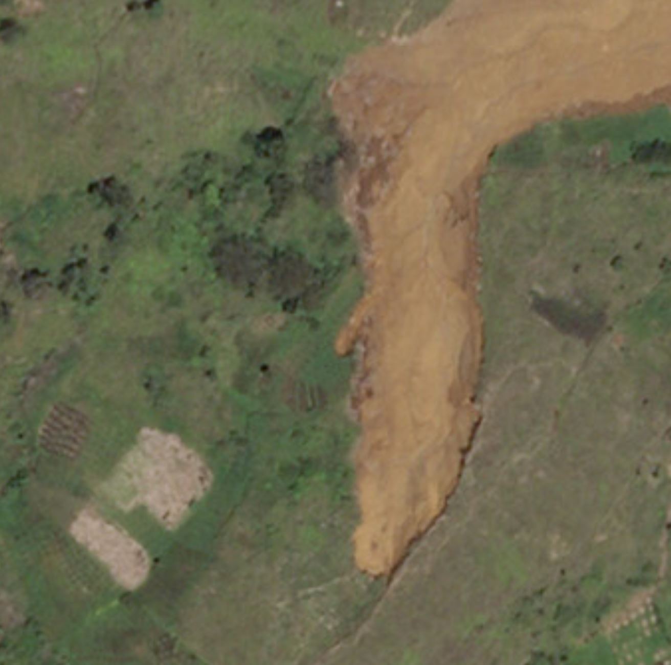
There is also evidence from the images that the water inundated a much larger area in the vicinity of the dam, and on 3 May 2020 there was still some evidence of minor flooding. From there, the water spread across a broad area rather then being channelised, as the image below illustrates:-
Flood routing from the Sardoba Dam failure in action. Planet Labs PlanetScope image captured on 3 May 2020. Copyright Planet Labs, used with permission.
.
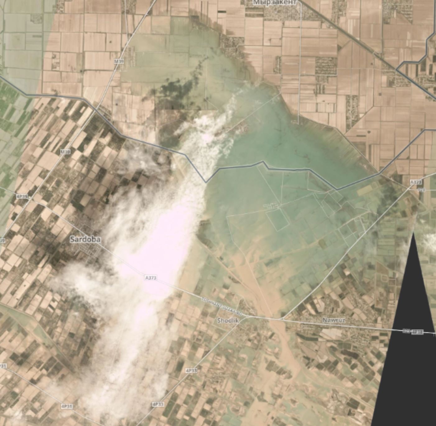
In this image there is extensive damage to the fields (and presumably to the villages) across a wide area. Towards the northeast there are areas that remain submerged, and at the top of the image the flow has channelised once more as the water moved into the extensively ponded area that I showed yesterday. The imagery collected on 4 May 2020 shows that this area remains deeply flooded.
Thus the Planet Labs satellite imagery demonstrates that the Sardoba dam failure has caused flood damage over a broad area of this part of Uzbekistan.
.
On reflection 1: EGU General Assembly Day 2
Today is day 2 of the EGU2020 virtual meeting. This is the list of the landslide sessions on Day 2 – it is a busy landslide day:-
NH3.5 Debris flows: advances on mechanics, monitoring, modelling and risk management
Displays Chat Tue, 05 May, 14:00–18:00
NH3.1 Large slope instabilities: characterisation, dating, triggering, monitoring and modelling
.
On reflection 2: recent landslides
Uganda and Kenya continue to be battered by heavy rain and resultant floods and landslides, whilst a landslide in New York State has left houses teetering on the edge of disaster. In China, the early part of the rainy season is just getting under way.
Reference
Planet Team (2020). Planet Application Program Interface: In Space for Life on Earth. San Francisco, CA. https://www.planet.com/
4 May 2020
Sardoba Reservoir: a major dam collapse in Uzbekistan on 1 May 2020, plus the EGU2020 Day 1 programme and a car crash interview about diversity in the geosciences
Sardoba Reservoir: a major dam collapse in Uzbekistan on 1 May 2020, plus the EGU2020 Day 1 programme and a car crash interview about diversity in the geosciences
On Friday 1 May 2020 a major collapse occurred in the earth-filled dam of Sardoba Reservoir in Uzbekistan, causing extensive flooding. The video below, posted to Youtube, shows the breach with water pouring through, and the development of the resultant flooding:-
.
News reports suggest that up to 70,000 people were evacuated and 50 people were injured. An investigation has been launched.
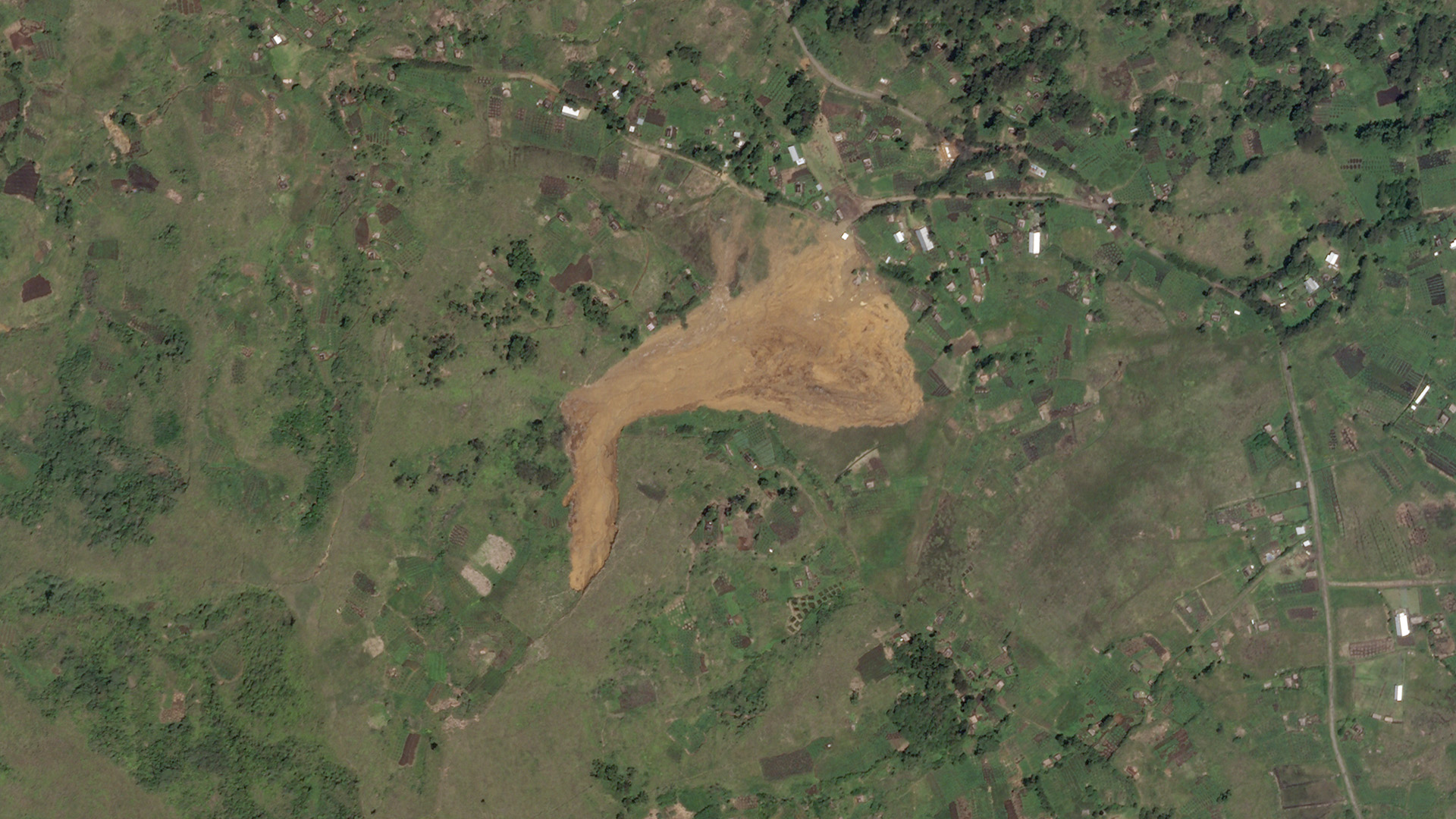
The dam is comparatively new – most reports suggest that the reservoir was completed in 2017 – suggesting that there was either a design or a construction error. The location is 40.337, 68.421. Below is a Google Earth image, from 2019, showing the embankment. I have pinpointed where the failure occurred. At the time of the image the reservoir was not full:-
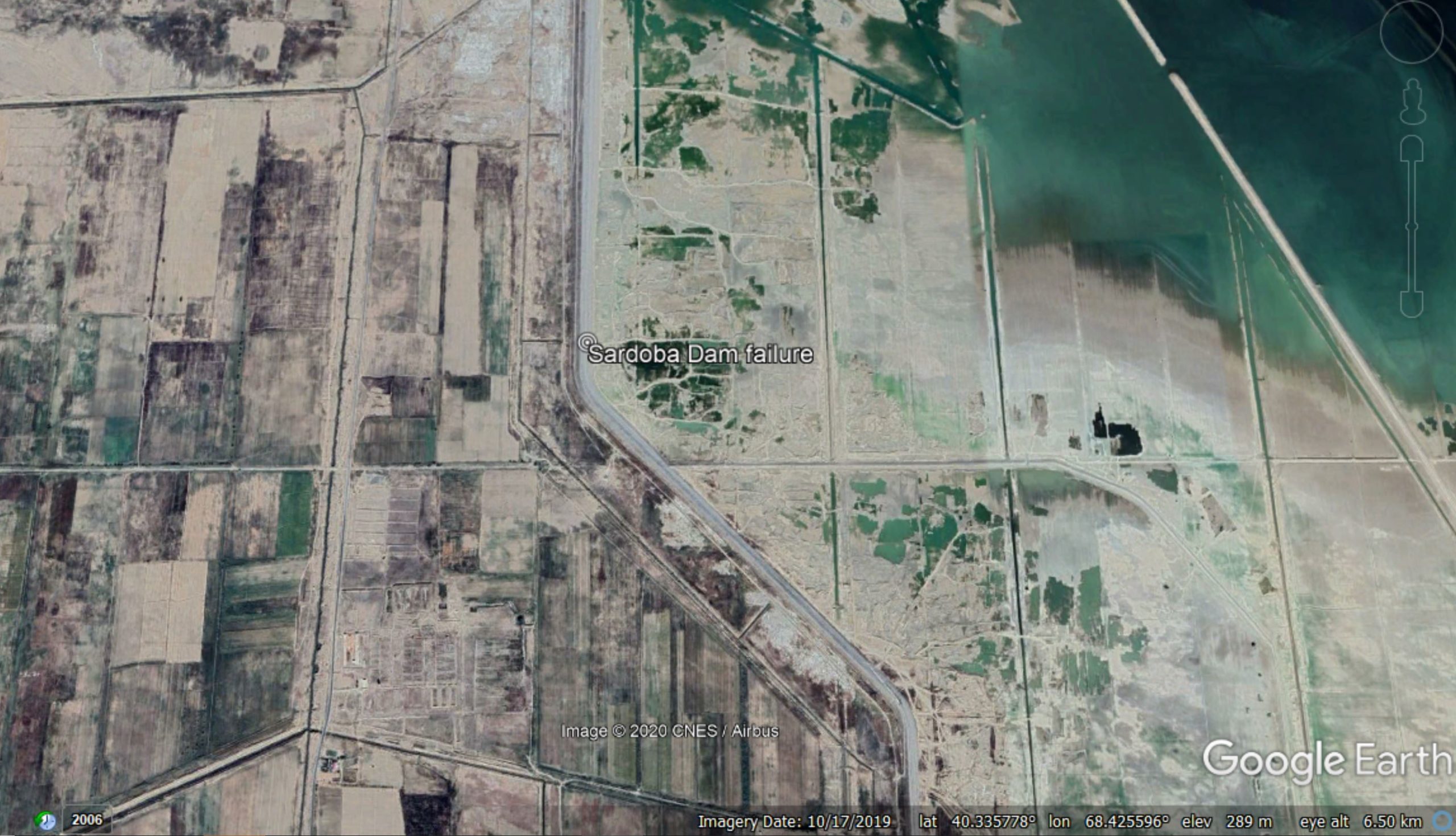
Google Earth image of the location of the Sardoba Dam failure on 1 May 2020.
.
Planet Labs have captured a slightly hazy but admirably clear image of the site of the dam failure:-
The location of the Sardoba Dam failure. Planet Labs PlanetScope image captured on 3 May 2020. Copyright Panet Labs, used with permission
.
Note the breached embankment, the drained reservoir and the clear downstream erosion and outwash deposits. Interestingly, the image from 1 May 2020, the day of the breach, we affected by haze or high altitude cloud. However, the image does capture the ongoing failure of the structure:-
The Sardoba Dam failure in action. Planet Labs PlanetScope image captured on 1 May 2020. Copyright Planet Labs, used with permission,
.
This image, also from 3 May 2020, shows the very extensive flooding downstream:-
Flooding from the Sardoba Dam failure in action. Planet Labs PlanetScope image captured on 3 May 2020. Copyright Planet Labs, used with permission.
.
On reflection 1: EGU General Assembly Day 1
Today is the start of the EGU2020 virtual meeting. This are the landslide sessions on Day 1 (this time I have included submarine landslides too):-
.
On reflection 2: 1970s attitudes towards diversity from the President of the AAPG
This interview with the President of the American Association of Petroleum Geologists is simply jaw-dropping:-
It is hard to know where to start with this. There is a need for some serious self-reflection by the individual and the organisation.
Reference
Planet Team (2020). Planet Application Program Interface: In Space for Life on Earth. San Francisco, CA. https://www.planet.com/
1 May 2020
Dona Juana: a large garbage landslide in Bogota
Dona Juana: a large garbage landslide in Bogota
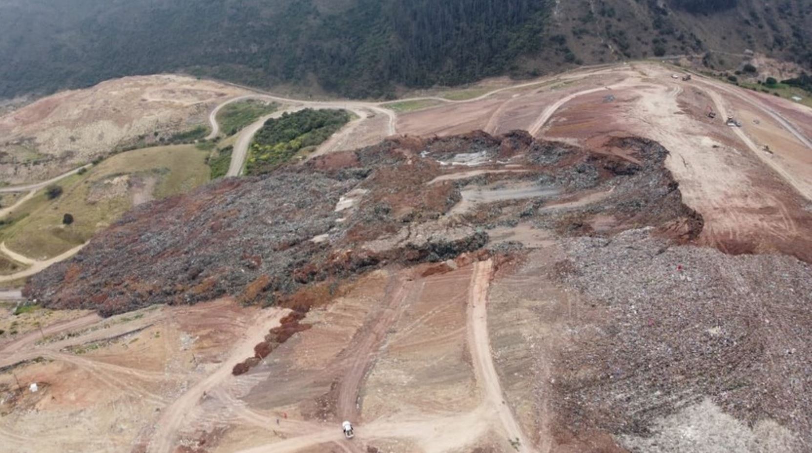
On Tuesday 28 April 2020 a large garbage landslide occurred at the Dona Juana waste site on the outskirts of Bogota in Colombia. Fortunately there were no casualties. News reports suggest that it had a volume of about 60,000 cubic metres. The images are quite spectacular:-
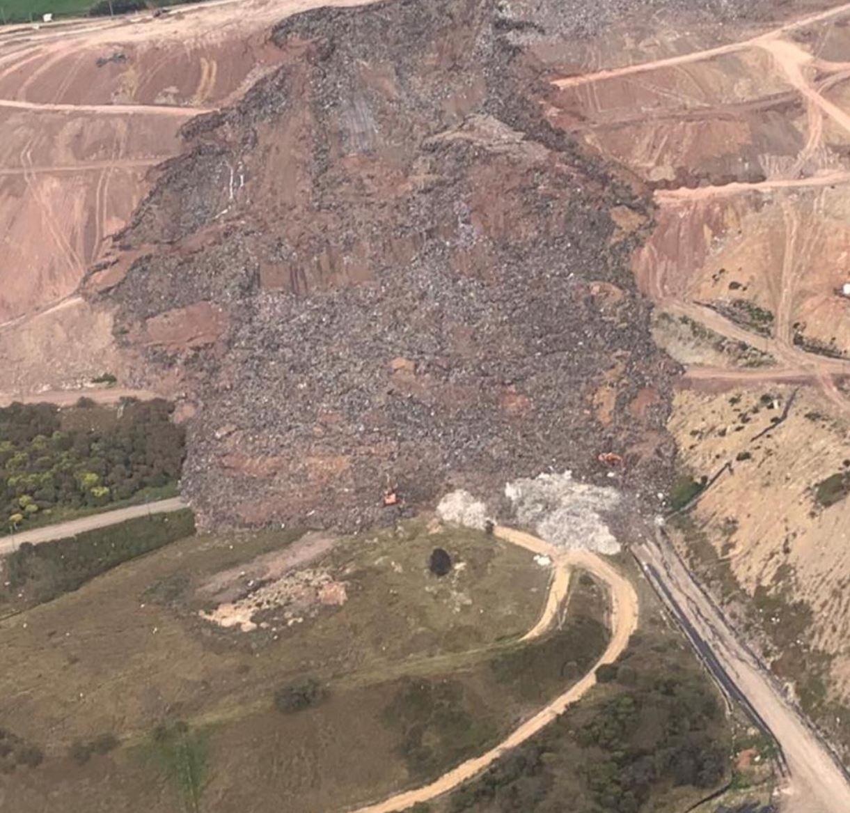
The 28 April 2020 Dona Juana garbage slide in Bogota. Image via BluRadio. Note the backhoes at the foot of the landslide, which provide a scale.
.
Side view of the Dona Juana garbage landslide on 28 April 2020. Image tweeted by @OscarFlorezO.
.
RTE has a news report about the landslide, providing some useful background. News reports in Colombia suggest that concerns have been raised in recent weeks about the performance of the private sector operator of this extremely large landfill site, although there is little detail as to the concerns.
Fortunately the images suggest that although this slide has a large area the depth is not particularly great. The slide appears to be translational in nature, which raises the question as to whether the process of emplacing the waste has created a weak surface that has allowed sliding to occur. Whatever the cause, garbage piles are always made by people, so the failure is ultimately human error of one sort or another.
Interestingly, the Dona Juana landfill site underwent a much larger landslide in 1997, with an estimated mass of about 700,000 tonnes. There is a paper on ResearchGate providing details of that event. In that case the landslide appears to have been quite deep-seated, and to have been a consequence of poor management of the leachate (water that has percolated through, and been generated within, the waste) and the biogas generated within the garbage. A failure to provide adequate drainage pathways allowed high pore water pressures to be generated, promoting instability.
I suspect that the cause of the failure at Dona Juana this week is rather different, but is just as unacceptable.
30 April 2020
EGU General Assembly 2020: the online landslide sessions

EGU General Assembly 2020: the online landslide sessions
Next week (4 – 8 May 2020) is the online version of the EGU General Assembly 2020, which is the largest annual meeting of the landslide research community. EGU is organising the meeting online due to the cancellation of the physical meeting during the Corona Virus crisis. At this stage one can only speculate on what this meeting will look like in 2021.
This is how EGU describe the online meeting:-
EGU2020: Sharing Geoscience Online (#shareEGU20) brings part of the activities of the EGU General Assembly 2020 online. We hope that authors and conveners will join us in sharing their research and discussing with colleagues. From 4 to 8 May 2020 (CEST) everyone can join us online for their favourite sessions.
Participation in EGU2020: Sharing Geoscience Online does not require payment of a registration fee. For uploads of presentation materials and commenting, authors and participants only need to have a Copernicus user account. Viewing abstracts and presentation materials does not require any authentication. Participating in text-based session chat channels requires the provision of a nickname and your email address. To organize your participation, please consider preparing your personal programme. To learn more about the chat channels, please see our page on how to use the chats.
I thought it would be helpful to summarise the main landslide sessions, which are part of the Natural Hazards programme group. I have organised these chronologically, the times are of course Central European Summer Time:
Monday
Tuesday
NH3.5 Debris flows: advances on mechanics, monitoring, modelling and risk management
Displays Chat Tue, 05 May, 14:00–18:00
NH3.1 Large slope instabilities: characterisation, dating, triggering, monitoring and modelling
Wednesday
Displays Chat Wed, 06 May, 08:30–12:30
Thursday
Displays Chat Thu, 07 May, 10:45–12:30
Friday
29 April 2020
West Pokot: channelised debris flows killed up to 40 people in Kenya on 18 April 2020
West Pokot: channelised debris flows killed up to 40 people in Kenya on 18 April 2020
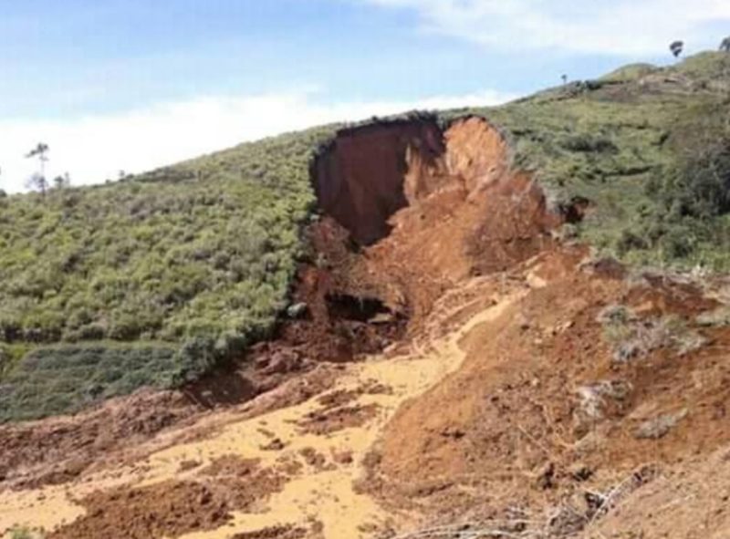
The team at the new Hazmapper tool have tweeted about a set of major landslides that occurred in the West Pokot area of Kenya on 18 April 2020. Reports about the impact of these landslides, which primarily hit the villages of Kipchumwa and Chesegon, vary, but The Star reports that 29 people have been confirmed to have been killed and a further 20 are missing. Reports also suggest that 18 people were injured and a further 4000 have been displaced. The location, as identified by the Hazmapper team, is 1.28°, 35.61°.
As such, this is the most serious landslide event worldwide of the year to date, although as we move into May and the development of intense rainfall across Asia, this will surely be beaten soon.
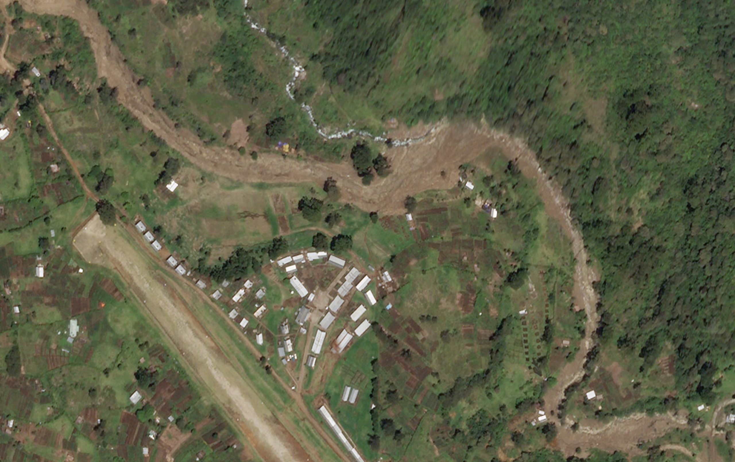
Images in the media suggest that these were channelised debris flows originating from slips high on the hillsides. The image below, published in khusoko.com, provides an overview of the situation:-
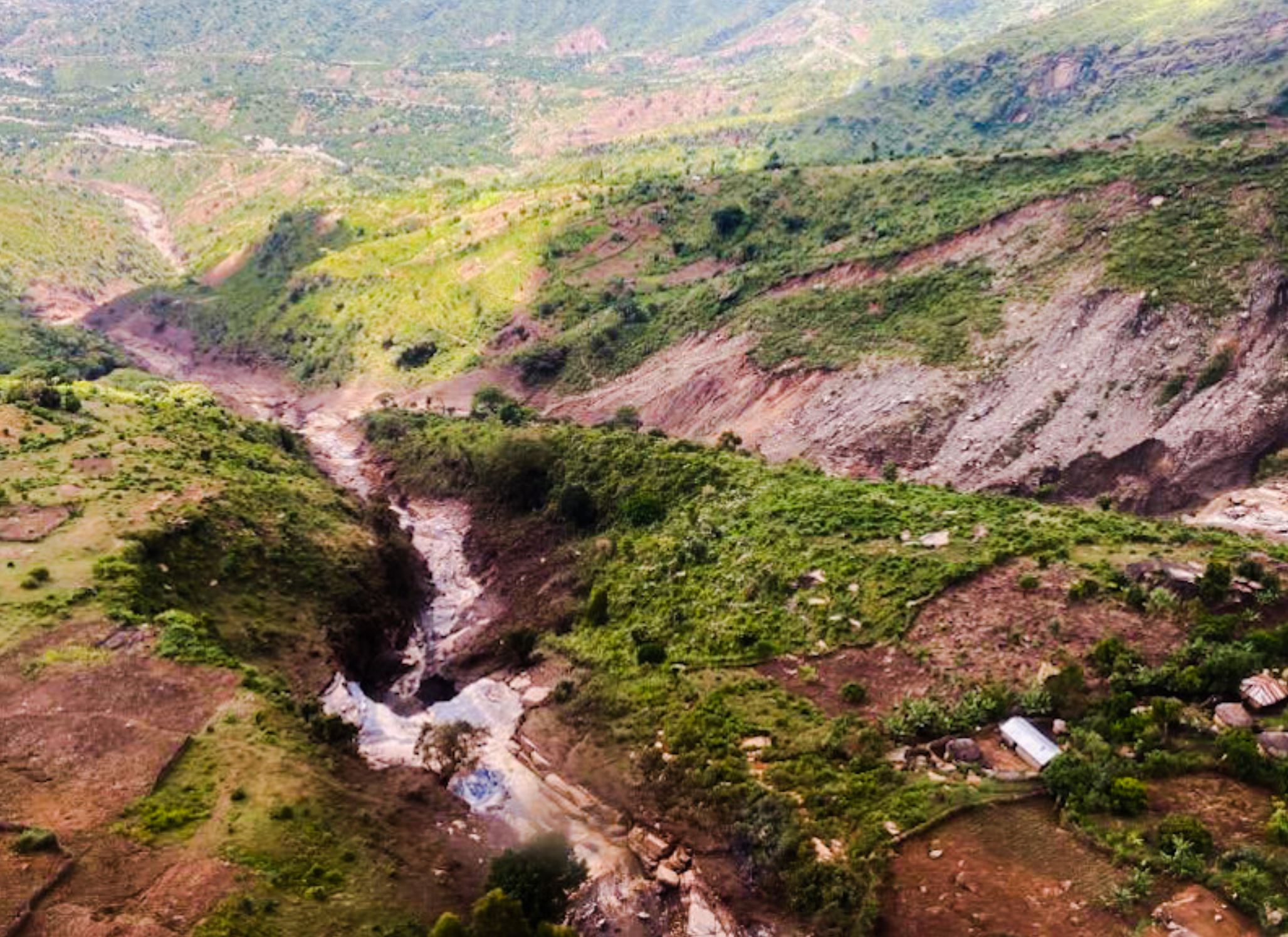
The channelised debris flows at West Pokot in Kenya. Image by Kipchumba Murokomen, posted on khusoko.com.
.
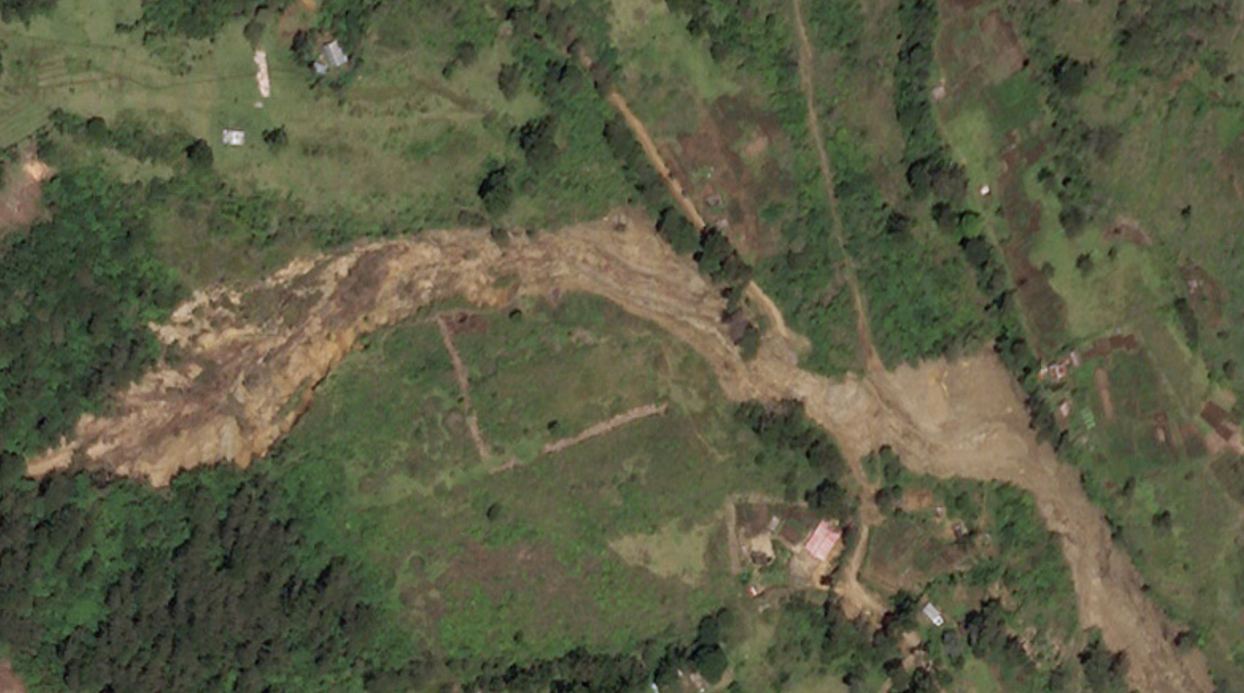
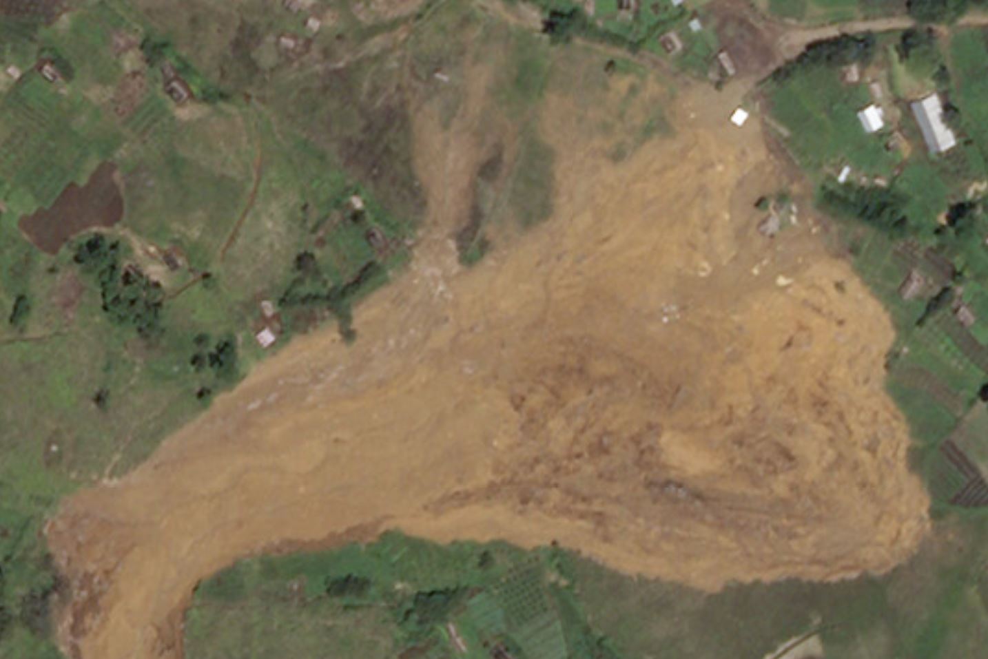
The team at Hazmapper have started the process of mapping these landslides, although this is difficult given the high occurrence of cloud cover in this area. Planet Labs have an image that shows well a part of the landslide sequence at West Pokot though:-
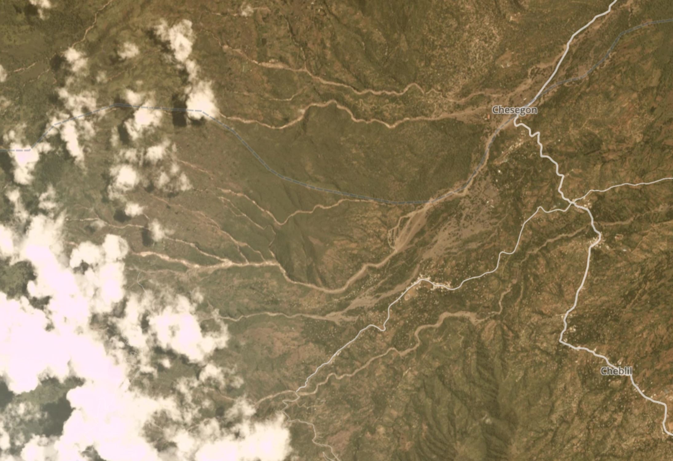
Planet Labs PlanetScope image of the West Pokot landslides, collected on 27 April 2020. Copyright Planet Labs, used with permission.
.
The image shows several channelised flows, in many cases originating from multiple smaller channels high on the hillslopes. It is clear that these flows have spilled out of the channels on the lower slopes, which would explain the high casualty rate. To be caught in such an event is almost unimaginably horrific.
West Pokot is no stranger to these events. Late last year I posted about another set of landslides in this area, on 28-29 November 2019, which killed an estimated 50 people.
In the last year I have recorded far more fatal landslides across Africa than has been the case in the past.
Reference
Planet Team (2020). Planet Application Program Interface: In Space for Life on Earth. San Francisco, CA. https://www.planet.com/
28 April 2020
Planet Labs high resolution imagery of the Kegesuglo landslide in Papua New Guinea
Planet Labs high resolution imagery of the Kegesuglo landslide in Papua New Guinea
Yesterday I posted Planet Labs high resolution satellite imagery of the Tendepo landslide in Papua New Guinea. Amazingly, they also captured a high-resolution image of the 10 April 2020 Kegesuglo landslide, which killed 10 people. As I noted at the time:
On Friday 10 April 2020 a large landslide was triggered, probably by rainfall at Kegesuglo in Kundiawa-Gembog district in Papua New Guinea. The location of this landslide appears to be -5.833, 145.1. This is a remote, hilly location at the foot of Mount Wilhelm, the highest mountain in Papua New Guinea. It’s worth noting that in some reports the village is named Keglsugl.
This is a rather different landslide from Tendepo, starting with a smaller failure but transitioning into a channelised debris flow. This is the high-resolution image:-
Planet Labs SkySat image of the Kegesuglo landslide, collected on 21 April 2020. Copyright Planet Labs, used with permission.
.
Many thanks again to my friends at Planet Labs, and in particular to Robert Simmon, for obtaining this wonderful image. It shows the initial failure very clearly in the top left corner,, and then the transition into a channelised flow. The image below provides more detail of the initial failure:-
Planet Labs SkySat image of the source area of the Kegesuglo landslide, collected on 21 April 2020. Copyright Planet Labs, used with permission.
.
It is interesting to note that the crown of the landslide appears to be located in an area that retains tree cover. The landslide has started as what in Hong Kong would be termed an open hillslope failure, cutting a broad swathe across the slope. On the right side it intercepts the channel, and transitions onto a channelised flow, as shown below:-
Planet Labs SkySat image of the track of the Kegesuglo landslide, collected on 21 April 2020. Copyright Planet Labs, used with permission.
.
In this phase the landslide has been strongly steered by the existing channel, but in places it has spilled out onto the adjacent terrain. These types of channelised flows are particularly hazardous to people in their path. In many ways this is a smaller version of the massively destructive 2017 Regent landslide in Sierra Leone.
In both of the landslides in Papua New Guinea that I have featured more work is needed to understand why these slides have occurred. These are areas of the country that have undergone significant environmental degradation through the removal of forest cover, but in both cases there is no obvious reason as to why these particular slopes have failed. It is very likely that these areas will suffer further such events; understanding where and when they might occur is important.
Reference
Planet Team (2020). Planet Application Program Interface: In Space for Life on Earth. San Francisco, CA. https://www.planet.com/
27 April 2020
Planet Labs high resolution imagery of the Tendepo landslide
Planet Labs high resolution imagery of the Tendepo landslide
Last month I noted that on Saturday 21 March 2020 the significant Tendepo landslide occurred in Tambul-Nebilyer district in Papua New Guinea, resulting in 12 fatalities. This landslide was triggered by heavy rainfall.
Planet Labs have, once again, very kindly collected high resolution imagery of this landslide (and indeed the one at Kegesuglo, which I will post this week) – thanks once again to all at Planet Labs, especially Robert Simmon, for obtaining the amazing images.
This is the SkySat image, collected on 18 April 2020:-
Planet Labs SkySat image of the Tendepo landslide, collected on 18 April 2020. Copyright Planet Labs, used with permission.
.
The source of the landslide is to the southwest, with the landslide initially moving towards the north, before following the topography to flow in a generally eastward direction. It is clear that the landslide has spread considerably. This is a more detailed view of the source:-
Planet Labs SkySat image of the source area of the Tendepo landslide, collected on 18 April 2020. Copyright Planet Labs, used with permission.
.
This is clearly a quite deep-seated landslide in residual soil. Note the very linear feature on the southeast portion of the scar, which appears to extend beyond the boundary of the landslide to the south. This would seem to indicate that the landslide has exploited an existing weakness. This can be seen in the image below from my original post:-
Tendepo landslide: the scar of the major landslide in Tambul-Nebilyer district in Papua New Guinea on 21 March 2020. Image by Caligen Giluwe Ice via The Watchers.
.
After failure the landslide has changed direction and spread across the lower angled slope:-
Planet Labs SkySat image of the deposit of the Tendepo landslide, collected on 18 April 2020.
.
I suspect that there is some entrainment of soil in the upper portion of this part of the landslide, with deposition starting at about the half way point, probably controlled by slope gradient. The greatest volume of material appears to have been deposited in the south-east part of the slide. I suspect that there is some evidence of excavation to recover victims towards the toe.
It is very rare to get decent information about landslides in Papua New Guinea, even though they are a substantial hazard. Thus, this Planet Labs imagery has provided rare and invaluable insight into the problems there.
Reference
Planet Team (2020). Planet Application Program Interface: In Space for Life on Earth. San Francisco, CA. https://www.planet.com/
24 April 2020
The Luming Mine tailings spill: so what happened next?
The Luming Mine tailings spill: so what happened next?
A month ago I posted on a number of occasions about the major release of tailings from the storage facility at Luming Mine in China on 28 March 2020. Using high-resolution satellite imagery provided by Planet Labs we pieced together the sequence of events, which involved the failure of a decant tower in the middle part of the tailings pond. This subsequently proved to be correct – Adam Thomas from CGG Satellite Mapping highlighted to me that the WISE Uranium Project now have an entry for this tailings release:-
| Date | Location | Parent company | Ore type | Type of Incident | Release | Impacts |
|---|---|---|---|---|---|---|
| 2020, Mar. 28 | Tieli, Yichun City, Heilongjiang Province, China | Yichun Luming Mining Co., Ltd |
molybdenum | “No. 4 overflow well” [decant tower?] of the tailings dam tilted, resulting in the release of supernatant water and tailings through a drainage tunnel, while the embankment itself remained intact | 2.53 million m3 | water and tailings flowed through surrounding area, reaching Yijimi river after 3 km, threatening the drinking water resource of 68,000 people in Tieli City; by Apr. 4, the pollution reached 208 km downstream |
.
So many thanks to you all for your hard work on piecing this together. It is another beautiful example of crowd-sourcing an answer to a geotechnical conundrum.
I thought it would be interesting to go back to the site of the Luming Mine tailings release to see what has happened since. This is a Planet Labs PlanetScope (3 m resolution) image of the site, collected on 15 April 2020:-
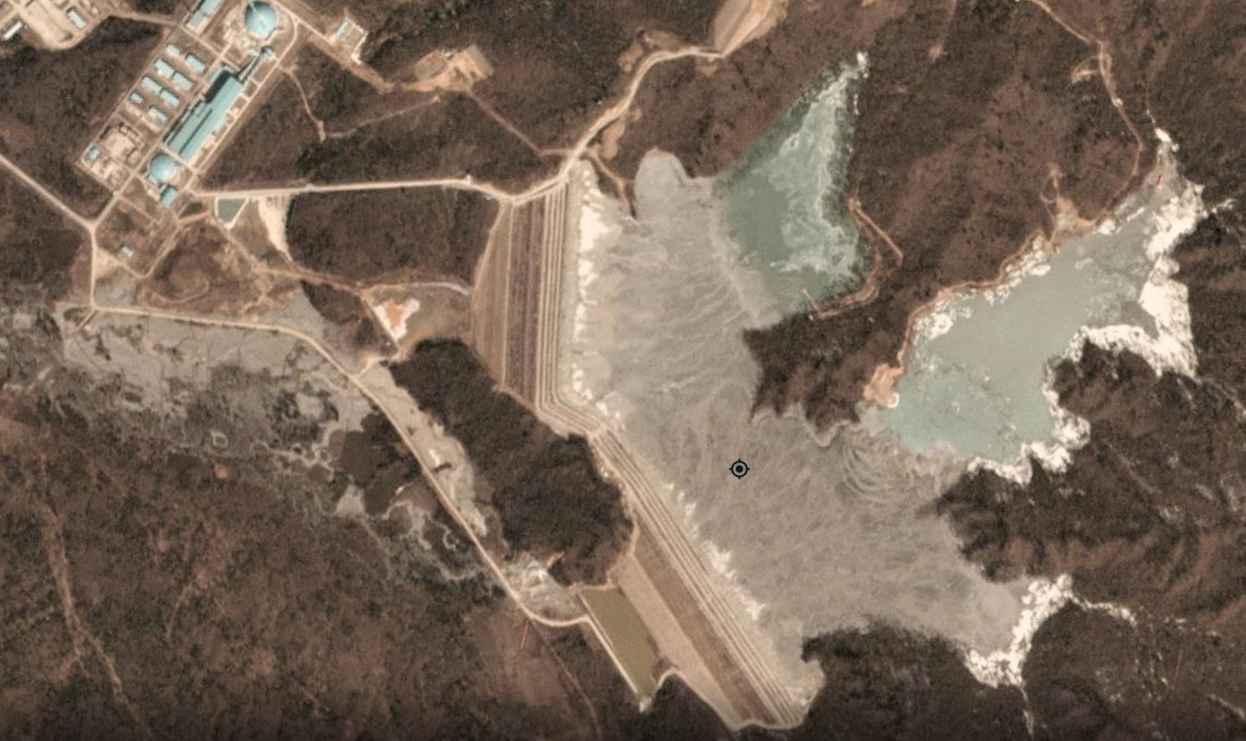
A satellite image of the aftermath of the Luming mine tailings release. Copyright Planet Labs, used with permission. Image collected 15 April 2020.
.
The image shows to the right of the centre the work that was undertaken to build a platform out to the site of the collapse of the decant tower and to plug it, preventing further tailings releases from this location. These works are shown in images after the accident. The deformation in the tailings around this point is still evident.
Meanwhile the large volume of tailings downstream of the dam remains in place.
A news report (in Chinese) provides some further insight into the situation. It states that 2.53 million cubic metres of tailings were released, making this a very large event. The tailings have now traveled 200 km downstream, and on 19 April 2020 an emergency response was initiated by the Yichun City authorities. Finally, it reports that production at the mine remains suspended.
Reference
Planet Team (2020). Planet Application Program Interface: In Space for Life on Earth. San Francisco, CA. https://www.planet.com/
23 April 2020
A major fly ash failure and release at Singrauli in India – Planet Labs images
A major fly ash failure and release at Singrauli in India – Planet Labs images
On 10 April 2020 a major collapse occurred of a fly ash retaining structure at Singrauli in Madhya Pradesh in India. The South Asia Network on Dams, Rivers and People (SANDRA) has a detailed article on this collapse, which occurred in a storage pond for the Sasan Ultra Mega Power Project near to the village of Harrahva in Singrauli district. The collapse and subsequent debris flow killed six people and inundated fields for a distance of about 5 km downstream.
The site of the breach is 23.95, 82.22 – there is good Google Earth imagery of the site. This is a Planet Labs image showing the site on 9 April 2020, the day before the fly ash failure:-
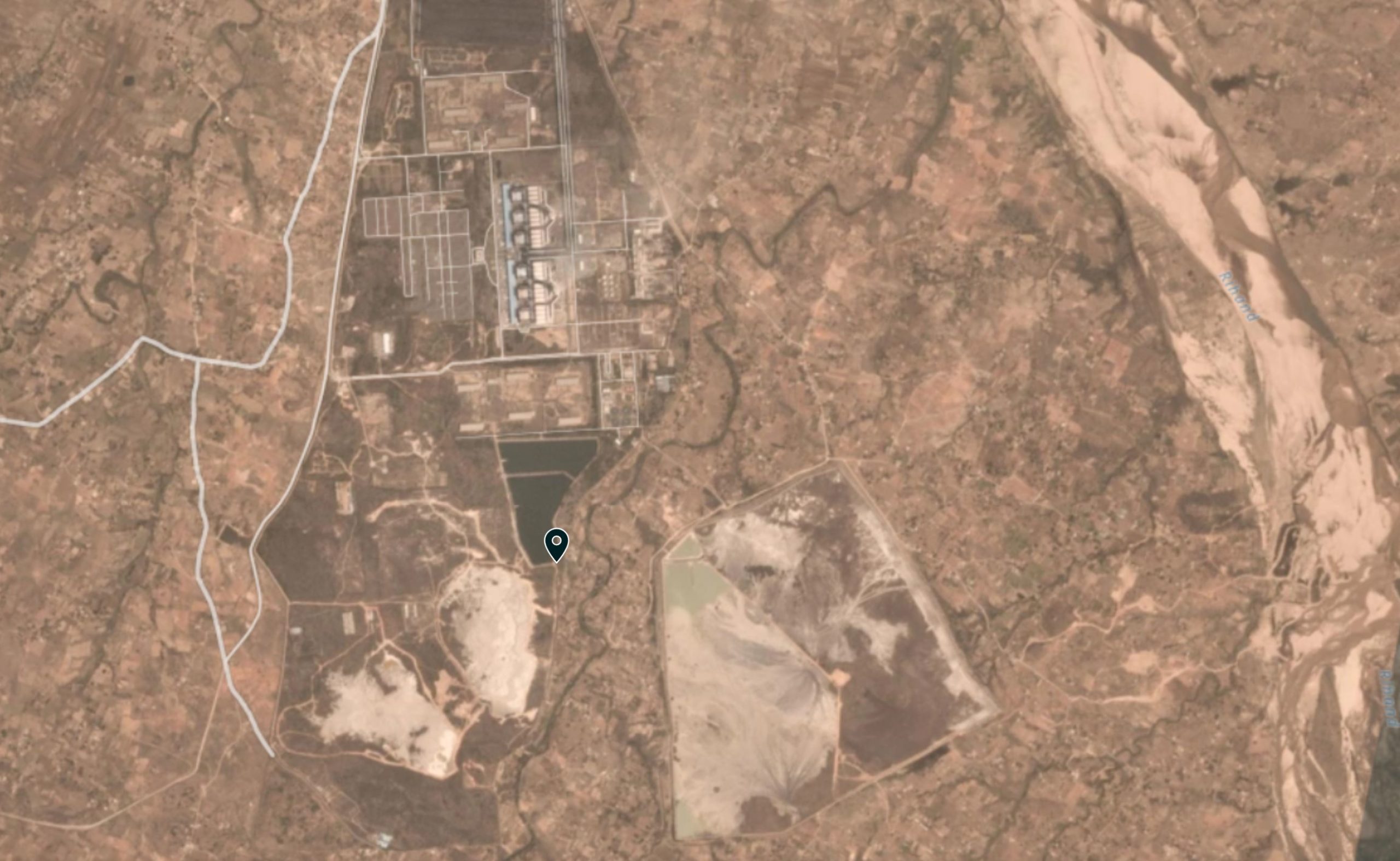
Planet Labs image of the Singrauli fly ash failure. Image captured on 9 April 2020, copyright Planet Labs, used with permission.
.
Whilst this is the image from 12 April 2020, showing the breach and the release of the fly ash, and the inundated area downstream:-
Planet Labs image of the aftermath of the Singrauli fly ash failure. Image captured on 12 April 2020, copyright Planet Labs, used with permission.
.
Interestingly, this appears to be a comparatively new fly ash storage facility. Google Earth imagery from September 2018 does not show any storage at this particular location.
The SANDRP article indicates that this is the third such incident in India in the last year:-
First in August 2019, there was breach in artificial pond of Essar Power Company and then in October 2019 a similar incident had taken place in Vindhyachal super thermal power plant owned by NTPC in the district. Both the incidents had caused wide scale destruction.
Back in 2009, when this blog was still on its old site, I posted about a major fly ash failure in Tennessee. That post is still visible, albeit with slightly odd formatting.
Reference
Planet Team (2020). Planet Application Program Interface: In Space for Life on Earth. San Francisco, CA. https://www.planet.com/
22 April 2020
Zongling: an area of intense landslide activity in Guizhou Province, China
Zongling: an area of intense landslide activity in Guizhou Province, China
A very nice, open access paper (Wang et al. 2020) has just been published in the journal Landslides exploring a new technique for the analysis of InSAR data for measuring the deformation of mass movements. As I have noted previously, InSAR is one of the most exciting areas of landslide science at the moment, providing the opportunity to both detect potentially dangerous slopes and to monitor their movement remotely. Wang et al. (2020) describe a new approach, an improved Interferometric Point Target Analysis (IPTA) method, to analyse these complex datasets, demonstrating that for the study sites at least it is able to provide detailed information about the behaviour of the slope.
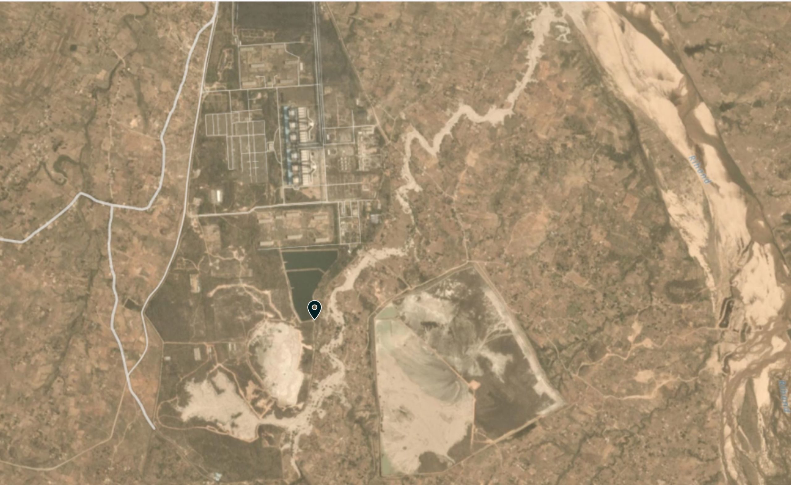
The site for this study is Zongling in Guizhou Province, China. The article describes a very interesting set of landslides – the location is 21.718, 105.265 – go and take a look on Google Earth:-
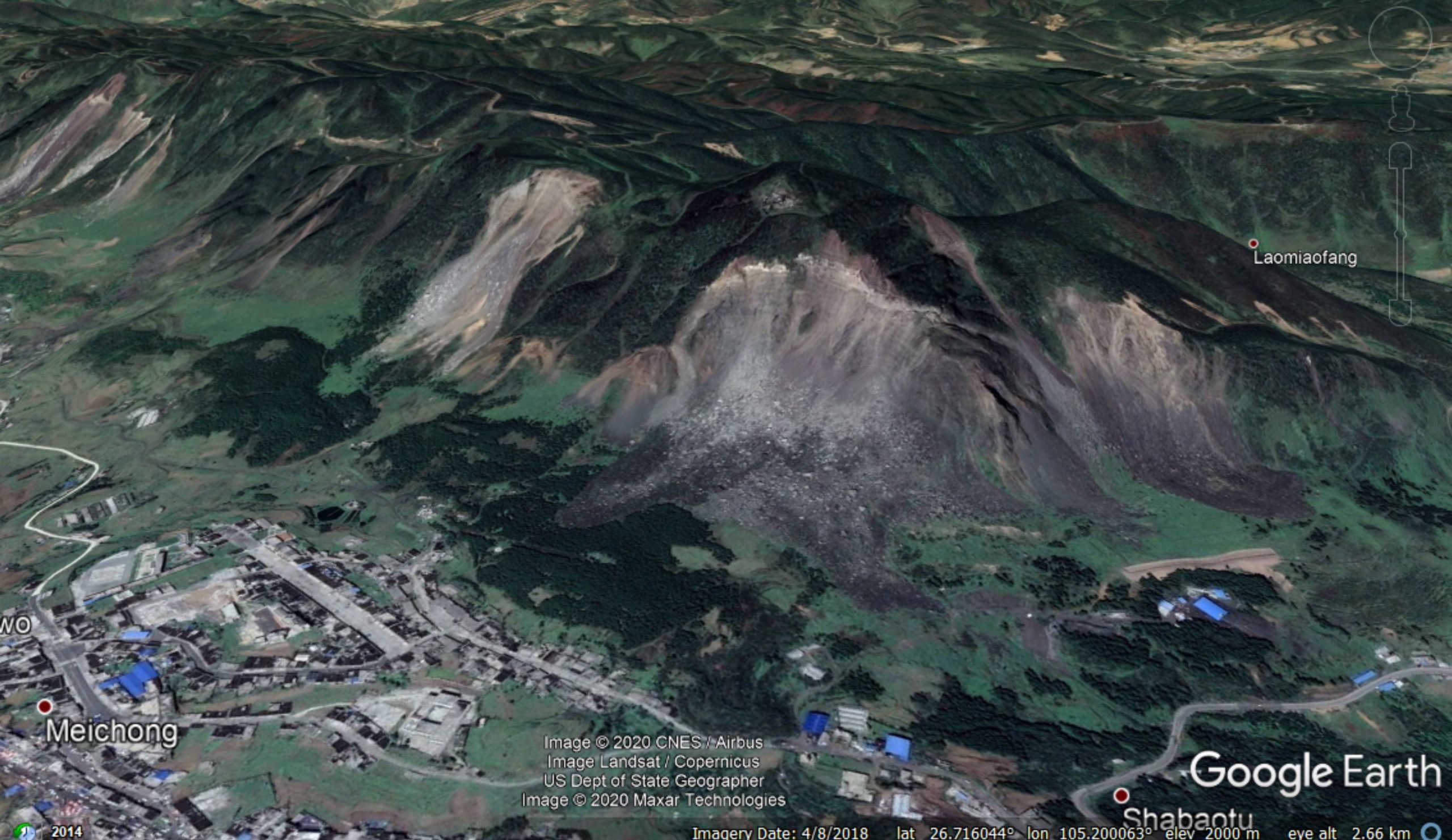
Google Earth image of the landslides at Zongling in Guizhou Province, China.
.
This ridge with multiple landslides consists of interbedded limestones, siltstones and mudstones, with a thick layer of limestone towards the crest of the slope. Wang et al. (2020) note that failure occurs as a result of the collapse of these thick limestone layers, which then induces movement and entrainment of materials below. As the image shows, these collapses have come perilously close to the town.
Whilst one’s eye is drawn to the section of slope in which collapses have already occurred at Zongling, the authors’ attention is on the unfailed portions of the slope. In the paper they demonstrate that there is substantial levels of movement across much of the slope. The InSAR data shows that the slopes creep continuously, but that accelerated periods of deformation occur in periods of heavy rainfall. The graphs below show the movement history of three areas of active deformation, plotted along with the precipitation, which appears to show that more movement occurs in periods of heavier (seasonal) rainfall::-
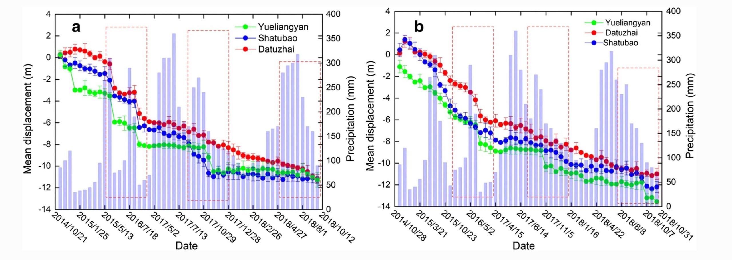
The displacement and precipitation of the slopes at Zongling, from Wang et al. (2020). The graph on the left shows Sentinel-1 ascending data, whilst the one on the right shows Sentinel-1 descending data.
.
I urge caution in interpreting this graph though as something very odd is going on with the time series. The intervals between the x-axis labels are highly non-linear – for example there are four tick marks for data in 2018 and only one for 2016. So on first inspection the data appears to be a linear time series, but is not. I don’t think that data should be presented like this, and I’m surprised it got through the refereeing process in this form, but the episodic movement of the landslides appears to be evident.
But there is another factor in play here too. Wang et al. (2020) describe extensive coal mining in the Zongling area, including extraction over the last 25 years of coal from galleries located directly below the slopes. The InSAR data suggests that there is extensive deformation occurring on the lower portions on the slopes, suggesting that a key factor in these landslides might be disturbance caused by the mining.
Reference
Wang, J., Wang, C., Xie, C. et al. 2020. Monitoring of large-scale landslides in Zongling, Guizhou, China, with improved distributed scatterer interferometric SAR time series methods. Landslides. https://doi.org/10.1007/s10346-020-01407-5.
 Dave Petley is the Vice-Chancellor of the University of Hull in the United Kingdom. His blog provides commentary and analysis of landslide events occurring worldwide, including the landslides themselves, latest research, and conferences and meetings.
Recent Comments