2 April 2020
High resolution Planet Labs imagery of the Luming Mine accident
Posted by Dave Petley
High resolution Planet Labs imagery of the Luming Mine accident
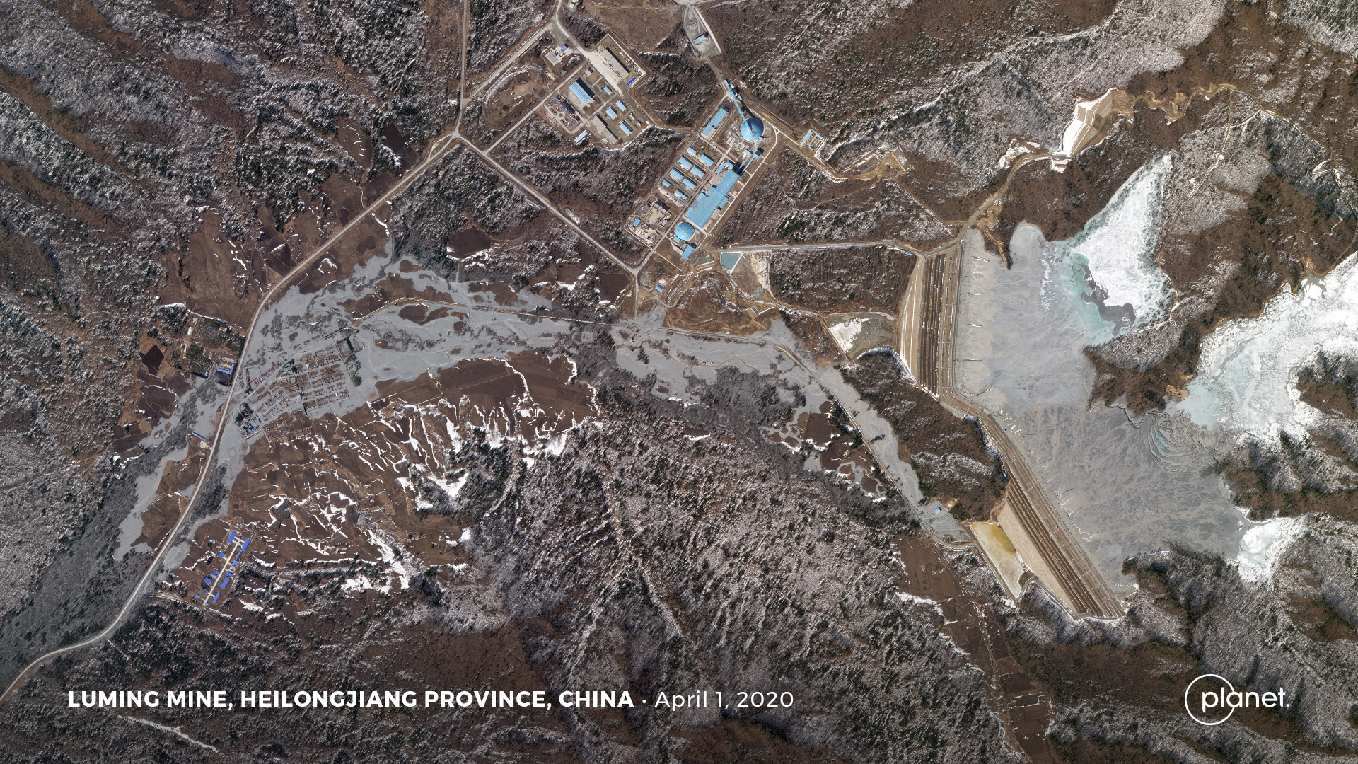
My friends at Planet Labs have successfully captured, and have kindly provided, a high-resolution satellite image of the Luming Mine accident, in which polluted water has escaped from a tailings dam in China. This image was acquired yesterday, 1st April 2020, using the Sky Sat tool. Robert Simmon at Planet Labs very kindly undertook the processing.
This is the image of the Luming Mine accident:-

Planet Labs SkySat image of the aftermath of the Luming Mine accident. Image collected by, and copyright of, Planet Labs on 1 April 2020
.
The image, which is rather beautiful, captures the two tailings dams (but see below), which are intact and the extensive pollution in the valley below the dam. The Planet Labs SkySat instrument is rather magnificent.
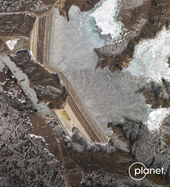
Below is an enlarged version of the image, highlighting the tailings pond and the two dams:-

Planet Labs SkySat image of the aftermath of the Luming Mine accident. Image collected by, and copyright of, Planet Labs on 1 April 2020.
.
So what does this tell us? Well, first, the dams are indeed intact. Second, as pointed out by loyal reader Caner in the comments yesterday, there has been a recent raising of the height of the tailings dams, which has extended across the intact terrain between the two original structures. It appears that this raising has been undertaken by the upstream method, which is now widely considered to be problematic.
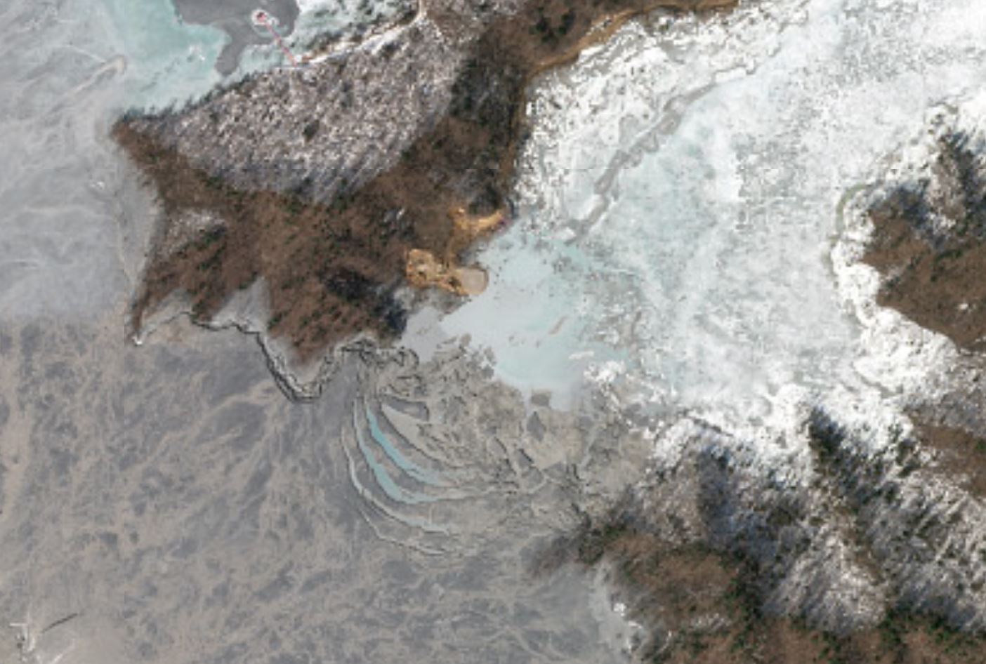
The news reports of the problems suggest that the mine operators are building a road to the location of the problem. I am struggling to see any such construction around the dams themselves. However, there does seem to be a substantive change towards the back of the tailings pond:-

Planet Labs SkySat image of the aftermath of the Luming Mine accident. Image collected by, and copyright of, Planet Labs on 1 April 2020
.
In this area there is clear evidence of work being undertaken and extensive deformation of the tailings including evidence of the formation of a trough and the development of what I would interpret to be tension cracks.
I am no expert on tailings facilities, but has the problem developed at a dewatering well located upstream of the tailings dams? Can those who know more about these facilities comment?
Reference and acknowledgement
Planet Team (2020). Planet Application Program Interface: In Space for Life on Earth. San Francisco, CA. https://www.planet.com/
Many thanks to Robert Simmon of Planet Labs, and to his colleagues there, for tasking the SkySat instrument and for providing the imagery. Their help and support is hugely appreciated.


 Dave Petley is the Vice-Chancellor of the University of Hull in the United Kingdom. His blog provides commentary and analysis of landslide events occurring worldwide, including the landslides themselves, latest research, and conferences and meetings.
Looks like they are trying to build some sort of engineered access pad out onto the tailings near the supposed failure site.The tailings level does indeed appear to be dropping on the south side of the peninsula because a large gully carrying surface runoff into the dropped zone has developed in the tailings to the west of the failure and is building a small delta out into the standing effluent.
Also, If you look approximately 30 degrees to the NW of the new pad, across the peninsula, there appears to be an intact structure of some sort out in the tailings there. It is surrounded by darker gray material. Perhaps this is an active tailings slurry outlet.
At the south dam it looks as though there is water flowing down the southern abutment contact with bedrock. Alternatively if they are using old fashioned decant towers, one of them may have collapsed. Don’t see them on the images .
I’ve spoken with some colleagues and the leading theory at present is the collapse of a decant tower (in the vicinity of the tension cracks that you have noted), resulting in a sinkole and the outflow of tailings. It’s possible the cold climate may have led to the failure.
In the Google Earth image at the hill between the dams, there is what appears to be a small seepage collection area at the toe near the road and the south seepage collection pond, with a pump station with a blue roof.
If you look carefully by the pump station there is a high flow outlet from a portal at the base of the hill into a small pond, a flow volume that seems higher than typical toe seepage collection, with white water turbulence. Then if you look at this area in the post failure images you can see this may be the source for flow, following the grey sandy channel braids back.
It is directly opposite and close by the collapsed area with tensions cracks near the current working repair. Following on Prof. Petley’s comments, I believe this may be the outlet for the so-called standpipe, the inlet of which they are trying to access now.
In the Earth images you can clearly see what looks like a reclaim barge with a red roof in the easternmost pond area and a reclaim line going northeast to a hill portal which I assume exits and follows the access road. I’m thinking perhaps the leaky system wasn’t for supernatant reclaim but for dam foundation drainage, and it piped.
They have a lot of work to fix this, in that case.
Here’s the Earth/Maps link showing the outlet: https://goo.gl/maps/JTkkdEzQMAesp37r8
I was incorrect, it is a reclaim system, not a foundation drain.
You can use Google Earth Pro Windows’ satellite image history you can follow the starter dam construction as well as the standpipe boring.
If you place pins at drill site pads in several locations they track standpipe discharge points in later photo at the shoreline, opposite the portal outlet by the blue pump station. Start with the Aug and Oct 2013 images and there are a chain of drill sites working back East where the pond shore would later be. In one image you can see a drill frame. A Sept 28 2015 image shows standpipe locations along the now flooded shore. One of the standpipes that was at the shore but later drowned seems to be the leak source.
It just seemed odd to me to discharge a bored reclaim line into a sump at the tailings dam toe rather than into a pipeline directly to the mill.
Here is the location: 52 T 467279.99 m E 5243743.41 m N. Sorry can’t figure out how to get a link from Earth Pro that is directly paste-able and the browser based Earth doesn’t have sat image history.
Prof. Petley, if you email me I will send a KMZ with the pins if you like, save you some trouble.
It appears to possibly be some sort of failure of a decant structure. Vertical decants used to be commonly used in tailings design for the convenience of raising them as you raise the dam, but fell out of favor due to many problems and failures of the structures. This might be a good example of that, with tailings flowing out the decant pipe at the toe. That’s only speculative, though, it’s hard to tell the failure mechanism if subsurface structures are involved.
The “delta” of fresh deposition to the northwest is likely where they are discharging material from the emergency dredging mentioned in the text.