
21 April 2020
The most expensive landslide samples of all time? Moon rock
The most expensive landslide samples of all time? Moon rock
The EOPortal website has a nice article about work underway to open and re-analyse two samples of moon rock, recovered by the 1972 Apollo 17 mission and safely stored thereafter by NASA. Since the mission analytical capabilities have vastly improved; these samples were wisely preserved for future generations anticipating that this would occur. NASA has decided that now is the time to take another look.
The samples in question, 73002 and 73001, are part of a c.70 cm core of regolith collected near Lara Crater within the narrow Taurus-Littrow Valley on the moon. This site is geologically very interesting. As EOPortal puts it:
The Apollo 17 landing site lies within the narrow Taurus-Littrow Valley, surrounded by several steep mountains including the North and South Massifs, with a fault scarp, caused by a difference in elevation between the two sides of the fault, cutting across the entire region.
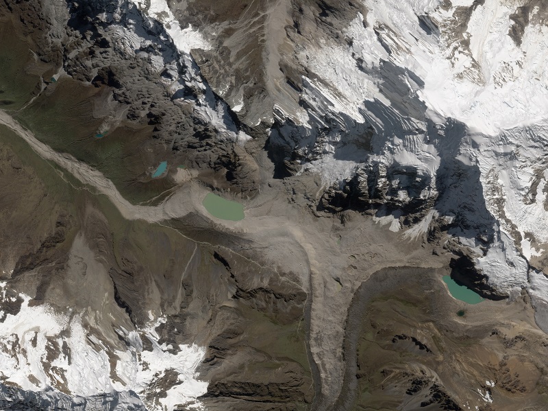
The floor of the valley consists of lava and ejecta from impact events. The valley is depicted in this image, which I have annotated to show the key features:-
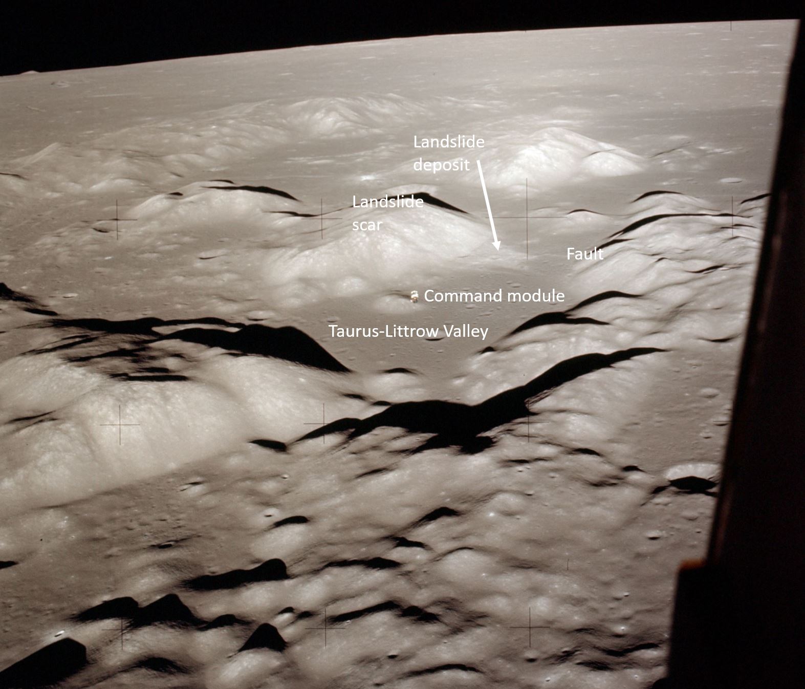
Annotated image showing the landslide on the moon sampled by the astronauts on Apollo 17. This is Hasselblad photograph taken from the LM Challenger as it passed over the Taurus-Littrow Valley. Image AS17-147-22464 [NASA].
As the image shows, the sample was collected from a landslide deposit on the moon, the origin of which was the massif shouwn in the image above. There were good reasons for sampling a landslide – it provided access to deposits that originated on the hillside above, which was inaccessible to the astronauts, giving the geologists a better opportunity to understand the lunar geology.
A part of the aim of re-analysing these samples is to try to better understand this landslide. For example, a key issue is whether the landslide was triggered by an impact event, by movement of the fault or by another process.
The cost of the Apollo missions to the moon is believed to have been $25.4 billion, which was about $200 billion in a modern-day equivalent. These are two extremely expensive landslide samples. Understanding planetary landslides is a very interesting aspect of the science of mass movements; it will be fascinating to see what these studies reveal.
20 April 2020
Salkantay – what happened after the initial failure?
Salkantay – what happened after the initial failure?
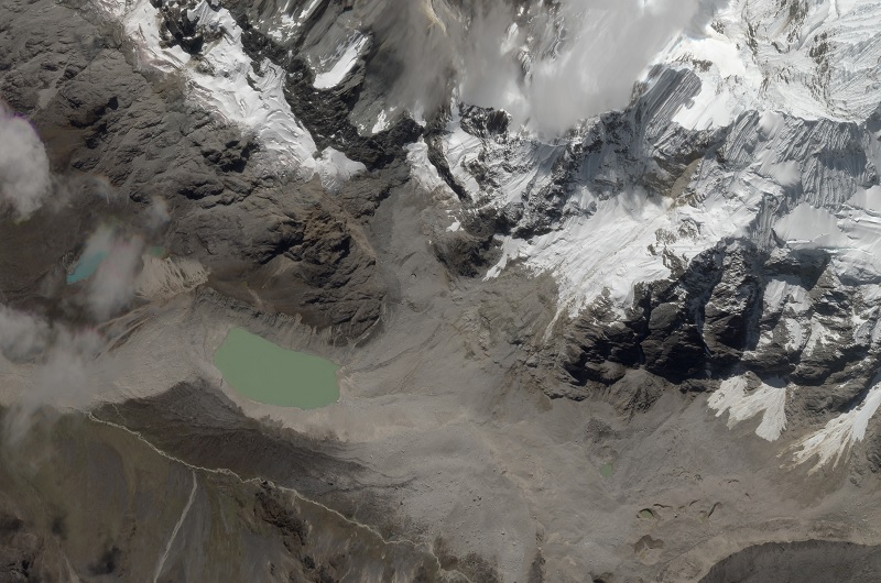
The gorgeous Planet Labs images of the site of the Salkantay landslide in Peru provide considerable insight into the post-failure processes, and suggest that the landslide behaved in ways that I find quite surprising.
The image below shows the foot of the slope, Salkantay Cocha Lake and the initial part of the track:-
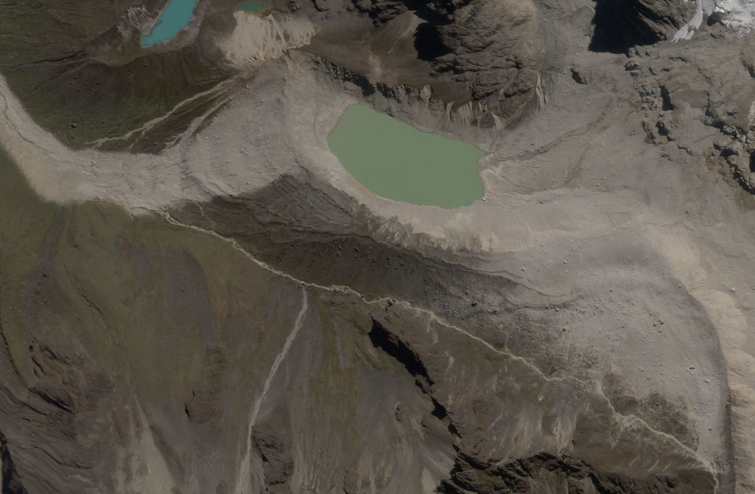
A high-resolution SkySat satellite image of the area at the foot of the Salkantay landslide by Planet Labs. Image captured on 14 April 2020, copyright Planet Labs, used with permission.
.
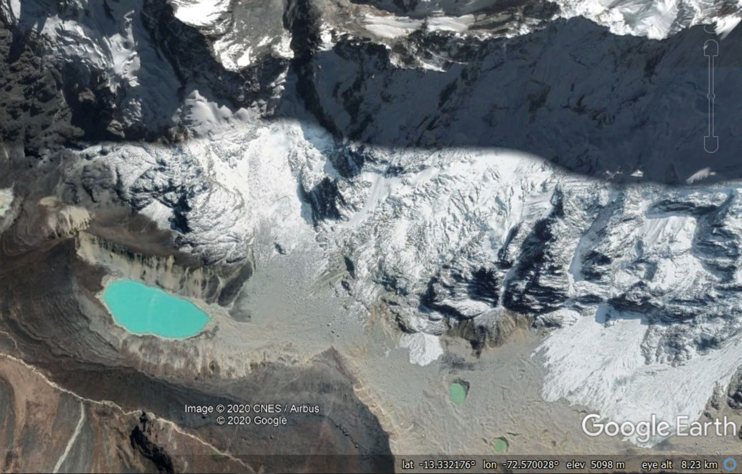
It is worth comparing this with the Google Earth image of the same area, collected in September 2019:
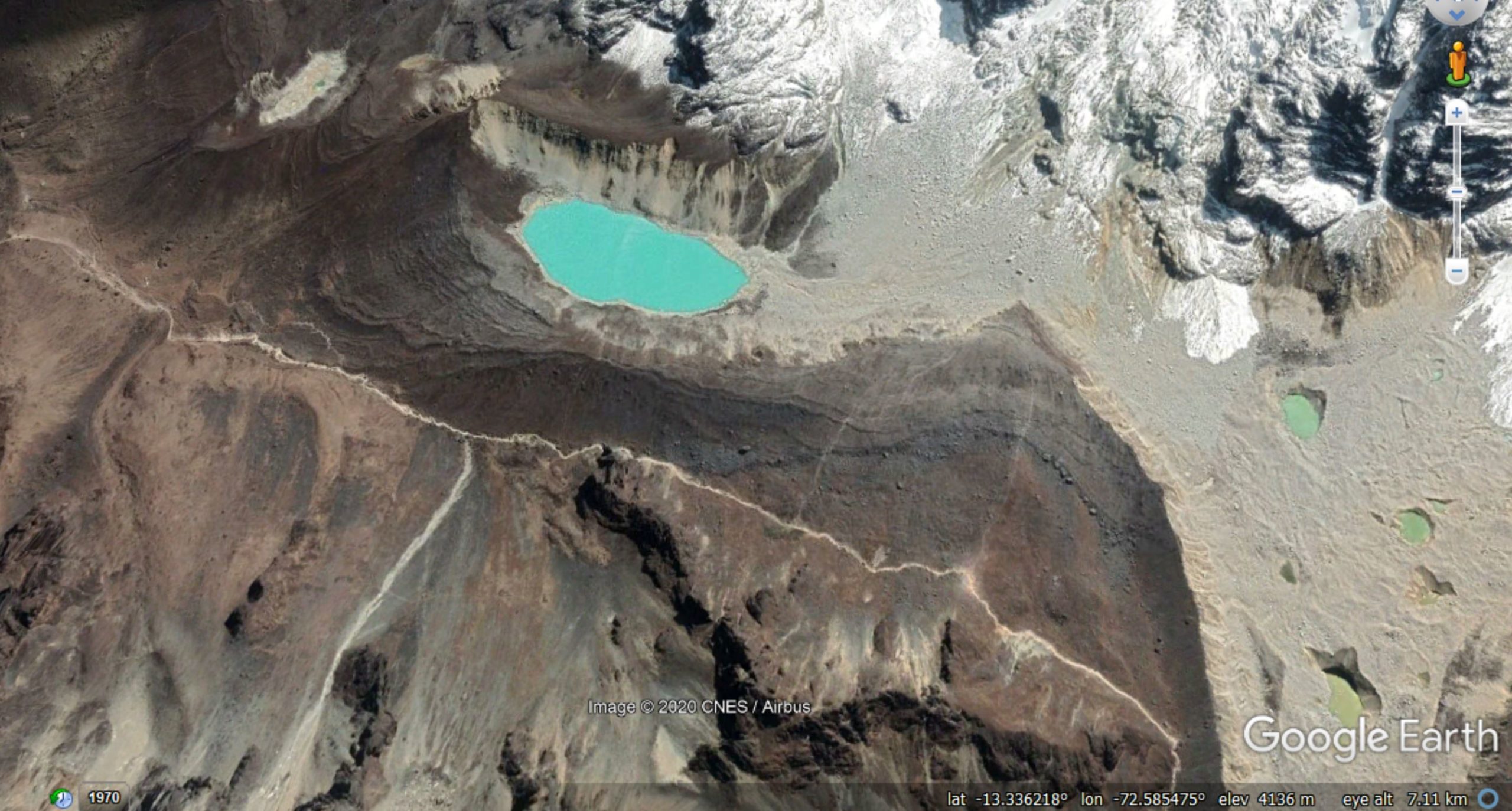
Google Earth image of the foot of the slope affected by the Salkantay landslide
.
Starting at the southeast corner, there is a new landslide deposit between the track/path and the moraine ridge. This deposit is mostly fine-grained but with some large boulders present too. The moraine ridge has been smoothed by the passage of the landslide. There are two possible interpretations for this. Perhaps landslide has spread laterally after failure. This is possible but feel slightly counter-intuitive as the large boulders will have had to have undergone a major change in trajectory? Or perhaps there was also a failure on the slope orientated roughly north-south above the lake, which is in line with this deposit?
Any views?
The main part of the landslide has traveled almost due west into Salkantay Cocha Lake (this is sometimes termed Humantay Lake). The path that it took as it entered the depression, and the path it took as it left, are both clear. The intriguing aspect is that the amount of water in the lake appears to be essentially unchanged. This implies that the landslide skimmed across the surface of the lake without disturbing it. I find this really surprising. The alternative explanation, that the lake refilled after passage of the landslide, seems unlikely as there is no obvious source for this amount of water. The water was present in the lake on 10 March, and reports immediately after the landslide also indicated that water was present.
This is very perplexing behaviour.
The track of the landslide after leaving the Salkantay Cocha Lake is also clearly shown in the imagery. The southern margins of the track appear to me to be indicative of dust deposition:-

A high resolution SkySat satellite image of part of the track of the Salkantay landslide by Planet Labs. Image captured on 14 April 2020, copyright Planet Labs, used with permission.
.
The implication is, I think, that this portion of the flow was mostly dry – i.e. it was a rock avalanche at this point, not a debris flow. The videos much further down the valley appear to show a much wetter flow, which I think implies that the landslide entrained substantial amounts of of water (and probably wet sediment) as it traveled downstream.
These Planet Labs SkySat images are a remarkable resource for understanding this complex landslide. Your thoughts on my interpretations are very welcome.
Reference and acknowledgement
Planet Team (2020). Planet Application Program Interface: In Space for Life on Earth. San Francisco, CA. https://www.planet.com/
Many thanks to Robert Simmon of Planet Labs, and to his colleagues there, for tasking the SkySat instrument and for providing the imagery. Their help and support is hugely appreciated.
17 April 2020
The Salkantay landslide: wonderful Planet Labs high resolution satellite images
The Salkantay landslide: wonderful Planet Labs high-resolution satellite images
Back in February I wrote a series of pieces reconstructing the events that led to the huge and highly destructive debris flow in the Salkantay region of Peru. It is clear that this event was a large landslide from the mountainside that transitioned into the debris flow. My friends at Planet Labs have now succeeded in capturing not one but two fantastic high-resolution images of the site of the initial landslide. The first was captured on 11 April 2020 using the SkySat instrument:-
A high resolution SkySat satellite image of the the Salkantay landslide by Planet Labs. Image captured on 11 April 2020, copyright Planet Labs, used with permission.
.
The second was captured on 13 April 2020, also using the SkySat instrument:-
A high resolution SkySat satellite image of the the Salkantay landslide by Planet Labs. Image captured on 14 April 2020, copyright Planet Labs, used with permission.
.
Let’s take a closer look at the source of the landslide. An image captured by Benito Moncado of the site shortly after the landslide suggests that the initial failure was a steep wedge high in the rock mass. This is a more detailed view of the landslide scar and the initial downslope deposit:-
Detail from the high resolution SkySat satellite image of the the Salkantay landslide by Planet Labs. Image captured on 11 April 2020, copyright Planet Labs, used with permission.
.
It is worth comparing this image with the pre-failure Google Earth image of the Salkantay site:-
A Google Earth image of the site of the Salkantay landslide
.
Comparison of the two images shows a long section of rock slope that has been removed by the landslide. Interestingly, the 11 April image shows a smaller (but not insignificant) fresh landslide scar near to the crown of the landslide, and a debris trail on the snow, suggesting that some instability is still occurring. The main (February) landslide has planed off the topography down the slope, probably indicating sliding on a joint surface. It is worth noting that this slope is much steeper than it might appear on the satellite image (take a look at the photographs of the site in my earlier post).
I think that the behaviour of the landslide at the foot of the slope is really interesting too, but that is a matter for a future post.
Reference and acknowledgement
Planet Team (2020). Planet Application Program Interface: In Space for Life on Earth. San Francisco, CA. https://www.planet.com/
Many thanks to Robert Simmon of Planet Labs, and to his colleagues there, for tasking the SkySat instrument and for providing the imagery. Their help and support is hugely appreciated.
16 April 2020
The collapse of the Dehdasht-Pataveh tunnel portal in Iran
The collapse of the Dehdasht – Pataveh tunnel portal in Iran
There are two very interesting landslide videos available this week. One is contained in a Tweet by @GeotechTips showing a rather splendid slump in what appears to be residual soil. The location and circumstances of this failure are not clear to me. Does anyone have any further information?
https://twitter.com/GeotechTips/status/1250045392047095808?s=20
.
Perhaps the most interesting aspect of this video is the manner in which the toe of the punches up, deforming the pavement of the road. The motorcyclist is rather lucky, aided by a well-timed swerve and bail out. The motorbike itself appears to be buried at the end of the video.
Viewed after the event, the deposit of this landslide might give one the impression that it had been quite a benign process. The video shows the violence of even quite small landslides.
The other video is the collapse of the Dehdasht – Pataveh tunnel portal in Iran, which occurred on 9 April 2020. This video has been posted to Youtube. The video shows a tunnel portal undergo a large-scale rock mass failure:-
.
Others will be able to comment on the construction method at this site, but it seems surprising to me that a situation can arise in which these two large rock columns can be undermined without additional support being put in place. It would seem to have been at high risk of a toppling failure due to the very clear vertical fractures that permitted the detachment of the two large rock blocks:-
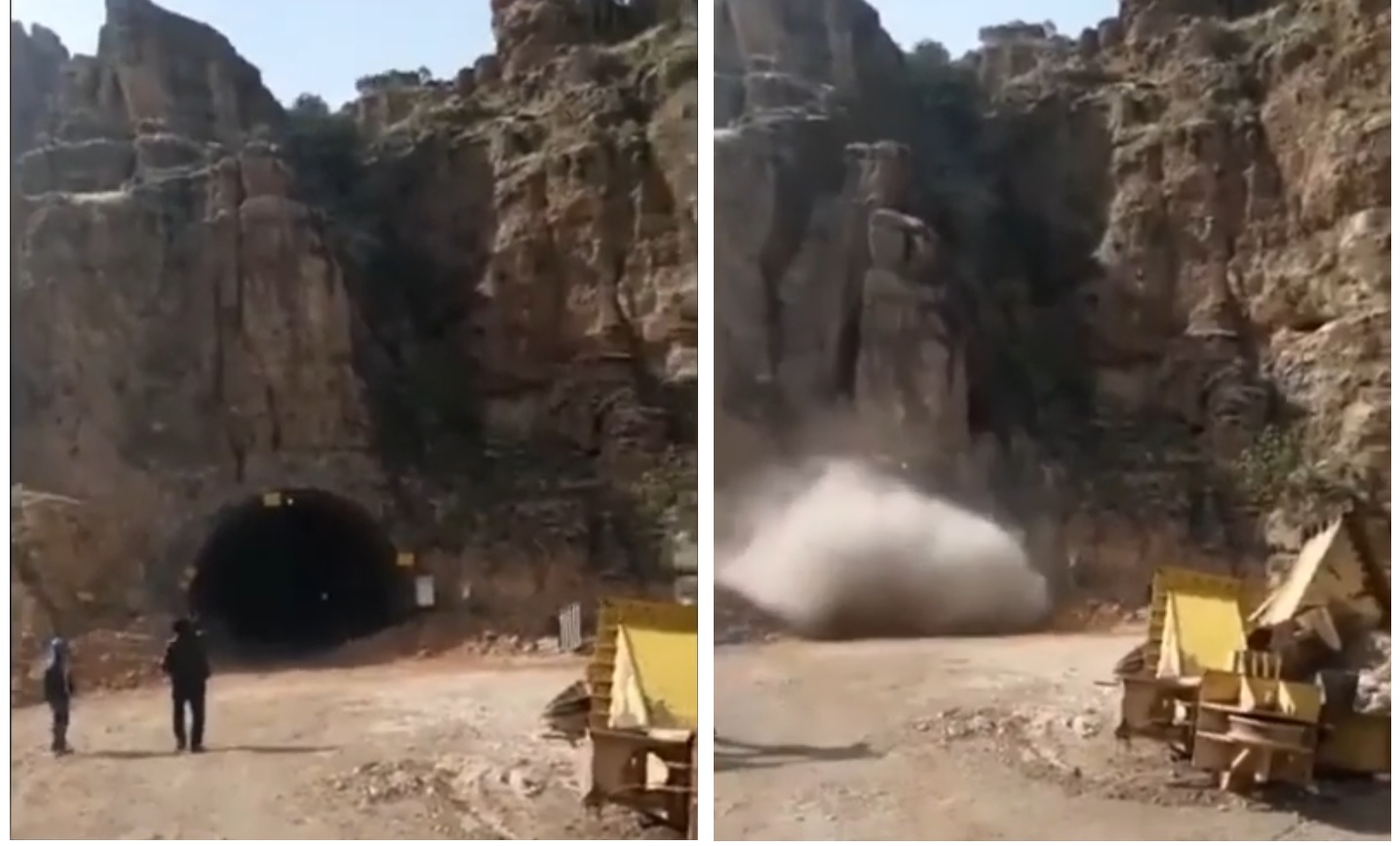
The collapse of Dehdasht – Pataveh tunnel portal in Iran. Stills from a video posted to Youtube.
.
According to the text that accompanies the video, “the Dehdasht – Pataveh tunnel which is under construction of the IRGC Khatam-al Anbia Construction collapsed on April 9. The project was started back in 1994 and was supposed to be completed in 2004.”
I have no way to verify this information.
15 April 2020
Kegesuglo: a deadly landslide in Papua New Guinea on Friday 10 April 2020
Kegesuglo: a deadly landslide in Papua New Guinea on Friday 10 April 2020
On Friday 10 April 2020 a large landslide was triggered, probably by rainfall at Kegesuglo in Kundiawa-Gembog district in Papua New Guinea. The location of this landslide appears to be -5.833, 145.1. This is a remote, hilly location at the foot of Mount Wilhelm, the highest mountain in Papua New Guinea. It’s worth noting that in some reports the village is named Keglsugl.
The Watchers has a report about the impact of the landslide:-
A major landslide hit the Kegesuglo area in the district of Kundiawa-Gembogl, Papua New Guinea, on Friday, April 10, 2020, resulting in at least 10 fatalities and widespread damage. Eight of the bodies were retrieved over the weekend, while the last two were recovered on Monday, April 13.
Homes, gardens, livestock and fish farms in the village of Duanigle Gowe were destroyed. According to Sieland Hermann Banda, a physiotherapist with the Kundiawa General Hospital, the landslide took place near the Mount Wilhelm Secondary School.
“Two of the houses of the staff of the Mount Wilhelm Secondary School were affected. One of them is a senior teacher who has taught for more than 30 years here at Mt Wilhelm Secondary School, and he is dead with three kids and left the wife with the other two kids,” Banda explained.
The same article includes this image of the landslide, which gives an impression of the scale:-

The aftermath of the landslide at Kegesuglo in Papua New Guinea on 10 April 2020. Image from The Watchers, taken by Sieland Hermann Banda
.
Collecting satellite imagery in Papua New Guinea is very challenging because the skies are so often covered in cloud, by Planet Labs did succeed in acquiring an image of the landslide on 11 April 2020, the day after the landslide:-
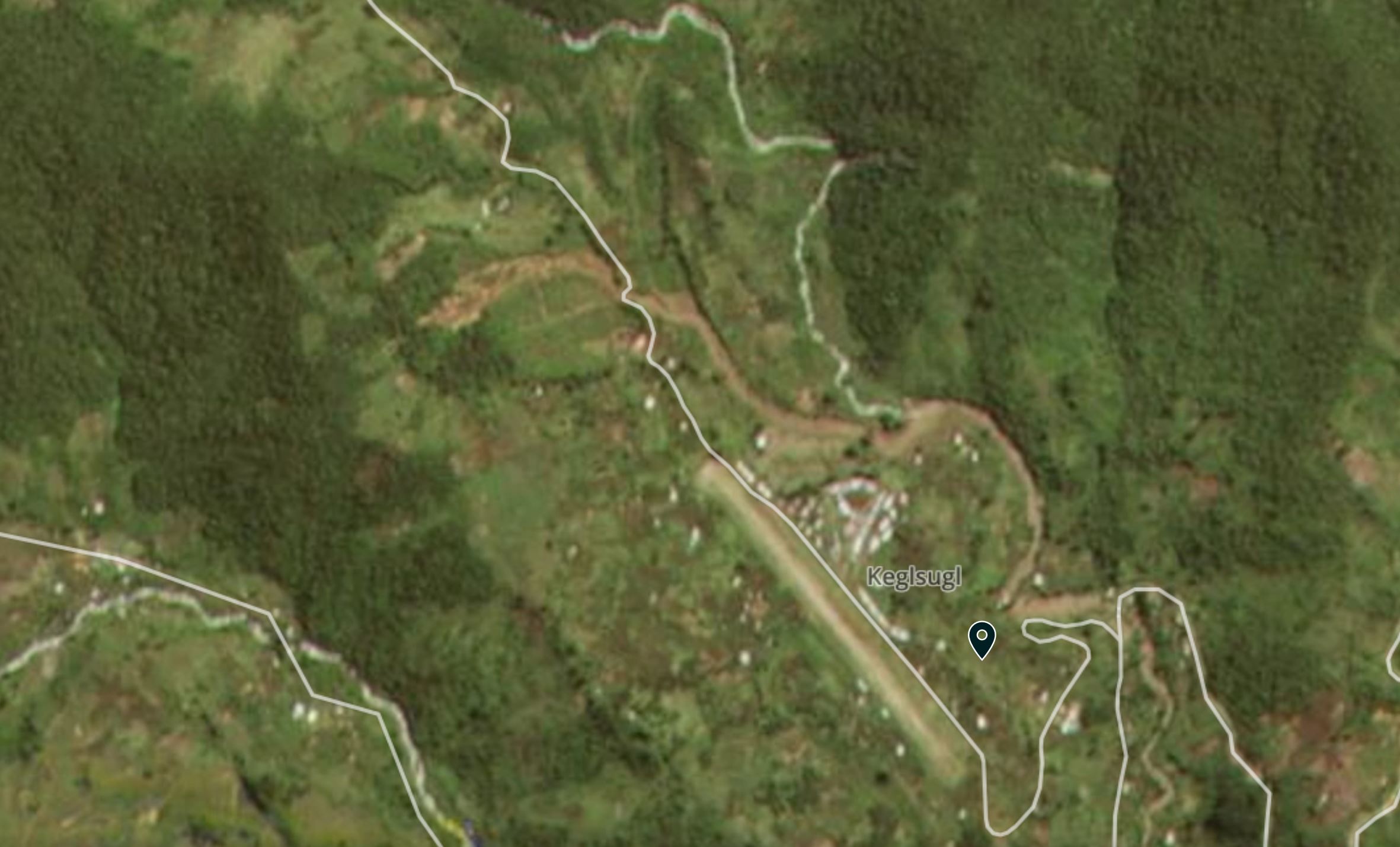
A Planet Labs image of the Kegesuglo landslide in Papua New Guinea. Image acquired on 11 April 2020, copyright Planet Labs, used with permission.
.
This is a landslide that appears to have had quite high mobility (the runout distance is about 2 km), probably because it has channelised.
Reference and acknowledgement
Planet Team (2020). Planet Application Program Interface: In Space for Life on Earth. San Francisco, CA. https://www.planet.com/
8 April 2020
Denali Park Road: fascinating landslides in a subarctic mountain environment
Denali Park Road: fascinating landslides in a subarctic mountain environment
Back in January, an article in the Anchorage Daily News highlighted landslides on Denali Park Road, a high latitude highway through Denali National Park in Alaska. This was based on a paper presented at the 2019 AGU Fall Meeting in San Francisco by Zena Robert, a graduate student at the University of Alaska Fairbanks. Zena reports on work by National Park staff that has identified over 150 landslides along the 150 km length of the road, many of which are really fascinating. For example, accompanying the article is this image, taken by Zena, of a large-scale slope failure:-
A large landslide on Landslide on Denali Park Road in Alaska. Image by Zena Robert via Alaska Daily News.
.
This is a broadly similar to an active layer detachment slide, and has probably occurred because of summer melting of permafrost, which generates water-saturated, weak materials that are then able to slip on the steep slopes. Note the interesting landslide deposit, also the potential for instability lower on the slope and at the landslide crown.
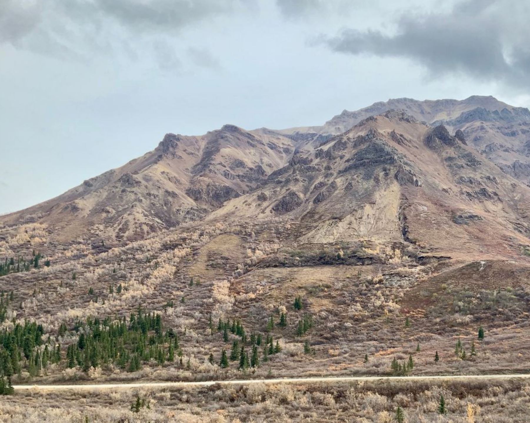
A further landslide that she highlighted on Denali Park Road is at the Pretty Rocks area on the pass adjacent to Ploychrome Mountain (63.537, -149.815 if you wish to take a look). This landslide is pretty easy to identify on the Google Earth imagery:-
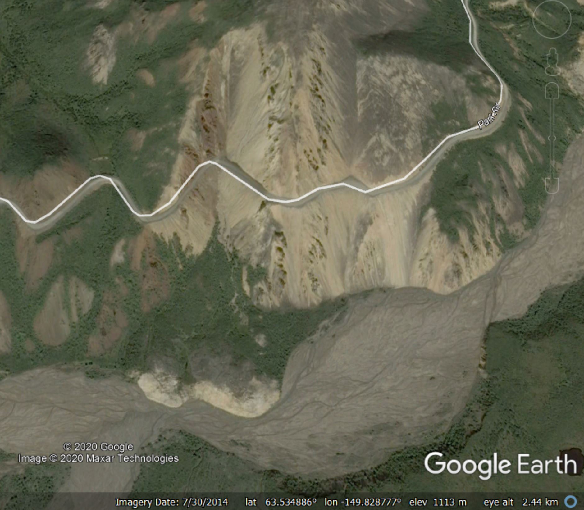
Google Earth image of the landslide at Pretty Rocks in Denali National Park
.
The National Park Service are actively monitoring this landslide. Their records suggest that this landslide reactivated in 2004, moving at a rate of about 60 cm per year. The rate of movement has increased, and at times in 2019 in was moving at a rate of about 50 mm per day.
Of course this road is inaccessible in the winter because of snow. It will be fascinating to see how the slide has progressed when the road reopens for the summer season. As no alternative route is immediately available, the National Park Service have committed to keeping the road open this year.
[NB I have made some minor edits to this post since it was uploaded to improve accuracy].
7 April 2020
Landslides in Art Part 32: The Jungle Book
Landslides in Art Part 32: The Jungle Book
This is the most recent update on my occasional (but long running) series of posts on the depiction of landslides in art. The previous edition featured the works of Leonardo da Vinci; this time, I’m covering something rather more contemporary. And thanks to my friend Sarah for highlighting this depiction of a landslide.
In the Walt Disney film The Jungle Book, released in 2016, Mowgli gets caught in a landslide during a heavy rainstorm. There’s a Youtube video of this portion of the film:-
.
In this section of the film, Mowgli is trekking through the storm on the back of a water buffalo. He becomes aware that the steep slope that they are traversing has become unstable, initially ahead of him and then directly above, and dives off the edge of the cliff into the water. The animation captures the initiation of the landslide and its development:-

The landslide scene from the 2016 Walt Disney film The Jungle Book. Still from a Youtube video.
.
It seems to me that the special effects people at Walt Disney Pictures probably spent some time watching the various Youtube videos of landslides as the animation of the landslide in The Jungle Book itself is pretty good. The failure starts high on the slope, and the animation captures both the accelerating and increasingly chaotic motion of the failure, and the ways in which destabilisation of one part of the slope can lead to instability developing elsewhere. The depiction of trees being toppled is also good.
When the landslide reaches the water the depiction even includes the generation of a small displacement wave:-
The development of the displacement wave at the end of the landslide scene from the 2016 Walt Disney film The Jungle Book. Still from a Youtube video.
.
In my view this is where the simulation of the landslide is at its weakest. There seems to be a mismatch between the scale of the slide on the slope and the volume of material that reaches the water, and the wave seems too small for this event, given the volume of material moving and the steepness of the slope. However, I think we can forgive some artistic licence here – a larger wave would have been quite a problem for Mowgli and the water buffalo.
6 April 2020
The perils of rapid off-site resettlement of people affected by disasters
The perils of rapid off-site resettlement of people affected by disasters
A very frequent frustration in the aftermath of large disasters is the slow rate of reconstruction. There is lots of evidence that camps for displaced people are dangerous places, especially for women and children, and can result in long-term negative consequences for their populations. Thus, there is often substantial pressure to rebuild quickly.
For landslides, rebuilding in situ is often problematic. Unfortunately locations that have been affected by very large slope failures can be vulnerable to repeat events, meaning that relocation of the population is often necessary.
The most extreme version of that in my experience was the relocation of the town of Beichuan in the aftermath of the 2008 Wenchuan earthquake. Beichuan was destroyed, primarily by two giant landslides, rendering the town uninhabitable:-
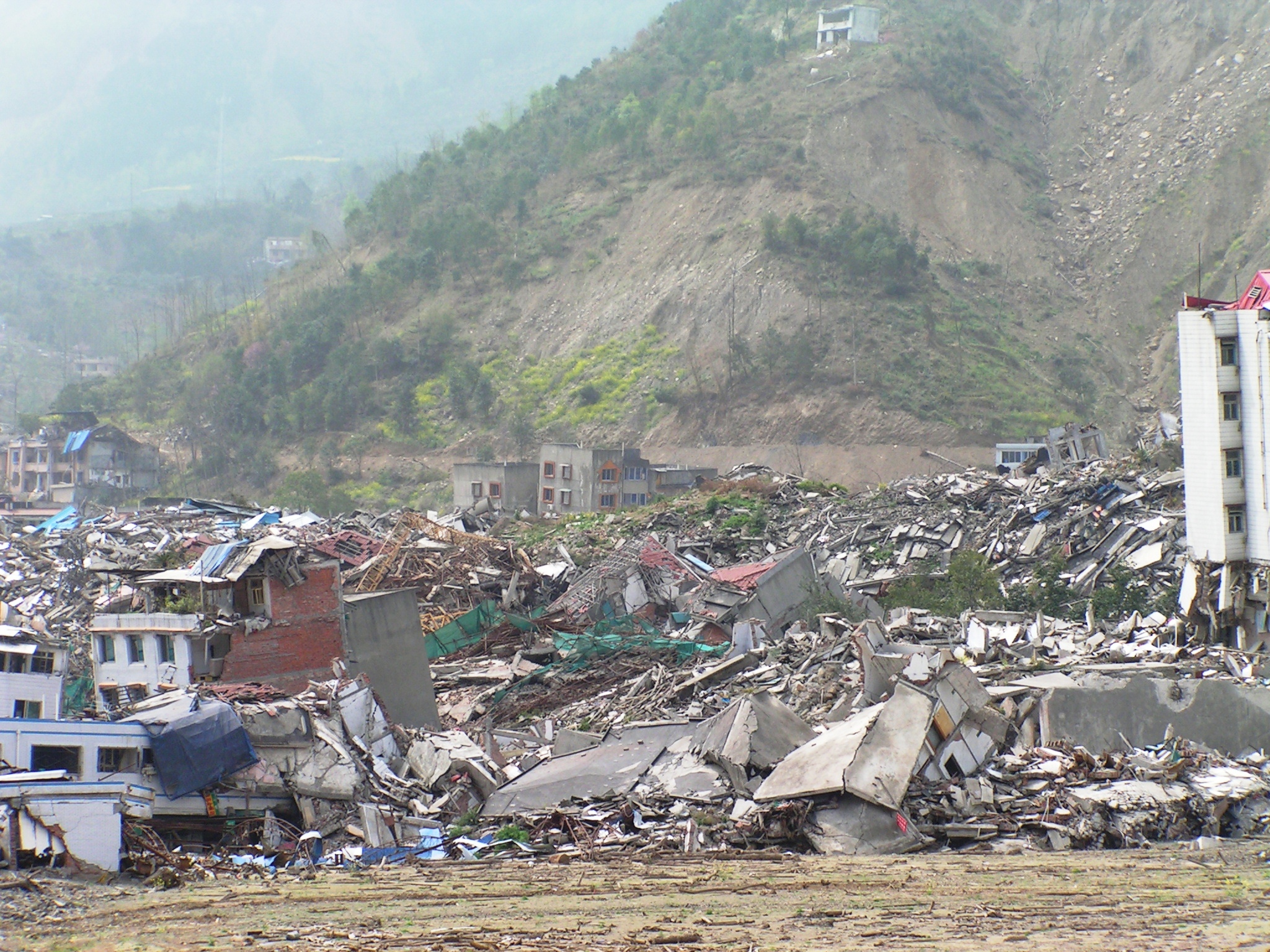
The aftermath of one of the landslides in Beichuan. The population was resettled to New Beichuan, about 23 km away.
.
Within three years of the earthquake the population of Beichuan was relocated to New Beichuan, a completely new town built on the plains some 23 km from the original site. The new town is, on the face of it, remarkable:-
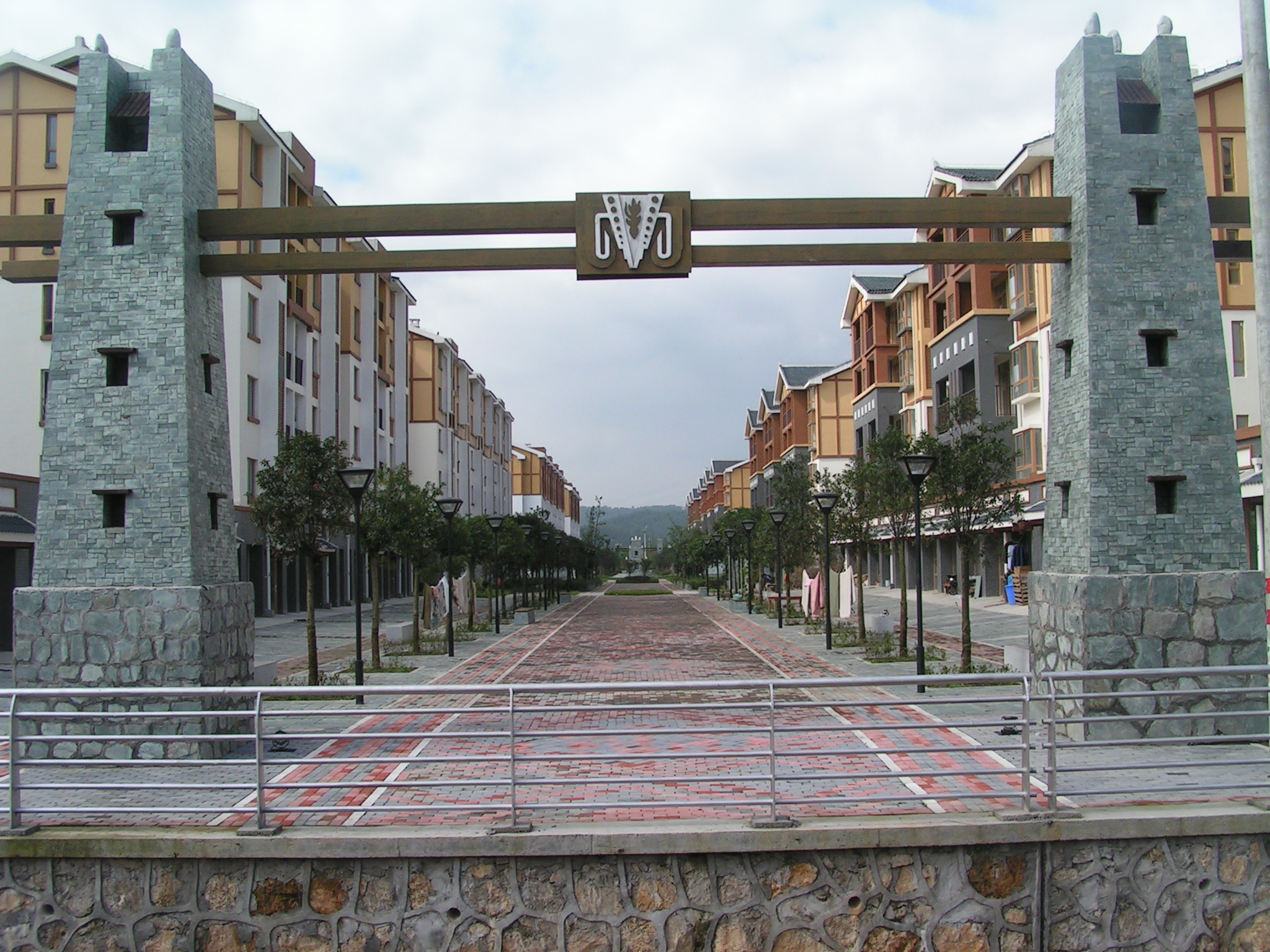
The location of the resettlement of the population- New Beichuan. I took this picture in 2010, before the residents had moved in.
.
A paper recently published in Natural Hazards (Zhang et al. 2019), and available open access, examines the impacts of this relocation on the population. Through surveys it looks at two different groups. First, there is the population of Beichuan itself, but second there is the population of the villages located at the site of new Beichuan, who were forcibly relocated to make way for the new town.
The results are not positive. The authors recognise that the remarkably fast build and resettlement of the population did solve the practical problems of the displacement from the town, and that in doing so it provided for the essential needs of the population – shelter, education, medical services, food, etc. But in doing so it created a series of really significant problems. These can be summarised as follows:
- Problems with the quality of the housing;
- Management and security concerns;
- A disconnect between the ways that the houses, and the town, had been laid out and the ways that the population live their lives;
- A failure to understand that the two groups subject to resettlement had different needs;
- A failure to provide employment and other opportunities for the relocated populations.
Zhang et al. (2019) look in some detail as to the reasons for these problems. The conclude that the major problems were:
- Site selection. Choosing a new site distant from Beichuan and in a very different landscape caused numerous problems for the population subjected to resettlement;
- Inadequate thought went into the spatial layout of the New Beichuan, and into the design and construction of the houses;
- There was too little provision for the economic development of the two (primarily focused on jobs for the people);
- And perhaps most importantly of all, participation of the population subject to resettlement was very inadequate.
The construction of New Beichuan is, on the face of it, the exemplar for the support of a population ravaged by a disaster. But if reconstruction is undertaken too fast without consulting with, and involving, those who have been affected then the outcome may not be all that was intended.
Reference
Zhang, Y., Yu, Y., Xu, W. et al. 2019. Differentiation and integration: off-site resettlement planning practice in New Beichuan after 5.12 Wenchuan Earthquake. Natural Hazards. https://doi.org/10.1007/s11069-019-03649-6
5 April 2020
The 1935 colliery landslide in Cwmaman, South Wales
The 1935 colliery landslide in Cwmaman, South Wales
A week ago I posted about a tragic landslide accident in Japan, as recorded in archive footage collected by British Pathe and now available online. There are some very interesting landslide reports in that archive; one in particular caught my eye. There is a short news report about a landslide affecting the village of Cwmaman in South Wales. The news recording is dated 28 February 1935, although the landslide actually occurred on 22 February 1935.
The footage reports that as a result of recent rainfall thousands of tonnes of earth and slag slid from the side of the mountain. The image below, from the film, shows the landslide debris:-
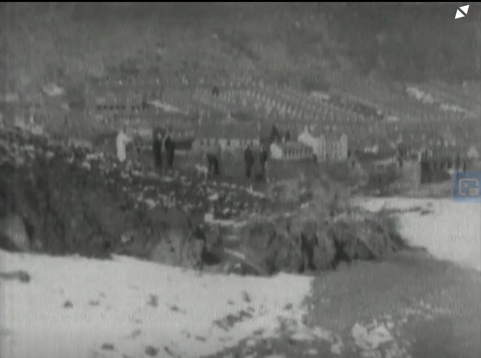
The 1935 colliery landslide in Cwmaman, South Wales. Still from a British Pathe news film dated 28 February 1935.
.
The the landslide came remarkably close to the village is not in dispute. The image below shows another still from the news report. The landslide debris appears to be directly adjacent to the end house in the terrace:-

The aftemath of 1935 colliery landslide in Cwmaman, South Wales. Still from a British Pathe news film dated 28 February 1935.
.
Clearly this was a very serious incident. The interesting aspect is that it was not discussed in the tribunal report from the Aberfan landslide, which did examine other near-miss major colliery landslides in South Wales. The landslide, called the Fforchaman 1935 slide, is briefly discussed in Siddle et al. (1996).
Interestingly, this spoil tip became unstable again in September 1973 – there’s a detailed review of that event on Wales Online. Spoil reached the houses once more, and the report indicates that this was yet another near-miss. In that case a decision was taken to evacuate permanently a row of houses on the edge of the village. The houses were bulldozed a few years later.
This event is another illustration of the remarkable sequence of spoil tip landslides that occurred in South Wales, of which Aberfan was the most serious. The Coal Authority is now undertaking a major review of all spoil tips in South Wales, following the Tylorstown landslide in February. In the words of the highly esteemed landslide expert, Professor Eddie Bromhead (from the same article):
“Right now, you must expect some of the country’s older tips to slide down the hill and valley sides below them if storms like Dennis become increasingly the norm. Even those spoil heaps engineered to cope with surface water flows, for instance, are now at risk. None of them have been designed to retain stability in the kind of extreme weather we’ve been experiencing this winter.”
Reference
Siddle, H.J., Wright, M.D. and Hutchinson, J.N. 1996. Rapid failures of colliery spoil heaps in the South Wales Coalfield. Quarterly Journal of Engineering Geology and Hydrogeology, 29 (2): 103–132. https://doi.org/10.1144/GSL.QJEGH.1996.029.P2.02
4 April 2020
Debris flows after wildfires – an example from the Milli Fire in Oregon
Debris flows after wildfires – an example from the Milli Fire in Oregon
It is well established that debris flows can be a major hazard in the aftermath of wildfires. There are numerous examples, but perhaps the best known are the 2018 Montecito debris flows in California, which killed 23 people in 2018. As wildfire frequency and intensity increases as a result of global heating, understanding this phenomenon better is important.
There is a very nice case study just published in the journal Landslides (Wall et al. 2020) examining a large-scale debris flow after the Milli Fire in Oregon. This was a large fire – it burnt about 97 km² of forest in the Oregon Cascade Range in 2017. The fire was initiated by a lightning strike on 11 August 2017 and the fire was not fully contained until 24 September. In the aftermath of the fire, the USGS highlighted that there was a significant risk of debris flows in the fire burnt area:-
.
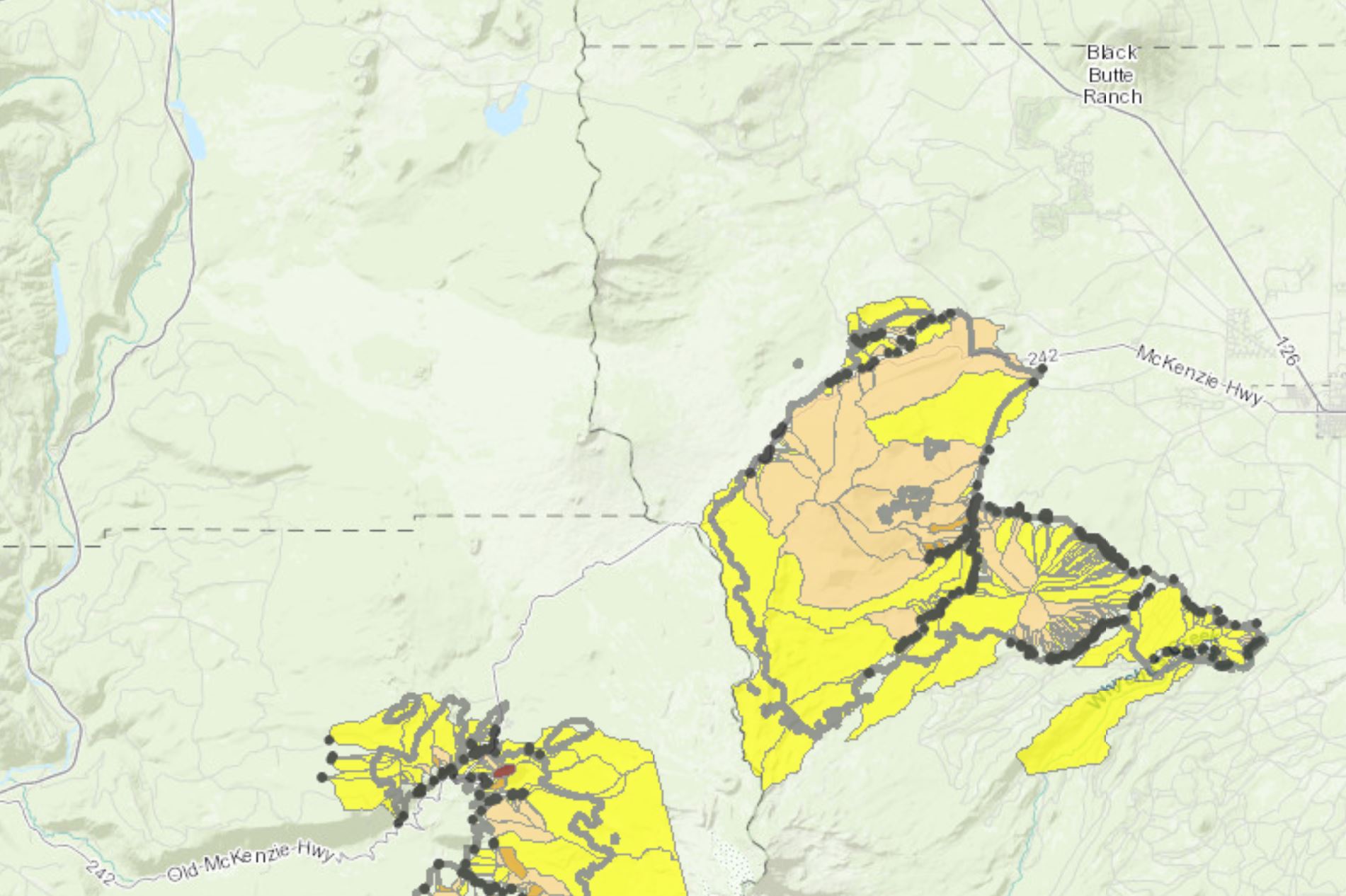
On 20 June 2018 the burnt area suffered significant rainfall. A debris flow initiated on the flanks of Black Crater, traveling 1.5 km. In the paper, the authors provide the following maps that show the scale of the debris flow, the topography over which it traveled and the degree of burn in the Milli Fire:-
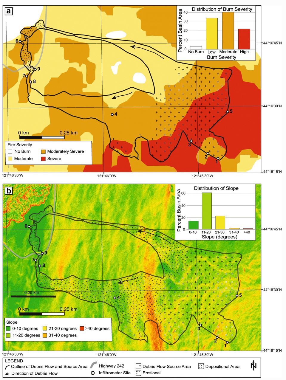
Maps of the Milli Fire debris flow from Wall et al. (2020).
.
As the first map shows, much of the debris flow source area was severely burnt in the Milli Fire. The authors note that by summer 2018 very little revegetation had occurred. The authors measured the infiltration capacity of the soil – the mean value was 23.6 mm per hour. During the storm, local rain gauges measured a peak rainfall rate of 27.9 mm per hour. The authors deduce that the excess rainfall generated overland flow that initiated the debris flow.
In the conclusion, Wall et al. (2020) give a stark warning about debris flow risk in the mountainous areas of the NW USA:
As fire seasons lengthen and fire intensity increases across the Pacific Northwest as a result of climate change, this region may become more susceptible to runoff-initiated debris flows.
Sadly, this applies in may other areas as well.
Reference
Wall, S.A., Roering, J.J. & Rengers, F.K. 2020. Runoff-initiated post-fire debris flow Western Cascades, Oregon. Landslides.
 Dave Petley is the Vice-Chancellor of the University of Hull in the United Kingdom. His blog provides commentary and analysis of landslide events occurring worldwide, including the landslides themselves, latest research, and conferences and meetings.
Recent Comments