21 August 2017
Regent landslide in Sierra Leone: the causes of the disaster
Posted by Dave Petley
Regent landslide in Sierra Leone: the causes of the disaster
The latest tally of losses from the Regent landslide in Sierra Leone has been released by the coroner. To date 499 bodies have been recovered, with about 600 people still reported missing. As expected, this is now the worst landslide of the calendar year to date.
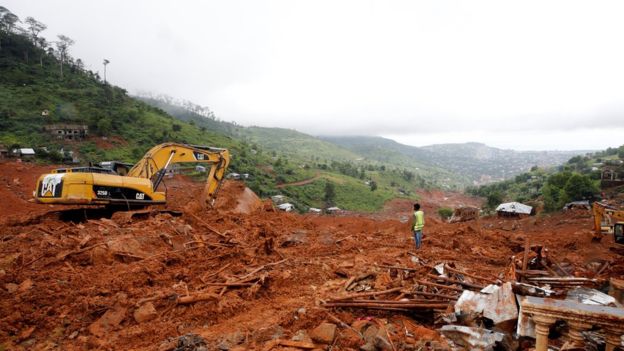
It is increasingly clear that this disaster was caused by a large, but not huge, failure on the bedrock – regolith interface on a slope above the town. This event would undoubtedly have caused mass fatalities, but the true magnitude of the disaster was the result of this failure transitioning to become a high mobility channelised debris flow. This image, from Ultimate FM online, is the most revealing:

The track of the Regent landslide in Sierra Leone, via Ultimate FM online.
.
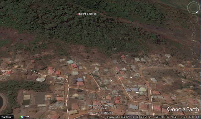
Note the broad landslide track heading downstream from the camera. Given that victims from this disaster have been recovered from the sea, it is likely that this landslide travelled about 6.5 km as the crow flies, probably transitioning into a mudflow en route. The slope that failed is about 300 m long and about 130 m from toe to crest. This is a March 2017 Google Earth image of the slope that failed in the Regent landslide disaster:-

March 2017 Google Earth imagery of the slope that failed in the Regent landslide disaster.
.
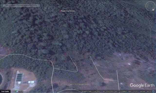
Whilst this slope does show signs of some distress, it is highly unlikely that it could have been identified as being dangerous to this degree from visual imagery alone. Identifying potentially hazardous slopes in such settings remains a major challenge. Of greater interest perhaps is to compare the above image with the first high resolution image available in the Google Earth archive:-

Google Earth imagery from 2005 showing the location of the Regent landslide.
.
The slope has lost some forestry, but the scale of deforestation here is not huge. What is more notable is the change in land use at the toe of the slope. In 2005 this area was mostly unpopulated; immediately prior to the Regent landslide it had dozens of houses. Needless to say it is this growth of urban areas in unsuitable sites that is driving an increase in losses from these events. The combination of this effect with increased rainfall intensities as the climate warms is lethal.


 Dave Petley is the Vice-Chancellor of the University of Hull in the United Kingdom. His blog provides commentary and analysis of landslide events occurring worldwide, including the landslides themselves, latest research, and conferences and meetings.
I am of the opinion that this issue should not just be buried, since on the basis of the havoc created, a close to logical conclusion needs to be drawn through thorough investigation to understand the root cause. I am not very familiar with the nature of the bedrock within the area, thus am limited in the discussion. However, since it is an issue of significant international interest as a result of the loses, we may need to further our investigation to cover the following issues:
1) has there ever been a situation of seismic activity in the area?
2) the hill – was it as a result of historical anthropogenic activity (say mining) in the area?
3) what is the potential maximum flood capacity at Regent? Seems the location from the google map shows a dyke!
Let us help ourselves.
There is many solation this devastating events, must be extensive DRR works, mapping, dedined to risk than reduce the risk togather recovary works but all of this long term and exact works.
But now and emercently must be move to that people to safely place who is undertaken dangerous areas. Produce a social houses. Houses estate , easly smallest and cheapest.
Sierra Leone’s deadly floods and mudslides were ‘a man-made disaster’
Floods and mudslides that left more than 400 people are believed to have been man made. And could have been avoided, according to a leading environmentalist
The human anthropogenic factor could be just one of several factors but like Victor mentioned above further investigation will reveal more answers. The area is generally prone to landslide but for a combination of various factors including but not limited to human activities. Infact there have being two separate recent but non fatal landslide just about 600m from the regent landslide this August. Landslide at a nearby Forest reserve that has little or nothing to do with human activities point out consideration of other factors
As a Sierra Leonean Geologist who have visited the area with SLIG, I can say the area consist of mainly layered Gabbroic rocks which could play a vital role in encouraging fractures and faults .