
28 October 2021
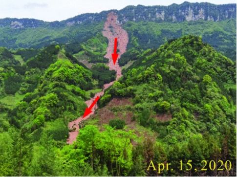
The 21 July 2020 Shaziba landslide at Mazhe Village in Enshi, China
The 21 July 2020 Mazhe Village landslide in Enshi, China
Back in July 2020 I wrote about a landslide that had just occurred on the banks of the Qingjiang River in Enshi Tujia and Miao Autonomous Prefecture in Hubei Province, China. This was a really impressive event, triggered by heavy rainfall:-
The 21 July 2021 Shaziba landslide at Mazhe Village in Enshi, China. Image from China Daily.
.
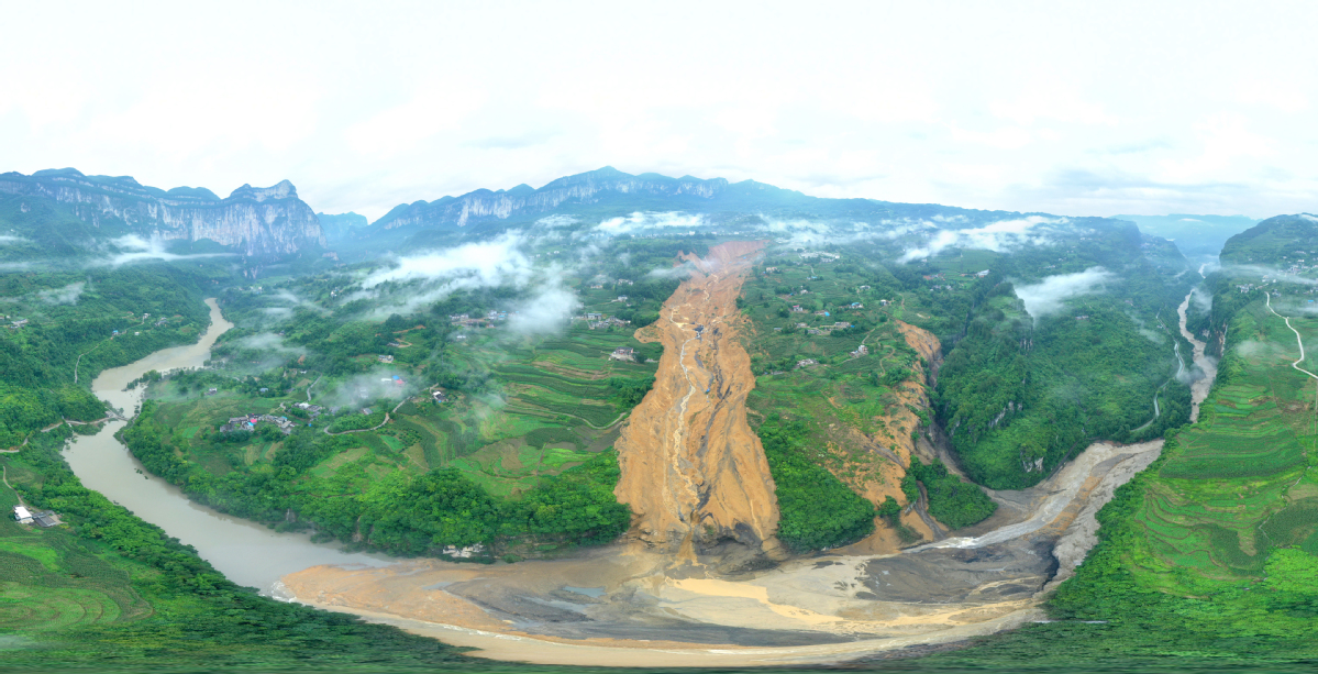
As the above image shows the failure, now known as the Shaziba landslide, temporarily blocked the river. In a paper recently published in the journal Landslides, Xue et al. (2021) have investigated the precursory movement of this landslide using satellite imagery.
The results are interesting. Their InSAR data demonstrates that the landslide seen above is part of a much larger complex, as shown in the figure from the paper below:-
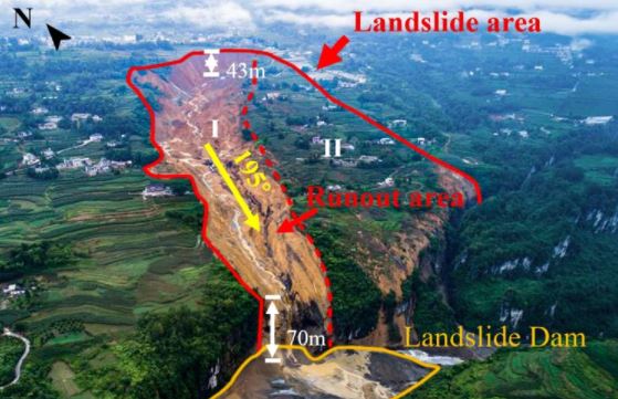
The full extent of the Shaziba landslide in China, from Xue et al. (2021).
.
The July 2020 landslide involved a volume of 250,000 cubic metres, with a length of 1,500 m, a width of up to 580 m and an average depth of 25 m.
The InSAR data shows that the landslide was creeping in the years leading up to the major failure. The creep was seasonal, with the higher rates of movement associated with the rainy season. This is unsurprising – presumably the landslide was responding to elevated pore water pressures. Detailed analysis of the data suggests that over time the landslide was becoming more responsive to rainfall, presumably an indication of the evolution of the landslide towards failure, and a possible indicator for a warning system.
Interestingly, Xue et al. (2021) have used InSAR to look at other slopes on the banks of the Qingjiang River, and have detected three further large landslide complexes that are showing seasonal patterns of displacement. These landslides, and the unfailed portion of the Shaziba landslide, now need monitoring. Fortunately InSAR represents a technique through which this can be achieved if there is sufficient funding for the processing.
.
Reference
Xue, C., Chen, K., Tang, H. et al. 2021. Heavy rainfall drives slow-moving landslide in Mazhe Village, Enshi to a catastrophic collapse on 21 July 2020. Landslides (2021). https://doi.org/10.1007/s10346-021-01782-7
27 October 2021
The cost of mitigating slope safety risk for Welsh coal waste tips
The cost of mitigating slope safety risk for Welsh coal waste tips
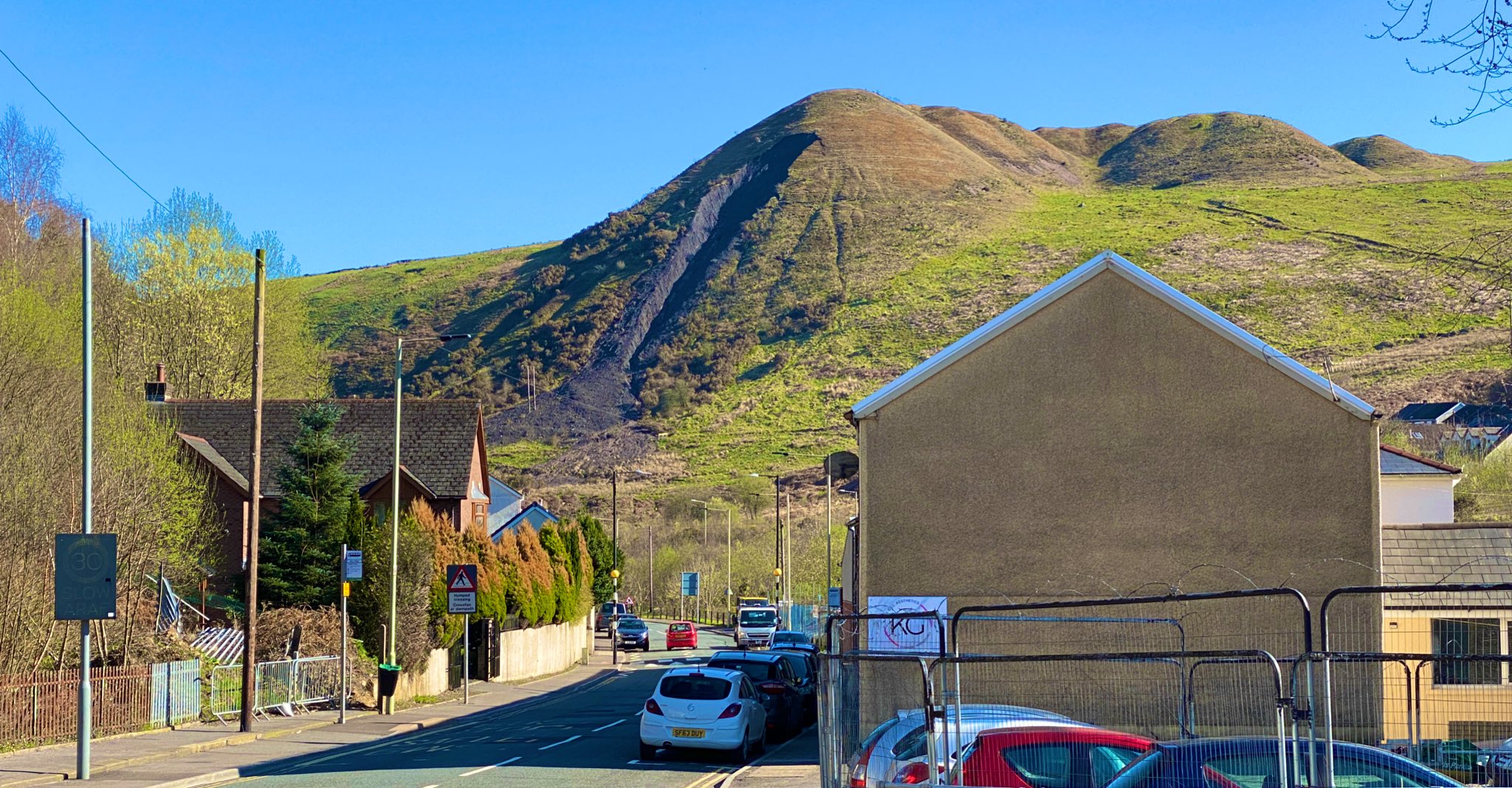
A small failure in a coal waste tip in South Wales. Image from Clear South Wales’ Coal Tips.
.
In February 2020 Storm Dennis triggered significant instability in a coal waste tip at Tylorstown in South Wales. Whilst mitigation of that problem is now underway, at very substantial cost, it has raised the issue of stability across the large number of coal waste tips across South Wales. Inevitably the underlying concern is a repeat of a major failure, as occurred at Aberfan 55 years ago this month.
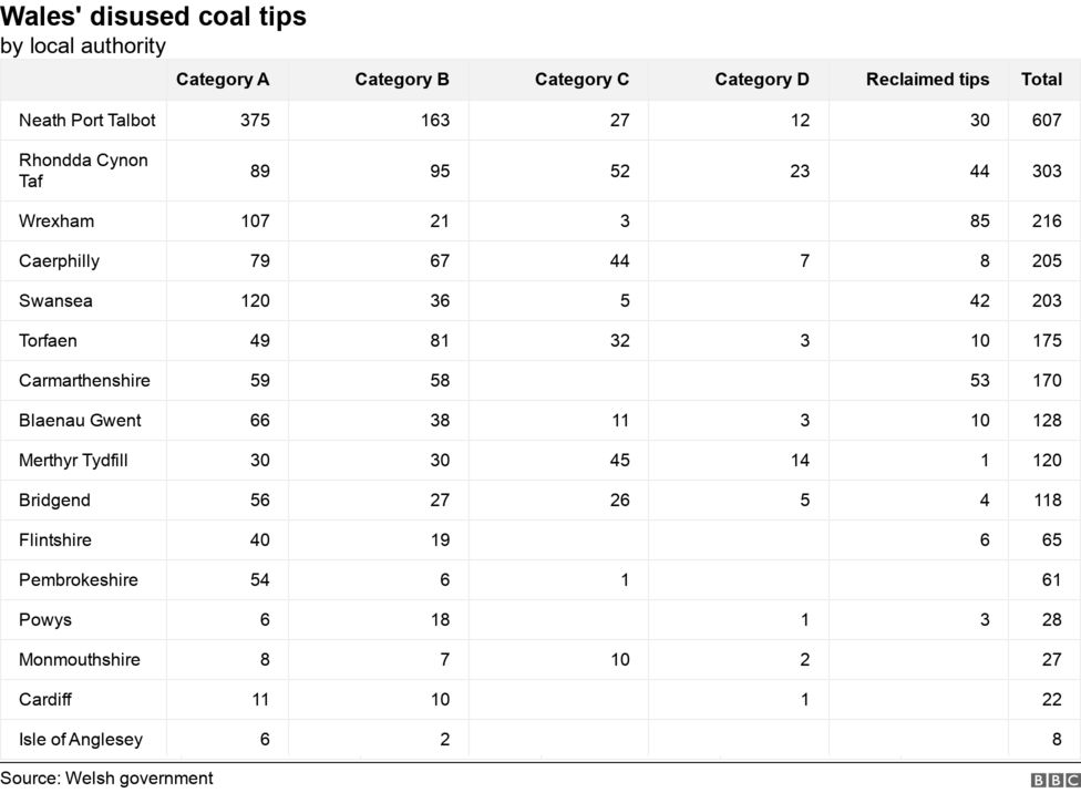
Yesterday the Welsh Government published the results of an analysis undertaken in the aftermath of Storm Dennis. This work has comprehensively documented the location of coal waste tips and has provided a first order analysis of their potential to cause risk to safety. The results, which do not make good reading, were discussed at a meeting of the Coal Tip Safety Summit yesterday.
In total 2,456 coal tips have been identified. They have been classified in terms of their safety from A to D, with A representing tips that are minor or have been restored, and D representing those posing the highest risk. The BBC has published a table presenting the results by area:-
Welsh Government data showing the classification of coal waste tips by region. Table from the BBC.
.
In total 327 tips have been classified as C and D and thus need remediation. Many of these coal waste tips are on private land, so the management of the hazard is far from simple. In no case is the risk considered to represent an immediate or imminent threat, but these coal waste tips are now being subjected to increased monitoring.
The Welsh Government has estimated that the cost of mitigating the high risk coal tips is likely to be at least £500 million over the next 15 years, but experience indicates that this will probably rise once the work begins. The issue will become more severe with time unless action is taken as rainfall intensities continue to increase and the waste piles continue to weather.
Meanwhile work will continue to develop techniques to monitor the coal waste tips through the coming winter. Meanwhile, the Twitter account Clear South Wales’ Coal Tips provides interesting commentary on the evolving situation.
26 October 2021
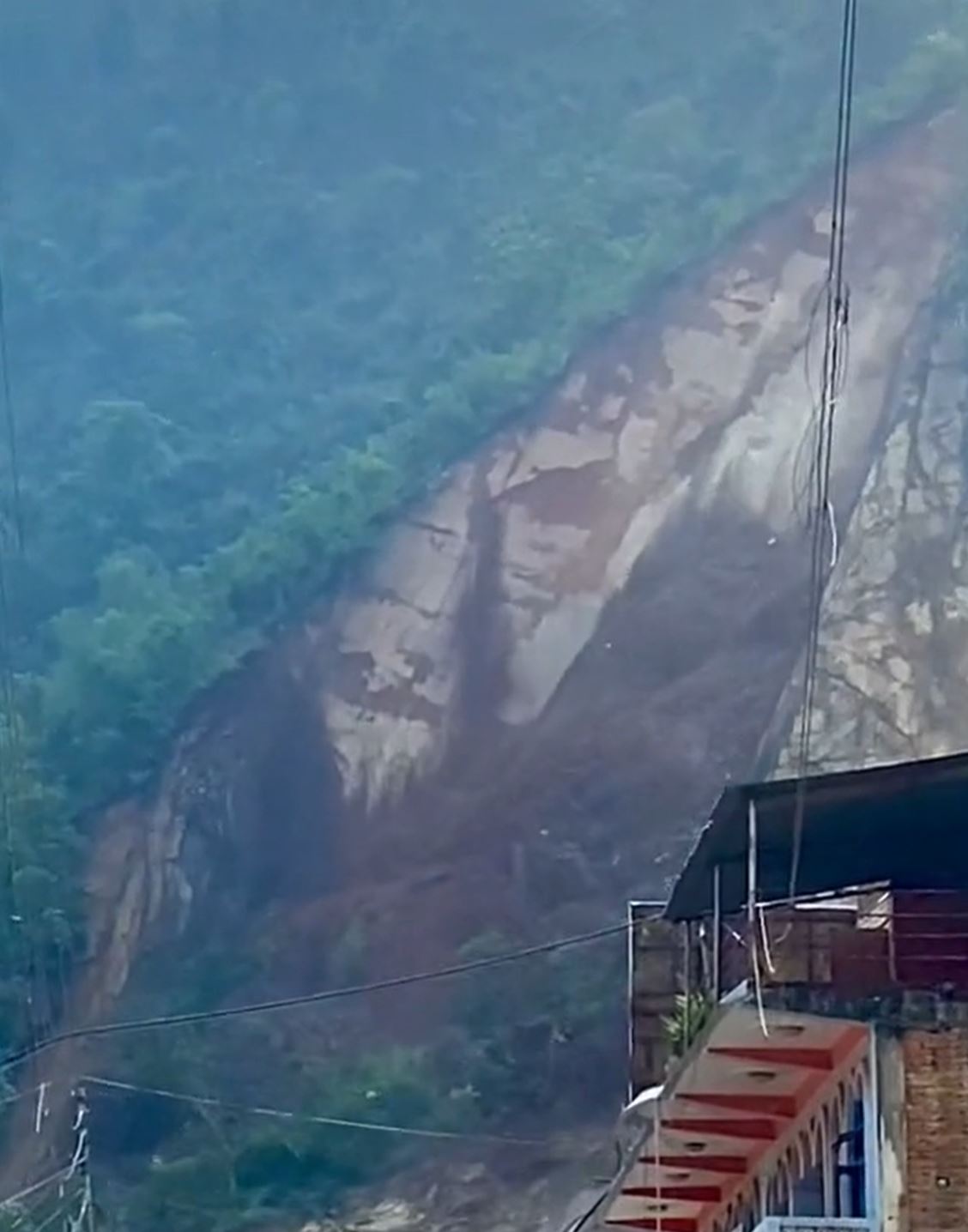
The 5 April 2021 Tiejiangwan landslide in Sichuan Province, China
The 5 April 2021 Tiejiangwan landslide in Sichuan Province, China
The journal Landslides has just published an interesting article (Liu et al. 2021) about the 5 April 2021 Tiejiangwan landslide in Sichuan Province, China. This failure, triggered by heavy rainfall, destroyed five houses, killing three people. The article provides a brief commentary on the events.
The image below shows the aftermath of the landslide (unfortunately the image appears to be mistitled as, according to the article, the landslide occurred in 2021 not 2020. This error occurs throughout the article):-
The aftermath of the 5 April 2021 Tiejiangwan landslide in Sichuan Province, China. Image from Liu et al. (2021).
.
As the image shows the landslide, which was triggered by heavy rainfall, initiated as a 30,800 cubic metre near-vertical rock slope collapse in thick-bedded sandstones with thin-bedded silty mudstones. The source area of the collapse was about 134 m long and 92 m wide. The debris initiated a debris slide that entrained colluvium on the slope. The debris ran out for a distance of about 1050 metres.
On 10 April 2021 further heavy rainfall triggered a debris flow in the landslide deposits. Further rainfall on 14 April 2021 triggered another debris flow. The debris dammed the main channel downstream, presumably requiring mitigation (although this is not described), to a height of over 3 metres.
This is an interesting example of a complex landslide involving a cascade of hazards starting with a fatal rock slope collapse. The evolution over time into debris flows that then blocked the main channel, inducing the risk of an outburst flood, illustrates very well the challenges of managing slope hazards in high mountain areas. Such landslides occur naturally (although changing patterns of rainfall mean that the frequency might be changing, and remobilised debris flows might be more likely. Such events are disasters because people are living in places that have a high level of vulnerability.
.
Reference
Liu, B., Hu, X., He, K. et al. 2021. Preliminary analyses of the Tiejiangwan landslide occurred on April 5, 2021 in Hongya County, Sichuan Province, China. Landslides (2021). https://doi.org/10.1007/s10346-021-01763-w
25 October 2021
A rockslide video from Pyuthan in Nepal
A rockslide video from Pyuthan in Nepal
The heavy rainfall last week in Nepal and India caused widespread damage including many landslides. Interestingly, as I type an atmospheric river event is affecting the West Coast of the USA, also with reports of of landslides. It will be interesting to see what the effects of that event will be, especially in areas affected by recent wildfires.
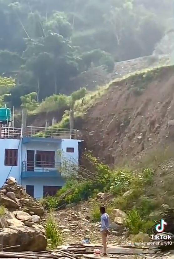
Pyuthan is a hill district located to the west of Nepal. A video emerged over the weekend of a very interesting landslide in Pyuthan, apparently triggered in this event (although this remains to be verified). This video was originally posted onto Tiktok by aashishsenchury10, but it has also been posted onto Twitter:-
https://twitter.com/sanjeevdevs/status/1451906525996347395
.
Unfortunately there is little information that I can find about the location of this dramatic failure. However, there are a few things to note. First it appears to be a wedge failure in bedrock. The post failure images show that the sliding was controlled by two very clear, pre-existing discontinuities in the mass. One of these is very clear in the image below, whilst the other is orientated towards the camera:-
A very clear discontinuity defining the block that slid in the Pyuthan rockslide. Still from a video posted to Tiktok by aashishsenchury10.
.
Second, there is landslide debris between the houses and the rockslide, indicating that this was not the first failure in this area. The age of this debris is not clear.
Third, immediately below the slope there is a road. I can only speculate on whether the construction of the road has been a factor in destabilising the slope. That is a factor that is common in many slope failures in rural Nepal.
And finally, perhaps most worryingly, some versions of this video (for example this one on Twitter) end with a view of the setting of the houses in the foreground:
The setting of the houses in the foreground of the Phyuthan landslide. Still from a video posted to Tiktok by aashishsenchury10.
.
This appears to show that the houses have been built adjacent to a very high, unsupported cut slope in colluvium. That does not appear to be a safe situation.
20 October 2021
A very late sting in the tail of the South Asian monsoon
A very late sting in the tail of the South Asian monsoon
As I have noted previously, the dominant continental scale meteorological phenomenon for landslides globally is the South Asian summer (SW) monsoon. In a normal year this develops in early June and withdraws through September. Heavy monsoon rainfall in mid October is not the norm.
But this year the summer monsoon has had a very nasty sting in the tail. Earlier this week I wrote about the serious landslides and floods in the Kerala area over the weekend. In the last couple of days it has been the high mountains of India and Nepal that have been affected.
In Nepal the rainfall has been very serious. The Department of Hydrology and Meteorology tweeted data and a map of rainfall totals across the country:-
#48hours_total_precipitation
Most parts of Sudurpachchim province received precipitation of more than 150 mm in 48 hours. A station in Dadeldhura district recorded 502.2 mm in 2 days. For real time rainfall information, pls visit https://t.co/xfWfmbmEq3#Flood #landslide #Nepal pic.twitter.com/AxJPiQp7Ya— Climate Analysis Section, DHM (@ClimateDhm) October 19, 2021
.
In Dadeldhura District in the west of Nepal rainfall totals on 18-19 October exceeded 500 mm. The consequences across the country are all too predictable – the Kathmandu Post reports that at least 18 people have been killed and a further 24 people are missing, with reports still coming in. This includes a probable debris flow that killed four people in Doti and three people killed in a landslide in Baitadi. The worst event might have occurred in Dikla village of Thalara Rural Municipality, Bajhang, where 24 people are reported missing in a landslide that buried seven houses.
Dr Basanta Raj Adhikari tweeted a video of landslides on the famous Dharan-Dhankuta highway, which is the best engineered mountain road in Nepal:
A number of landslides have blocked the Dharan-Dhankuta Road. pic.twitter.com/vvFvH2tyHK
— Dr. Basanta Raj Adhikari (@basanta58_raj) October 19, 2021
Meanwhile, in Uttarakhand in India the late monsoon rainfall has also had a devastating impact. Reports indicate that at least 47 people have been killed, with more reported missing. A serious incident occurred at the Ramgarh area of Bhawali Tehsil, Nainital, where a landslide killed nine people. India Today has this image of a landslide on the Askote-Jauljibi road in Pithoragarh:–
A monsoon-induced landslide on the Askote-Jauljibi road in Pithoragarh in India. Image from PTI / India Today.
19 October 2021
The Mira Mar landslide in Albany, Australia
The Mira Mar landslide in Albany, Australia
In the Mira Mar suburb of the city of Albany in the southern part of Australia a landslide is slowly destroying a number of houses. I have covered such events before around the world – when this occurs it is devastating for the home owners.
The landslide, which has been moving since at least August, has been linked with heavy winter rainfall. The location is Sleeman Avenue, which can be seen in the image below:-

Google Earth image showing the location of the landslide at Mira Mar in Albany, Australia.
.
Three houses have been evacuated and a further three are threatened. A part of Sleeman Avenue has collapsed. This is a site that would benefit from drone footage to understand what is occurring, but GWN7 News has posted a video on Facebook with a series of images that are useful:-
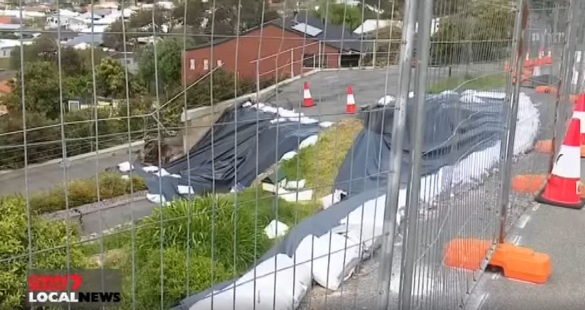
A part of the landslide at Mira Mar in Albany Australia. Still from a video posted to Facebook by GWN7 News.
.
This image, which I think was taken from Sleeman Avenue, shows a very large rear scarp with substantial vertical and horizontal movement. Meanwhile the image below, presumably taken from lower down the slope, shows serious deformation within the landslide mass that is causing structural damage to the houses:-
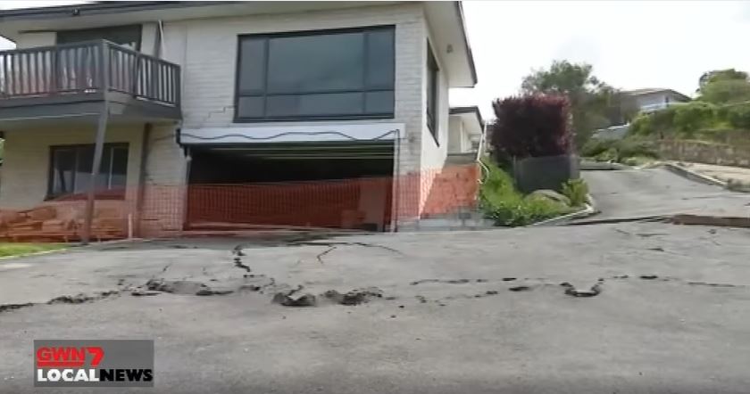
The lower part of the landslide at Mira Mar in Albany Australia. Still from a video posted to Facebook by GWN7 News.
.
News reports suggest that this area had been identified as being potentially unstable:-
A 2013 City of Albany report noted ground movement on Sleeman Avenue, where cracks in the road surface had appeared.
The Mira Mar residents link the landslide to a water main leak on 30 July, possibly caused by movement of the ground. This scenario is not unusual – movement of the soil causes the failure of a water pipe that then feeds more water into the ground, exacerbating the problem. The role of the water pipe rupture is disputed by the operators of the water main:
Water Corporation Great Southern regional manager Adrian Stewart said initial findings from geotechnical surveys commissioned by the authority and the City of Albany suggest above-average rainfall in winter and an “extreme Albany storm event in late July” likely caused of the slip.
Mr Stewart said the burst water main released about 70,000 to 140,000 litres of water, compared to the estimated 2.7 million litres of rain in winter.
Whilst it is impossible to draw any conclusions without detailed investigations, I do not believe that the role of the water main should be discounted so simply. First, if the water main fed 70,000 litres or more of water into the slope in a short period (a day or two) then at that particular time it might have been very material to the stability of the slope. And second, when slopes are very close to a factor of safety of one comparably small amounts of water can be enough to trigger failure.
That is not to say of course that the water main was responsible, but I do not think it can be ruled out without a proper survey.
18 October 2021
Multiple fatal landslides in Kerala, India
Multiple fatal landslides in Kerala, India
Heavy rainfall in Kerala, SW India, since Friday has triggered landslides and floods that have killed at least 26 people. It appears that most of the deaths have occurred in landslides and debris flows.
A large failure occurred at Poovanchi, destroying five houses and killing at least seven people. The Indian Express has a good image of the landslide:
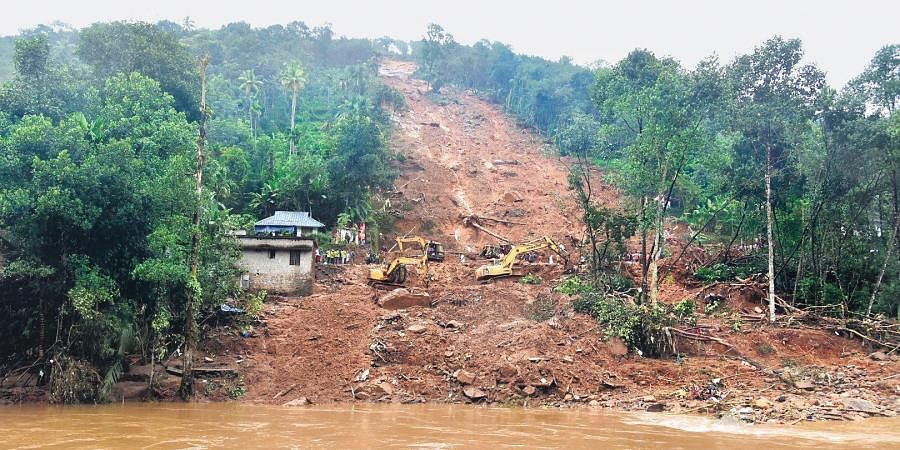
The 16 October 2021 landslide at Poovanchi in Kerala India. Image by EPS, Albin Mathew, via the Indian Express.
.
The landslide is apparently about 500 m long. The Indian Express article links the failure to unregulated local quarrying:
But was that purely an instance of natural calamity? Not necessarily. Local people suspect the landslide in Poovanchi has more to do with man’s greed than nature’s fury. Poovanchi is located in an area made fragile by unregulated quarrying. A hill in the remote village has more than two quarries. The granite quarry on the opposite side of the hill, where the landslide happened, has scooped out a portion equal to what was lost to the landslide.
Unfortunately I am unable to find an image of the source area to verify whether quarrying might have played a role.
A further significant landslide occurred at Kavali in Koottikkal in Kerala, in which six people were killed:-
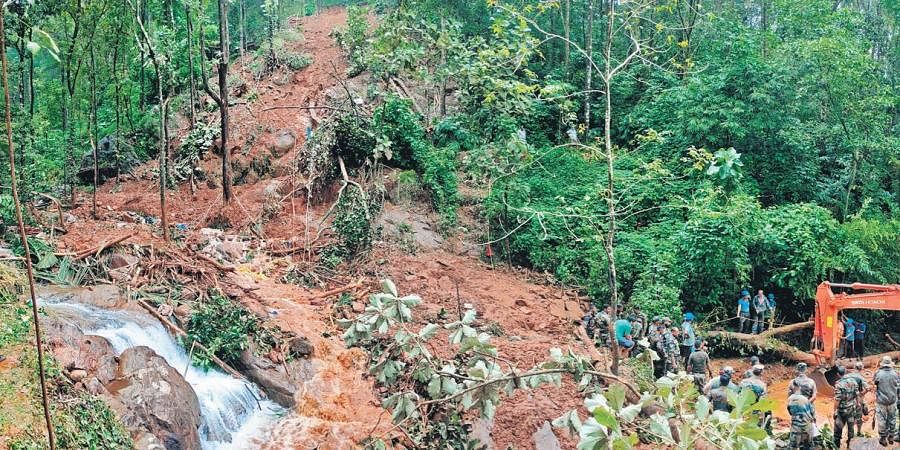
The landslide at Kavali in Koottikkal in Kerala, India, which killed six people. Image by EPS, Vishnu Prathap, via the Indian Express.
.
Three of the people killed were children, aged 14, 12 and 10.
Kerala, located on the west side of India, frequently suffers from landslides during the monsoon. However, this event is comparatively late in the annual cycle. It appears that the heavy rainfall is now subsiding, which should allow the recovery operations to be completed. Heavy rainfall has affected other areas of South Asia in recent years. The Melamchi area of Nepal has once again suffered from serious damage, and there are warnings of rainfall across other areas of Nepal.
15 October 2021
Indications of landslides on Google Street View
Indications of landslides on Google Street View
Yesterday I was reading an article (Rayes-Carmona et al. 2021) in the journal Landslides that described the movement of a large landslide on the banks of the Rules Reservoir in Spain. This slide, the El Arrecife Landslide, is a 14.7 million cubic metre creeping mass movement (location = 36.872, -3.491) that was detected comparatively recently. Analysis using historic InSAR data indicates that it is moving on average at about 2 cm per year, but that sections of the slope are moving at 26 cm per year. There are no immediate causes for concern, but clearly the landslide needs careful attention.
This Google Earth image shows the slope in question:-
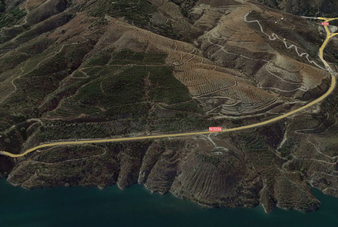
Google Earth image of the El Arrecife Landslide in Spain.
.
The slope shows few signs of classic landslide morphology such as obvious lateral scarps and a rear tension crack or scarp. There is a large spoil heap toward the toe of the slope on the centre right of the image – it is this feature that is showing the greatest movement, probably because the spoil is compacting – but the rest of the landslide is creeping.
An aspect of the paper by Rayes-Carmona et al. (2021) caught my attention:
The activity of the El Arrecife Landslide has been also evidenced by the N-323 National Road that runs across the landslide. This road has been consistently in need of repair work due to the existence of bumps, cracks, and partial collapses of the road pavement … In 2013, the Spanish Ministry of Public Works and Transport invested a total of 3.8 million Euros to repair 8 km of the N-323 National Road, which entailed the resurfacing of the pavement and the structural restoration of the northern abutment of the El Arrecife Viaduct …, located in the southern limit of the El Arrecife Landslide.
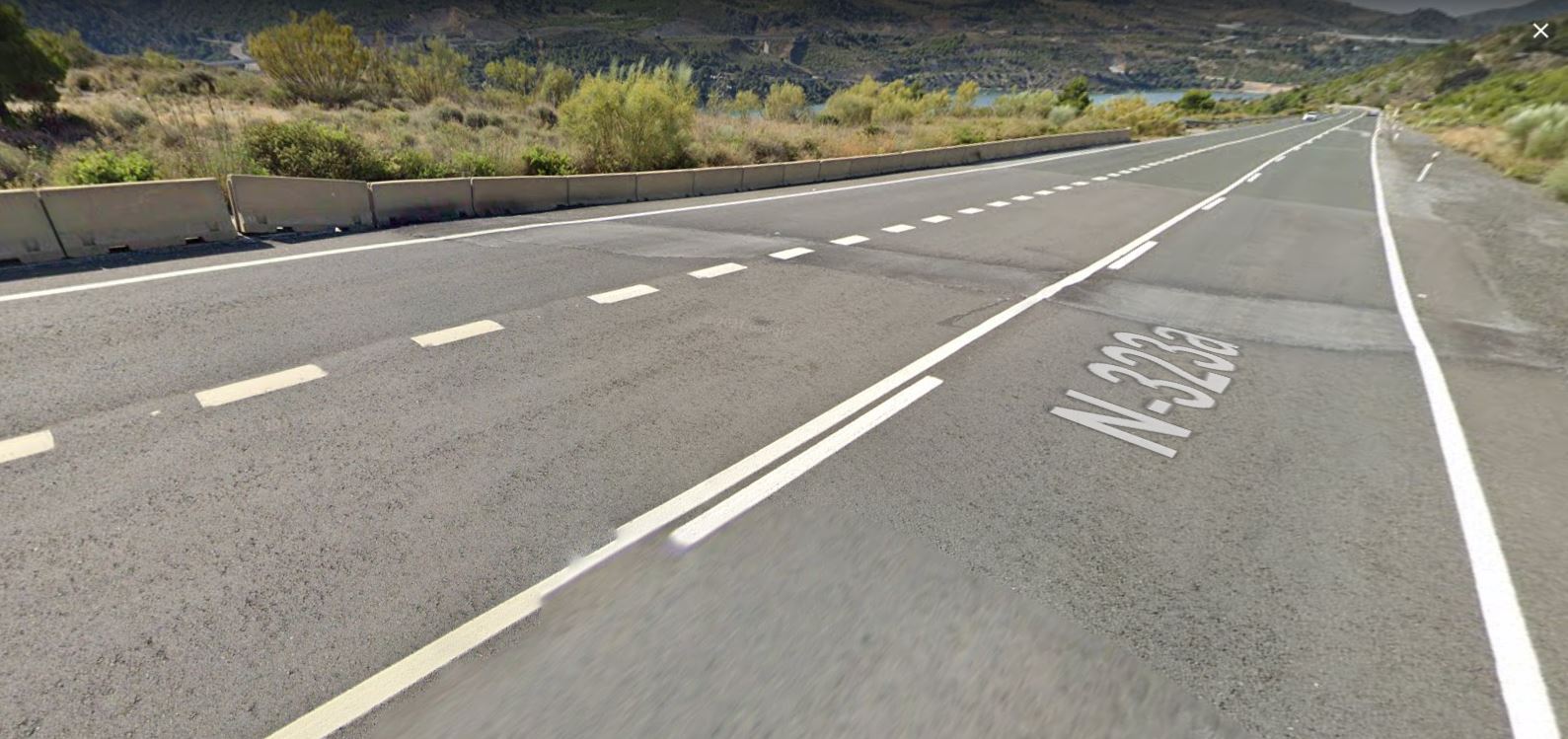
There is good coverage of this area in Google Street View. The image from June 2021 at the margin of the landslide looks like this:
June 2021 Google Street View image of the lateral margin of the El Arrecife Landslide in Spain.
.
The image beautifully captures the lateral margin of the landslide, with a large patch in the road where repairs have been needed. Note also the subsidence of the blocks on the downslope margin of the highway, coinciding exactly with the road repairs. These are classic indications of landslide movement.
The images also allow the history of movement to be determined. This image is from May 2011:
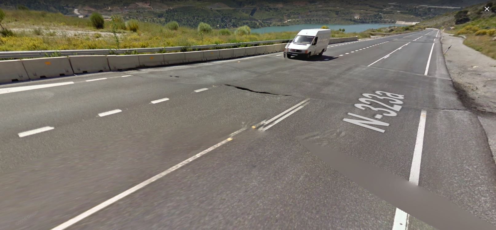
May 2011 Google Street View image of the lateral margin of the El Arrecife Landslide in Spain.
.
At this point a much larger repair to the road had been required. Note the lateral offset of the white line on the edge of the road, indicating relative motion. There is less evidence of vertical motion. Further down the road there is another large set of repairs, possible indicating an arcuate scarp defining a smaller area of more rapid motion.
In the image from May 2014 the road had been upgraded and repaired, such that the tarmac surface appeared undamaged. But by October 2018 cracks were reappearing and the curb side blocks were showing clear signs of movement. There is some evidence that this short section had been resurfaced once more:
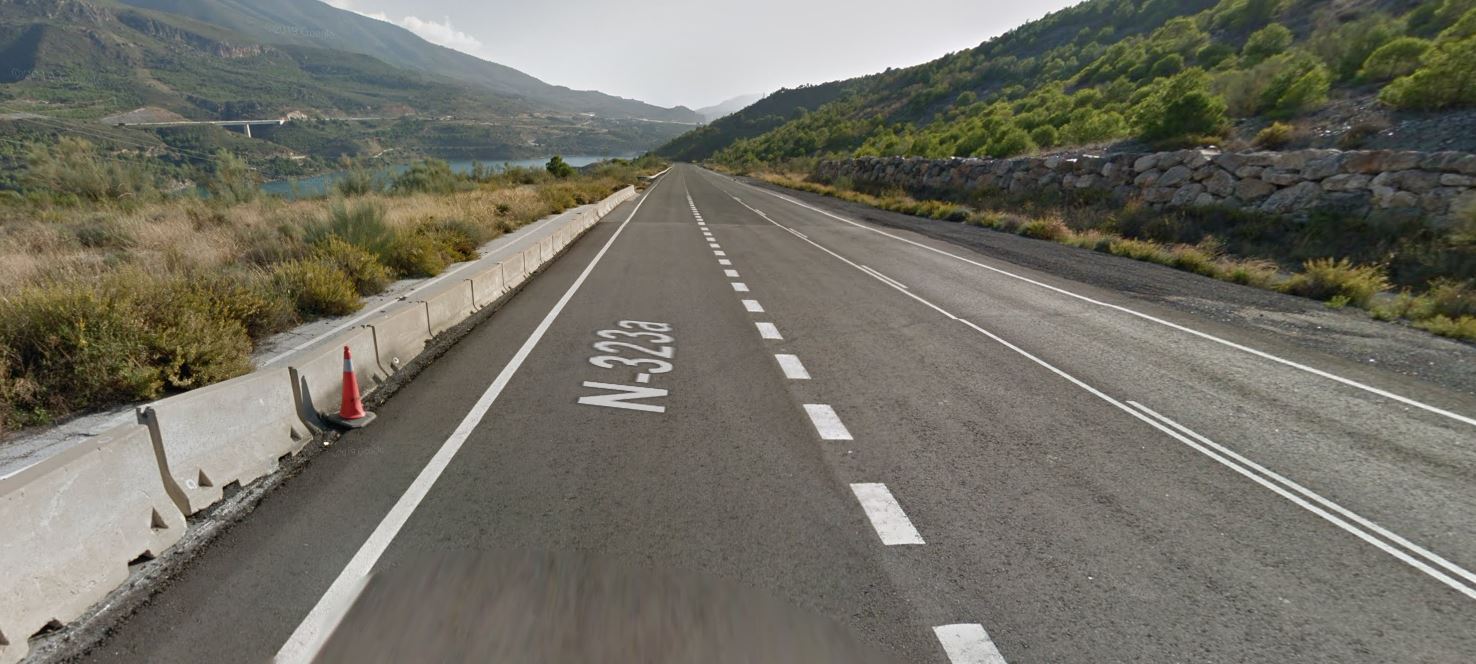
May 2014 Google Street View image of the lateral margin of the El Arrecife Landslide in Spain.
.
Understanding landslides is often a fascinating piece of detective work, piecing together multiple strands of evidence to create a coherent understanding in the three dimensions and in time. That is one of the reasons why I love studying them so much. Google Street View can be a remarkably powerful tool to aid this process in the right circumstances.
.
Reference
Reyes-Carmona, C., Galve, J.P., Moreno-Sánchez, M. et al. 2021. Rapid characterisation of the extremely large landslide threatening the Rules Reservoir (Southern Spain). Landslides (2021). https://doi.org/10.1007/s10346-021-01728-z.
14 October 2021
Large rock slope failures on the Southern Patagonian Icefield
Large rock slope failures on the Southern Patagonian Icefield
Loyal reader Hernán De Angelis has very kindly highlighted two very interesting large rock slope failures on the Southern Patagonian Icefield (SPI) at Glacier Amalia. He has written about these on his blog, including some excellent satellite images. I decided to take a look at them using Planet Labs imagery.
The first that he has highlighted occurred between 24 and 27 March 2018 at -50.919, -73.601. This is a Planet Labs image of the aftermath of the landslide, with a large volume of debris sitting on the glacier:-
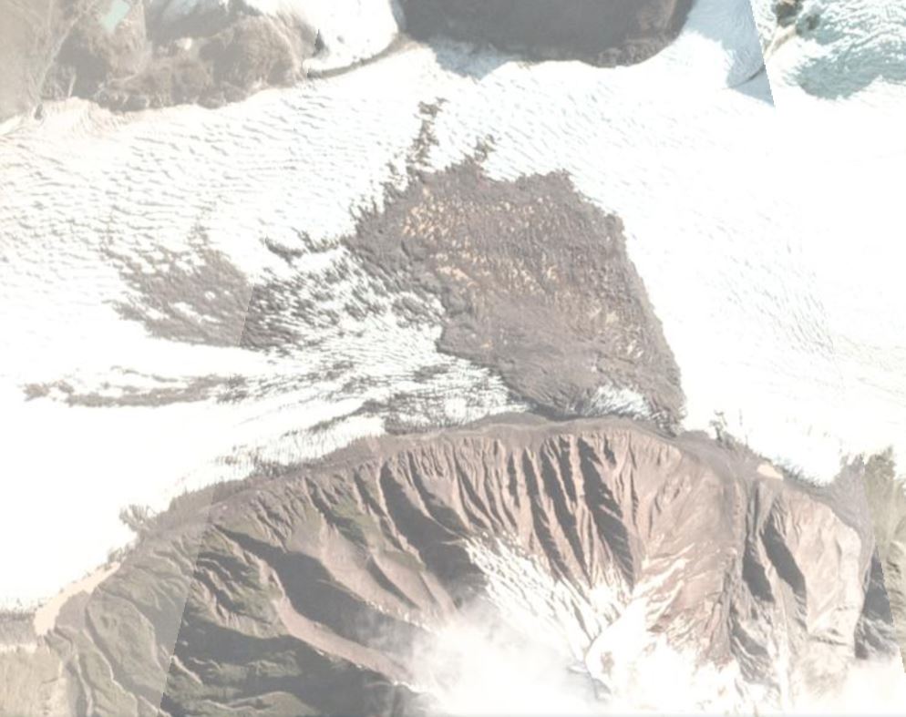
A satellite image of the landslide debris at Glacier Amalia on the Southern Patagonian Icefield, collected on 27 March 2018. Image copyright Planet Labs, used with permission.
.
Hernán has run the stats on this failure – it has a surface area of 1.6 square kilometres, with a runout length (on the glacier of 1.6 km – about a mile) and a width of 1050 metres. There are also some smaller failures, such as the one on the very right of the image. Interestingly, on flickr there is an image of the landslide deposit on the glacier.
Hernán has identified a second event a little to the east of this location on the Southern Patagonian Icefield, this time in 2019. This can be seen in a partially obstructed image on 28 April 2019 but the first image that captures it clearly is on 8 May 2019, when it was covered in a layer of snow:-
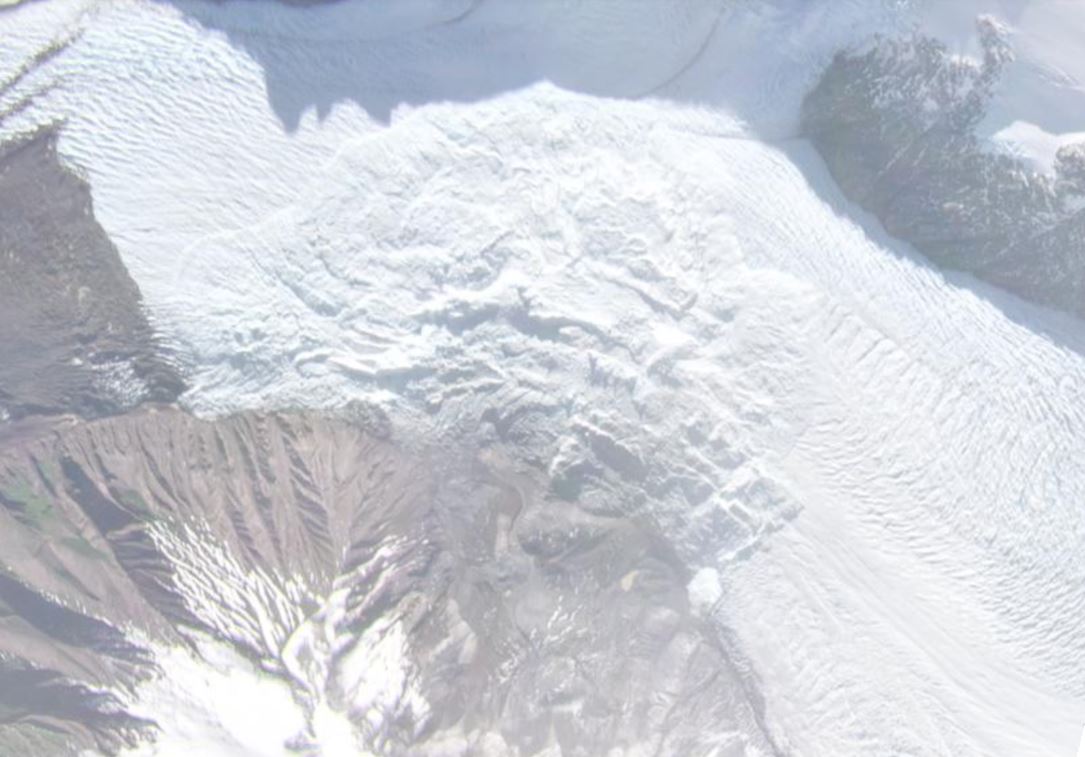
A satellite image of the 2019 landslide debris at Glacier Amalia on the Southern Patagonian Icefield, collected on 8 May 2019. Image copyright Planet Labs, used with permission.
.
This is a slope failure on a similar scale – about 1.6 square kilometres surface area. It is about 1,100 metres long (on the ice) and about 1,600 metres wide. Including the source area the length is about 2.5 km.
Hernán has pointed out that an abstract for the AGU Fall Meeting in 2019 (Van Wyk de Vries et al. 2019) mentions two landslides of this scale on the flanks of Reclus volcano. This is likely to be these two events. This what they wrote:
We identified a series of large debris avalanches from the volcanoes, suggesting that previously stable slopes have been disrupted. Two large (1-5 km2) avalanches occurred on the north flank of Reclus over the last two and a half years, and one 12 km2 avalanche occurred on the north flank of Lautaro earlier this year. Here we present a detailed description of the conditions preceding each collapse, and the properties of each collapse. The Reclus collapses are inferred to have been mostly unconsolidated rock, with moderate to low cohesion. The 2019 collapse was the larger of the two and settled onto Amalia glacier, causing local speedup and slowdown, possibly due to the loading of the ice.
.
References
Planet Team (2021). Planet Application Program Interface: In Space for Life on Earth. San Francisco, CA. https://www.planet.com/
Van Wyk de Vries, M. S. ; et al. 2019. Large Volcanic Landslides on the Southern Patagonian Icefield and Linkages to Glacial Retreat. American Geophysical Union, Fall Meeting 2019, abstract #V52C-07
13 October 2021
The Chgega landslide in Tunisia
The Chgega landslide in Tunisia
The Chgega landslide is an interesting and unusual slope failure located close to the village of Tahint in the Mateur region of northern Tunisia (36.901, 9.521 is the location – it is very clearly visible on Google Earth). Every landslide is of course unique, but this one is quite unusual. The landslide is described in an article in the journal Remote Sensing (Gaidi et al. 2021), in which the authors have used a variety of remote sensing methods to examine its movement. There is also a short summary on the Terradue website, which includes this image:-
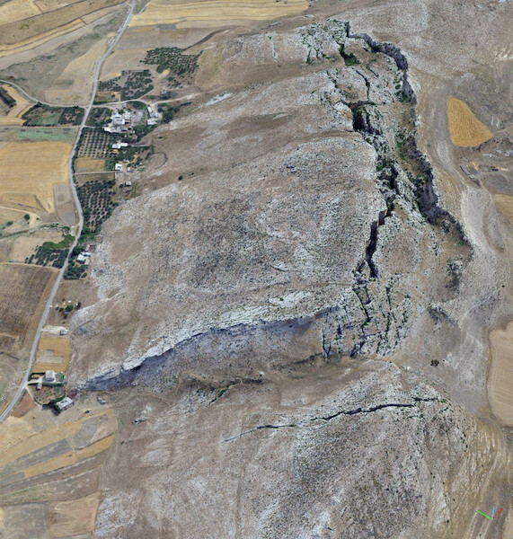
Aerial image of the Chgega landslide in Tunisia. Image posted on the Terradue website.
.
The landslide consists of a block of limestone that is 900 metres long and 400 metres wide sliding over a lower layer of clays and marls. The hill has a peak of 553 m asl, whilst the toe of the landslide is at about 395 m asl, giving a vertical extent for the Chgega landslide of about 160 m. The landslide is characterised by a rear scarp in the form of a huge graben, which is about 800 m long and up to 120 m wide.
This area of Tunisia is subject to active tectonic deformation, and as a result has a significant level of seismic hazard. Documented earthquakes in this area of Tunisia include major events in 410 AD and 856 AD. Thus, it is possible that the landslide was initiated by, and indeed principally moves during, earthquakes.
In their research, Gaidi et al. (2021) used a combination of INSAR and photogrammetry to measure the annual movement of the Chgega landslide. They concluded that over 4.7 years it moved a total of about 1 cm. Thus, this is a landslide that in asiesmic conditions is undergoing very slow creep type movements.
The Chgega landslide is a beautiful example of a spreading type of landslide. It’s accessibility means that it is worthy of further investigation. I shall certainly be adding it to my bucket list of places to visit when I retire.
.
Reference
Gaidi, S., Galve, J.P, Melki, F. et al. 2021. Analysis of the Geological Controls and Kinematics of the Chgega Landslide (Mateur, Tunisia) Exploiting Photogrammetry and InSAR Technologies. Remote Sensing, 13 (20), 4048; https://doi.org/10.3390/rs13204048.
 Dave Petley is the Vice-Chancellor of the University of Hull in the United Kingdom. His blog provides commentary and analysis of landslide events occurring worldwide, including the landslides themselves, latest research, and conferences and meetings.
Recent Comments