17 February 2020
Did South Wales suffer a coal waste landslide yesterday?
Posted by Dave Petley
Did South Wales suffer a coal waste landslide yesterday?
Yesterday morning the UK Met Office issued a rare red rainfall warning for South Wales, as a result of Storm Dennis. This was a prescient act as the rainfall duly triggered extensive flooding and a number of significant landslides. South Wales is a landslide prone environment – the Welsh Valleys have many natural landslides and, of course, many more that are a legacy of the mining coal mining that so dominated this area for many decades.
One particular landslide is of interest, and may be of real consequence. This occurred close to the village of Tylorstown, at approximately 51.656, -3.434. A part of the event was captured on a video that was posted to the front page of the BBC News website. There is a version of it on Youtube, though I suspect that this is not the original:-
.
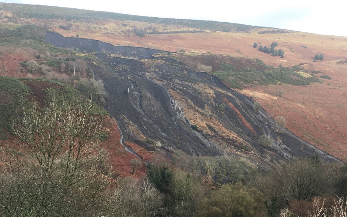
On Twitter, Owen Griffiths posted a very helpful panoramic image of the site of the landslide at Tylorstown:-

Panoramic view of the landslide at Tylorstown in South Wales on 16 February 2020. Photograph posted to Twitter by Owen Griffiths.
.
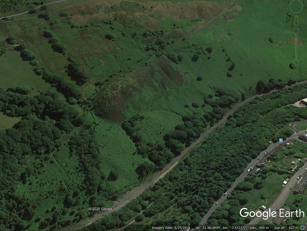
Based upon that image, I interpret the landslide as occurring on the slope shown in the Google Earth image below:-

A Google Earth image of the possible location of the Tylorstown landslide in South Wales on 16 February 2020.
.
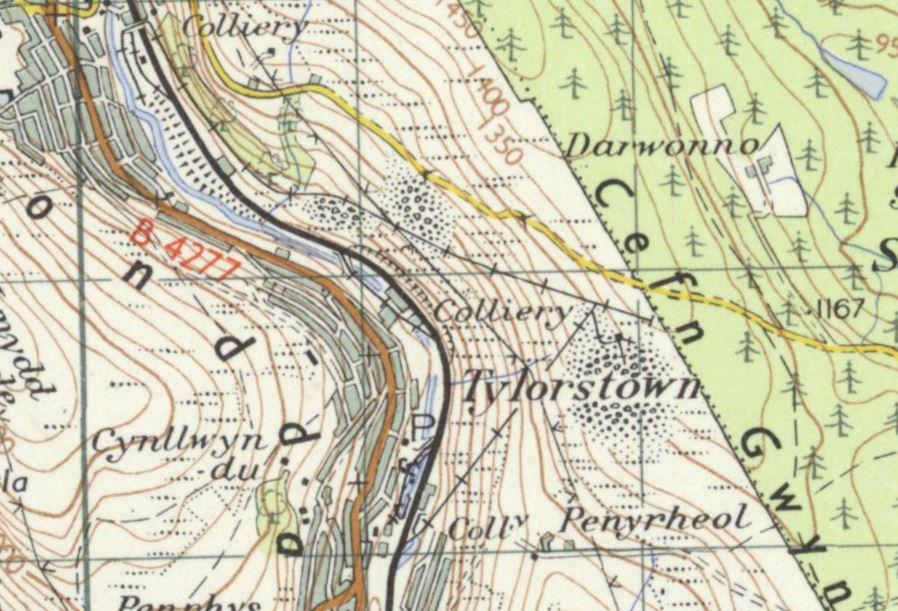
The origin of the landslide appears to be a spoil heap on the valley wall. The historic 1920-1940 Ordnance Survey map shows the route of the spoil conveyors from the Tylorstown Colliery (also shown on the map as Pendryrys Colliery) to this location, whilst the 1955-61 map shows spoil at this site:-

The 1955-61 OS One Inch 7th series map of the location of the Tylorstown landslide, showing spoil at the source of the failure.
.
The photograph of the site suggests that the failure captured on video was only a small part of a larger failure. We need better images, but on first inspection is appears that a large mass has slipped, leaving the large scar that can be partially seen at the rear of the failure, and that a small part of this slipped and disrupted mass has then turned into the more mobile flow captured on video.
Much more detail is needed on this failure than is available at the moment, but since the clean up after the Aberfan landslide coal spoil tip failures have been rare in Wales. If (and this is an unknown at this point) this is a coal waste landslide then we need to know why it has occurred. Is it possible that the new, extreme rainfalls that we are now seeing as a result of global heating are rather greater than had been anticipated when the reprofiling was undertaken?
That is a pressing question that can only be addressed by examining this failure properly.


 Dave Petley is the Vice-Chancellor of the University of Hull in the United Kingdom. His blog provides commentary and analysis of landslide events occurring worldwide, including the landslides themselves, latest research, and conferences and meetings.
Hi Dave and others,
There is a pretty good imagery on google earth, see the one from 1945 using the time travel tool… you’ll see that the landslide is coming from the upper spoil heap and going next to the lower one… I’m not sure reprofiling was undertaken there…
Pretty interesting to see other spoil heaps in the 1945 imagery as well…
Dont’t know if there is proper drainage system above or through the spoil heaps in general, but I agree climate change could bring stronger rainfalls, and so some slopes considered stable might move…
As usual thanks for the posts
These tips will be too early to feature integrated drainage, either of the material itself or the land beneath. As such, I suppose theor stability is questionable given weather conditions like we have had.
Might be looking in the wrong place, but looks like tip originally built on a couple of springs (from 1900s Digimap map). Excess pore pressure at the base?
Hi
I live over the mountain from this slip. If I get a chance I will pop out and see if I can get a few pics.
It is definitely a waste slip – there have been many small ones around the area (one just up the valley from me – 0.5 miles or so… Sorry for the Facebook link but here is a pic
https://tinyurl.com/uqy74hp – the one taken across the valley)
It is pretty unusual for valley sides to slip following the Aberfan disaster.
I would like to see the photo please. I cannot get the link to work .Dianne Huddle on fb ..
Interesting blog. You can also view the larger scale 1:10,000 Ordnance Survey sheet ST 09 NW, 1965 of this area on the National Library of Scotland website https://maps.nls.uk/view/189240354.
These legacy structures sure could be a significant headache with current weather patterns and climate trajectory. Shows that it’s not just hard formal structures like Whaley Bridge that are susceptible and that we should be on the lookout for a variety of legacy hazards.
… https://www.linkedin.com/feed/update/urn:li:activity:6648509071773229056?commentUrn=urn%3Ali%3Acomment%3A%28activity%3A6648509071773229056%2C6648870512019730432%29
…very true Bradley, should be a national monitoring campaign for these old sites that pose risk.
Quite possibly a pond in the middle of the coal spoil on a steep sided hill! I’ve asked the Local Authority to clarify…
https://www.facebook.com/groups/coaltips/permalink/477316640317040/