
19 November 2021
The 29 October 2021 Kameng River rock and ice avalanche in India
The 29 October 2021 Kameng River rock and ice avalanche in India
Back at the start of the month I highlighted an interesting event in northern India in which the Kameng River had seen a dramatic increase in turbidity and extensive fish mortality, based on an original post on the Discovering Aranchal blog. I suggested that this was likely to be a landslide or glacial event, but the source area was covered in cloud. Yesterday, the ever observant Dan Shugar noted that Planet captured a cloud free image on 17 November 2021, finally unveiling the sequence of events:
https://twitter.com/WaterSHEDLab/status/1461327866948321284
.
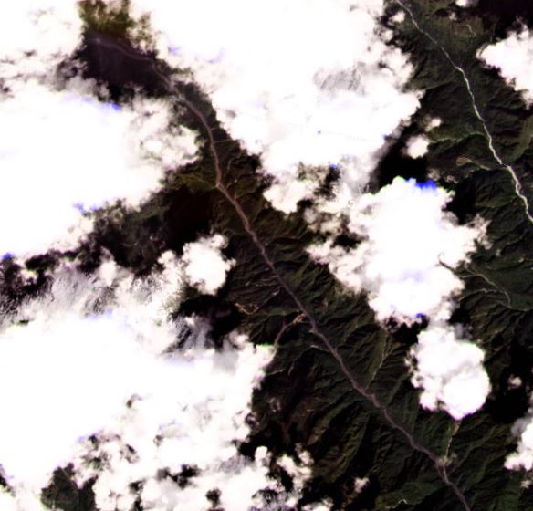
This is the Planet image that shows the area. Dan’s annotations in his tweet above indicate the source of the landslide that affected that Kameng Valley:-
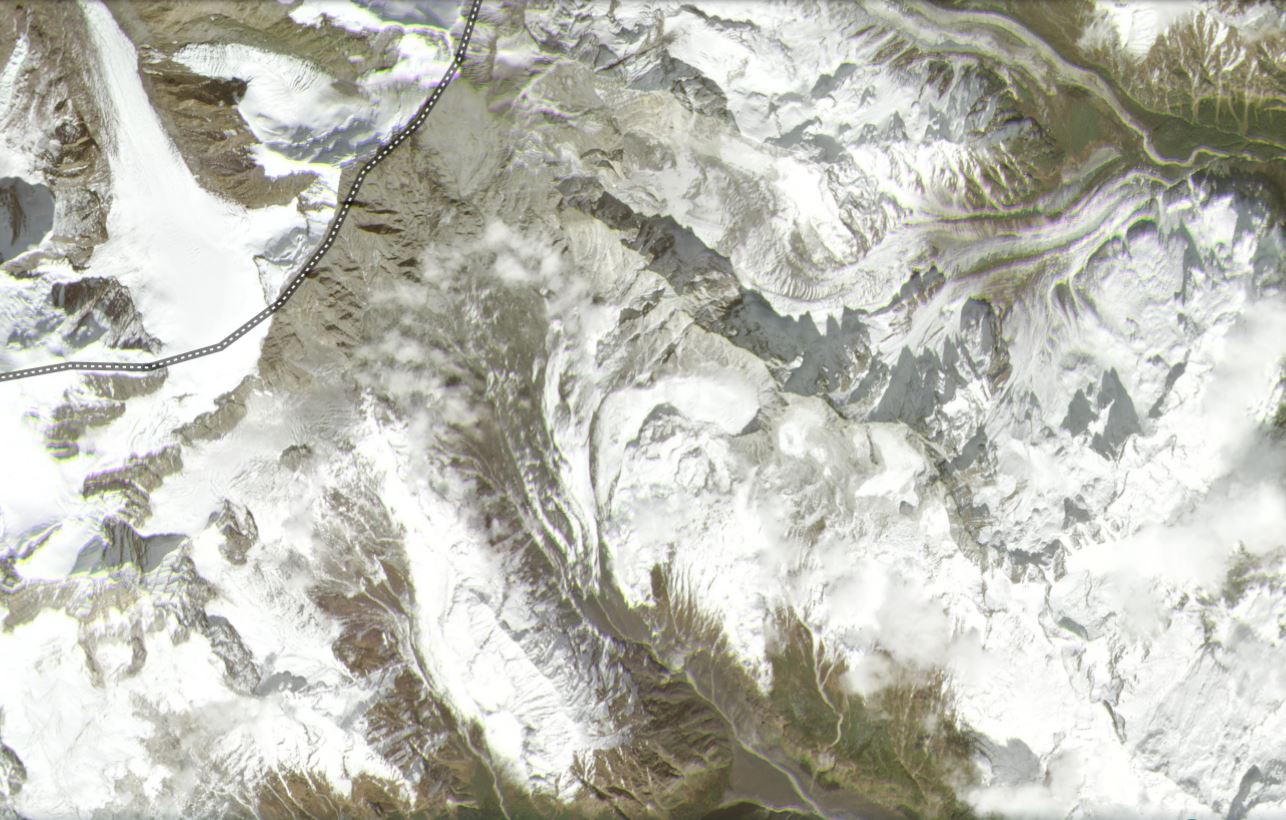
Satellite image, captured on 17 November 2021, showing the landslide affected area in the headwaters of the Kameng Valley. Image copyright Planet, used with permission.
.
It is useful to compare this with another Planet image of the same area, from November 2020:-
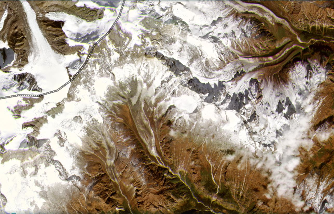
Satellite image, captured on 13 November 2020, showing the landslide affected area in the headwaters of the Kameng Valley. Image copyright Planet, used with permission.
.
And below is a slider that should allow the images to be compared:
.
The source of this event, as highlighted by Dan, appears to be a high altitude bowl. This feature is very clear in the Google Earth imagery:-
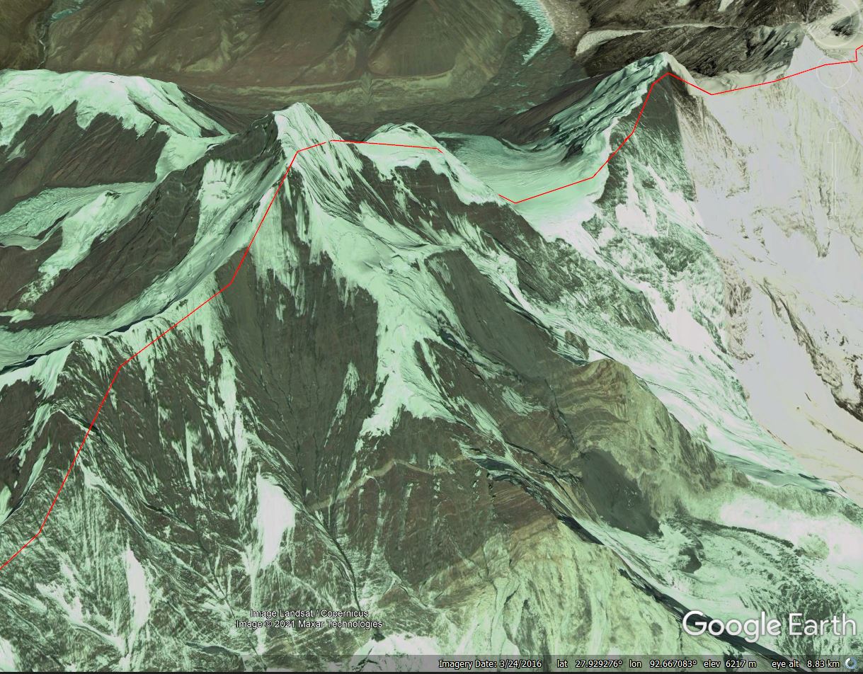
Google Earth image of the potential source of the landslide in the headwaters of the Kameng Valley.
.
A very provisional analysis is that some sort of slide appears to have developed in this area, which is about 600 m long and 700 m wide. This appears to have descended as near vertical slope onto the head of the glacier in the valley below. The vertical distance from the top of the peak to the top of the glacier is about 1,700 m. The images indicate massive fragmentation at this point, and the formation of a rock and ice avalanche that swept down the glacier, entraining material en route before transitioning into the flow that was observed down valley.
Provisionally this is broadly similar to the 7 February 2021 Chamoli event, although the mechanism of the initial failure is not clear at present.
.
Acknowledgement
Planet Team (2021). Planet Application Program Interface: In Space for Life on Earth. San Francisco, CA. https://www.planet.com/
18 November 2021
Landslides and the road network in Uttarakhand, India
Landslides and the road network in Uttarakhand, India
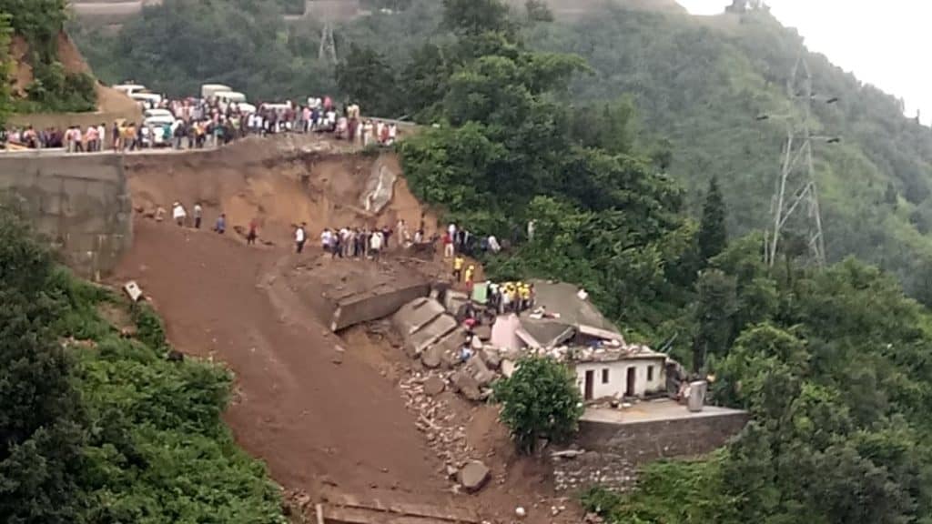
The Indian Express is carrying a story today about landslides and the so-called Char Dham road project. The Char Dham project involves widening and upgrading of 900 km of road between four population centres, Yamunotri, Gangotri, Kedarnath, and Badrinath, in Uttarakhand. I have blogged previously on this issue. The trigger for the Indian Express article is a set of comments made by the Union Road Transport and Highways Secretary, Giridhar Aramane, yesterday. These are the key quotes from the interview:
“So the allegation that highway construction is causing landslides is both spurious as well counter productive to the national causes”
And
“The area is generally prone to landslides, even where there is no road… geology of the area is so fragile that there is no need for any external provocations. Internal forces, plate movements itself causes enough landslides in that areas”
There are, of course, parts of this that are correct. The geology of the area is indeed fragile – this is an area of steep mountains in a fractured geology that is prone to seismicity and monsoon rainfall. Landslides are inevitable even without the action of humans.
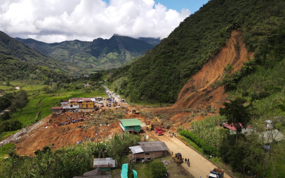
But to assert that highway construction is not causing landslides is demonstrably false. There are numerous images online of landslides on the Char Dham highways, such as these:-
A landslide on the Char Dham highway network. Image via Scroll.in
.
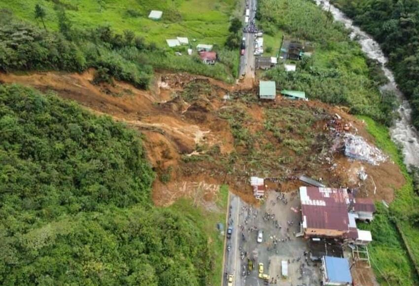
A landslide on the Char Dham highway network. Image via Scroll.in.
.
A landslide on the Char Dham highway network at Devprayag. Picture by Ayush Joshi via Citizenmatters.in.
.
I could not argue that India is incorrect to upgrade its roads – indeed there are undoubtedly strategic and development imperatives to do so. But in the fragile conditions of this area many landslides are inevitable during road construction unless high quality road engineering is adopted. To deny that the highway construction is causing landslides flies in the face of the evidence.
Landslides cause environmental damage, they drive economic loss, they kill people, they make the road network unreliable and, if there were to be a major earthquake, they make the provision of rescue and recovery extremely difficult, as was so evident in Pakistan in 2005 and in China in 2008. It is a folly to build roads in this way and it is a folly to deny the evidence of the impacts of these techniques on the landscape.
16 November 2021
Landslides and road damage from an atmospheric river event in British Columbia
Landslides and road damage from am atmospheric river event in British Columbia
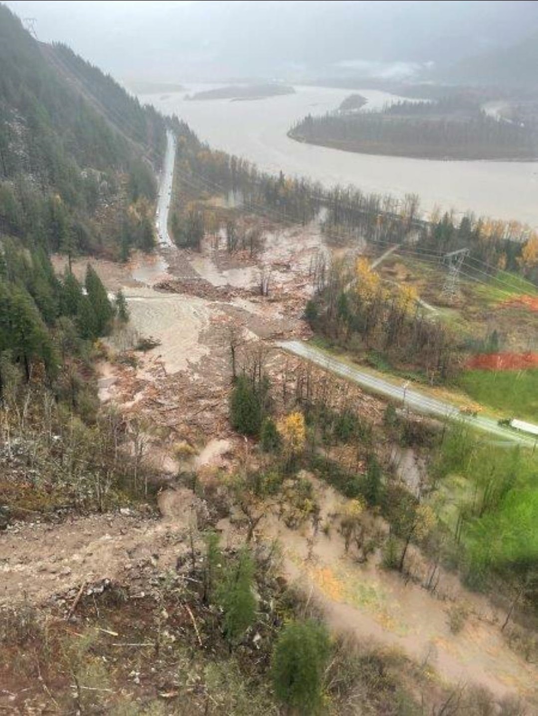
British Columbia, in western Canada, suffered an atmospheric river rainfall event on Sunday and Monday that caused extensive damage and many landslides. The full picture will not become clear until later this week, but levels of damage to the road network look to be high in places.
Live Journal has a good gallery of images of the aftermath, including this picture of a landslide on Highway 1 between Agassiz and Hope:-
A landslide on Highway 1 between Agassiz and Hope in British Columbia. Image from Livejournal.
.
Meanwhile another landslide occurred on Highway 5 to the north of Hope:-
A landslide on Highway 5 to the north of Hope in British Columbia. Image from Livejournal.
.
Perhaps the most spectacular problem has occurred on Highway 1 between Lytton and Nicomen. BC Transportation has tweeted a remarkable set of images of the impact at that site:-
A look from a flyover of #BCHwy1 at Tank Hill near Lytton and Nicomen.
For the latest #BCStorm travel info, check @DriveBC's website: https://t.co/0sq39Ad5WN#TransCanadaHighway pic.twitter.com/N4zVto5vNK
— BC Transportation (@TranBC) November 15, 2021
.
That is not going to be quick job to fix. I believe that this is within the area that was affected by the large wildfire in July 2021.
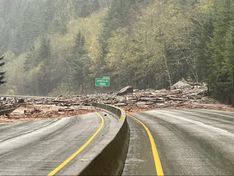
And BC Highways has also tweeted images of a mudslide on Highway 99 near to Lillooet:-
#BChwy99 near #Lillooet is closed due to a mudslide between Lil'wat Pl and Texas Creek Rd for 44.6 km. Assessment in progress.
Please check https://t.co/NCVlkn102s for updates. pic.twitter.com/UAJcfR9KaH— BC Transportation (@TranBC) November 15, 2021
.
Meanwhile, the Vancouver Sun reports that as many as 275 people were trapped between two landslides on Highway 7 near to Agassiz. It has a nice graphic illustrating the scale of the issue:-
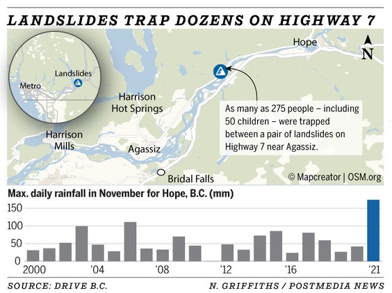
A graphic from the Vancouver Sun illustrating the scale of the issues caused by the atmospheric river in British Columbia.
.
The Vancouver Sun reports that 225 mm of rainfall was recorded at Hope in this storm.
Unfortunately it appears that there has been at least one life lost in these landslides, and the damage appears to be severe.
.
Acknowledgement
Many thanks to the various people who have provided information about this event, especially Charles Hunt and Susan DeSandoli.
15 November 2021
Landslides from the 14 November 2021 M=6.3 earthquake near to Fin in Iran
Landslides from the 14 November 2021 M=6.3 earthquake near to Fin in Iran
At 12:08 UTC on 14 November 2021 a M=6.3 earthquake struck Iran close to the village of Fin, 64 km to the north of Bandar Abbas in Iran. With a depth of 15 km, this was an event of sufficient magnitude to trigger landslides and damage to structures. Fortunately, it occurred in an area that is lightly populated, so the losses are likely to be low.
The area affected by the Fin earthquake is mountainous but very arid. Experience from similar settings (see our work on the 2010 Sierra Cucapah earthquake in Mexico for example – Barlow et al. 2014) suggests that such events will trigger significant numbers of landslides over the area affected. The arid conditions will mean that these release vast clouds of dust.
Interestingly, a series of videos have emerged on Twitter showing the landslides triggered by this event, posted by Mohammad Mohseni Aref from the University of Potsdam (@MohseniAref). The most circulated is this one, which is elegant for capturing both the landslides and the lorries rocking on their suspension as the earthquake waves passed through:-
#Laft_Earthquake pic.twitter.com/zCWZP6pC6C
— Mohammad Mohseni Aref (@MohseniAref) November 14, 2021
.
This is thought to have been taken on the road from Shahid Rajaie port, Bandar Abbas.
There is a similar video from a toll plaza closer to the mountains:
#Fin_Earthquake pic.twitter.com/Tonl8x6PwO
— Mohammad Mohseni Aref (@MohseniAref) November 14, 2021
.
The locatuon of this point appears to be consistent with the structures at 27.581, 54.249 on Google Earth. If so this is about 25 km from the USGS epicentre.
This one appears to have been taken from a vehicle travelling towards the mountains:-
#Landslide (Geno Mountain) after #Fin_Earthquake ,6.4Mw and 6.4Mw ,Depth 15 km pic.twitter.com/uZwIHevQ2w
— Mohammad Mohseni Aref (@MohseniAref) November 14, 2021
.
Geno Mountain is at 27.416, 56.144.
Perhaps the most spectacular was taken close to the mountain front, illustrating how even a small collapse can trigger vast amounts of dust:-
Very close video from #Landslide and #Rockfall (Geno Mountain) after #Fin_Earthquake ,6.4Mw and 6.3 Mw , Depth 15 km https://t.co/UJyR2Ee6mA pic.twitter.com/fjCWHuD1O5
— Mohammad Mohseni Aref (@MohseniAref) November 14, 2021
.
It will be interesting to see the satellite images from this event that should emerge today. Planet collected an excellent image from before the earthquake yesterday, and typically image this area every day. However, many of the landslides are likely to be small, so may be difficult to resolve.
.
Reference
Barlow, J., Barisin, I., Rosser, N., Petley, D., Densmore, A. and Wright, T. 2014. Seismically-induced mass movements and volumetric fluxes resulting from the 2010 Mw = 7.2 earthquake in the Sierra Cucapah, Mexico, Geomorphology, Available online 24 November 2014, http://dx.doi.org/10.1016/j.geomorph.2014.11.012.
12 November 2021
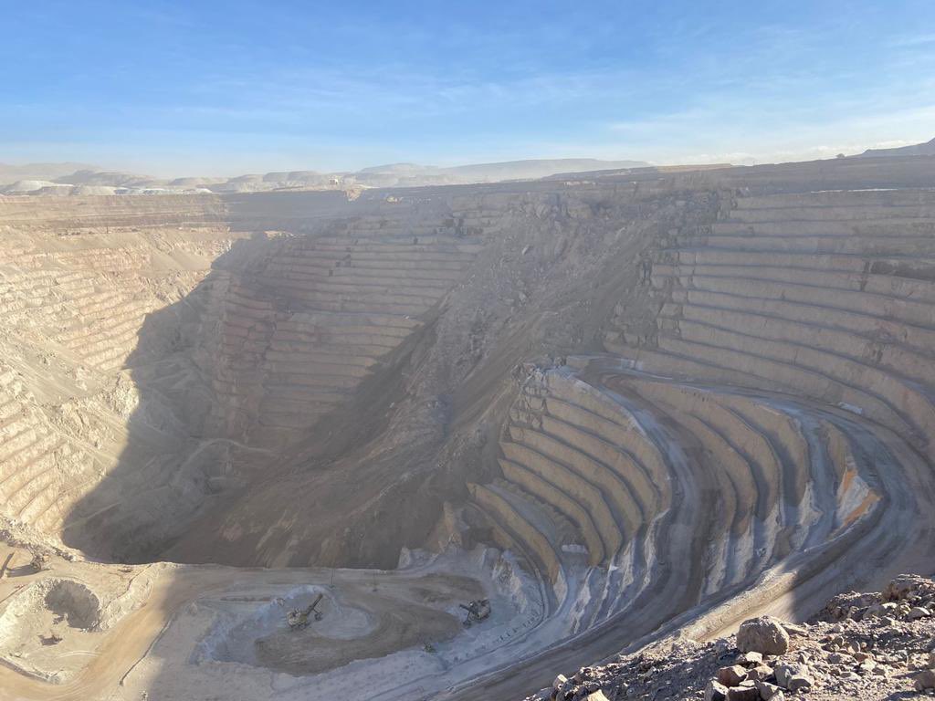
An update on the Ministro Hales mine landslide in Chile
An update on the Ministro Hales mine landslide in Chile
A picture has now emerged of the 9 November 2021 Ministro Hales landslide in Chile:-
The 9 November 2021 landslide at the Ministro Hales mine in Chile. Image tweeted by Marcela Hernando.
.
This confirms the satellite image that I published on Wednesday, showing that this is a large rockslide in a benched section of slope.
News reports indicate that the landslide was anticipated. Movement was detected in the wall in July, allowing a plan to be put in place to mitigate the threat. BNAmericas reports that Codelco have stated that:
“In July – through focused monitoring – the control and contingency plan was designed and defined based on the safety of people, which considered the total closure of all access to the identified area and preventive detention of the adjacent phase”
10 November 2021
A large landslide at the Ministro Hales mine in Chile
A large landslide at the Ministro Hales mine in Chile
Loyal reader Luis Donoso highlighted to me yesterday a tweet of a video that showed the aftermath of a very large landslide in a high wall mine:-
https://twitter.com/INSOLENTES/status/1458059234919141381
.
The tweet speculated that this was at the Ministro Hales mine in Chile, which is operated by Coldelco. A second tweet suggested that the failure might have been “expected and controlled”.
Planet Labs imagery of the Ministro Hales mine suggests that a large landslide did indeed occur at this site sometime between 8 and 9 November. An image captured at 13:55 UTC on 8 November shows no new landslide (although a smaller previous event is visible):
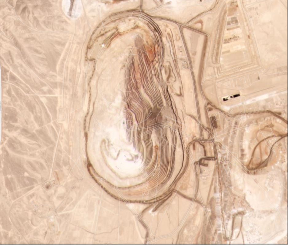
The Ministro Hales mine in Chile on 8 November 2021. Image Copyright Planet Labs, used with permission.
.
An image captured at 14:42 UTC on 9 November clearly shows a large landslide:-
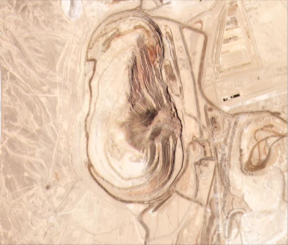
The Ministro Hales mine in Chile on 9 November 2021, showing the landslide. Image Copyright Planet Labs, used with permission.
.
I have tried to include this as a slider below so that the before and after images can be easily compared:-
.
.
Based upon the imagery the landslide is about 700 m long and 450 m wide. It has encompassed the existing slide but is far larger. The mobility of the landslide does not seem to be exceptional. There are some large blocks visible in the head scarp region.
Large rock slope failures in high wall pits are not unusual, and this is not the largest event that I have described. Big pits typically use radar and other monitoring methods to detect potential failures, so it is credible to believe that this landslide was anticipated. It will be interesting to see better imagery of the aftermath of the landslide, and to learn about the transition to failure.
.
Reference
Planet Team (2021). Planet Application Program Interface: In Space for Life on Earth. San Francisco, CA. https://www.planet.com/
8 November 2021
Mallama: a deadly landslide in Colombia on 2 November
Mallama: a deadly landslide in Colombia on 2 November
On 2 November 2021 heavy rainfall triggered a deadly landslide in the village of Mallama in Nariño Province of Colombia, killing 17 people and injuring a further nine.
The best image that I can find that provides a good view of this failure is on the Nariño Government website:-
The 2 November 2021 landslide at Mallama in Colombia, which killed 17 people. Image via the Gobernacion de Nariño.
.
Based on this image this is a failure in deeply weathered regolith on a very steep slope. It appears to have demolished a number of houses. This is probably best characterised as a debris avalanche, although with a comparatively moderate runout distance.
RCN Radio has this very dramatic image of the aftermath of the landslide from a different perspective:-
The aftermath of the 2 November 2021 landslide at Mallama in Colombia. Image by JHR Ingeniería via RCN Radio.
.
According to news reports, the site had not previously been identified as being at risk of landslides, and the reason for the failure at this time is not clear. There is however a risk of further failures that will necessitate the relocation of people whose houses are as yet undamaged.
2 November 2021
The Tonghua landslide in Sichuan Province, China
The Tonghua landslide in Sichuan Province, China
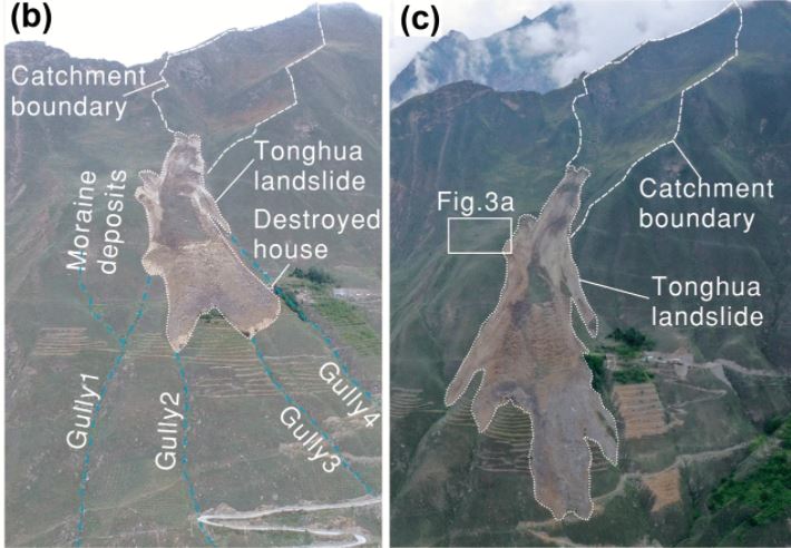
A paper just published in the journal Landslides (Cheng, Yang and Du 2021) describes the Tonghua landslide, which is located at 37.575, 103.414, in Sichuan Province, China. This landslide occurred on 8 August 2017. The authors used InSAR to extract pre-failure creep with rates in the order of 15-25 mm per year in the three years prior to the failure event.
This is a really interesting landslide – the image below shows the slope that failed before and after the event:
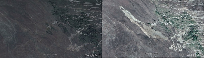
Google Earth images showing before and after the Tonghua landslide in China
.
The image below shows the landslide itself in more detail:
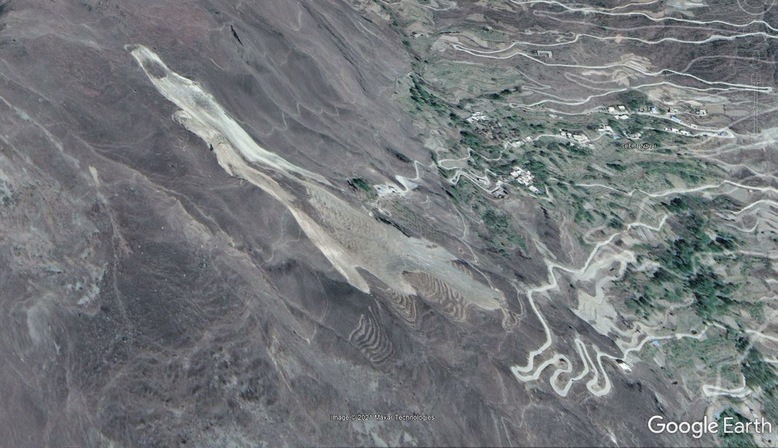
Google Earth image showing the 8 August 2017 Tonghua landslide in Sichuan Province, China.
.
As the image above shows, the Tonghua landslide is a 600 m long translational debris slide in moraine deposits, with a volume of about 220,000 cubic metres. The analysis of Cheng, Yang and Du (2021) suggests that three earthquake events are associated with the landslide. The epicentre of the M=8.0 2008 Wenchuan earthquake was 59 km south of the landslide, whilst the epicentre of the M=7.0 2013 Lushan earthquake was located 158 to the southwest. On the day of the landslide, the M=7.0 2017 Jiuzhaigou earthquake was located 195 km to the northeast, but as this occurred ten hours after the failure, it was not a factor. The first two earthquakes may have played a role in preparing the slope for failure.
Perhaps the most interesting aspect of the landslide is the trigger. Cheng, Yang and Du (2021) note that there was no seismic event that coincided with the failure, and that rainfall in the 30 days prior to the collapse was not exceptional. There was no heavy rainfall event in the days immediately preceding the collapse. However, 25 days before the failure event, drilling and blasting commenced for the CNH G4217 Tonghua No. 1 tunnel, close to the site. In the days leading up to the failure event, Cheng, Yang and Du (2021) record 13 blasting events, with the last occurring about one hour before the failure. They conclude that ground vibrations associated with the tunnel construction were responsible for the failure.
Since the main failure event the Tonghua landslide has continued to creep and to expand. Initially rates were high, but they have now declined to rates in the range of 0.1 – 1.0 mm per day. The image below, from Cheng, Yang and Du (2021), illustrates how the landslide has evolved since the initial failure event:
The evolution of the Tonghua landslide in China post-failure, from Cheng, Yang and Du (2021). The left image was taken on 9 September 2017, after the failure, whilst the right image was taken on 30 May 2019.
.
Reference
Cheng, Q., Yang, Y. & Du, Y. Failure mechanism and kinematics of the Tonghua landslide based on multidisciplinary pre- and post-failure data. Landslides (2021). https://doi.org/10.1007/s10346-021-01770-x
1 November 2021
A large landslide or glacial lake outburst in the headwaters of the Kameng River in Northern India?
A large landslide or glacial lake outburst in the headwaters of the Kameng River in Northern India?
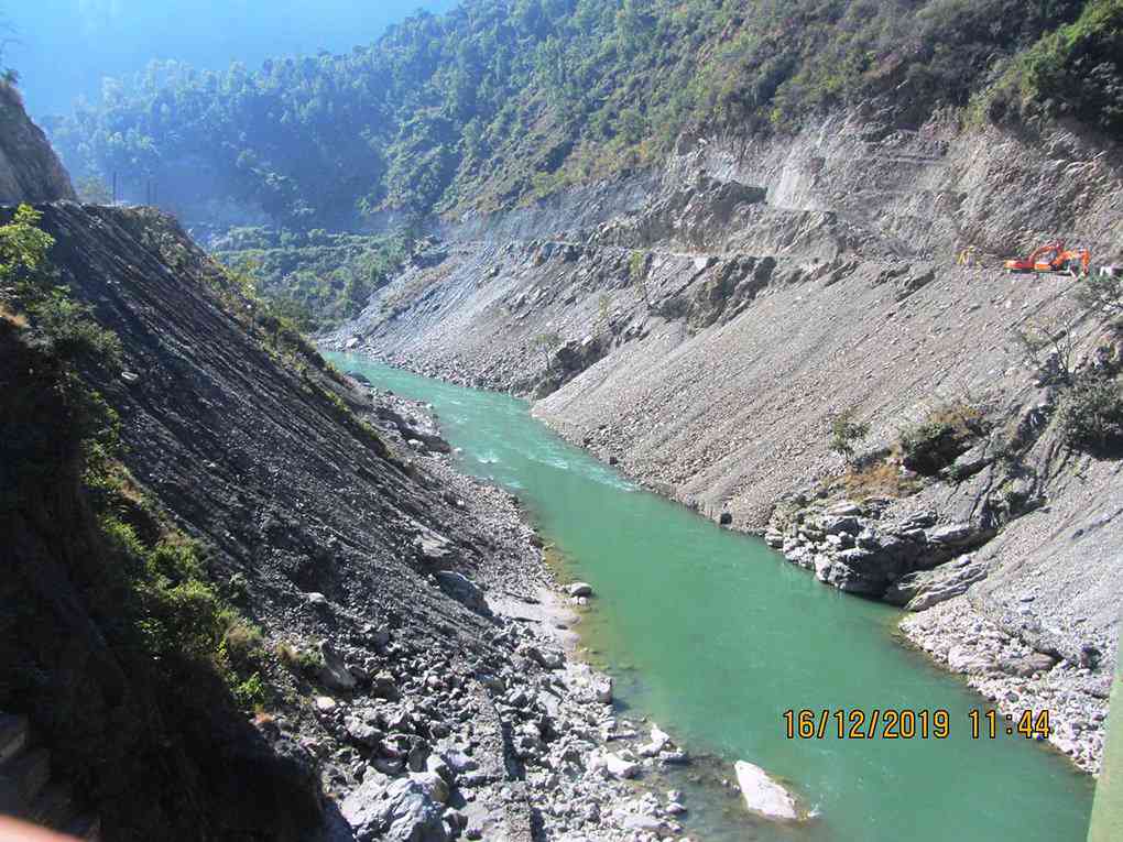
Loyal reader Robert Wasson has very kindly highlighted an interesting article in the Discovering Arunachal blog, posted on Saturday. This article observes that at about 10:30 am on 29 October 2021 the Kameng River in East Kameng district in Arunachal Pradesh in northern India became extremely muddy. News reports indicate that the measured dissolved solids increased by about five fold and there was a mass die off of the fish population in the river.
Chintan Sheth, the author of the Discovering Arunachal blog, has used satellite images to try to discover what caused this unexpected event. The upstream area, along the banks of the Warriyang Bung river, is almost permanently covered in cloud at this time of the year, but on 29 October 2021 Planet Labs captured an image of part of the Warriyang Bung river catchment, from which Chintan Seth has created an image of the impact of the event:-
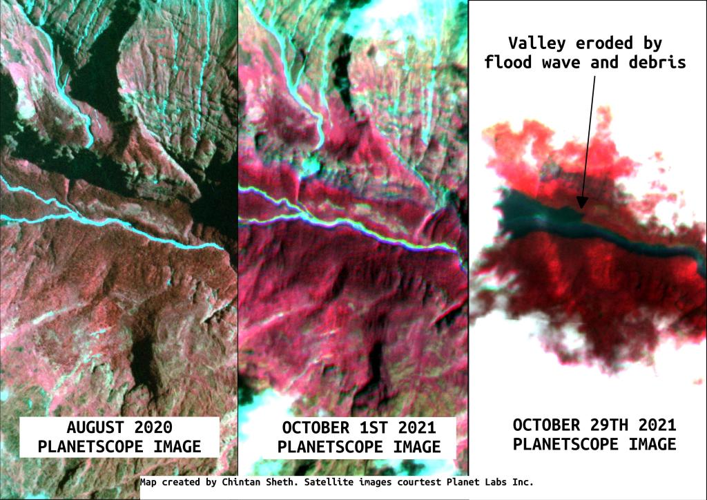
A composite set of Planet Labs images showing the change in the visible section of channel on the Warriyang Bung river in northern India. Image compiled by Chintan Sheth and published on the Discovering Arunachal blog.
.
The location of the site is 27.877, 92.702. The images appear to show that there has been heavy erosion and deposition along the river. Unfortunately the source of this event is under thick cloud.
Back on 1 October 2021 Planet Labs captured a beautiful image of the catchment:
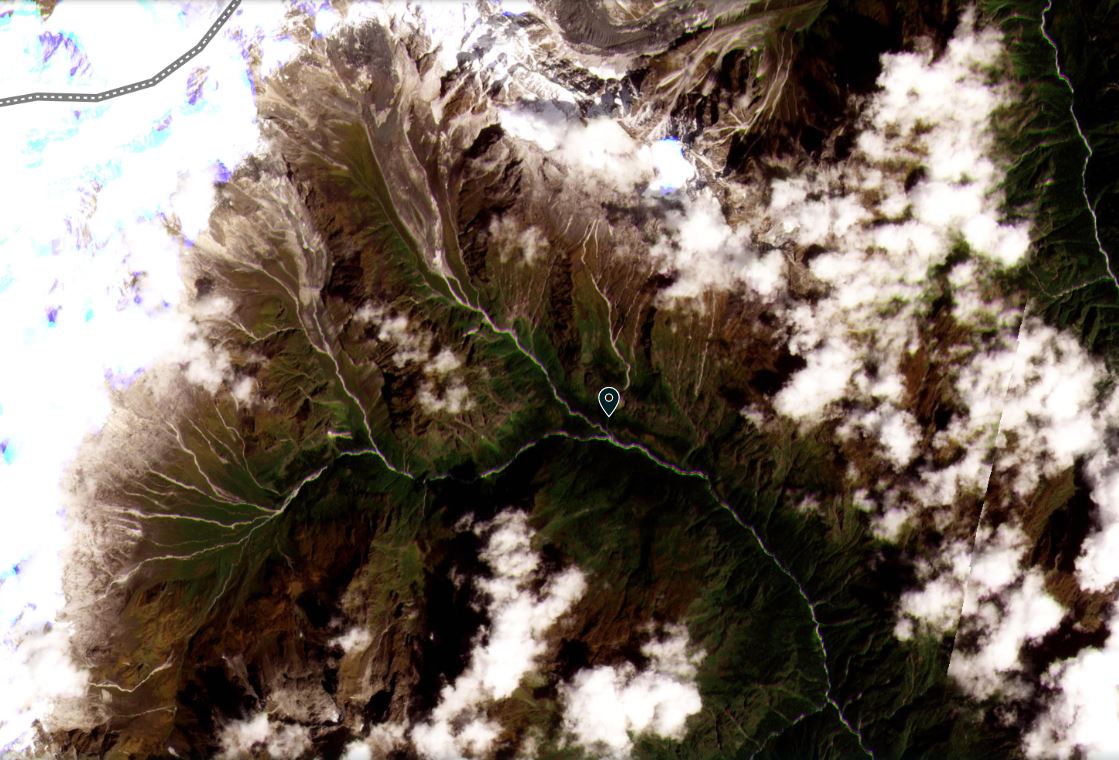
The catchment of the Kameng River that was the source of the event of 29 October 2021. Image copyright Planet Labs, used with permission, captured on 1 October 2021.
.
This is a complex catchment, with small glaciers and steep slopes. I cannot see any obvious glacial lakes, but these could be obscured by clouds. The most three obvious candidates for this event are the collapse of a glacial lake, a the collapse of a glacier or a rock slope collapse. The latter seems more likely, but we may not know until a cloud free image with low levels of snow becomes available. That might not be the case until the spring.
Imagery of the channel downstream shows erosion and deposition along the channel, suggesting that this was a significant event.
The upper catchment of the Kameng River showing changes to the channel following the event of 29 October 2021. Image copyright Planet Labs, used with permission, captured on 29 October 2021.
.
Reference
Planet Team (2021). Planet Application Program Interface: In Space for Life on Earth. San Francisco, CA. https://www.planet.com/
29 October 2021
The mobility of a rolling volcanic boulder
The mobility of a rolling volcanic boulder
On this blog I have frequently written about the mobility of boulders once they start rotating on their way down slope. A very beautiful example of this was posted to Twitter yesterday by Harri Geiger. The video was shot on the flanks of the still erupting Cumbre Vieja volcano on La Palma in Spain:
Spallation lava bomb coming down from #LaPalmaVolcano on 27 Oct 2021.#CumbreVieja pic.twitter.com/mvKFKn6rme
— Harri Geiger (@harrigeiger) October 28, 2021
.
The video captures a spallation lava bomb. As the video shows, this was a boulder that was roughly spherical, and it was moving on a surface essentially devoid of obstructions and that had, until late in the sequence, a steady slope. The resultant video is a remarkable record of the extreme mobility in these situations.
If the film Raiders of the Lost Ark is ever remade then this video of a high mobility, extremely hot boulder might be food for thought.
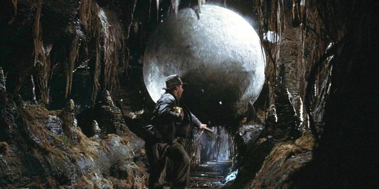
The boulder chasing Harrison Ford in the Film Raiders of the Lost Ark. Still from Screenrant.
.
Meanwhile, the eruption continues with a great deal of energy. There is no reported evidence of the much-hyped catastrophic flank collapse, and thus of the resultant mega-tsunami, as far as I can see. On 25 October Sotiris Valkaniotis tweeted his latest InSAR analysis of deformation on La Palma:
Cumulative displacement & interferograms from Copernicus #Sentinel1 imagery, for the past month of volcanic activity in #LaPalmaVolcano #Canarias. Descending interferogram has quite decent quality despite of 36d interval. Processed at @Ak_Satellite DAAC HyP3 using GAMMA. 1/2 pic.twitter.com/xbHkoLXRgj
— Sotiris Valkaniotis (@SotisValkan) October 25, 2021
.
As I’d expect, this shows inevitable inflation and deflation around the vents, but no indication of large scale instability in the flank. La Palma is being monitored closely by multiple groups using multiple sets of tools, so any changes would be rapidly detected.
 Dave Petley is the Vice-Chancellor of the University of Hull in the United Kingdom. His blog provides commentary and analysis of landslide events occurring worldwide, including the landslides themselves, latest research, and conferences and meetings.
Recent Comments