
31 March 2022
The mechanisms of the Derrybrien peatslide
Posted by Dave Petley
The mechanisms of the Derrybrien peatslide
On 16 October 2003 a large peatslide occurred at the site of an under-construction windfarm in Derrybrien in the Republic of Ireland. This was one of the a number of such landslides that have occurred in Ireland in recent years, but it has been particularly high profile for the fact that the European Court of Justice made a ruling against the Irish government on the basis that an environmental impact assessment was not properly produced ahead of the works. Construction at the site was temporarily suspended, but the works were completed in 2006. The Derrybrien Wind Farm remains in operation today.
Aidan Forde kindly highlighted on Twitter that the Remedial Environmental Impact Assessment was published in August 2020 (better late than never I guess), which provides some detail of the mechanisms of the 2003 landslide. The report contains this description of the landslide:
The peat slide source area contained approximately 450,000 m^3 of peat at the time of the slide and it is estimated that approximately 250,000 m^3 of this material flowed from the source area into the downslope stream where it was routed down the mountain slopes to an elevation of approximately 200 mAOD where it spread out on a relatively flat area of agricultural land and to approximately the Black Road Bridge. Following some heavy rainfall, the debris material was forced further downslope along the Owendalluleagh River channel before reaching a phase of dispersion in the river water approximately 6.9 km downstream of the source area.
And:
At the time of the failure, peat was being excavated from the site of the turbine and the arisings were being placed or “sidecast” onto the intact peat slopes on the downslope side of the turbine and floating road. Other drainage works were being carried out along the floating road within the slide area approximately 300 m downslope from T68. Consultants investigating the slide concluded that the construction activity, and particularly the placing of arisings onto the intact peat slopes, most likely triggered the slide.
The report contains the following schematic to illustrate the process:
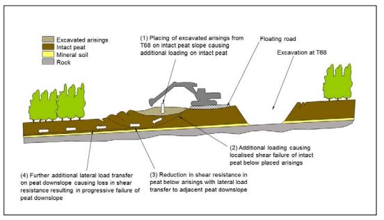
Schematic diagram from the 2020 EIA illustrating the mechanisms of the 2003 peatslide at Derrybrien in the Republic of Ireland.
.
So, it seems that the mechanism was that excavated material was emplaced on the peat adjacent to the hole. Peat is weak and has a very high water content. The emplaced material drove a localised shear failure, allowing a small landslide to develop. This then induced an additional load downslope, triggering the development of a much larger mass movement.
This appears to me to be a viable mechanism, but it also implies no retrogression occurred. This is intriguing as that was certainly not the case for the Meenbog peat landslide in November 2020. I am slightly fascinated by the hint of a failure on the upslope side of the excavation in the schematic diagram. I wonder why this was included.
It would be fascinating to see the geotechnical reports after the 2003 landslide. Does anyone know if these are available?
 Dave Petley is the Vice-Chancellor of the University of Hull in the United Kingdom. His blog provides commentary and analysis of landslide events occurring worldwide, including the landslides themselves, latest research, and conferences and meetings.
Is it that there would almost certainly be some deformation up slope when a deep excavation like that is performed in peat? I’m no geotechnical expert but around here in Sydney a lot of excavations are started with piles to form curtain walls or stabilise the slope, but those are often in sand or mud.
Peat – so tricky. California’s Delta SW of Sacramento is underlain by it and it consistently poses a challenge because of this property. I was 8 in the severe winter of 1964/65, and there were several breaches of the old un-engineered levees, and several islands flooded. The US Army Corps of Engineers tried to plug one w/many yards of rip-rap. They had to stop because the mass of the rip-rap created a classic paired shear surface, and two new islands appeared thru the floodwaters on either side of it. Fortunately, the floodwaters receded, and the repair was completed using conventional earth fill, the island pumped out.
There’s a video on Youtube taken soon after the event https://www.youtube.com/watch?v=k6UMUW4IIrc
It includes a wonderful shot of trees being carried across a local road on the flowing peat.
I worked for the company asked by Eirgrid to investigate the slide and this is the reference for the report. I didn’t prepare the report, don’t have a copy and no longer work for Agec – indeed they’ve been taken over.
AGEC (2004) Reports on Derrybrien Windfarm: Final Report on Landslide of October 2003 / Final Report on Post-Landslide Site Appraisal. Unpublished Report for ESBI.
Sorry I can’t be more helpful. I understand the report was used to prepare -https://www.gov.scot/publications/peat-landslide-hazard-risk-assessments-best-practice-guide-proposed-electricity/pages/6/
These references maybe helpful as they include the work on Derrybrien
Boylan, N., Jennings, P., Long, M., 2008. Peat Slope Failure in Ireland. Quarterly Journal of Engineering Geology and Hydrogeology, 41, pp93-108.
Long, M., Jennings, P. and Carroll, R. (2011) Irish peat slides. Landslides, 8(3), pp391-401.
A sheet of wet peat is weak and a very poor transmitter of stress. Think of a layer of set custard on a floor. Stressing such a weak layer on its edge by any method will not move it and will simply deform it at its edge. But if the entire sheet is tilted and is gravitationally metastable such an edge deformation may indeed set off a progressive mass movement downslope and upslope, most likely with subsequent fluidisation. But the edge effect will clearly not move any significant portion of a weak sheet that is not already gravitationally metastable. Another way of putting this is that any earth movement is primarily a response to a body force – gravity in this case – and not to edge effects.
For this reason it seems facile of some of the Derrybrien reports to point to localised and relatively minor edge loading as the primary cause of a much larger gravitationally driven earth movement – the edge effects were merely a trigger of what was inevitable on a longer timescale due to growth of the bog. This tendency is very much accelerated if the weak sheet of peat is sliced up by for tree planting and then progressively loaded on a shorter timescale by the growth of trees; a sitka spruce plantation in this area could add 15 tonnes per ha per year in log weight alone. This progressive loading of peat is a question for anyone growing trees on sloping blanket bog to consider.
I don’t think there is any proof that bog growth leads to failure.