16 January 2023
A remarkable number of landslides in California
A remarkable number of landslides in California
California has suffered a succession of “atmospheric river” rainfall events in recent weeks, bringing flooding and landslides across a wide area. The level of disruption to some parts of the state has been high.
Others are providing far better insight into these events than can I, so I shall point to some useful resources. First, the California Geological Survey and the USGS have been mapping the landslides as they occur, and yesterday tweeted a map of the distribution of reported events:-
1/15 UPDATE: @CAGeoSurvey and the @USGS, in support of the Governor’s Office of Emergency Services (@Cal_OES), continue mapping reported landslides every day. We are now at 402 slides statewide (& counting) since 12/30/22!#landslide #AtmosphericRiver #emergencyresponse pic.twitter.com/qZR3WwRl5p
— California Geological Survey (@CAGeoSurvey) January 15, 2023
.
This data is available in an online GIS tool, with information about each event and its impact. In many cases there is photograph available. Some of the events are spectacular:-
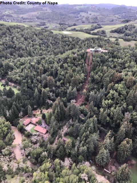
A landslide at Redwood Road, Napa County, California. Image by the County of Napa.
.
The distribution appears to be related to upland areas with active deformation from faulting. Interestingly, The Colombia Climate School has an excellent article about this rainfall event, which includes this NOAA map of the rainfall distribution up to 11 January 2023. It is instructive to compare the two maps:-
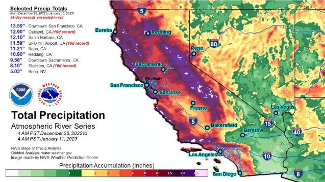
NOAA map of the distribution of precipitation in California from 26 December 2022 to 11 January 2023.
.
Meanwhile, AP has a really good article about the landslides being triggered by this seemingly unrelenting series of storms. It highlights the complex nature of landslide hazard in California, including the young geology, the impacts of prolonged drought and of course these remarkable rainfall events. As always we should remember that hazards can be natural, but disasters are human.
Inevitably, some good videos have emerged. This one occurred last week in Fresno County:-
A California Highway Patrol officer captured incredible footage of a huge landslide in Fresno County Monday afternoon. #CAwx #AtmosphericRiver https://t.co/Wqcngxk5Ea pic.twitter.com/h0bNiB8Qo3
— AccuWeather (@accuweather) January 10, 2023
.
Whilst this one occurred near Pescadero:-
Wild video of a slide continuing at partial road collapse near Pescadero.
This is at 4100 block of Stage Road.
(Vid from @CALFIRECZU)pic.twitter.com/pi7HgbZNXp— Ian Cull (@NBCian) January 14, 2023
.
Particularly interesting landslides include this one, on the Big Sur Coast:-
Big Sur Coast: Crews continue to respond at numerous locations on #Hwy1 which are showing significant instability as a result of ongoing rain event. New slide covering roadway appeared last night just south of Mill Creek. Crews are being mobilized in advance of clearing weather. pic.twitter.com/5UeuFDchov
— Caltrans District 5 (@CaltransD5) January 15, 2023
.
And, saving the best to last, this landslide occurred to the northwest of Santa Clarita:-
Castaic: on northbound I-5 the two right lanes are closed from 3 miles south of Templin Highway to Templin Highway due to a large slope slide. Unknown duration. Contractor is on scene maintaining closure. Updates at https://t.co/O37QesJHpw. Please #BeWorkZoneAlert. pic.twitter.com/HJT7U8qFSF
— Caltrans District 7 (@CaltransDist7) January 14, 2023
13 January 2023
Joshimath: ISRO InSAR data reveals the scale of the issue
Joshimath: ISRO InSAR data reveals the scale of the issue
In the last 24 hours there has been a significant development in our understanding of the landslide problems at Joshimath in northern India. Yesterday, the ISRO had released a document that provides the results of two sets of InSAR analyses for the town. This was made available on the NRSC website, but frustratingly (and slightly bizarrely) it now seems to have been removed. There are images from that report on several news channels in India though, so its disappearance is quite weird.
One analysis examined deformation in the Joshimath area between April and November 2022, showing about 9 cm of movement over the seven month period. This is the resulting diagram:-
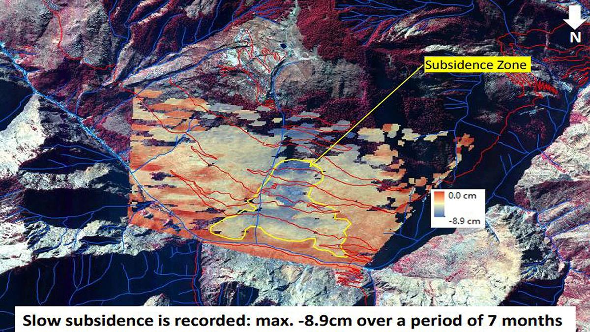
ISRO InSAR map of deformation at Joshimath over a seven month period to November 2022.
.
The second analysis examined deformation between 27 December 2022 and 8 January 2023:-
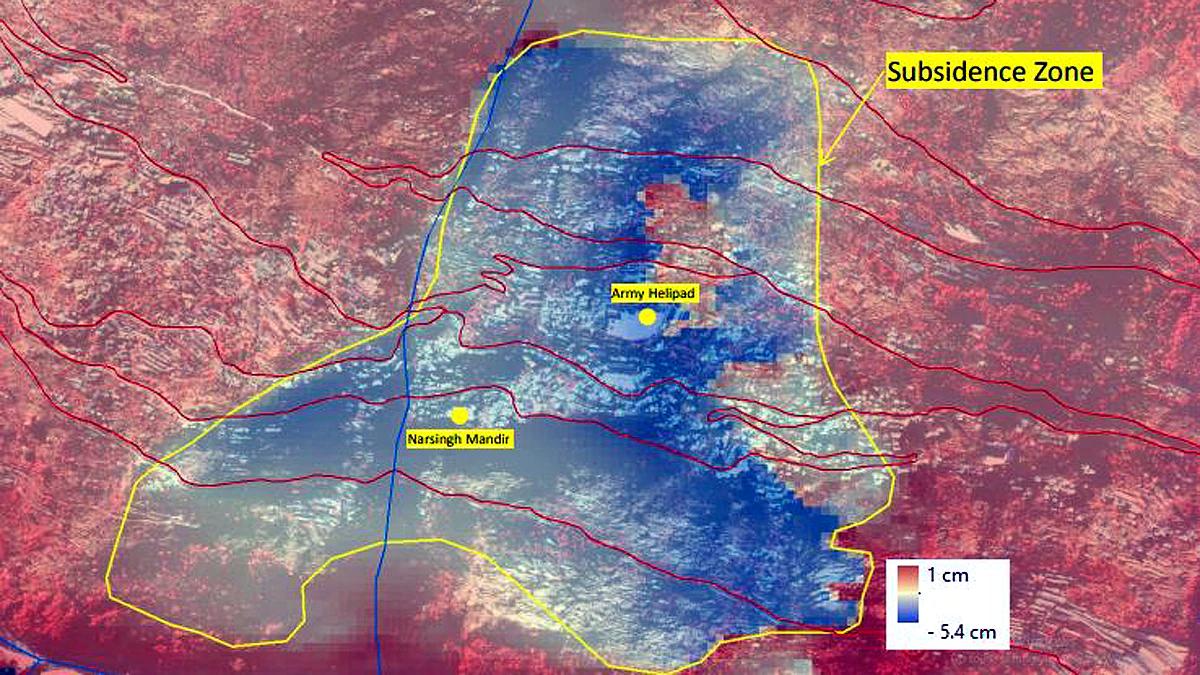
ISRO InSAR map of deformation at Joshimath over the period from 27 December 2022 to 8 January 2023.
.
Now, I think it is important to put three caveats on this analysis. First, InSAR measures line of sight movement, not absolute deformation. Thus, to interpret the data properly it is essential to understand the line of sight but, with the document no longer available, this is not clear. Second, this is labelled as subsidence, but that is potentially misleading. The movement is clearly landslide movement, and so is likely to be parallel or subparallel to the slope (whereas subsidence might be interpreted as being vertical). Third, the magnitudes of deformation do not seem to conform to observations on the ground. Whilst not trivial, 5.4 cm of movement is insufficiently large to cause the damage seen. Images such as the one below suggest deformation that is much greater than this:-
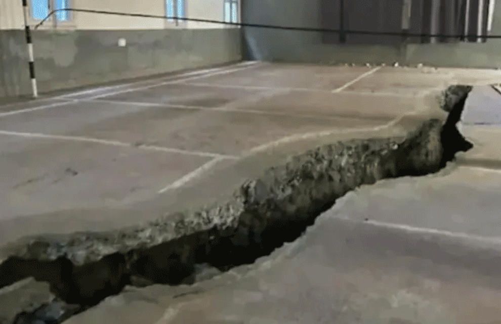
A tension crack at Joshimath. Image by The News Himachal.
.
I am unsure as to the cause of this anomaly – it could be the line of sight issue noted above, or the consequence of an initial analysis, or maybe the largest deformations occurred before 27 December.
However, the analyses provide key information. This appears to be a conventional landslide, almost certainly a reactivation of a part of the existing relict failure. The landslide is affecting the main part of the town, and extends close to the toe of the slope (the InSAR data may be unreliable in the very steep sections of slope close to the river). This might indicate that an element of the issue is toe erosion, raising the intriguing prospect that the Chamoli debris flow might have played a role. Some of the worst affected buildings, such as the two hotels that are being demolished, appear to be in the area of the lateral scarps. This is common.
The fact that the landslide is affecting the town and not the surrounding areas might hint that local factors – slope cutting, poor water management, inadequate engineering – could be playing a key role in the instability.
Of course the most important implication is that many properties at Joshimath are at risk. There are reports that the problem is continuing to get worse, with 723 buildings now considered to be unsafe.
Finally, there is a very interesting proposed paper on the NHESS website (Sundriyal et al., for comment 2023), submitted in late December, that considers the problems at Joshimath. This paper is open for comments. The paper highlights the state of instability and indicates that large amounts of deformation (in the order of metres) are possible. If this were to occur then a very large number of buildings in the town will be lost.
.
Reference
Sundriyal, Y., Kumar, V., Chauhan, N., Kaushik, S., Ranjan, R., and Punia, M. K. in review 2023. Brief communication on the NW Himalayan towns; slipping towards potential disaster, Natural Hazards and Earth System Sciences [preprint], https://doi.org/10.5194/nhess-2022-296, in review.
11 January 2023
Rosas in Cauca, Colombia: a truly extraordinary landslide
Rosas in Cauca, Columbia: a truly extraordinary landslide
This is a truly extraordinary period for landslides, with so many events occurring that it is hard to decide which to cover. In India, the Joshimath landslide is continuing (rightly) to gain a lot of attention as the situation continues to deteriorate. Demolitions are underway, but are being fiercely opposed by local residents. There remains a complete lack of clarity as to the technical situation, which will be causing considerable distress. This is a abject lesson in poor communication by the authorities.
It is reported that the number of affected properties has now reached 723. Unfortunately there is some rainfall in the area, which could exacerbate the situation.
Meanwhile, California is being struck by a series of atmospheric river events, with serious impacts There are some amazing landslide videos on Twitter.
Meanwhile, in Colombia a truly remarkable landslide has occurred in Rosas, Cauca. There are some excellent Tweets providing detail, including this one containing drone footage of the slide:-
https://twitter.com/Yobanygf/status/1612967281536933889
.
This landslide, which started to develop on 6 January 2023 but fully failed on 9 January 2023, has destroyed the communities of Parraga Viejo, Santa Clara, La Soledad and Chontaduro. It is reported that 64 homes have been destroyed, rendering 164 families and over 700 people homeless. The landslide has also closed over 500 metres of the Pan American Highway between Popayán and Pasto.
The best image I have found is this one, which was tweeted by Christian Mejia:-
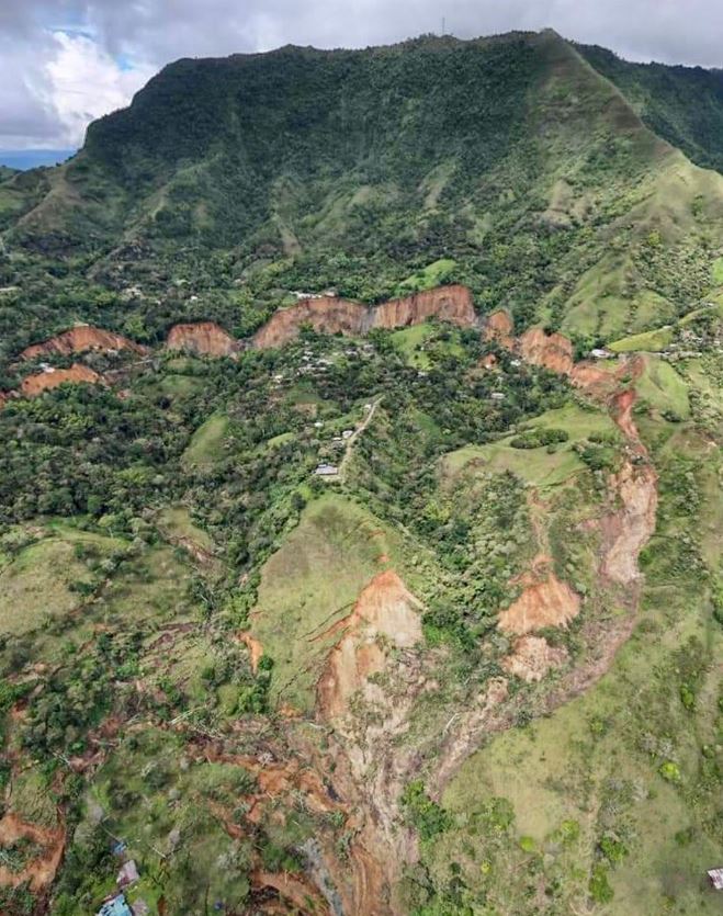
The 9 January 2023 landslide at Rosas at Cauca in Columbia. Image tweeted by Christian Mejia.
.
The location of the landslide is described in a tweet by Willian Burbano:-
https://twitter.com/wilbuz/status/1612628816014237696
.
The coordinates of the Rosas landslide are 2.249, -76.779. The ever reliable Helbert Schneider has tweeted some background information about the landslide:
The material involved is highly weathered Pliocene tuffs of the Galeón Fm. In this area, a soil avalanche killed 33 people on April 21, 2019.
— Helbert García-Delgado (@HelbertSchneid1) January 10, 2023
.
Plans are underway to purchase the land from the affected families, allowing them to relocate, whilst humanitarian assistance is being provided as an interim measure.
8 January 2023
Joshimath: a complex landslide environment
Joshimath: a complex landslide environment
In India, the issues with the landslides at the hilltop town of Joshimath continue. There are a variety of narratives about the situation, ranging from those seeking to downplay the severity of the landslides to those expressing concerns that the situation could escalate quickly. There is also massive speculation about the likely causes of the ongoing movement.
Some aspects seem to be under little dispute. First, there is clearly substantial movement occurring in some parts of the complex. Second, that a survey last week identified 561 properties with severe cracks, with some information about the distribution of these by ward. For example, the Deccan Herald reports that:
So far, 561 houses in different areas of the town have developed cracks, including 153 in Ravigram, 127 in Gandhinagar, 71 in Manoharbagh, 52 in Singhdhar, 50 in Parsari, 29 in Upper Bazar, 27 in Suneel, 28 in Marwadi and 24 in Lower Bazar, District, District Disaster Management Officer NK Joshi said.
Two hotels are so seriously damaged that they have had to be evacuated – these are the Hotel Mount View and the Malari Inn, which I think are located about 1,300 metres apart. A key temple, Jyotir Math, has also developed severe cracks over the last 15 days. There are also reports of cracks along roads and in fields, and the adjacent town of Auli, a skiing resort, is also reported to be suffering from stability issues.
The situation is sufficiently serious that the Prime Minister’s Office is convening a meeting to discuss the problems today.
The geological and social setting for these landslides is very complex. It is clear that the site is an ancient landslide complex that is probably marginally stable. There is little doubt that aspects of the development at Joshimath has been suboptimal, with a lack of consideration at times of drainage and of appropriate excavation. The image below is quite instructive – these are examples of large retaining walls showing very obvious distress:-
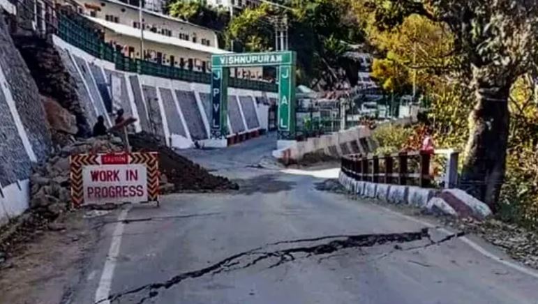
Deformation in retaining walls at Joshimath. Image from the Hindustan Times.
.
But additionally there is speculation about the role of the tunnels for the Tapovan hydroelectric scheme – which was severely damaged two years ago in the Chamoli disaster – which are below Joshimath. One area of speculation is that the tunnels have changed the hydrology of the mountain, causing the failures. Whilst some hydrological changes may well have occurred, in general I would expect that the tunnels would cause dewatering of the mountain, which is unlikely to induce instability, although this is speculation on my part. The other is that blasting for the tunnels has triggered instability. The distances seem quite large for this, but perhaps topographic amplification might have played a role? Other alternatives include dewatering causing compaction of the materials forming the mountain, or subsidence associated with poor control of the tunneling causing stress changes in the mountain. This needs detailed investigation.
The causes of most landslides are complex, and it is very likely that this will be the case here. It is probably unwise to blame a single element for what is happening. It is likely to be a combination of multiple factors, acting in concert. Lessons need to be learnt of course, but for now there needs to be focus on a range of timescales, all starting without delay:
- In the very short term, assistance is needed to those being impacted by the landslides. Many families and businesses are likely to be displaced – they need urgent support. This is immediate but will also be a long term need;
- In the short to medium term, attempts need to be made to try to reduce the rate of movement. This is likely to need to focus on drainage and on support for the slope. Meanwhile, there is an urgent need to map out the signs of deformation on the buildings and other structures, and on the ground. This mapping will allow an understanding of which parts of the landslide complex are moving.
- In the medium term a proper ground investigation is needed. This will allow…
- …A long term plan for the stabilisation of the site.
Of course in the interim no new construction should be allowed, and it would be prudent to avoid any blasting. There maybe a case for ceasing all tunneling works in the area.
There are no quick fixes at Josimath, but urgent action is needed.
Finally, is anyone able to process InSAR data for the site? I think this might tell us a great deal.
4 January 2023
Joshimath: an Indian town with a serious landslide problem
Joshimath: an Indian town with a serious landslide problem
Joshimath is a town built in a beautiful setting on the side of a mountain in Chamoli District in Uttarakhand in northern India. Located in the same district as the 2021 Chamoli landslide and debris flow, this is an area with many slope stability issues. The town itself, situated at 30.553, 79.563, looks like this on Google Earth:-
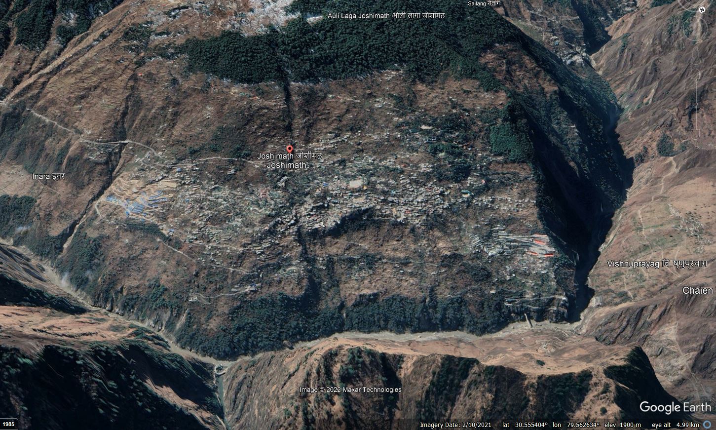
Google Earth image of the town of Joshimath in northern India.
.
A rapid inspection of the site suggests a host of underlying landslide concerns with this slope. The large scoop missing from below the town in the centre right of the image is particularly intriguing for example. History tells us that slope problems are often greatly exacerbated by urbanisation, including disruption to the drainage, the uncontrolled discharge of water and undercutting of slopes.
Over the last few days, a number of media outlets in India have run stories about the scale of the landslide issues that are occurring at Joshimath, and the rate at which they are developing. For example, PKB News has quite a detailed story about the impacts of the slope failure. Their story notes the scale of the problem:
In Joshimath of Uttarakhand, people are in panic as cracks have appeared in around 559 houses. Due to the landslide, not only the houses, but also the roads along with the hotels and hospitals present there have been cracked.
The Times of India has a set of photographs of the catastrophic damage that is occurring to buildings in Josimath, whilst the PKB News story is illustrated with this image:-
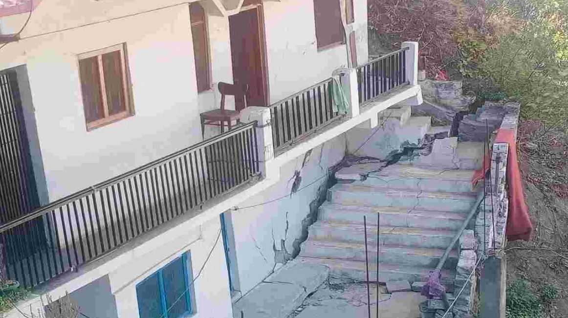
Landslide damage in Joshimath, northern India. Image from PKB News.
.
Interestingly, the Times of India reports that an investigation in 1976 reported that the town is built upon an ancient landslide, and that the long term prognosis was poor.
Clearly there is an urgent need to investigate the hazards at Joshimath, and to develop a plan to manage the hazard. Reports indicate that a survey of damaged properties is under way, but this needs to be a part of a major larger investigation. Unfortunately, managing a landslide on this scale is likely to be very expensive.
It is of course worth noting as well that this is an area of significant seismic hazard, so the potential behaviour of these slopes during a major shake should also be factored in.
23 December 2022
Losses from debris flows in Brazil
Losses from debris flows in Brazil
It is well-established that Brazil has a substantial problem with landslides, most notably in the urban areas in the southeast of the country. An Open Access paper just published in Landslides (Cabral et al. 2022) provides a detailed analysis of one type of landslide in the country, debris flows. The paper looks at recorded events in the period between 1920 and 2021 inclusive.
In total, the authors have documented 45 debris flow events over this period in Brazil, causing 5,771 fatalities and US$5,5 billion in economic losses. The most serious events occurred on 11 January 2011 in the vicinity of Rio de Janeiro, when heavy rainfall triggered three separate debris flows that killed a total of 892 people. But very large events have occurred at other times. For example, on 18 March 1967 a debris flow at Caraguatatuba, Sao Paolo killed 436 people, and on 19 February 1988 a debris flow in Rio de Janeiro killed 289 people.
In 2010 a debris flow triggered within a deactivated landfill area in Niterói killed 48 people and left a further 221 missing. There is a contemporary report on this event in the San Diego Union Tribune, which includes this image:-
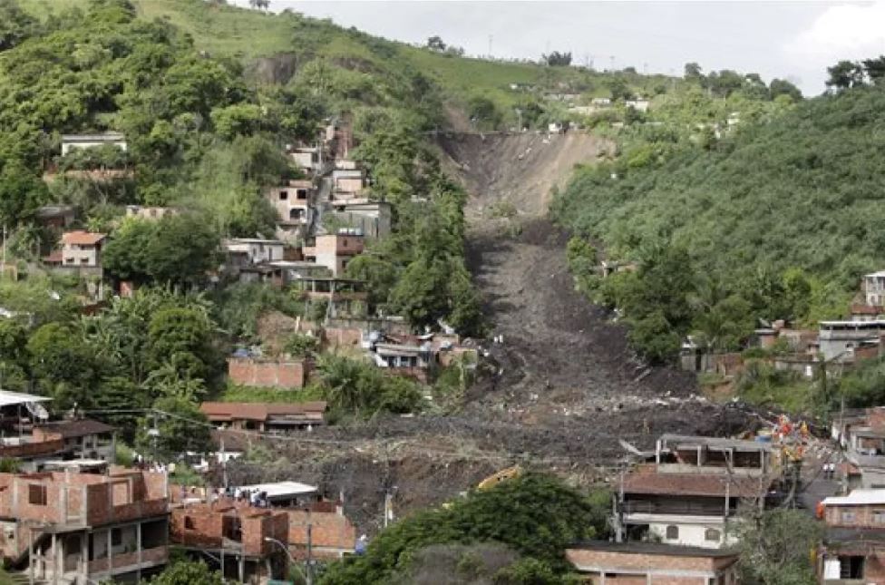
The aftermath of the 1988 landslide at Niteroi in Brazil. Image by AP Photo/Felipe Dana via the San Diego Tribune.
.
Perhaps the most interesting aspect of this study is the analysis of events and losses through time. (Cabral et al. 2022) report the following:
There has not been a significant increase [in the number of events] in recent decades, with the frequency averaging at about seven per decade since the 1960s. Prior to 1960s, the documentation of debris-flow events is scarcer, which can be associated to lower levels of urbanization and, consequently, a lower societal impact. The number of fatalities along the years has also been steady since the 1960s, with the decades of 1960s and 2010s standing out as those with the highest number of fatalities, particularly in the years of 1967 and 2011. These two years are characterized by the high-magnitude debris-flow events in Caraguatatuba and Serra das Araras (1967), and Teresópolis, Petrópolis and Nova Friburgo (2011).
On the other hand, economic losses have accelerated dramatically, probably related primarily to increased urbanisation and economic activity, meaning that more assets with a higher value were in the path of debris flows.
Cabral et al. (2022) conclude the abstract with the following, which is hard to deny:
…these results highlight the urgent need for investments in disaster prevention and preparedness programs.
.
Reference
Cabral, V., Reis, F., Veloso, V. et al. 2022. The consequences of debris flows in Brazil: a historical analysis based on recorded events in the last 100 years. Landslides. https://doi.org/10.1007/s10346-022-01984-7
21 December 2022
The Urni landslide: a recurring slope failure in India
The Urni landslide: a recurring slope failure in India
On Monday 19 December 2022 a significant slope failure occurred at the Urni Landslide in Kinnar, Himachal Pradesh in northern India. This event was notable for the fact that it was caught on camera by users of National Highway 5, which passes close to the landslide site:-
.
Fortunately there was no loss of life at this site, but the road was closed for repairs.
The landslide is located at 31.519, 78.129 on the banks of the Sutlej River in very steep terrain. It is captured beautifully in Google Earth:-
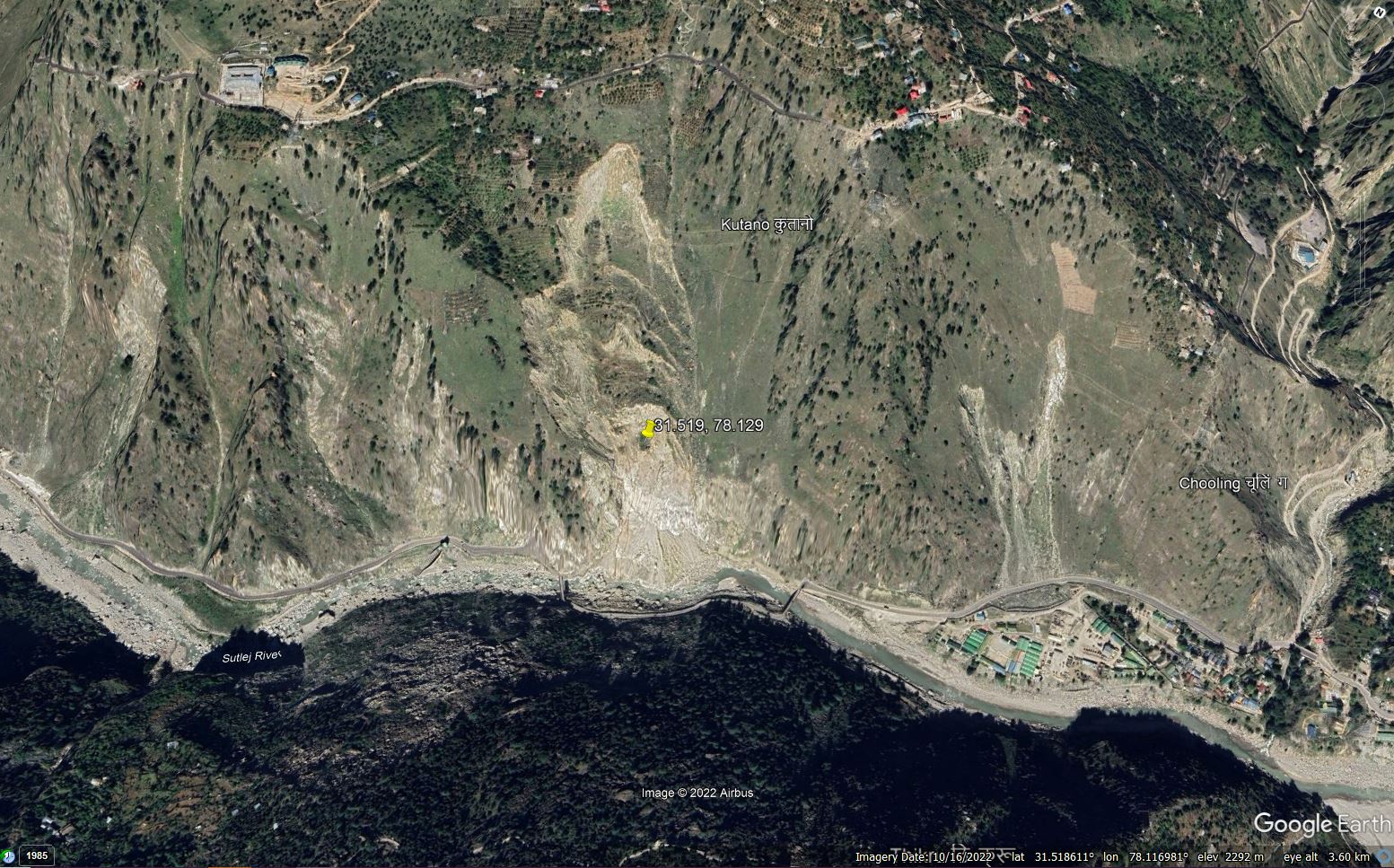
Google Earth image of the Urni landslide in Kinnaur, India.
.
The archive images of the site on Google Earth provide a classic case study of the development of a landslide through time – take a look. The slope is now deeply problematic – note the very the diversion of the road across to the other bank of the river for a short section to try to avoid the landslide toe/
The Urni landslide was written up in an open access paper (Kumar et al. 2019) that was published in the journal Geoscience Frontiers. The aim of the paper was to model a major failure that might dam the river. The authors noted that the landslide has developed in gneissic rocks on steep slopes, and that there are numerous cracks upslope of the existing failure, indicating a high probability of future events. This came to pass this week, at least in part. The failure was initially a structurally-controlled wedge failure, but has developed into a much more complex landslide.
Movement is primarily triggered by heavy rainfall in the monsoonal climate, but the precarious nature of the topography inevitably means that collapses can occur at any time.
Of interest at this site is the ongoing works to construct the Karcham Wangtoo Hydro Power Project – some elements of this are visible in the image above. It has long been asserted that these works have led to an increase in the occurrence of landslides in this area. For example, the South Asia Network on Dams, Rivers and People has an article from 2014 documenting some of the impacts. Construction started in 2005.
Of course, of immediate concern is the potential risk to the houses upslope of the Urni landslide. In October 2022 the crown of the landslide was perilously close to the houses. A major failure could exacerbate this situation.
.
Reference
16 December 2022
A major, deadly landslide in Genting Highlands, Malaysia
A major, deadly landslide in Genting Highlands, Malaysia
On this, the 15th anniversary of the Landslide Blog, there is tragic news of a major landslide in the Genting Highlands of Malaysia. The situation remains dynamic as I write, but it is clear that the landslide inundated a campsite at a location known as Father’s Organic Farm. News reports indicate that there were 81 people registered to stay at the site, 30 of whom were children, plus of course a number of staff. In total 53 people have been reported to have been rescued. As I write, there are 16 confirmed fatalities, with a further 17 believed to be missing. These numbers will change in the coming hours.
There are some videos on Twitter collected via drones showing the configuration of the landslide. These videos in particular are revealing:-
https://twitter.com/BernamaTV/status/1603587971374280704
.
Based on these videos I believe that the site of the landslide is at 3.423, 101.757. This is my interpretation of the location on Google Earth:-
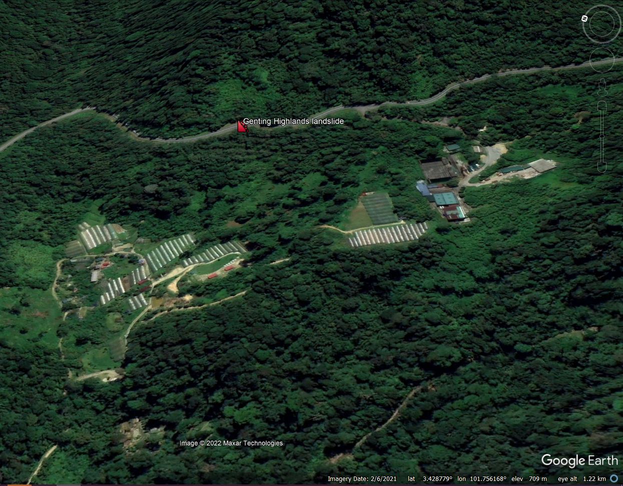
Google Earth image of my interpretation of the site of the 16 December 2022 landslide at Genting Highlands in Malaysia.
.
The landslide occurred at 2:42 am, which sadly will have amplified the human cost of the disaster – to be in tents that are struck by a high mobility landslide in the dark is true horror.
There is already considerable speculation in Malaysia about the likely causes of this tragedy. I suspect that there might be a hint in the archive of Google Earth images, although I can only hypothesise at this point. This image, from 2002, is extremely interesting. As above, I have marked the site of the landslide:-
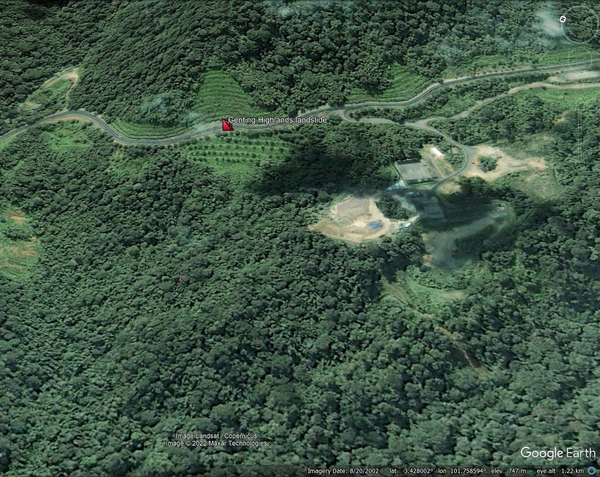
Archive Google Earth image, from 2002, of my interpretation of the site of the 16 December 2022 landslide at Genting Highlands in Malaysia.
.
It appears to me that the slopes both above and below the road have been engineered. The videos indicate that the slope above the road remains intact, but the slope below the road has failed. The 2002 Google Earth image would seem to indicate that the slope was terraced. I wonder if this was a fill slope, and that the fill has failed to generate the landslide. This would explain the location, the dynamics and the impact of the landslide.
The second element that is interesting is from a 2018 Google Earth image, although the quality is not great:-
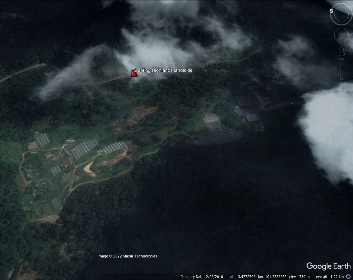
Archive Google Earth image, from 2018, of my interpretation of the site of the 16 December 2022 landslide at Genting Highlands in Malaysia.
.
In this image there appears to be bare soil at or close to the toe of the postulated fill slope. It is not clear to me as to what was happening at this time – in subsequent images this area has revegetated, but this needs investigation.
JKR Malaysia Slope Engineering branch has responsibility for analysing these types of events, and a team is reported to be on site today. I am sure we will see a full interpretation of the causes of this landslide in due course. Meanwhile, the recovery work will continue, but sadly the likelihood of further successful rescues seems low.
.
Acknowledgement
Thanks to Riza and Liew SS for their kind emails pointing to information about the landslide at Genting Highlands.
Fifteen years of the Landslide Blog
Fifteen years of the Landslide Blog
Today marks the 15th anniversary of my first post to the Landslide Blog. I find it hard to believe that it has been so long. My first post was on 16 December 2007, when I posted about the La Honda landslide in California (see image below), based on a field visit with Nick Rosser, who was working with me as a post-doctoral researcher at Durham University (Nick is now a professor at Durham). Today’s post is number 2,470 on this blog, which works out at about 164 per year. The blog started out on blogger but after a few years moved over to the AGU Blogosphere. I have been hugely honored to have been hosted by the AGU, who have been immensely generous to me.
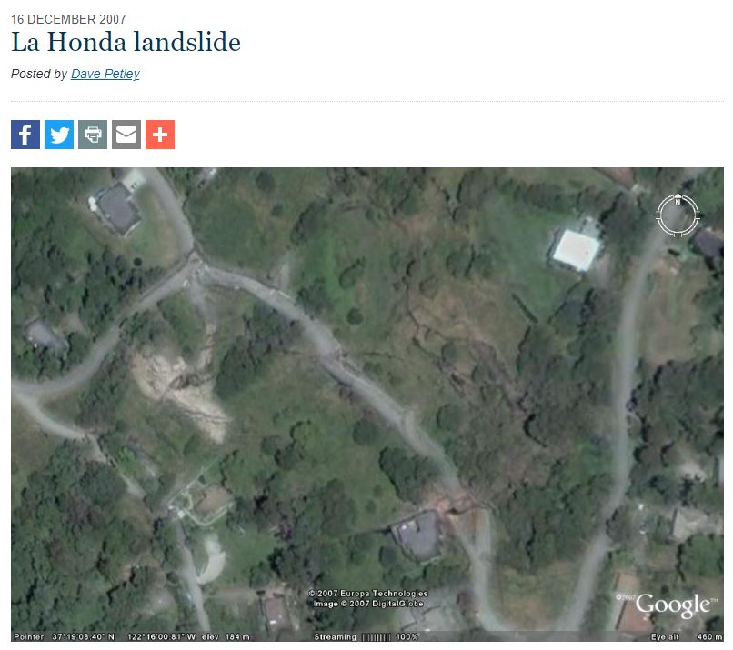
My first ever blog post, 15 years ago
.
The site still receives around 1,000 individual visits per day on average, although this fluctuates greatly. It has evolved with time – my posts tend to be a little longer now, and I benefit greatly from the support of many people around the world who provide information about landslides in their domain. I’m not always able to respond as much as I would like, but thank you to you all.
Over the years I have focused on some specific landslide events – in 2008 for example I wrote a great deal about the Wenchuan Earthquake, in 2010 about the Attabad landslide. I have developed some recurring themes – tailings dam failures, the rapidly evolving ability of satellites to allow rapid assessment of failures, landslides associated with major dams, and the horror of mining landslides, especially in Myanmar, for example.
Along the way I have only really had two bad experiences, both of which have been associated with senior and well-respected landslide scientists. Whilst those interactions were shocking and disturbing in many ways, the rest of my interactions have been a huge pleasure and a privilege.
Over the 15 years of this blog my day job has changed hugely. At the start I was a Professor at Durham University, and in the later stages I was also Dean of Research there. In 2014 I moved to become Pro-Vice-Chancellor (Research and Enterprise) at UEA, then in 2016 I became Vice-President (Research and Innovation) at the University of Sheffield. In September 2022 I moved again, to become Vice-Chancellor at the University of Hull, which is my role today. The blog has been a constant through this period, and has allowed m to remain rooted to my discipline.
Even with my current somewhat busy schedule I plan to maintain the blog, even as many others that started at the same time have fallen away. I write it very early in the morning, at the start of my day, as a way to get my brain in gear. I hugely appreciate spending time thinking about my research focus, even though I rarely have time for research itself. Of course my pieces on individual events are only ever an initial take; the definitive accounts result from detailed studies by others, and must always be seen as being more important.
I write about things that interest me, making the topics somewhat eclectic. I’m constantly amazed and delighted that others find them to be of interest. I will continue to do so if and when I can.
So, finally, thanks to you all for the last 15 years, and thanks in particular to the AGU, to LarryO’, to Planet Labs and to many others for your kind help.
15 December 2022
The occurrence of landslides in Pakistan
The occurrence of landslides in Pakistan
The combination of topography, rainfall, seismicity and people means that Pakistan is heavily affected by landslides. However, until now I have not been aware of a systematic analysis of landslides at a national level in a way that has been performed for many other countries, a major gap in our understanding of this hazard. Pleasingly, a paper (Shabbir et al. 2022) has just been published in the journal Environmental Science and Pollution Research that seeks to fill in this gap. Even better, it is open access.
The researchers have compiled a dataset of landslides across Pakistan from 2003 to 2019 inclusive. The dataset includes all reported landslides, not just those that have caused fatalities (as in the case of my own research). In total, 1,089 landslides have been identified, of which 180 led to loss of life. In total, 1,072 people were killed by landslides over this period. Rainfall triggered 63% of the recorded events, although interestingly the seasonal effects that are seen in other parts of South Asia (for example Nepal) is less strong in Pakistan.
The map below shows the distribution of recorded landslides:-
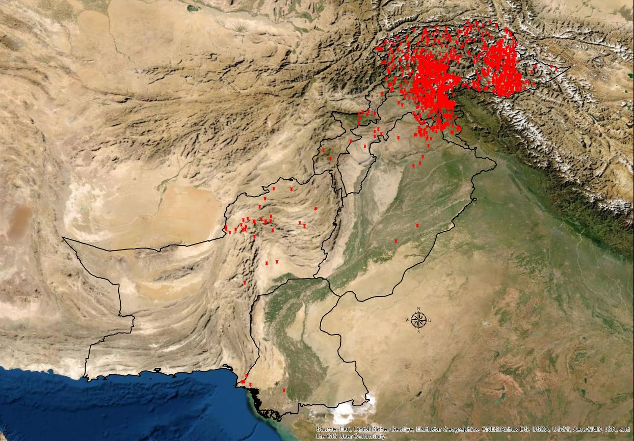
The distribution of recorded landslides in Pakistan from 2003 to 2019 inclusive. Map from Shabbir et al. (2022).
.
There is huge richness in this map. The most obvious conclusion is the immense focus of landslides on the northeast of the country, in the high mountain areas. Pakistan is particularly interesting as the Karakoram Highway means that many people live beyond the frontal range of the high mountains. This is reflected in the landslide distribution, which extends a long way to the north. But even here there are two distinct clusters, one located in the area of Muzaffarabad and associated districts, and the other in the far northeast, around Baltistan. The first cluster is at least in part in the area affected by the dreadful 2005 Kashmir Earthquake, which triggered many landslides (most of which are poorly constrained, and so are not captured in this dataset), whilst the other is the area in which the 2010 Attabad landslide occurred.
This is a really valuable study, and I commend the authors for putting it together. I would really like to see further analysis, in particular of the fatal landslides, which are likely to form a more consistent dataset. Understanding these patterns in time and space is incredibly valuable as a step towards managing the risk.
.
Reference
Shabbir, W., Omer, T. & Pilz, J. 2022. The impact of environmental change on landslides, fatal landslides, and their triggers in Pakistan (2003–2019). Environmental Science and Pollution Research. https://doi.org/10.1007/s11356-022-24291-z


 Dave Petley is the Vice-Chancellor of the University of Hull in the United Kingdom. His blog provides commentary and analysis of landslide events occurring worldwide, including the landslides themselves, latest research, and conferences and meetings.
Recent Comments