4 January 2023
Joshimath: an Indian town with a serious landslide problem
Posted by Dave Petley
Joshimath: an Indian town with a serious landslide problem
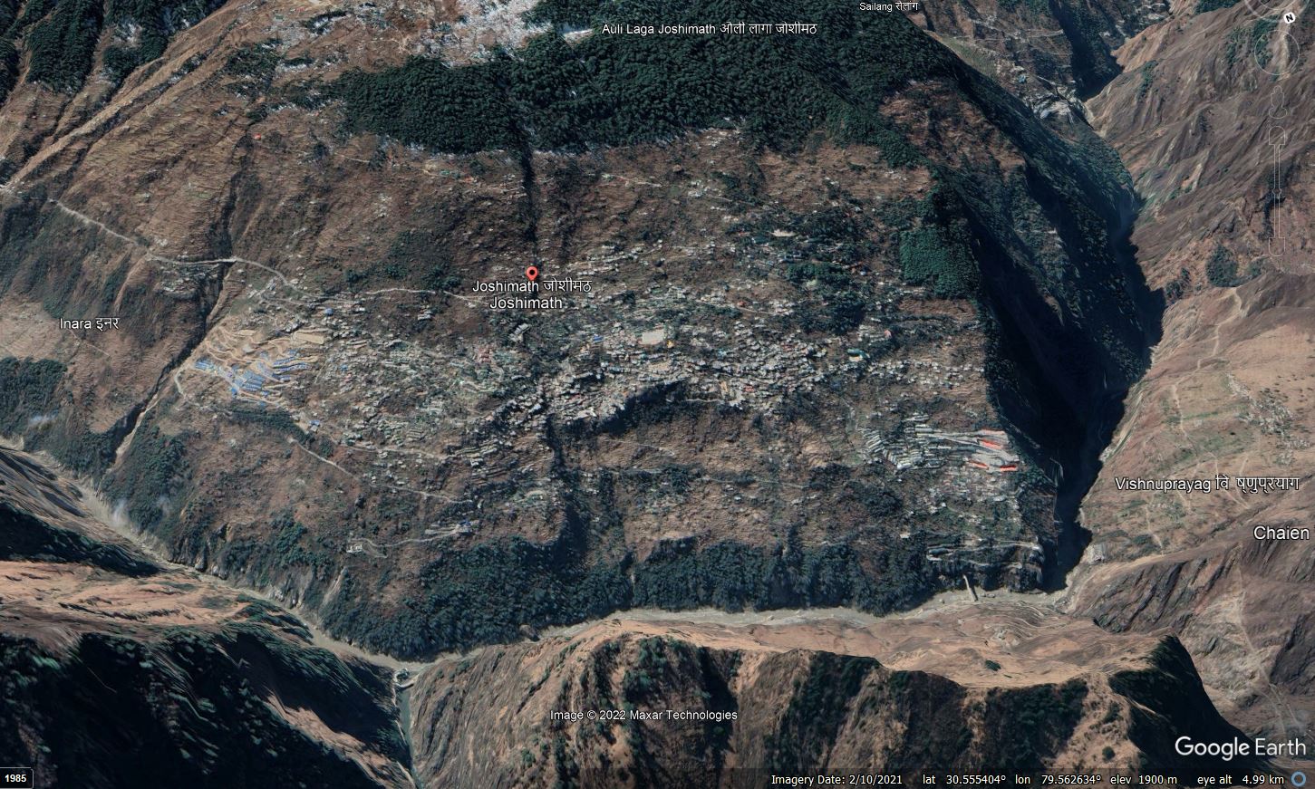
Joshimath is a town built in a beautiful setting on the side of a mountain in Chamoli District in Uttarakhand in northern India. Located in the same district as the 2021 Chamoli landslide and debris flow, this is an area with many slope stability issues. The town itself, situated at 30.553, 79.563, looks like this on Google Earth:-

Google Earth image of the town of Joshimath in northern India.
.
A rapid inspection of the site suggests a host of underlying landslide concerns with this slope. The large scoop missing from below the town in the centre right of the image is particularly intriguing for example. History tells us that slope problems are often greatly exacerbated by urbanisation, including disruption to the drainage, the uncontrolled discharge of water and undercutting of slopes.
Over the last few days, a number of media outlets in India have run stories about the scale of the landslide issues that are occurring at Joshimath, and the rate at which they are developing. For example, PKB News has quite a detailed story about the impacts of the slope failure. Their story notes the scale of the problem:
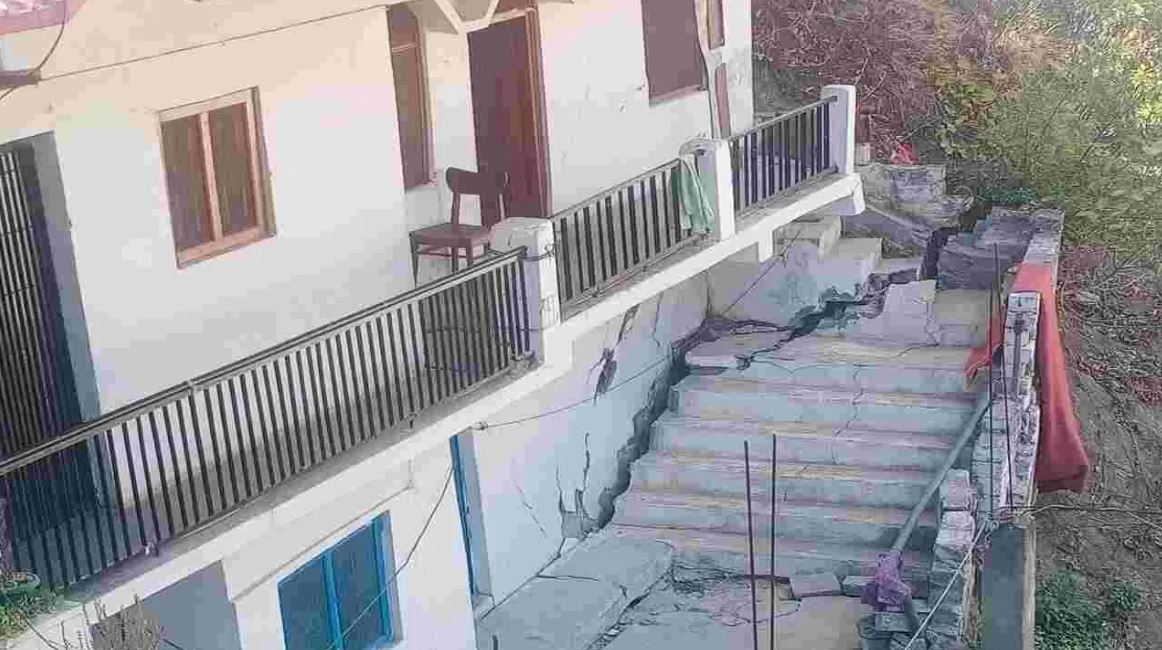
In Joshimath of Uttarakhand, people are in panic as cracks have appeared in around 559 houses. Due to the landslide, not only the houses, but also the roads along with the hotels and hospitals present there have been cracked.
The Times of India has a set of photographs of the catastrophic damage that is occurring to buildings in Josimath, whilst the PKB News story is illustrated with this image:-

Landslide damage in Joshimath, northern India. Image from PKB News.
.
Interestingly, the Times of India reports that an investigation in 1976 reported that the town is built upon an ancient landslide, and that the long term prognosis was poor.
Clearly there is an urgent need to investigate the hazards at Joshimath, and to develop a plan to manage the hazard. Reports indicate that a survey of damaged properties is under way, but this needs to be a part of a major larger investigation. Unfortunately, managing a landslide on this scale is likely to be very expensive.
It is of course worth noting as well that this is an area of significant seismic hazard, so the potential behaviour of these slopes during a major shake should also be factored in.


 Dave Petley is the Vice-Chancellor of the University of Hull in the United Kingdom. His blog provides commentary and analysis of landslide events occurring worldwide, including the landslides themselves, latest research, and conferences and meetings.
Dr Petley, did you see any media about the Snowpatch Spire rockfall in the BC Canada Bugaboo Mountains. Notable not from volume but suddenness and impacting many popular climb routes. No fatalities due to off season.
Quote from CBC article: “Drew Brayshaw, a climber and senior hydrologist and geoscientist with Statlu Environmental Consulting, said the rockfall affected about a dozen climbs. He estimates it was roughly 30,000 to 50,000 cubic metres in size.”
Unplanned urbanization with infrastructure to cater the needs of pilgrims,tourist all are responsible for the ills of not only of Joshimath but entire Himalaya.
The unprecedented subsidences in Joshimath have a long history and telltale indicators have been overlooked or ignored. The town is developed on old glacial drift deposits perched on the slopes and is incessantly undercut by the River Alaknanda resulting in the gradual erosion of the toe area. This erosion and underpinning are reflected in the form of cracks/fissures, and tilting of trees, buildings, poles, and pillars. There are documented reports on the cracks and their pattern all through the town which are exacerbated owing to urban pressure that the township is witnessing.
Prima facie is not associated with tunnel construction or any other project undertaken as tunnel excavation is confined to the rock mass and may not be related to overlying overburdened deposits. It needs a thorough examination to dispel such doubts.
As an immediate measure rehabilitation of affected communities is of utmost priority, then the demarcation of most critical areas, risk mapping, risk evaluation, and further repair or retrofit based on a sound geological assessment of the ground should be the top priority of the town. This will be a geological challenge requiring lot of cost.
-Dr. Vinod K. Sharma, Expert Engineering Geologist, and Ex Dy.D.G.,GSI
Doctor, can one of the reasons for the increase in subsidence in the town be the flood disaster of last year? The large volume of water that Alaknanda and Dhauliganga received during that event could have sped up the erosion at the toe.
[Good point, thank you. If so I would expect that local people would have observed cracks starting to form lower on the slope in the first instance, and then this problem propagating upslope with time. It will be interesting to see if this happened. D]
About Joshimuth subsidence:
Remember the area as we have seen the segmented slope areas when we were going to the field trip to the TriHari Dam. We have checked the maps of the area of devastation and found that the urban areas are developing on the foothills, composed of heterogeneous Piedmont deposits. Geologically piedmont deposits are composed of very unpredictable mixed materials. The mass strength of the Piedmont material is very erratic and simple soil investigation is not enough to understand the failure mechanism. If it is happening in the winter like this during monsoon the Joshimath area would experience server damage and destruction. It is the beginning.
Precautions: Don’t tease Himalaya which is the youngest mountain in the world. It’s layers are not well consolidated yet. Keep Himalayas as our natural heritage. It is our watchman (Choukidar )
Really I agree with this report. It is not due to human intervention. It is natural happening. It is due to the the texture of the formation rocks called Piedmont rocks. Which is highly fragile and loose its strength very quickly with water causing subsidence that is actually occuring in Joshimath. This is beginning and pray for rainy season. Be prepared for below Joshimath.
Thank you Dr. Daya Shanker for a realistic interpretation of mobile geologic materials beneath the town. We look forward to see the people of the devasted area are moved to a safer place.