
8 February 2021
The catastrophic landslide and flood in Chamoli in Uttarakhand: the sequence of events
Posted by Dave Petley
The catastrophic landslide and flood in Chamoli in Uttarakhand: the sequence of events
Deciphering the sequence of events that lead to the terrible debris flow / flood in Chamoli yesterday was quite a challenge, especially on a Sunday. However, a combination of the willingness of a number of people to use their expertise, and the availability of daily satellite imagery from Planet Labs, meant that we had the sequence determined within 8 hours of the event. This is remarkable – the landslide occurred in a very remote location, and the infrastructure was severely damaged. It took us a few days to understand the 2012 Seti landslide in Nepal, which was similar to this one. Now we can do this in a few hours.
So, for clarity, I thought it would be helpful to lay out the sequence events. I am going to lean heavily on Twitter, but these tweets come from a combination of world experts and citizen scientists. I have no doubt that this is the true story of what happened, but there are details to understand still.
1. For a few months a large failure had been developing in the high mountains
Although we did not detect it, high in the mountains at 30.339, 79.731 a large crack was developing on the flank of one of the high peaks over a few months. I believe that this is Trisul, but there is some uncertainty about the names of the peaks. It is now clear that this mountain was Nanda Ghunti. This crack was detected after the event in a sequence of Sentinel satellite images by Julien Seguinot. At the end of the sequence the unstable block is clearly visible:
https://twitter.com/pyjeo/status/1358480152682987523
.
These cracks defined the block that failed.
2. On the morning of 7 February 2021 the block collapsed in an enormous landslide
The failure of this block shows up very clearly in a satellite image collected later in the day by Planet Labs. It was first identified by Dr Dan Shugar:
https://twitter.com/WaterSHEDLab/status/1358437031802593280
.
The best view of this has been provided by Scott Watson:-
3D rendering of @planetlabs image collected 7th Feb showing the source of the Uttarakhand disaster located by @WaterSHEDLab. Appears to be a complete detachment of a previously glaciated slope #Chamoli #Disaster #Landslide pic.twitter.com/SElrZh36kH
— Scott Watson (@CScottWatson) February 7, 2021
.
The 3D diagram shows the events brilliantly. The block of rock, with some ice, dropped from about 5,600 m to about 3,800 m, a fall of almost two kilometres, before impacting on the valley floor. It will have instantly fragmented to generate a huge rock and ice avalanche, which travelled down the glacier. This would have been extremely fast and very energetic. On the way it generated a vast quantity of dust, which is smeared on the valley side to the west of the glacier valley.
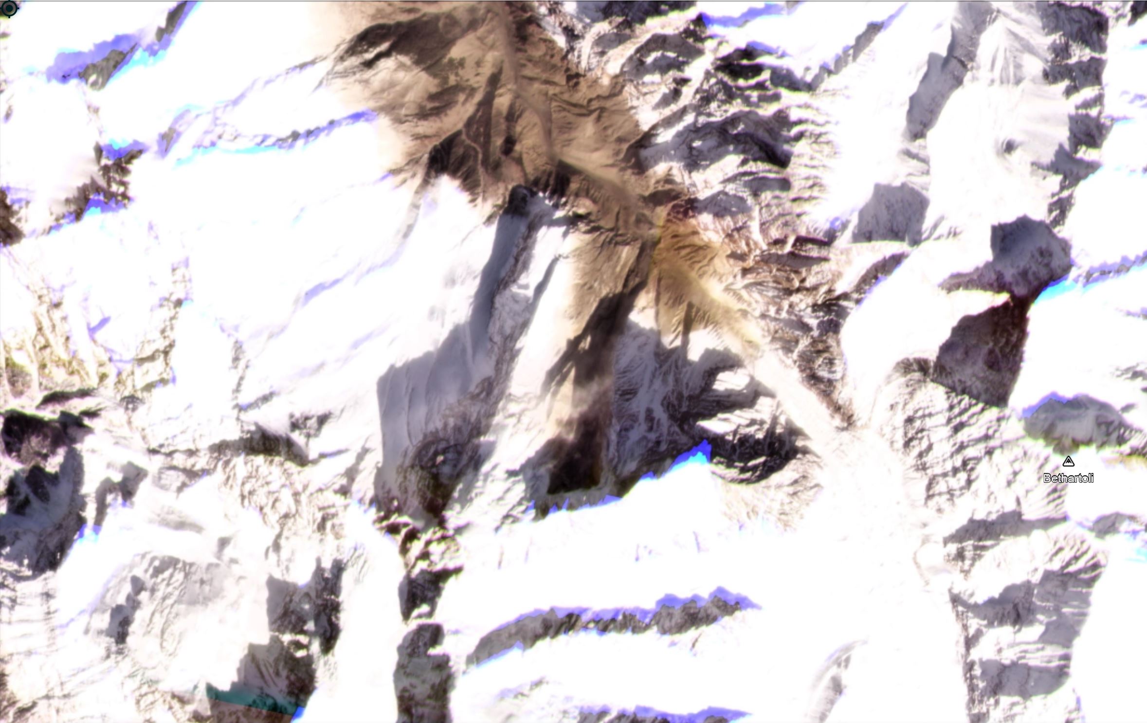
The landslide from Trisul that caused the Chamoli debris flow and flood. Image copyright Planet Labs, used with permission.
.
3. The landslide entrained stagnant ice and glacial debris
Down valley (to the north) the rock avalanche was able to entrain a vast amount of water and sediment. The most likely source for this was identified by Matt Westoby:
It's late, and I'm squinting, but looks to be ~3.5km-worth of stagnant glacier/ice-cored moraine downstream of the point where the avalanche hit the valley floor. If so, there's your source of additional water for flow bulking. pic.twitter.com/cuGMRCxXGC
— Matt Westoby (@MattWestoby) February 7, 2021
.
It seems likely that much of this material was the remains of previous landslides and some glacial material. The rock avalanche will have generated a huge amount of heat and will have induced fragmentation. The ice will have been entrained into the flow, crushed and melted, allowing the landslide to transition to a debris flow. The volume will have continued to increase as the landslide rushed to the north.
.
4. The flow followed the valley to the west, and struck the populated areas
The Planet Labs images show that the landslide swung round to the west, and raced down the valley. The Planet Labs image below, taken shortly after, shows the aftermath:-
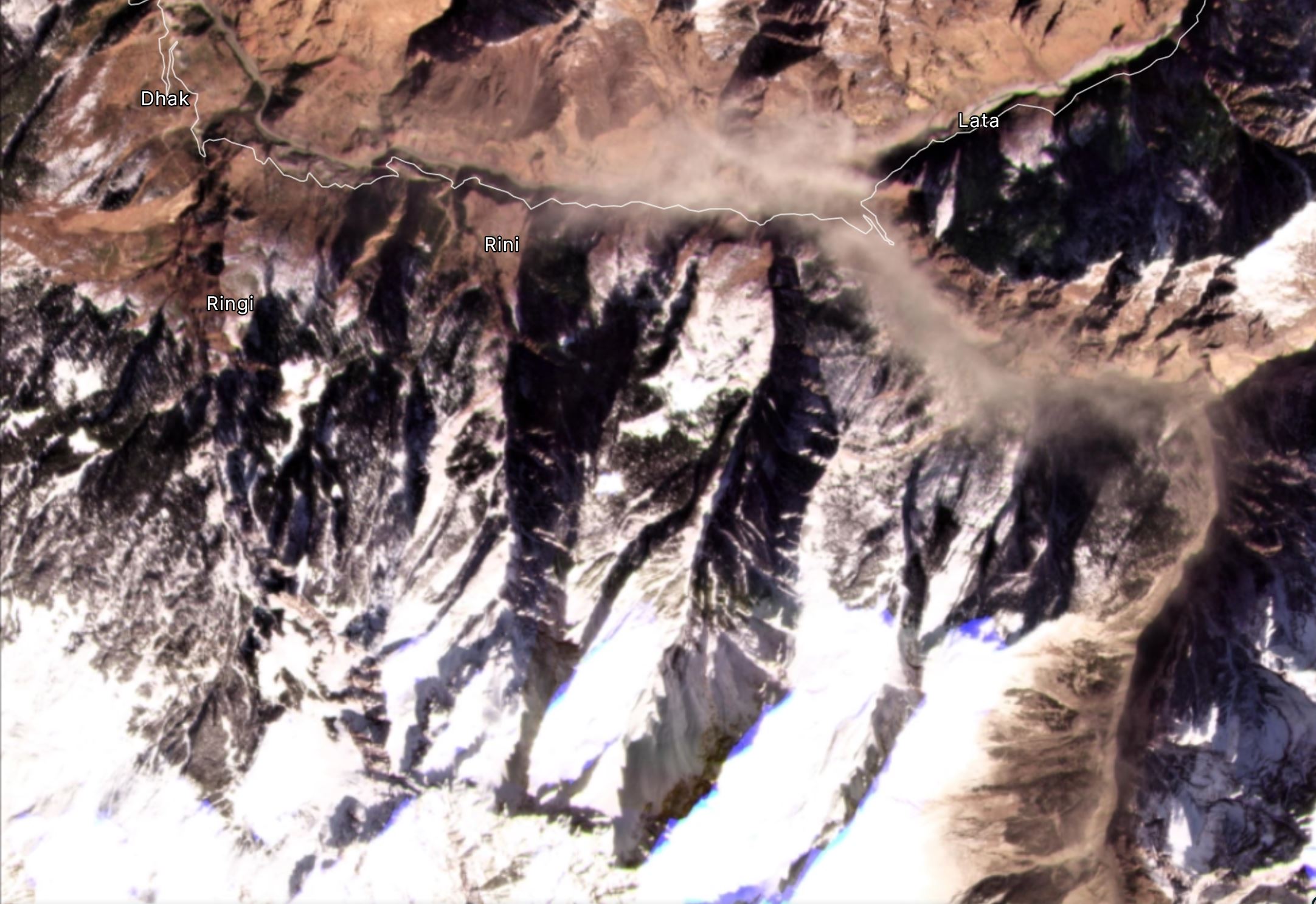
The area of the landslide downstream from Trisul that caused the Chamoli debris flow and flood. Image copyright Planet Labs, used with permission.
.
Note that dust still in the air when the image was collected.
The movement of the landslide was so rapid that the debris flow pushed water from the river ahead of it before incorporating it. You can see this very clearly in one of the videos:
https://twitter.com/LicypriyaK/status/1358318430940585987
.
Unfortunately there were many people working on the river floor, and in tunnels, as part of the two hydroelectric power schemes in the Chamoli area. This appears to account for the majority of the human losses. Rescue operations continue.
.
Misinformation and conspiracies
Whilst the cause of this event is clearly established, the media is continuing to publish stories that this was a glacial collapse, or an avalanche, or a GLOF. There was real uncertainty at the start, but we have known what happened for 24 hours now. This is quite unfortunate. I hope that this post will set the record straight.
This is important as a set of conspiracies are starting to emerge as to the cause of this landslide. For example, there are suggestions that such an event cannot occur in winter, meaning that it was dynamite that triggered the disaster. Some sources are linking this to activities by China.
This is not the case. This was a classic progressive failure in mountain flank. We have seen similar events elsewhere. It is fair to say though that these events might be increasing in frequency as a result of climate change.
.
Acknowledgement
Planet Team (2021). Planet Application Program Interface: In Space for Life on Earth. San Francisco, CA. https://www.planet.com/
 Dave Petley is the Vice-Chancellor of the University of Hull in the United Kingdom. His blog provides commentary and analysis of landslide events occurring worldwide, including the landslides themselves, latest research, and conferences and meetings.
Looks like a secondary landslide(s) is forming over the river from the camp (left lateral scar visible in video clip) due to undercutting of the slope but debris-laden flood that will add sediment to the flow and may block the river channel.
The ice along the river valley floor onto which the landslide debris ran out was most probably residual ice and compacted snow and associated debris from previous avalanche activity from around the same source area, e.g. 2016. It is not stagnant glacier ice as satellite imagery from prior to 2016 does not show any glacier ice there just river channel sediments. This sequence starts about 1.5 km downstream from the snout of the glacier.
The availability of good quality images so quickly and with such a fine time interval greatly helps piece together what has happened here.
Hi Dave,
Congratulations to your fast and well-founded analysis clarifying plenty of nonsense news in the media.
The crucial words you used to explain such unexpected disaster are: huge rock mass falling ONTO glacier ice and HEAT development from the kinetic fall energy.
As you have pointed out correctly, these events will increase with global warming. The only countermeasure can be a thorough hazard/risk mapping detecting the areas prone to heavy rock sliding with glacier ice at the valley bottom including hidden (“dead”) ice masses.
Best regards
Joerg
John is correct – it’s not glacier ice on the valley floor, rather the deposit from the 2016 avalanche, which may contain/have contained buried ice at some point. Post-event analysis, e.g. field photographs along the flood path, would help to establish ice content.
The dust from the slide seems present in images of 02/february. If so the slide occurred several days before the catastrophic flow which, then, may be related to a daming of a valley with time enough to accumulate a substantial amount of water before this dammed lake filled and broke the temporary dam, causing the catastrophic flow.
Thank you, I’m writing from India and very grateful.
Thanks for wonderful animation and explanation. Height of of Trishul peak is more than 7000 m. Is there explanation for quick melting of ice at such altitude in middle of winter?
On a side note, Planet Labs built this incredible capability by having a large network of small CubeSats in low earth orbit. That allows the company to get more time over a target across a range of lighting conditions. These tiny satellites are also cheaper to launch, operate and replace.
Could this translate into an early warning capability for landslides in mountainous areas?
Following from John, it looks like the deposit of ice and debris in the valley floor formed between Sept. 19th and 24th, 2016 and was never connected to the glacier. So it seems that the glacier itself was not involved at all.
Had there been any build up of water in the Dhauli gorge before or around the trigger of the event in trishul as @anil kulkarni points out there is no explanation for rapid melting to convert into large volume.
It is ultimately the crack development leading to landslide further leading to the debris flow.
The event somehow recalls the 2000 Yihong in Tibet, of course eith many differences. There volume of failure seems to be larger and rock\debris avalanche had blocked large river. Here, however, on the way it could form seversl minor trmporary dsms, which breach could add water to debris flow.
https://www.doonited.in/
all latest news of flood in Chamoli in Uttarakhand
Somehow the dynamics of the event (hanging glacier failing and melting) reminds me of the Huascaran events 1962 and 1970.