
8 January 2023
Joshimath: a complex landslide environment
Posted by Dave Petley
Joshimath: a complex landslide environment
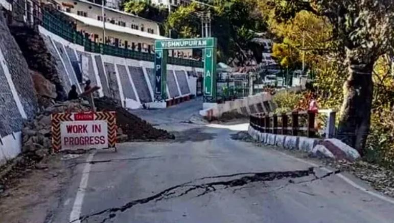
In India, the issues with the landslides at the hilltop town of Joshimath continue. There are a variety of narratives about the situation, ranging from those seeking to downplay the severity of the landslides to those expressing concerns that the situation could escalate quickly. There is also massive speculation about the likely causes of the ongoing movement.
Some aspects seem to be under little dispute. First, there is clearly substantial movement occurring in some parts of the complex. Second, that a survey last week identified 561 properties with severe cracks, with some information about the distribution of these by ward. For example, the Deccan Herald reports that:
So far, 561 houses in different areas of the town have developed cracks, including 153 in Ravigram, 127 in Gandhinagar, 71 in Manoharbagh, 52 in Singhdhar, 50 in Parsari, 29 in Upper Bazar, 27 in Suneel, 28 in Marwadi and 24 in Lower Bazar, District, District Disaster Management Officer NK Joshi said.
Two hotels are so seriously damaged that they have had to be evacuated – these are the Hotel Mount View and the Malari Inn, which I think are located about 1,300 metres apart. A key temple, Jyotir Math, has also developed severe cracks over the last 15 days. There are also reports of cracks along roads and in fields, and the adjacent town of Auli, a skiing resort, is also reported to be suffering from stability issues.
The situation is sufficiently serious that the Prime Minister’s Office is convening a meeting to discuss the problems today.
The geological and social setting for these landslides is very complex. It is clear that the site is an ancient landslide complex that is probably marginally stable. There is little doubt that aspects of the development at Joshimath has been suboptimal, with a lack of consideration at times of drainage and of appropriate excavation. The image below is quite instructive – these are examples of large retaining walls showing very obvious distress:-
Deformation in retaining walls at Joshimath. Image from the Hindustan Times.
.
But additionally there is speculation about the role of the tunnels for the Tapovan hydroelectric scheme – which was severely damaged two years ago in the Chamoli disaster – which are below Joshimath. One area of speculation is that the tunnels have changed the hydrology of the mountain, causing the failures. Whilst some hydrological changes may well have occurred, in general I would expect that the tunnels would cause dewatering of the mountain, which is unlikely to induce instability, although this is speculation on my part. The other is that blasting for the tunnels has triggered instability. The distances seem quite large for this, but perhaps topographic amplification might have played a role? Other alternatives include dewatering causing compaction of the materials forming the mountain, or subsidence associated with poor control of the tunneling causing stress changes in the mountain. This needs detailed investigation.
The causes of most landslides are complex, and it is very likely that this will be the case here. It is probably unwise to blame a single element for what is happening. It is likely to be a combination of multiple factors, acting in concert. Lessons need to be learnt of course, but for now there needs to be focus on a range of timescales, all starting without delay:
- In the very short term, assistance is needed to those being impacted by the landslides. Many families and businesses are likely to be displaced – they need urgent support. This is immediate but will also be a long term need;
- In the short to medium term, attempts need to be made to try to reduce the rate of movement. This is likely to need to focus on drainage and on support for the slope. Meanwhile, there is an urgent need to map out the signs of deformation on the buildings and other structures, and on the ground. This mapping will allow an understanding of which parts of the landslide complex are moving.
- In the medium term a proper ground investigation is needed. This will allow…
- …A long term plan for the stabilisation of the site.
Of course in the interim no new construction should be allowed, and it would be prudent to avoid any blasting. There maybe a case for ceasing all tunneling works in the area.
There are no quick fixes at Josimath, but urgent action is needed.
Finally, is anyone able to process InSAR data for the site? I think this might tell us a great deal.
 Dave Petley is the Vice-Chancellor of the University of Hull in the United Kingdom. His blog provides commentary and analysis of landslide events occurring worldwide, including the landslides themselves, latest research, and conferences and meetings.
Regarding ‘tunnels would cause dewatering of the mountain, which is unlikely to induce instability’:
Is this some kind of rule-of-thumb in geology? Because there are some counterexamples, think of sand castles that crumble once they dry up.
[Thank you. I understand your point, but the mechanics are different because of the different scales. Sandcastles derive their strength from surface tension at the grain scale. But, in general, dewatering occurs at the mountain scale – essentially the tunnel, and the disturbance that tunneling causes, can open up new fluid pathways that allow water to drain. D.]
It is a clear case of deep seated gravtitative movemment. The higher parts of the slopes, with no vegetations, show clear evidences of this phenomena. Nothing to do, except moving out, sorry!!
I was able to process the INSAR data for the site. Giving interesting results. Will keep posted here about the final results!!
Dear Sai deepak
It will be really interesting to see the temporal vectors of movements in Joshimath.
Thanks
Pradeep
The tunneling may not be associated with the crises at Joshimath. However, Risk mapping pointing to cracks and deformation, damage to building,s and vulnerable zones be highlighted as base for the rehabilitation plan.
This mapping will facilitate which parts of the subidences are moving. The monitoring of cracks for chalking out long term stabilization and restriction of urbanization will go a long way for sustainability of the mountain town.
-Dr V.K.Sharma