
29 June 2016
A massive secondary landslide in Devdoraki Gorge, Georgia
Posted by Dave Petley
A massive secondary landslide in Devdoraki Gorge, Georgia
In 2014 I posted about a very large landslide that caused extensive damage in the Devdoraki Gorge (which is often described as the Dariali Gorge) in Georgia. That landslide left a very large volume of debris in the river bed. On 23rd June this debris mobilised into a new, secondary, landslide that caused extensive damage along the key highway that links with Georgia and Russia via the Kazbegi Customs checkpoint. Thanks to a warning system installed after the 2014 events, no-one was injured, but the damage appears to be significant. The road remains closed.
Agenda.ge has a couple of reports about the landslide and its impact. They have posted this image, taken by the Georgia Road Department, of the damage that this landslide has caused:
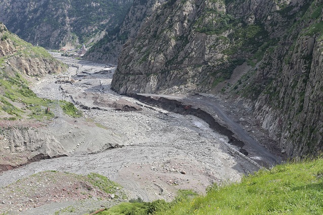
Landslide damage in Devdoraki Gorge, via the Georgia Roads Department and Agenda.ge
.
It is expected that clearing the blockage and repairing the road will take a fortnight. Exclusivenews.ge has an image that gives an impression of the magnitude of the task ahead:
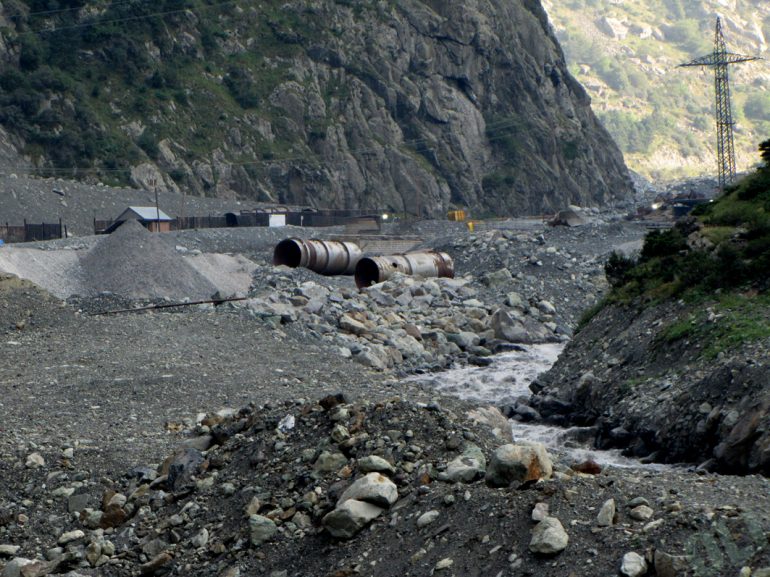
Landslide damage in Devdoraki Gorge, via Exclusivenews.ge
.
The origin of these landslides is the huge pile of sediment that has been left by the retreating Devdoraki glacier. Google Earth imagery, that predates the most recent landslides, shows the magnitude of the problem:
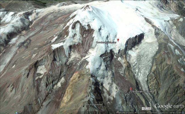
Google Earth imagery of the Devdoraki Glacier, showing the potential for significant landslides
.
It appears that further significant landslides are likely from this source, and thus that this river valley is likely to continue to be problematic. This valley is also the location if the Dariali Hydroelectric Power Plant (Dariali HPP) at an estimated cost of US$120 million. At the time that the Dariali HPP was being proposed there was considerable opposition on the basis of the potential for natural hazards, including sediment movement and mudflows. The impact of these multiple landslides on tghis scheme is not clear, but it appears from the top image that there is some HEP infrastructure in the river in the middle of the landslide deposit. A note (NB – this is a pdf) from an NGO, the Green Alternative, to the European Bank of Reconstruction and Development, highlights the problems:-
“There are at least three well known mudflow rivers Devdoraki, Khuro, Chkhere on the project site, that has been chosen in a way that the Dariali Hydro derivation channel portal is located exactly at the convergence of the Devdoraki and Tergi rivers and the Dariali dam, tank and headwork – just at the convergence of the Khuro and Chkhere rivers.”
The original landslide deposit is at the convergence of the Devdoraki and Tergi rivers.
The Dariali HPP is not the cause of these landslides, but is in close proximity. This most recent event is reported to have caused no damage however.
 Dave Petley is the Vice-Chancellor of the University of Hull in the United Kingdom. His blog provides commentary and analysis of landslide events occurring worldwide, including the landslides themselves, latest research, and conferences and meetings.
What looked to me like a “scrub line” on the right appears to be actually a geologic contact in subsequent photos on the Georgian website.
I saw a similar situation after very heavy rains in 1996-1997 on the North Coast of California: high flows overran a fill revetment and ate the roadbed beyond. The revetment stayed in place.
This was a small local, canyon-bound cluster of homes. In their case, it was months of walking in the rain until the road was repaired – it passed through several ownerships and was effectively an orphan road from a maintenance perspective.
Looking at photos in earlier posts on the Agenda.ge website, it probably IS a scrub-line, but from the front end of the initial slide mass.
They’re going to be busy there for many years.