
18 July 2018
Hidroituango: an update
Hidroituango: an update
I have not posted about Hidroituango (in Colombia) in the last few weeks, although the crisis has certainly not ended there. Seasonal changes in weather have meant that the inflows from the upper reaches of the catchment have reduced, allowing a slow reduction in water level. This has provided a welcome opportunity for the continued improvement of the dam, which is of course good news.
However, LAFM reports that last week a seismic event was recorded from within the power house cavern, which is interpreted as being a rockfall event. This has reduced the flow of water by 5 to 10%, with fears that this might become worse. One wonders about the state of the power house cavern, and indeed the remainder of the underground excavations, in light of these events.
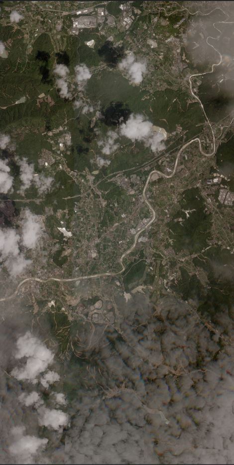
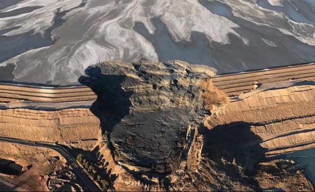
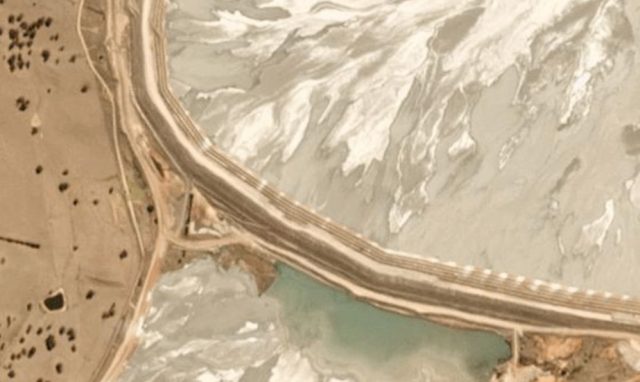
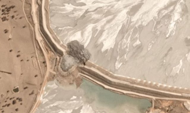
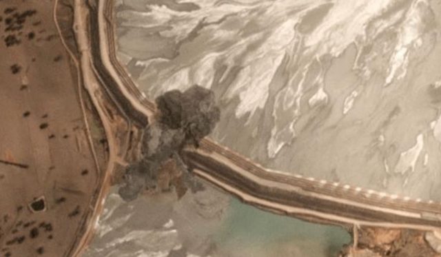
Meanwhile, further imagery of the site has become available. Last week, Planet Labs collected a high resolution image of the site using their 0.8 metre SkySat instrument:
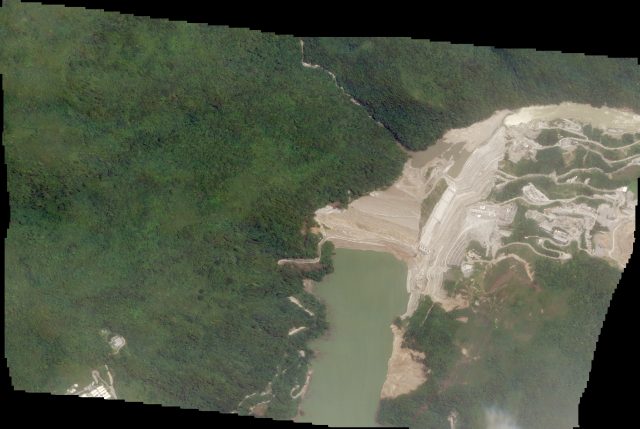
Planet Labs SkySat image of the Hidroituango site, collected on 9th July 2018 and used with permission.
.
This highlights in particular the continued evolution of the slope failures just upstream of the dam, on the right bank:-
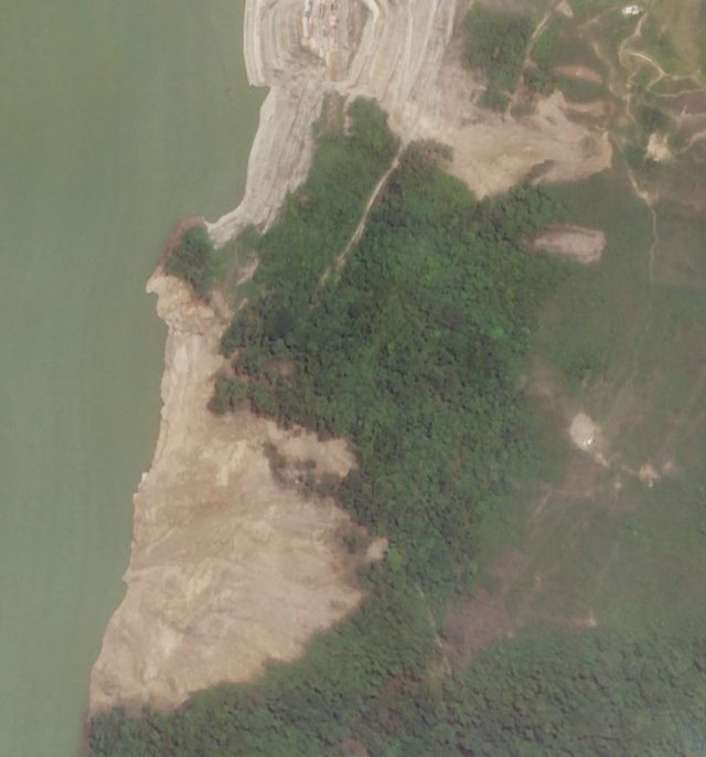
Planet Labs SkySat image of the slope failures upstream of the Hidroituango dam. Image courtesy of Planet Labs, used with permission.
.
Meanwhile, some instability is evident on the slopes above the reservoir as the slow drawdown continues. This is to be expected. On 11th July Andres Posada tweeted this image of landslides on the slopes at Hidroituango:-
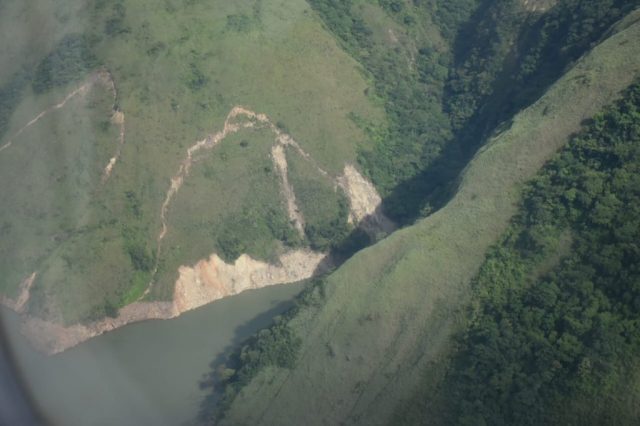
Drawdown landslides at Hidroituango. Image tweeted by Andres Posada on 11th July 2018.
.
These slope failures can be seen on the Planet Labs imagery as well – this is a 3 m Planetscope image collecgted on 16th July 2018:-
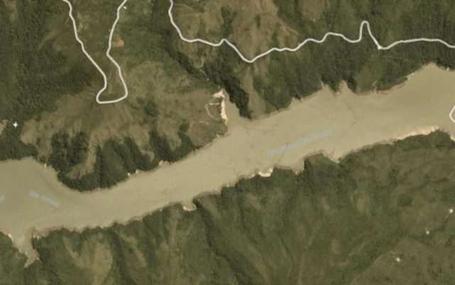
Planet Labs PlanetScope image of drawdown landslides at Hidroituango. Image courtesy of Planet Labs, used with permission.
.
Reference
Planet Team (2018). Planet Application Program Interface: In Space for Life on Earth. San Francisco, CA. https://api.planet.com
17 July 2018
Nanyu Township: a very large landslide in Gansu Province on Thursday 12th July 2018
Nanyu Township: a very large landslide in Gansu Province on Thursday 12th July 2018
Xinhua has posted some images of a very large, partially valley blocking landslide that occurred at Nanyu Township in Zhouqu County, located in Gansu Province, China. The landslide, which was triggered by rainfall, is reported to have a volume of about 5 million cubic metres. The best image of the landslide itself is this one, from Xinhua, which shows the lower portion of the displaced mass. It is clear that it has greatly constricted the river channel:-
The large landslide at Nanyu Township in Zhouqu County, northwest China’s Gansu Province. Image via Xinhua.
.
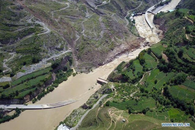
The partial blockage of the river has caused extensive flooding:-
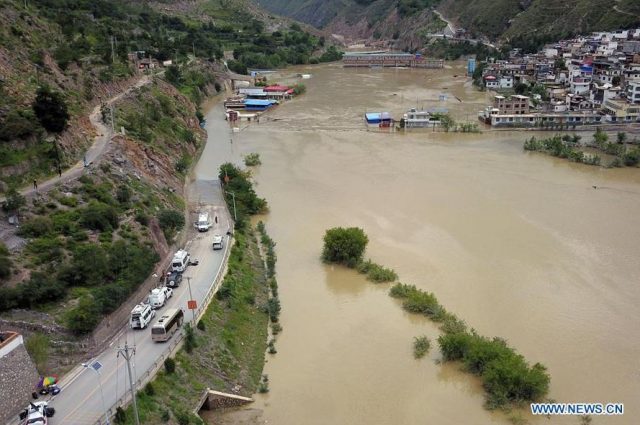
Flooding upstream of the landslide at Nanyu township in Gansu Province. Image via Xinhua.
.
On Google Earth the area affected by the landslide appears to be as below. The location is 33.719, 104.421:-
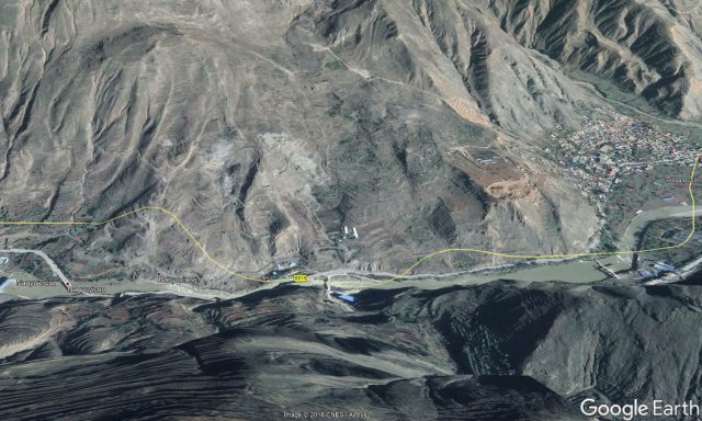
Google Earth image of the landslide at Nanyu township in Gansu Province
.
My interpretation of this is that the failure is on a large, pre-existing landslide. From the Google Earth imagery considerable slope modification has occurred. The section of the slope that has failed in this event is shown in the image below:-
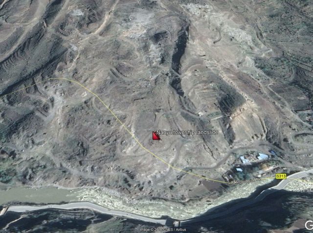
Google Earth image of the portion of slope that failed in the Nanyu township landslide
.
This section of slope shows considerable signs of distress and instability, and it is interesting to note that the river has a series of rapids in this area.
Gansu Province has a long landslide history. The following posts highlight landslides in this part of China:-
- Heifangtai terrace: spectacular loess flowslides in Gansu Province, China
- Spectacular landslides from the Gansu earthquake this week
- First image from the Gansu landslide
- Update: the Gansu landslide
- First video of the Gansu landslides
- Update: Dramatic increase in the loss of life in the Gansu landslide
- Two interesting landslide videos from Congjiang, China and Manali, India
- Two dramatic new landslide videos from China
- Zhouqu landslide – NASA satellite image
16 July 2018
High resolution satellite imagery of the Japan landslide disaster
High resolution satellite imagery of the Japan landslide disaster
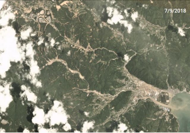
Planet Labs have now been able to collect some high resolution satellite imagery of the aftermath of the landslide and flood disaster that struck across Japan over the last few days. This is a SkySat image, which has a resolution of 0.8 metres per pixel. The image shows the area around Kure in the Hiroshima area, which was badly affected by the rains. This is the full image:-
Planet Labs SkySat image of Kure, Japan showing the aftermath of the Japan landslide disaster. Image courtesy of Planet Labs, used with permission.
.
Whilst there was a little bit of light cloud when the image was collected, the extremely large number of landslides is clear. This is a part of the southern portion of the image:-
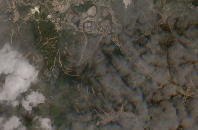
A portion of the Planet Labs SkySat image of Kure, Japan showing the aftermath of the Japan landslide disaster. Image courtesy of Planet Labs, used with permission.
.
It is clear that there are dozens of landslides, mostly consisting of shallow slips that have transitioned into channelised debris flows, in the imagery. The nature of these landslides is perhaps best illustrated by this set, in the northeast of the image:-
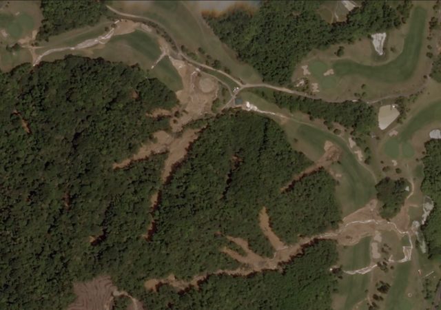
Detail of a portion of the Planet Labs SkySat image of Kure, Japan showing the aftermath of the Japan landslide disaster. Image courtesy of Planet Labs, used with permission.
.
Here it is clear that the landslides started as small slips in the hilly, forested portion of the slopes. The debris has entered the channels and then entrained channel material. In many cases the same channel has seen slips from multiple slope portions. The debris has run out onto the golf course, where deposition of the mobile mass has occurred.
Of course it also serves to illustrate the extraordinary quality of satellite imagery that is now available. Many thanks to Robert Simmon at Planet Labs for his help with obtaining the imagery.
Reference
Planet Team (2018). Planet Application Program Interface: In Space for Life on Earth. San Francisco, CA. https://api.planet.com
15 July 2018
Panjshir province, Afghanistan: using Planet Labs imagery to interpret the deadly debris flow
Panjshir province, Afghanistan: using Planet Labs imagery to interpret the deadly debris flow
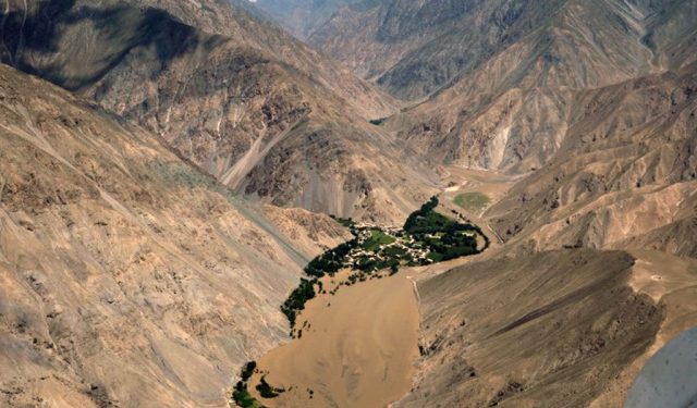
On Thursday morning a deadly debris flow struck a small village, in some reports named as Pashgor (or Peshghor), in Panjshir province, Afghanistan, killing at least ten people. There has been considerable speculation about the cause of this disaster, including landslides, melting icecaps and the breaching of lakes. For example, Accuweather has an article claiming that melting snow caused a dike to melt, although the source of this information is not clear. The Dhaka Tribune / AFP has the best image that I have seen of the aftermath of this event:-
The aftermath of the debris flow in Panjshir province, Afghanistan, on 12th July 2018
Fortunately, at this time of year this area of Afghanistan has little cloud, rendering satellite imagery a powerful tool to understand the event. I have looked at Planet Labs imagery, which reveals the cause. So, first, here is the before and after imagery of the downstream impacts of the debris flow. The image below, collected on 11th July, shows the community struck by the debris flow before the event occurred:-
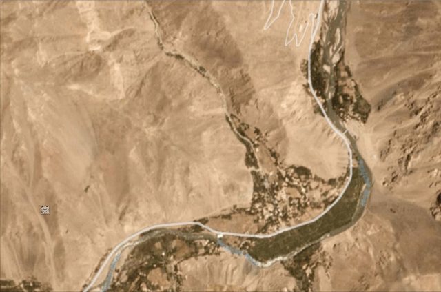
The community of Pashgor struck by the debris flow on 12th July 2018 in Panjshir Province, Afghanistan. Image, dated 11th July 2018, via Planet Labs, used with permission.
.
This image shows the aftermath – the track of the debris flow, and the vast amount of new sediment in the main channel, are clear:-
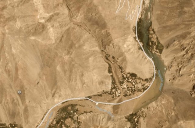
Planet Labs imagery, dated 12th July 2018, of the aftermath of the debris flow in Panjshir province, Afghanistan. Image via Planet Labs, used with permission.
.
It is not clear to me as to whether the channel is completely blocked. There is some chance that this might be the case. But the imagery allows the course of the debris flow to be tracked upstream to find the source. This lies about 10 km to the north as the crow flies, probably 15 km via the channel. The source is at 35.47 N, 69.64 E if you are interested in looking at Google Earth. At this location, at an elevation of about 4500 metres, we find this lake on the imagery before the disaster:-

The ephemeral lake in the mountains of Panjshir province, which caused the debris flow disaster on 12th July 2018. Image via Planet Labs, used with permission
.
The image of the following day shows that the lake had completely drained, generating the debris flow that destroyed the village:-
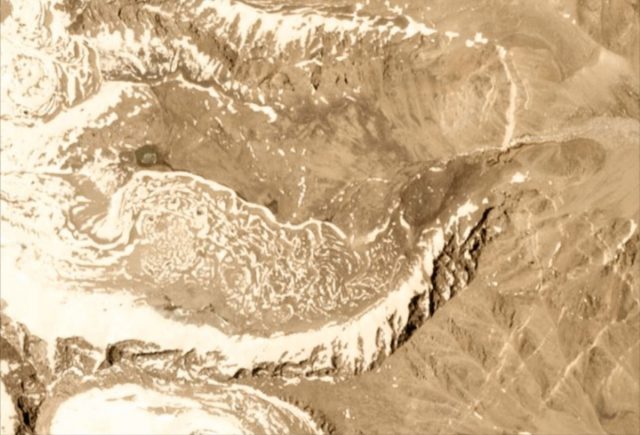
Planet Labs image dated 12th July 2018 showing the drained ephemeral lake that caused the debris flow of 12th July 2018 in Panjshir province. Image, dated 12th July 2018, courtesy of Planet Labs, used with permission.
.
The lake was about 400 metres long and 150 metres wide. Interesting it was not present at any point last summer as far as I can tell, so it is likely to have been formed by temporary blocking of the valley by ice and/or debris (can anyone provide any insight into this process? I am assuming that this was probably an ice dam?).
Afghanistan is of course no stranger to landslide disasters. It is somewhat frustrating to see some news agencies illustrating articles about this event with imagery from the dreadful Abe Barek landslide in May 2015.
Reference
Planet Team (2017). Planet Application Program Interface: In Space for Life on Earth. San Francisco, CA. https://api.planet.com
13 July 2018
Rohingya refugee camps: your help needed
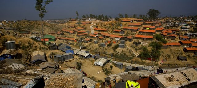
Displaced Rohingya people living on cut slopes in the refugee camps of Cox’s Bazaar in Bangladesh. Image by Manish Swarup/AP , via Global Citizen
Rohingya refugee camps: your help needed
I have written before about the severe level of risk faced by the displaced Rohingya people from Myanmar, now living in refugee camps in the Cox’s Bazaar area of Bangladesh. About a million people are living in temporary camps across a hilly area that was previously mostly unpopulated. The soils are weak, consisting of sands and soils, and of course this is an area with a monsoonal climate. The monsoon is now building in intensity, and will last for the next three months or so. Some fatalities associated with landslides have already occurred.
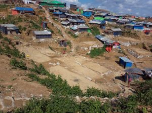
Rohingya houses on cut slopes in Cox’s Bazaar in Bangladesh. Image via a tweet by Manuel Marques Pereira
The hazards posed by landslides are severe. In occupying this hilly land the people have had to cut the slopes to build benches to allow the construction of bamboo framed buildings. Inevitably the cooking needs of so many displaced people has meant that the protective trees have been removed to be burnt. As supplies of wood have dwindled the Rohingya people have been forced to dig up the roots to burn as well. The consequences for slope stability are dire – the combination of weak materials (especially where the slopes are predominantly sandy), cut slopes, removal of vegetation and disruption of the soil is a toxic mix that means that landslides are inevitable. There have already been some severe slope accidents.
The magnitude of the problem does not allow slope engineering as a widespread solution, although it may help in some particularly severe locations. Across the area there is a very small number of rain gauges; the coverage is too low to provide a decent understanding of real time rainfall. In a hilly area like this orographic effects mean that there will be considerable variation in rainfall patterns over a short distance. In addition, the most serious rainfall events in the monsoon are likely to be convective – the so-called cloudburst events – meaning that a dense network is needed to be effective.
Your help is needed
I have been talking to one of a very small number of landslide experts in country trying to deal with the crisis, Marina Drazba. This is a situation in which an early warning system of some sort might be helpful, but it is far from clear as to what an effective system, which can be implemented quickly, might consist of. Given that we are talking about hundreds of small slopes over a large area, technology like slope radar is not going to be applicable. So the questions that we are asking are:

Densely packed Rohingya houses on steep, weak slopes in Bangladesh. Image via VOA News
1. What effective systems are in place in similar circumstances elsewhere? Are there examples of good practice in other less developed countries?
2. What could an effective system look like in this situation?
3. How is it possible to communicate the hazard in real time if the alert is triggered?
4. How can you avoid, or manage, false alarms?
The aim here is to try to implement an early warning system quickly, if that is possible. If you have answers to these questions, please could you post a comment. Please help – we are open to any ideas or thoughts or ideas, or any experiences that you might have.
12 July 2018
Images of the disastrous landslides in Japan this week
Images of the disastrous landslides in Japan this week
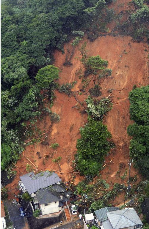
Over the last few days Japan has suffered from record levels of rainfall, triggering large numbers of landslides. In total at least 200 people have been killed in flood and landslide events.
To give an idea of the scale of this event, Planet Labs have published a before an after image pair of just one part of the affected area. This is the “after” image, showing the landslides around Yasuuracho Chuo, near to Hiroshima:-
Planet Labs imagery of the aftermath of the landslides at Yasuuracho Chuo, near to Hiroshima, in Japan.
.
The image above shows multiple shallow slides, many of which appear to have transitioned into high mobility channelised debris flows. These are highly dangerous. Japanese news agencies have been publishing images that illustrate the scale of these landslides. The image below, published in The Mainichi, shows shallow slides at Uwajima in Ehime Prefecture. It may be no coincidence that the landslides have occurred in areas that have had heavy modification of their vegetation:
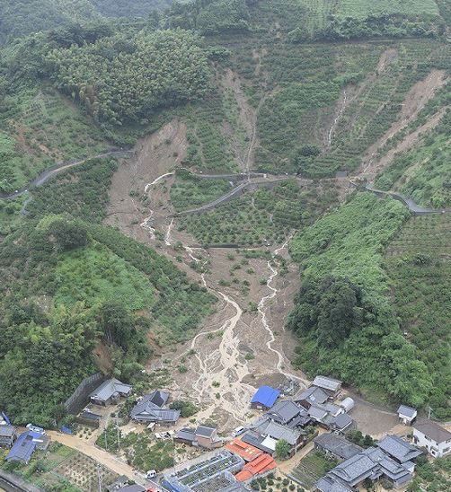
Landslides at Uwajima in Ehime Prefecture, Japan. Image via The Mainichi
.
Another image, also from The Mainichi, shows the impact of channelised flows in structures:-
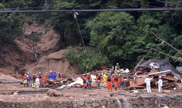
The aftermath of a channelised debris flow at Kure in Hiroshima Prefecture, Japan. Image via The Mainichi.
.
Meanwhile, the image below, published by Kyodo (via The Mainichi) shows a shallow slide in a very steep, deeply weather slope in Kitakyushu, southwestern Japan:-
.
A shallow slide on a deeply weathered slope at Kitakyushu, southwestern Japan. Image from Kyodo.
.
The Japan Times has this spectacular image of the failure of a slope above a highway. Note that this is an engineered slope; the displaced slope reinforcement can be seen in the landslide debris. As such this is a failure of design:-
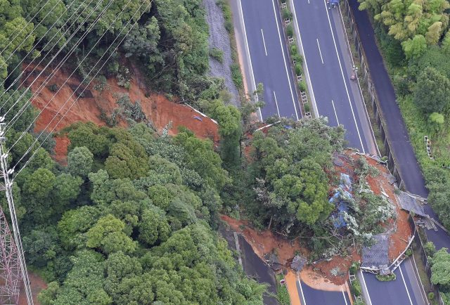
The failure of an engineered slope on the Kyushu Expressway in Kitakyushu, Fukuoka Prefecture in Japan. Image via the Japan Times.
.
And the image below shows the impact of two flow type landslides on a highway in Otoyo in Kochi Prefecture:-
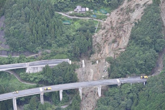
The impact of a landslide on a highway at Otoyo in Kochi Prefecture, Japan. Image via The Mainichi
.
At least 47 sections of expressway have been damaged by the landslides.
This is without doubt the most significant landslide event of 2018 to date. I’m sure more information will emerge in due course. The landslide research community in Japan is very large, and they are assiduous in documenting large landslide events. Japan is of course no stranger to massive landslide events , caused by both exceptional rainfall and earthquakes.
Reference
Planet Team (2017). Planet Application Program Interface: In Space for Life on Earth. San Francisco, CA. https://api.planet.com
10 July 2018
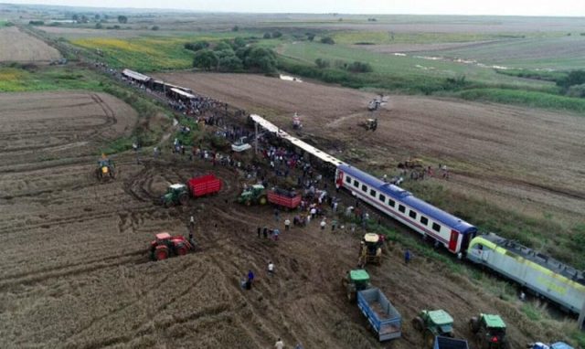
Tekirdag Province, Turkey: a geotechnical failure caused a derailment, killing 24 people
Tekirdag Province, Turkey: a geotechnical failure caused a derailment, killing 24 people
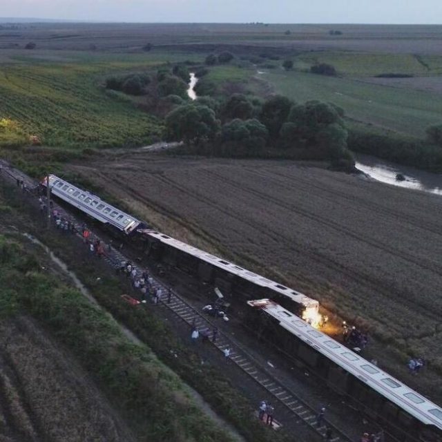
On Sunday 8th July 2018, a train travelling towards Istanbul from Erdine in Turkey suffered a very major derailment in a rural part of Tekirdag Province. A number of carriages left the rails and overturned. In total 24 people were killed, and a further 73 people were injured. There are some quite distressing pictures circulating showing the aftermath of the accident (which I will not reproduce), but this one shows the overall situation after the accident (from Afternoon Voice):
The aftermath of the train derailment in Tekirdag Province, Turkey on Sunday. Image via Afternoon Voice.
.
This train derailment has been widely reported to be the result of a small landslide triggered by heavy rainfall, which is slightly intriguing given the topography shown above. Other reports have suggested a culvert failure, which seems more likely. This image, published in Hurriyet Daily, appears to provide the answer:-
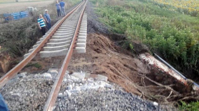
The possible cause of the rail accident in Tekirdag Provice in Turkey on 8th July 2018. Image via Hurriyet Daily
.
The accident seems to have resulted from the collapse of a retaining wall above a culvert on the rail embankment, which has allowed the ground and ballast to slip from under the rails. Presumably this is the culvert for the stream that is shown in the first image, just behind the last derailed carriage. The image above shows the distortion to the rails and the collapse of the sleepers (note the fragments) that presumably occurred as the train crossed the slipped section of the embankment. The image below shows that situation in more detail, although the actual ground failure is just off the side of the image:-
The aftermath of the train derailment in Tekirdag Province on Sunday 8th July 2018. Image via Hurriyet Daily.
.
The remarkable thing about this tragedy is that it was caused by such a small geotechnical failure. In total the amount of ground that has shifted is probably a few cubic metres. Landslide-induced rail accidents are not unusual; this accident illustrates the need for vigilance in the management of earthworks on the rail network.
You may be interested in these previous posts about landslides on railway systems around the world:-
- Tumpat-Kuala Lipis: A landslide induced train derailment in Malaysia
- Unbelievable – a video of a landslide striking and derailing a freight train in Everett, near Seattle, USA
- The train derailment on the West Highland line on Thursday
- NTSB report: train collision with a landslide in Northfield, Vermont
- Railway landslides in the UK yesterday
- Images of the Italian railway landslide today
- Landslide-induced train accident in China
- The Harbury tunnel and cutting landslide in Central England
- New images of the Hatfield Colliery (coal mine) landslide in northern England
9 July 2018
Fagraskógarfjall: a very large landslide in Iceland on Saturday
Fagraskógarfjall: a very large landslide in Iceland on Saturday
Early on Saturday morning a large landslide detached from the Fagraskógarfjall massif in western Iceland, near to Hitardal. RUV has a report about this landslide, which it is claimed may be the largest event recorded in Iceland to date (though I doubt that it is larger than the Askja landslide in 2014 in reality). RUV has the following image of the landslide, which gives a good impression of the scale:-
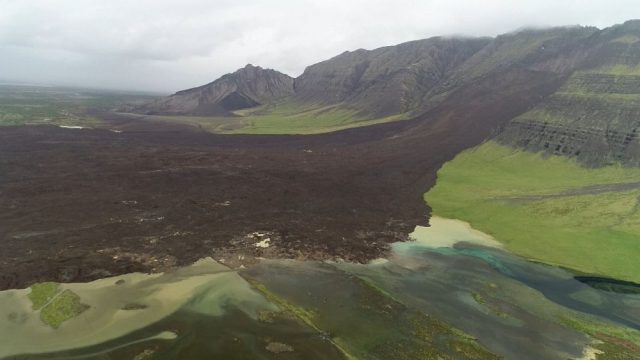
The landslide at Fagraskógarfjall in Iceland. Image via Vilhjálmur Þór Guðmundsson – RÚV.
.
Meanwhile, Iceland Review has a good image of the landslide from another perspective too:
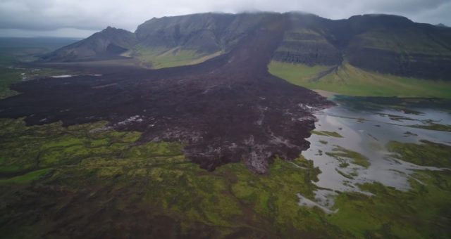
The large landslide at Fagraskógarfjall in Iceland. Image via Iceland Review.
.
There is a good drone video on Visir. The landslide debris reportedly covers an area of about 1.8 km² and a runout distance across the plain of about 1.5 km. There is a news report, also with some good quality drone and helicopter imagery of the landslide, on RUV. It is in Icelandic, but Google Translate does a reasonable job. This is clearly an area that is blessed with a large number of insects. The landslide has blocked the river, and a lake is developing, though it appears that the water will probably find an alternative channel fairly quickly.
Whilst northern Europe is having an exceptional summer (the weather in the UK is the driest in 40 years for example), Iceland is suffering from very poor conditions. May was the wettest on record in Reykjavik, and June was no better, suffering the lowest number of hours of sunshine in June in recorded history. Thus, it seems likely that the landslide was a consequence of the high levels of recent rainfall.
This landslide will have generated a strong seismic signal, but reports suggest that there is no seismic station within 40 km, sadly.
5 July 2018
Cadia gold mine: Planet Labs imagery of the sequence of events of the tailings dam failure in March 2018
Cadia gold mine: Planet Labs imagery of the sequence of events of the tailings dam failure in March 2018
Back in March I blogged about the tailings dam failure at Cadia Gold Mine on Friday 9th March 2018. This failure involved the collapse of a structure between two tailings ponds; fortunately on this occasion there was no release of tailings to the environment. This is the best image of the failure site that I have seen, posted on the website of Mining Journal:
The tailings dam failure at Cadia Gold Mine, courtesy of Mining Journal.
Prompted by a recent exchange about this event, I have been back to take a look at the Planet Labs archive of imagery of this event. It’s quite interesting. This is an image collected on 9th March (the day of the failure) at 01:14 UTC. In this image the structure is intact:
Planet Labs image of the site of the Cadia gold mine failure in March 2018. Image collected at 01:14 UTC on 9th March 2018. Image used with permission.
.
This image was collected on the same day, but about 22 hours later at 23:32 UTC on 9th March. The failure has now developed:
Planet Labs image of the tailings dam failure at Cadia gold mine. Images collected at 23:32 UTC on 9th March 2018. Image used with permission
.
An image collected on 11th March 2018 at 01:13 UTC shows no change, but one collected on the same day at 23:31 UTC shows that a secondary failure has developed:-
Planet Labs image of the secondary failure of the tailings structure at Cadia gold mine. Image collected at 23:31 on 11th March 2018. Used with permission.
.
The most recent images show little change bar the construction of a new haul road:-

Recent Planet Labs image of the site of the tailings dam failure at Cadia gold mine. Image dated 00:57 UTC on 26th June 2018. Used with permission.
.
So, interestingly, this was a two phase failure event. Newcrest, the mining company responsible, are now storing their tailings at another site in the old Cadia Hill open pit mine.
Reference
Planet Team (2017). Planet Application Program Interface: In Space for Life on Earth. San Francisco, CA. https://api.planet.com
3 July 2018
Shimian County: a freak rockfall accident in China
Shimian County: a freak rockfall accident in China
The Chengdu Business Daily has a report (in Chinese) of a freak rockfall accident that occurred in Shimian County in Sichuan Province, China on 30th June. At the time a coach was driving on the S217 Provincial Road between Chengdu and Wuhu, carrying 38 people. The coach was struck by a large boulder. The image below, from the same source, shows the aftermath of the accident:-
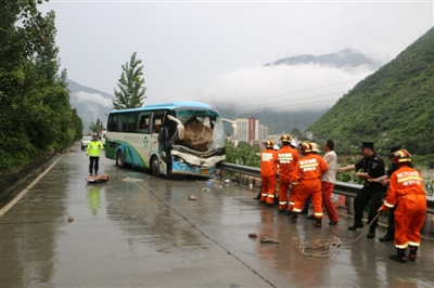
The aftermath of the rockfall accident in Shimian County, Sichuan Province, on 30th June 2018. Image from the Chengdu Business Daily.
.
It appears that the boulder penetrated, and became wedged through, the windscreen of the coach. The driver, Zhao Jianguo, a 44 year old native of Chengdu, was pinned in his seat and was killed. A further six people were injured. Despite his fatal injuries the driver managed to steer the coach to a safe stop, saving the lives of the remaining passengers. The coach left a ten metre long skid mark in the road prior to hitting the guard rail, which is being interpreted as an indication that the driver was applying the brakes prior to the impact with the crash barrier on the side of the road, despite his very serious injuries.
Rockfalls on highways in China are not unusual, and impacts between rocks and vehicles are common in mountain chains around the world. I have not seen an example in which a boulder that must weigh several tonnes penetrates a vehicle in this way however. It is a truly freak accident.
We are now well into the monsoon season across Asia, and reports of landslides are coming thick and fast, as expected. Spectacular debris flow videos are emerging from the heavy rains in Vietnam for example, including this remarkable example (which occurs in two phases):-
.
And this one on Liveleak, which I cannot embed (but is worth a look).
 Dave Petley is the Vice-Chancellor of the University of Hull in the United Kingdom. His blog provides commentary and analysis of landslide events occurring worldwide, including the landslides themselves, latest research, and conferences and meetings.
Recent Comments