13 July 2018
Rohingya refugee camps: your help needed
Posted by Dave Petley

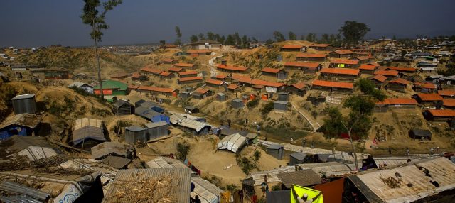
Displaced Rohingya people living on cut slopes in the refugee camps of Cox’s Bazaar in Bangladesh. Image by Manish Swarup/AP , via Global Citizen
Rohingya refugee camps: your help needed
I have written before about the severe level of risk faced by the displaced Rohingya people from Myanmar, now living in refugee camps in the Cox’s Bazaar area of Bangladesh. About a million people are living in temporary camps across a hilly area that was previously mostly unpopulated. The soils are weak, consisting of sands and soils, and of course this is an area with a monsoonal climate. The monsoon is now building in intensity, and will last for the next three months or so. Some fatalities associated with landslides have already occurred.

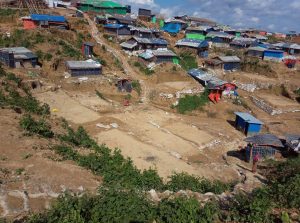
Rohingya houses on cut slopes in Cox’s Bazaar in Bangladesh. Image via a tweet by Manuel Marques Pereira
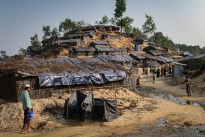
The hazards posed by landslides are severe. In occupying this hilly land the people have had to cut the slopes to build benches to allow the construction of bamboo framed buildings. Inevitably the cooking needs of so many displaced people has meant that the protective trees have been removed to be burnt. As supplies of wood have dwindled the Rohingya people have been forced to dig up the roots to burn as well. The consequences for slope stability are dire – the combination of weak materials (especially where the slopes are predominantly sandy), cut slopes, removal of vegetation and disruption of the soil is a toxic mix that means that landslides are inevitable. There have already been some severe slope accidents.
The magnitude of the problem does not allow slope engineering as a widespread solution, although it may help in some particularly severe locations. Across the area there is a very small number of rain gauges; the coverage is too low to provide a decent understanding of real time rainfall. In a hilly area like this orographic effects mean that there will be considerable variation in rainfall patterns over a short distance. In addition, the most serious rainfall events in the monsoon are likely to be convective – the so-called cloudburst events – meaning that a dense network is needed to be effective.
Your help is needed
I have been talking to one of a very small number of landslide experts in country trying to deal with the crisis, Marina Drazba. This is a situation in which an early warning system of some sort might be helpful, but it is far from clear as to what an effective system, which can be implemented quickly, might consist of. Given that we are talking about hundreds of small slopes over a large area, technology like slope radar is not going to be applicable. So the questions that we are asking are:

Densely packed Rohingya houses on steep, weak slopes in Bangladesh. Image via VOA News
1. What effective systems are in place in similar circumstances elsewhere? Are there examples of good practice in other less developed countries?
2. What could an effective system look like in this situation?
3. How is it possible to communicate the hazard in real time if the alert is triggered?
4. How can you avoid, or manage, false alarms?
The aim here is to try to implement an early warning system quickly, if that is possible. If you have answers to these questions, please could you post a comment. Please help – we are open to any ideas or thoughts or ideas, or any experiences that you might have.


 Dave Petley is the Vice-Chancellor of the University of Hull in the United Kingdom. His blog provides commentary and analysis of landslide events occurring worldwide, including the landslides themselves, latest research, and conferences and meetings.
Hi David,
You may recall that AGU’s Thriving Earth Exchange (www.thrivingearthexchange.org) works with communities to develop projects that advance their priorities in areas of natural hazards, natural resources and climate change so that pro bono Earth and/or space scientists can be matched to work with them to co-create a tool/solution.
I would be happy to connect with a representative of the community(ies) affected, Marina and you to develop a project that could support the development of a solution that would be community-driven and -owned.
Natasha Udu-gama
Thriving Earth Exchange
AGU
I’m not an expert in slope stability by any means, but in my experience as a geologist in the mining industry, I know that there are a number of manufacturers that have off-the-shelf monitoring systems for high walls in open pit mines. They tend to be easily deployable, designed to work on small to medium relief terrain and rugged. Further, I know of several mines with multiple open pits scattered over a several kilometer area that have the sensors deployed as a network to monitor the entire property and provide quick warning with a minimum of false alarms as disrupting production for false failures is hugely disruptive. Perhaps one of these systems can be adapted for use?
Dave,
I’m a professor at Michigan Tech University in Houghton, MI USA. I spent ten years with the Shell Oil Company in their mining division, mostly in the Appalachian Region of the US. I was the engineering manager for their subsidiary company and worked extensively on landslides. After leaving Shell I did my doctoral research on slope stabilization system for the US Air Force. After obtaining my Ph.D. I received a project from the US Bureau of Mines on the stabilization of (again) Appalachian slopes. The project title is
APPLICATION AND ANALYSIS OF ANCHORED GEOSYNTHETIC SYSTEMS
FOR STABILIZATION OF ABANDONED MINE LAND SLOPES
This is a system that can use natural materials or whatever is available. One of the outcomes of this research was that once the system starts to become stresses, it becomes obvious a slope failure is imminent. But what was really interesting about this system is that it had a significant stabilizing effect on the slope preventing slope failure.
I thought at the time that this could be used in underdeveloped countries since they can be installed by hand and they can use whatever is available.
If you are interested let me know and I can send you or whoever might be interested in a paper or report on this work
Regards,
Stan Vitton
I know that such plants as Vetiver (Chrysopogon zizanioides) is a common grass, very effective in soil stabilisation, the roots can grow several meters in depth. It is very easy to grow and to multiplicate so it’s a very low-cost solution, often used in poor countries. There should be a massice campaign of Vetivervegetalisation on those slopes, it’s not a warning system, but it should improve soil stability pretty shortly, for a very low cost.
It may be interesting to your readers to see an interactive, detailed map that includes landslide hazard for the Cox’s Bazar area from IRIN – although useful, the hazard modeling is perhaps not as detailed and accurate as may be wished (http://www.irinnews.org/maps-and-graphics/2018/02/05/mapped-how-monsoon-rains-could-submerge-rohingya-refugee-camps). They have also published an interesting overview of the situation (http://www.irinnews.org/news-feature/2018/06/21/heavy-rains-huge-wake-call-relocate-vulnerable-rohingya).
Dr. Bayes Ahmed has a web page for landslide warnings in Cox’s Bazar, although it doesn’t seem to be working when I’ve looked. That project started with a landslide early warning for a city in Bangladesh that does seem to be functioning at some level (http://www.landslidebd.com/coxs-bazar-warning).
My colleagues and I have also been wondering how to help with the dire situation in Cox’s Bazar. While we have no real solutions, we’ve had some thoughts and found some potentially useful information:
1. What effective systems are in place in similar circumstances elsewhere? Are there examples of good practice in other less developed countries?
I recently heard about a system in Indonesia that uses a simple bucket with local people trained to alert the community when the bucket has filled to a certain level over a certain amount of time. I don’t have a link for that effort but Indonesia seems to be quite progressive on their detailed landslide hazard mapping and furthering their automated landslide early warning systems (http://www.nbro.gov.lk/index.php?option=com_content&view=article&id=118&Itemid=426&lang=en).
2. What could an effective system look like in this situation?
While not exactly a solution, but useful for lessons learned: Mercy Corps and Practical Action had a pilot landslide early warning system in western Nepal (2011-2016). They had the expected difficulties such that rain storms met their thresholds for intensity/duration but slides weren’t triggered. They concluded they needed to monitor individual slides and came up with an inexpensive wood peg system. See (https://www.echocommunity.org/en/resources/f29e6847-f5e7-4ac9-a286-fb77d5bc4f19) and (http://nepal.mercycorps.org/pdf/publication/estimating-landslide-probability.pdf). Without vegetation and with a lot of disturbances, the Cox’s Bazar situation may be more apt to slide once thresholds are reached, compared to areas with more variable geology, vegetation, and other factors. Also, the following paper with details on a community-based flood early warning system in Nepal was quite valuable for developing the design of alerts and warnings with the community (http://idrimjournal.com/index.php/idrim/article/download/60/37).
3. How is it possible to communicate the hazard in real time if the alert is triggered?
In some volcanic communities in central America I’ve heard they use a large gourd/bucket/pot as a bell or drum, and hit it to alert people downhill of coming volcanic hazards (numerous people are in charge of relaying the alarm over distances). Battery-operated sirens (explained in the flood paper above) can also be used and megaphones, but they all need to be loud enough during torrential rains. Potentially single beats are 2nd tier warnings, double beats are 1st tier alarms.
4. How can you avoid, or manage, false alarms?
If you ensure the warning system is run and maintained by local people (monitoring and recording rain gauges and alerting local leaders, for example), you can put the question to them to decide when to send the alert and when to send a second-tier alert, or nothing. It puts the people at risk in charge of deciding the levels of risk to tolerate. They can then adjust the alert system as incidents occur. Also, by giving warnings/alerts even when not absolutely certain that a debris flow or slide may occur, the individual families or a community can decide for themselves if they wish to respond. Very important to the system is ensuring that locals (with help from experts) determine where to safely evacuate (with routes) and which homes are most likely to be safe/unsafe during heavy or prolonged rain, so people can make informed decisions for themselves. This of course all needs much input from the whole community so that everyone understands what the alarms mean, that they do not guarantee a slide, that there is also some danger in evacuating during a storm in the dark, and what their options are for safer sheltering in place vs. evacuating. Learning to recognize basic construction practices that are likely to fail in wet weather would also be valuable. I’ve seen people digging on top of slopes to make flat surfaces for homes by pushing fill off the hillslope (zero compaction). I really worry people building on the fill will be extra vulnerable in wet weather, as will their downhill neighbors.
I look forward to hearing from your other readers.
I hestitate to contribute, being aware of my ignorance of both the actual living conditions of the poor people involved, the methods of early warning etc, but could the alarm be raised by the use of handbells distributed by a relief organisation? Very low tech and the people own and operate their own system.
Speaking to question #2: For the situation of a relatively large area with very little local data, an early warning model could be developed quickly by using primarily remote sensing data. For rainfall, GPM (Global Precipitation mission) is a product to consider. Its resolution might not solve the problem of local variation due to topography, but it produces a full-spatial coverage grid at high temporal resolution as well, and has near-real time turnaround, I believe. This can be used in a typical rainfall threshold system, but this typically requires a large database of previous events to calibrate.
An alternative is to use a physically-based model.
Depending on what data is available and its resolution, a DEM and some current land cover data could be used as inputs to one of several susceptibility models (e.g. TRIGRS) which use a mathematical model of infiltration to estimate the timing of failure.
The following articles demonstrate such a system (I am not affiliated with them)
doi.org/10.1007/s10346-010-0219-7
doi.org/10.1007/s12665-011-0997-9
doi.org/10.1007/s11069-010-9670-y
There isn’t any structural load house are weightless , inform them that landslide can happen with heavy rains, find the most suspicious ones try to apply some cheap stabilisation earth work around those places , you can do slope analysis too , find your mechanism use your soil and slope parameters and generate a factor of safety and compare it with maximum water table level at the top of hill for worst raining conditions and try to see where and how it fail, there you can use geosuite slope w or any other, there is not much to do , informing people is the best, if you have chance to find out the raining amount during raining you can trigger warning but the best warning will be the Peoples senses ,they will be aware with heavy rains and they should know what possibly can happen , good luck.