
15 July 2018
Panjshir province, Afghanistan: using Planet Labs imagery to interpret the deadly debris flow
Posted by Dave Petley
Panjshir province, Afghanistan: using Planet Labs imagery to interpret the deadly debris flow
On Thursday morning a deadly debris flow struck a small village, in some reports named as Pashgor (or Peshghor), in Panjshir province, Afghanistan, killing at least ten people. There has been considerable speculation about the cause of this disaster, including landslides, melting icecaps and the breaching of lakes. For example, Accuweather has an article claiming that melting snow caused a dike to melt, although the source of this information is not clear. The Dhaka Tribune / AFP has the best image that I have seen of the aftermath of this event:-
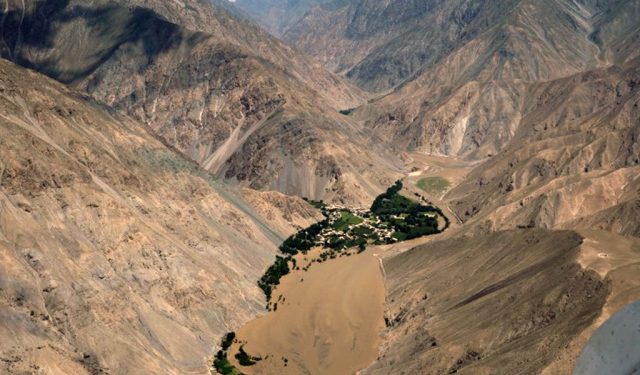
The aftermath of the debris flow in Panjshir province, Afghanistan, on 12th July 2018
Fortunately, at this time of year this area of Afghanistan has little cloud, rendering satellite imagery a powerful tool to understand the event. I have looked at Planet Labs imagery, which reveals the cause. So, first, here is the before and after imagery of the downstream impacts of the debris flow. The image below, collected on 11th July, shows the community struck by the debris flow before the event occurred:-
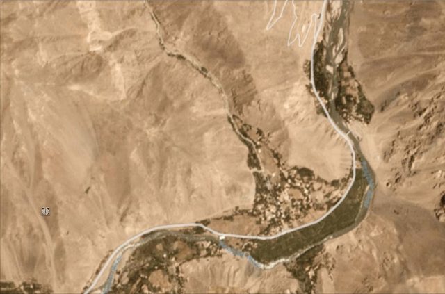
The community of Pashgor struck by the debris flow on 12th July 2018 in Panjshir Province, Afghanistan. Image, dated 11th July 2018, via Planet Labs, used with permission.
.
This image shows the aftermath – the track of the debris flow, and the vast amount of new sediment in the main channel, are clear:-
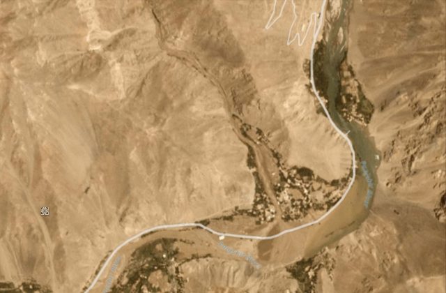
Planet Labs imagery, dated 12th July 2018, of the aftermath of the debris flow in Panjshir province, Afghanistan. Image via Planet Labs, used with permission.
.
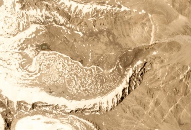
It is not clear to me as to whether the channel is completely blocked. There is some chance that this might be the case. But the imagery allows the course of the debris flow to be tracked upstream to find the source. This lies about 10 km to the north as the crow flies, probably 15 km via the channel. The source is at 35.47 N, 69.64 E if you are interested in looking at Google Earth. At this location, at an elevation of about 4500 metres, we find this lake on the imagery before the disaster:-

The ephemeral lake in the mountains of Panjshir province, which caused the debris flow disaster on 12th July 2018. Image via Planet Labs, used with permission
.
The image of the following day shows that the lake had completely drained, generating the debris flow that destroyed the village:-
Planet Labs image dated 12th July 2018 showing the drained ephemeral lake that caused the debris flow of 12th July 2018 in Panjshir province. Image, dated 12th July 2018, courtesy of Planet Labs, used with permission.
.
The lake was about 400 metres long and 150 metres wide. Interesting it was not present at any point last summer as far as I can tell, so it is likely to have been formed by temporary blocking of the valley by ice and/or debris (can anyone provide any insight into this process? I am assuming that this was probably an ice dam?).
Afghanistan is of course no stranger to landslide disasters. It is somewhat frustrating to see some news agencies illustrating articles about this event with imagery from the dreadful Abe Barek landslide in May 2015.
Reference
Planet Team (2017). Planet Application Program Interface: In Space for Life on Earth. San Francisco, CA. https://api.planet.com
 Dave Petley is the Vice-Chancellor of the University of Hull in the United Kingdom. His blog provides commentary and analysis of landslide events occurring worldwide, including the landslides themselves, latest research, and conferences and meetings.
Dear Dave, It was a Jökulhlaup (an arid variation!): In this case the collapse of a supraglacial lake over a debris covered glacier, probably by breaking down an ice barrier due to an excess of hidrostatic pressure. It did not happened before probably because the well visible supraglacial hollow that hosted the lake (sometimes described as thermokarst) it is large and only with excessive snow melt could reach the critical depth to overcome the needed pressure to lift the mix of glacier ice and debris. In fact your last image shows that the lake exceeded the size of the hollow that in many older images showed accumulation of water, but with smaller area covered by it. I cannot send you the images that prove this, but I posted a comment in twitter with an image edited showing the glacier characteristics. It is what we locally call complex glacier system as it shows the transition form a ice-exposed part to a debris-covered ice and then into a rock.glacier, which due to its larger debris concentration cannot be floated, but there are case where ice concentration of rock glaciers in Chile reach 99%. regards.