21 June 2018
Hidroituango: Renewed movement suggests a landslide of up to 200,000 cubic metres may occur soon
Posted by Dave Petley
Hidroituango: Renewed movement suggests a landslide of up to 200,000 cubic metres may occur soon
News reports suggest that there is an increase in movement on the slopes above the lake at Hidroituango. This is being interpreted by those responsible for monitoring at the site as indicating that a landslide in the range of 100,000 to 200,000 m³ may occur in the next few days. RCN Radio reported last night that workers have now been evacuated from the site in anticipation of the slip. However, there has not been a need to trigger new evacuations of the communities downstream over and above the 2,500 families that remain in emergency shelters.
A landslide of up to 200,000 m³, whilst large, is not being considered as being sufficient to endanger the integrity of the dam, and nor is it expected to generate a wave of sufficient magnitude to trigger an overtopping event. In the last two weeks the level of the lake has dropped by seven metres as drier conditions affect the catchment. The reduced head of water has led to a decrease in the flow through the dam itself.
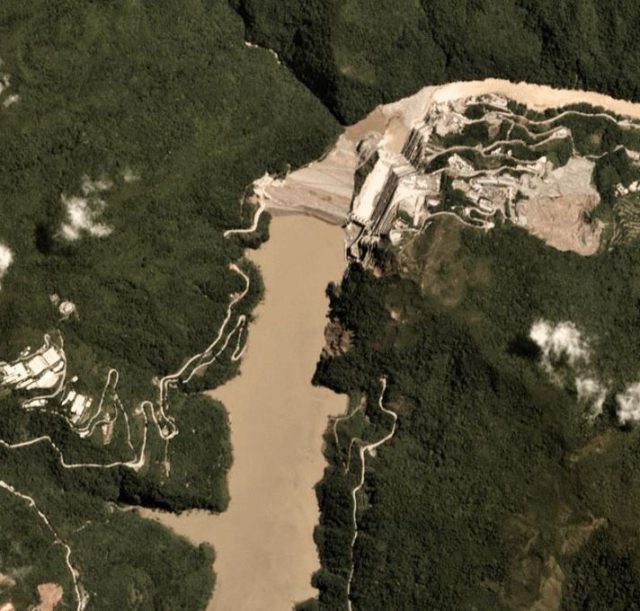
The image below shows a Planet Labs image collected yesterday (20th June 2018) of the Hidroituango dam site. The location of the anticipated landslide is not clear, but the reduced level of the lake is apparent:-

Planet Labs image of the Hidroituango dam site. Image collected on 20th June 2018, used with permission.
.
EPM now expects to bring the situation under control by October, allowing restoration works to begin to bring the site back to a state that provides complete control of the lake level, and ultimately that provides the capability to generate power. However, that is likely to require considerable work given the level of damage and the effects of the emergency works.
Reference
Planet Team (2017). Planet Application Program Interface: In Space for Life on Earth. San Francisco, CA. https://api.planet.com


 Dave Petley is the Vice-Chancellor of the University of Hull in the United Kingdom. His blog provides commentary and analysis of landslide events occurring worldwide, including the landslides themselves, latest research, and conferences and meetings.
Would be interesting to compare against the much larger Vajont disaster of 1963.
[The landslide at Vajont had a volume of >200 million cubic metres, and so was about 1000 times larger than this potential failure. D]
3VGeomatics is providing SatSAR and a GroundProbe terrestrial radar is onsite monitoring some aspect of the issue.
I’d like it to be an IDS Georadar IBIS unit, but at least they have something and they should be way out in front of any real issue with this instrumentation in place.
john