
19 December 2018
Revisiting the landslides from the Mw=7.5 earthquake in Papua New Guinea on 25th February 2018
Revisiting the landslides from the Mw=7.5 earthquake in Papua New Guinea on 25th February 2018
Back in the early part of 2018 I posted on a number of occasions about the significant landslides triggered by the 25th February Mw=7.5 earthquake in Papua New Guinea. That event was efficient at generating landslides, and it is likely that a substantial proportion of the fatalities from the earthquake were related to the multiple slope failures. The response of the international community to this disaster has been disappointing, which has meant that it has been difficult to ascertain the true landslide impacts.
At the time it was difficult to piece together the overall effects of the landslides because satellite imagery was marred by the extensive cloud cover. In the months since it has been possible to get a better impression. This is a Planet Labs image of the river affected by landslides near to Komo Station, collected on 12th November 2018:-
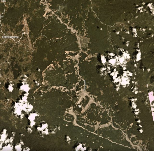
Landslides triggered by the 2018 earthquake in Papua New Guinea. Planet Labs image, collected on 12 November 2018. Copyright Planet Labs, used with permission.
.
It is worth looking at just a part of this image in more detail:-
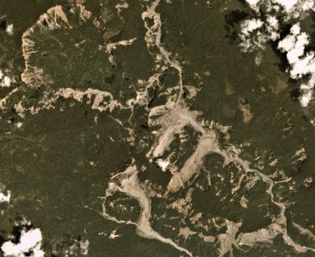
Detail of some of the landslides triggered by the 2018 earthquake in Papua New Guinea. Planet Labs image, collected on 12 November 2018. Copyright Planet Labs, used with permission.
.
The extensive failure of the steep scarp in the northeast of the image is interesting – I guess this illustrates the strong role that slope gradient plays in determining slope failure, plus there may be an element of topographic amplification here too. The large flow failure on the southern part of the image is also notable this is over 2.5 km in length. Along the river there is a series of significant failures, several of which are over 1 km long. And of course there are multiple smaller failures too.
Reference
Planet Team (2018). Planet Application Program Interface: In Space for Life on Earth. San Francisco, CA. https://www.planet.com/.
18 December 2018
Loch Quoich landslide: an interesting and disruptive failure in the Highlands of Scotland
Loch Quoich landslide: an interesting and disruptive failure in the Highlands of Scotland
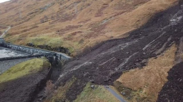
On 10th November a significant landslide occurred at Loch Quoich near Kinloch Hourn in the Highlands of western Scotland. The Highland Council has a really good update on this landslide on their webpages, which includes this image:-
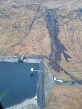
The landslide at Loch Quoich in the Highlands of Scotland. Image via the Highland Council.
.
This landslide, which has a reported mass of about 9,000 tonnes, extends over a distance of about 1 m. The slip has blocked the road across the slope and also caused operations at the dam to be shut down as a result of debris accumulation in the spillway. The landslide destroyed a pylon, cutting the electricity supply to 20,000 homes, as well as destroying telephone cables. Services have now been restored, but the road remains closed and will not reopen prior to mid 2019.
The best images of the landslide can be found in a drone video that has been posted online to Vimeo by the power company SSEN. The quality of the imagery is fantastic. You may or may not be able to view it below; if not then follow this link:
.
This video gives an amazing view of the structure of the landslide. So, starting from the top, this is the source area:-
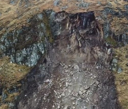
The source area of the Loch Quoich landslide in Scotland. Still from a drone video posted by SSEN.
.
The landslide appears to have initiated through a toppling failure of the rock bluff. Note the very obvious fault running through the middle of the outcrop. The initial failure has entrained a large volume of material from the upper part of the slope to generate a substantial failure. The upper portion of this entrainment zone can be seen below:
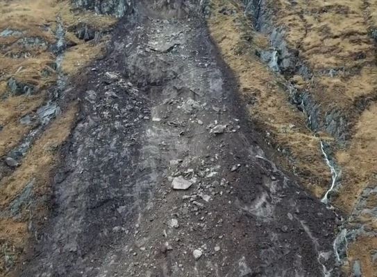
The entrainment zone of the Loch Quoich landslide in Scotland. Still from a drone video posted by SSEN.
.
Further down the slope the mechanism changes to deposition (with some erosion in the channels):-
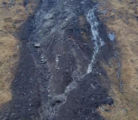
The transition from the entrainment zone to the deposition of the Loch Quoich landslide in Scotland. Still from a drone video posted by SSEN.
.
Below this the landslide has deposited a comparatively thin mass over a large area. Note the destroyed pylon. It is interesting that the deposit was able to cross the spillway:-
The lower part of the of the Loch Quoich landslide in Scotland. Still from a drone video posted by SSEN.
.
17 December 2018
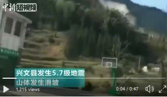
Luopu Village: an interesting landslide triggered by a M=5.7 earthquake in Sichuan yesterday
Luopu Village: an interesting landslide triggered by a M=5.7 earthquake in Sichuan yesterday
At 12:46 pm local time yesterday (Sunday 16th December 2018) a shallow (12 km) M=5.7 earthquake struck Sichuan Province in China. This earthquake, which Xinhua reports had an epicentre at 28.24, 104.95, is not reported to have caused any loss of life, although at least 16 people were injured. At present the impact of the earthquake is unclear – it is likely to have caused damage over a comparatively small area, but ECNS has a very interesting image of a landslide apparently triggered by the earthquake:-
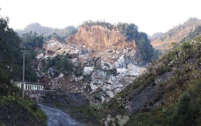
Luopu village – a landslide triggered by the M=5.7 earthquake on 16th December 2018. Image via ECNS
.
This appears to be a large rock topple, possibly with a sliding component (is there an inclined basal surface extending from the toe of the cliff?). Movement appears to have occurred in massive limestone blocks. The detachment surface at the rear of the landslide appears to be an existing joint, and is heavily weathered.
China News also tweeted a video taken in the immediate aftermath of the earthquake, which appears to show the dust plume generated by a landslide:
A dust cloud in the immediate aftermath of the M=5.7 earthquake in Sichuan Province yesterday. Still from a video tweeted by China News
.
It is not clear as to whether this is the same location as the landslide highlighted above. Later on the video also shows some substantial boulders blocking a rural road:-

Boulders blocking a rural road in Xingwen County in Sichuan Province in the immediate aftermath of the M=5.7 earthquake in Sichuan Province yesterday. Still from a video tweeted by China News
.
Whilst widespread damage from n earthquake of this magnitude is unlikely, local high peak ground accelerations can occur. In an area with rugged terrain such as this, some landslides are probably inevitable.
14 December 2018
The Nyixoi Chongco rock avalanche in Tibet
The Nyixoi Chongco rock avalanche in Tibet
In a new paper in the journal Landslides, Wang et al. (2018) describe the Nyixoi Chongco rock avalanche in Tibet. I have not seen this spectacular rock avalanche in the literature before this paper; it is an excellent addition to the inventory of such events. The dry, low vegetation environment of the Tibetan Plateau has meant that the rock avalanche is beautifully preserved in the landscape. Whilst the paper itself is a little vague on the exact location, I have managed to track it down to 29.534, 90.263, a spot that has excellent Google Earth imagery:-
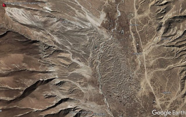
Google Earth imagery of the the Nyixoi Chongco rock avalanche in Tibet
.
According to Wang et al. (2018), the Nyixoi Chongco rock avalanche involved a mass of 28 million cubic metres descending a vertical distance of 885 metres, and traveling a total of 4.6 km horizontally, representing exceptional mobility. The landslide deposit is about 50 metres thick. The authors do not give an estimated age for the rock avalanche, nor a definite trigger mechanism, but the proximity to active faults makes them suspect that an earthquake might have been involved. Wang et al. (2018) note that a nearby fault is thought to have generated a magnitude 7.0 earthquake about 2,200 years BP; this would have induced sufficiently intense shaking to have triggered a rock avalanche of this type.
The Nyixoi Chongco rock avalanche can be better appreciated in this Google Earth oblique view:-
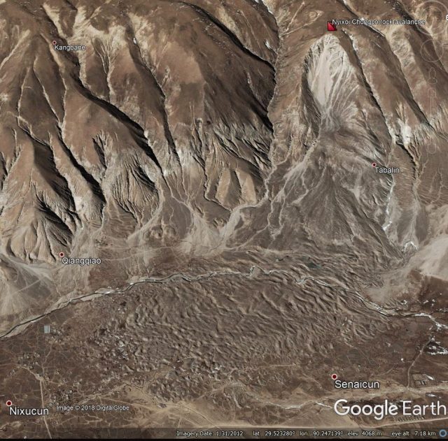
Google Earth perspective view of the Nyixoi Chongco rock avalanche in Tibet
.
I have placed the marker at the crown of the landslide scar, which has a scoop morphology. Below this is a very clear transportation zone, stripped by the passage of the landslide. The deposit starts from the foot of the slope and extends down the valley. Note the clear hummocks in the landslide mass, which are very common for large rock avalanches. Wang et al. (2018) note that the landslide has many of the common characteristics of large rock avalanche masses, including a very coarse (i.e. boulder-rich) carapace (the surface layer), and a highly fragmented main landslide mass. The base of the landslide mass shows almost no mixing with the valley deposits, and has sedimentary structures that suggest that these deposits were unsaturated when the landslide was deposited. The authors suggest that the movement of the landslide was not associated with any of the complex mechanisms sometimes postulated for these huge rock avalanches, in this case involving simple shear between the landslide mass and the valley floor.
It is interesting to note that this means that the landslide could have high mobility without needing liquefaction or anything more exotic, a finding that is important in the context of understanding other large events.
Reference
Wang, YF., Cheng, QG., Shi, AW. et al. 2018. Sedimentary deformation structures in the Nyixoi Chongco rock avalanche: implications on rock avalanche transport mechanisms. Landslides https://doi.org/10.1007/s10346-018-1117-7
13 December 2018
InSARNORWAY: a national deformation map for Norway
InSARNORWAY: a national deformation map for Norway
Late in November the Geological Survey of Norway launched InSARNORWAY, a new national level deformation map for the whole of the country. This is, as far as I know, the first such national level project, although there have been some proof of concept studies previously. The new map uses multiple epochs of InSAR data (satellite radar data) to generate a map of deformation, accessible via a free web portal. The resource allows the user to map the deformation and to generate graphs of change through time. It is fascinating and exciting.
One of the questions that we have been pondering for a while is the degree to which all rock slopes deform through time, and how fast these rates might be. Sitting below that are nested questions, such as the geological controls, the effects of weather and the evolution of failure. A resource of this type allows us to start to answer these key questions. As an example, I was browsing the maps, and came across this area of deformation near to Aarset (location 62.198, 7.217):-
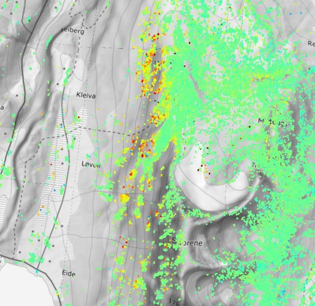
An area of apparent active deformation near to Aarset in Norway, mapped using the InSARNORWAY tool.
.
Here the warm colours are areas of more active deformation. The data suggest that on the west side of a mountain in this area there is some active movement. This is the Google Earth imagery of the same area:-
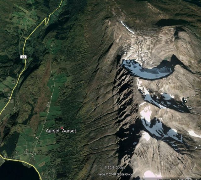
Google Earth imagery of the area near to Aarset in which the InSARNORWAY data suggests active movement is occurring
.
And this is the plot of the data from one of the points in this area:-
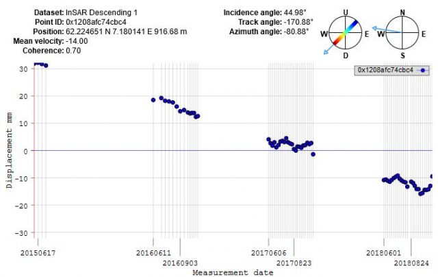
InSARNORWAY data for active deformation near to Aarset in Norway.
.
So the InSARNORWAY data suggest that the over the course of 38 months the slope has moved about 50 mm downwards and towards the west. This is entirely logical in terms of the configuration of the slope. So, on the face of it this appears to be a creeping rockslope. That is not to say that it is dangerous in any way, this is type of creeping behaviour probably quite normal for large, steep rockslopes and so is no cause for alarm. The rate appears to be quite linear with time – again this is not unexpected. But for the first time it is possible to characterise this behaviour over a large area.
Wow!
This of course creates a capability to identify large numbers of creeping rockslopes. It is likely that, in most cases, prior to a large event they will go through a phase of acceleration, so systematic monitoring (perhaps with artificial intelligence) could allow this to be detected. And of course using InSARNORWAY we can now start to understand what is “normal” creep across large areas, allowing us to understand and determine when behaviour is changing.
InSARNORWAY is an extraordinary and very exciting development. I would love to see similar resources for other countries.
12 December 2018
Fenshui, China: a fatal landslide, caused by humans?
Fenshui, China: a fatal landslide, caused by humans?
On Sunday a rock slope failure affected an area of Fenshui township in Xuyong County, Sichuan Province in China, killing five people and injuring a further seven. The landslide, which happened in a period of heavy rainfall, destroyed a number of residential properties.
Xinhua has quite a number of images of the aftermath, most of them focusing on the heroic actions of the government rescue teams, which is quite normal in the Chinese state media. Asia One has a much more interesting image of the landslide site:-
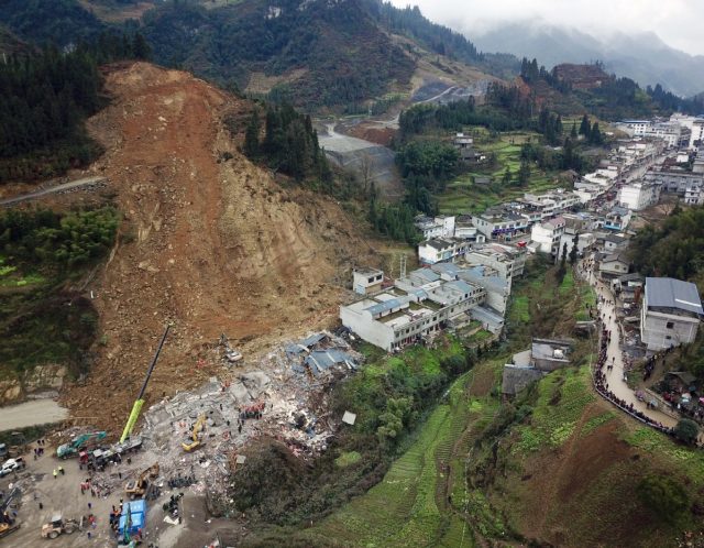
The fatal landslide at Fenshui in Xuyong, China on Sunday 9th December 2018. Image via China Daily / Asia News Network and Asia One.
.
The landslide appears to have occurred in quite intensely weathered rock. The main scar originated high on the slope, which appears to the seat of the failure. The landslide has entrained some slope materials en route, though it seems to me that the volume of debris at the slope toe is quite modest. And note also that the properties appear to have collapsed, perhaps as a result of impacts, rather than being buried. This is probably the reason why the proportion of victims of the landslide that survived was quite high for a landslide event.
Most interesting to me is that the slope appears to be traversed by a road about a third of the way from the top. The construction on the right side of the image suggests that this is quite new. The toe of the failure of the slope appears to me to coincide with the level of the road. I wonder if this slope was cut prior to the landslide and, if so, whether this was a factor in the events? Poor road construction techniques often lead to landslides.
10 December 2018
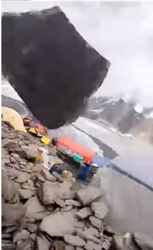
Spatnik basecamp – that was close!
Spantik basecamp – that was close!
In August Shanyan Anwer posted the following video onto Youtube, showing an extraordinary near-miss for a camp, and its occupants, from a large boulder. The owner of the video is Shayan Anwer, who posted it on Twitter:-
.
Near-misses do not come much more near than that. The video was apparently shot at Spantik basecamp, located between Baltistan and Hunza in northern Pakistan. In fact the video, which is very short, is worth closer inspection. Early in the video the boulder can be seen heading down the slope towards the camp:-
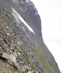
The first sign of the boulder at Spantik basecamp. Still from a Youtube video. The video is by Shayan Anwer.
.
Just how close this rock came to the camp, and the person holding the camera, can be seen here:-
The boulder as it flew over the camp at Spantik basecamp. Still from a Youtube video. The video is by Shayan Anwer.
.
Next of course it comes terrifyingly close to another person:-
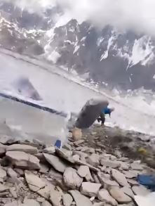
A very near miss for a person at Spantik basecamp. Still from a Youtube video. The video is by Shayan Anwer.
.
This video does emphasise a few points about rockfalls. The boulder is tabular in shape, which in some circumstances can generate extreme mobility. This happens when the boulder starts to rotate around its shortest axis, behaving like a wheel. In such conditions boulders are comparatively stable, skipping down the slope in large bounces. As the boulder itself is uneven, and the surface is very rough, the path is somewhat unpredictable. In this case the boulder appears to bounced away from the people located downslope of the camera, in part because it struck softer debris, which absorbed some of the energy of the rock.
There is little doubt that this was a very lucky escape. That boulder could have struck any of the people or any of the tents.
Acknowledgement
Thanks to Fabien for pointing this one out to me. I had somehow missed it during the summer! It is a remarkable video. The video is by Shayan Anwer. Thanks to Komal Uzair for providing information about the origin of the film.
7 December 2018
The Guazi landslide: an interesting ancient landslide reactivated by a hydroelectric power scheme in China
The Guazi landslide: an interesting ancient landslide reactivated by a hydroelectric power scheme in China
An interesting article in the journal Landslides (Zhao et al. 2018) highlights the Guazi landslide in Heishui County, Sichuan, China. This is a large, ancient landslide located sandstone and phyllite rocks in mountainous terrain on the slopes above the Heishui River. In 2008 a major hydroelectric power scheme was developed downstream of the landslide site, consisting of the Maoergai Dam, a rock-filled embankment dam providing a hydraulic head of about 170 metres, and associated infrastructure. The dam was completed on 20th March 2011, and impoundment of the reservoir was started. On 2nd September 2011, six months after impoundment was initiated, movement of the Guazi landslide was noted.
The current state of the Guazi landslide can be seen in the Google Earth oblique image below:
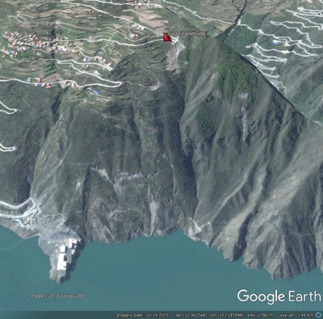
Google Earth oblique image of the Guazi landslide in Sichuan, China. Image dated October 2015
.
The landslide is about 950 metres from the crown of the ancient slide (marked with the landslide symbol) to the water level, and it is about 550 metres wide. According to Zhao et al. (2018), the ancient landslide has a volume of about 13.5 million m3, with a depth of up to 65 metres. The landslide is marked by tension cracks at the crown, which appeared to widen during the 2008 Wenchuan earthquake. The authors interpret it as a creeping landslide prior to the construction of the dam.
The reactivation in 2011 occurred on the lower slopes, creating a new, very large tension crack. Zhao et al. (2018) provide the following annotated diagram to illustrate both the ancient landslide and the reactivated lower portion. The displacement across the new tension crack is marked as the dislocation zone:-
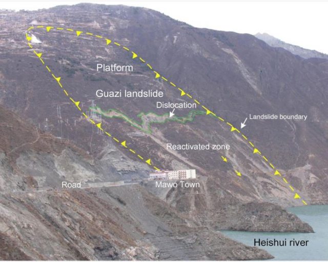
Annotated photograph of the Guazi landslide in China, from Zhao et al. (2018)
.
Interestingly, I would place the crown of the ancient landslide further upslope than the annotated photograph suggests, but the higher feature may be a secondary slide on the rear scarp. Zhao et al. (2018) note that the landslide reactivated during the first phase of impoundment through to December 2011, primarily in the lower third of the slope. In some places the tension cracks are now 20 metres wide. The slide has been monitored since late 2011; the paper reports that in the period from then to September 2012 some parts of the landslide moved a further 30 cm or so. Measurement using inclinometers suggest that the movement is quite shallow. The upper section of the landslide shows little additional movement.
Zhao et al. (2018) note that at the moment the landslide does not show signs of a larger scale reactivation. But, they note that:
“At present, the Guazi landslide is stable overall; however, confirming its stability in the future is difficult, and long-term monitoring is necessary”
I agree wholeheartedly. In a translational, flexural toppling landslide such as this movement of the toe is likely to be progressively destabilising the system through time. This does not mean that a large-scale reactivation is inevitable, but it cannot be ruled out. And of course this is yet another example of an unanticipated major landslide at a hydroelectric dam project.
Reference
Zhao, B., Wang, Y., Wang, Y. et al. (2018). Triggering mechanism and deformation characteristics of a reactivated ancient landslide, Sichuan Province, China. Landslides https://doi.org/10.1007/s10346-018-1111-0
5 December 2018
Malibu: Planet Labs images of the first round of mudflows
Malibu: Planet Labs images of the first round of mudflows
One of the potentially disastrous impacts of the recent wildfires in California is the vulnerability of the now bare soil to highly destructive mudflows. Similar processes have been seen elsewhere in California, and indeed worldwide. The fires have occurred at the start of the period in which extremely heavy rainfall, associated with atmospheric river events, can occur. The potential impacts are serious.
Planet Labs have captured a high resolution SkySat image of a part of Malibu following the Woolsey fire and then the heavy rainfall last week. They have kindly provided three images of the area. The first image, collected on 31st August 2017, predates the fire:-
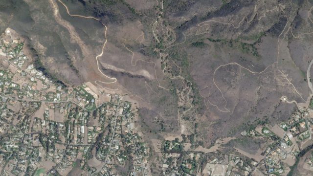
Planet Labs SkySat image of a part of Malibu prior to the fire on 31st August 2017. Image copyright of Planet Labs 2018, used with permission.
.
The second image was collected on 28th November 2018, after the fire:-
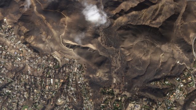
Planet Labs SkySat image of a part of Malibu after the fire on 28th November 2018. Image copyright of Planet Labs 2018, used with permission.
.
The extensive fire damage to the vegetation in the hilly area is very clearly seen. This is this damage that has made the area vulnerable to heavy rainfall. Finally, this image shows the same area after the first round of heavy rainfall:-
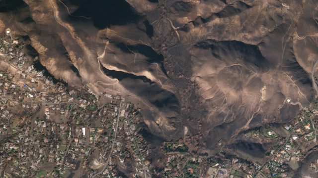
Planet Labs SkySat image of a part of Malibu after the first round of heavy rainfall, collected on 1st December 2018. Image copyright of Planet Labs 2018, used with permission.
.
The image shows extensive stripping of top soil by the heavy rainfall, and the formation of gullies, especially on the right side of the image. This is a more detailed image of this area:-
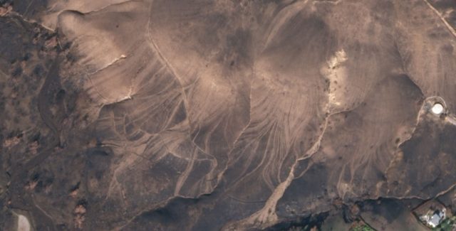
Detail of a Planet Labs SkySat image of a part of Malibu after the first round of heavy rainfall, collected on 1st December 2018. Image copyright of Planet Labs 2018, used with permission.
.
This is a remarkable image, showing extensive shallow stripping and gullying, with the gullies providing direct connection to the river channels. The ways in which huge numbers of small flow structures all connect to the same channel provides the potential for the massive downslope impacts.
The climate emergency (sometimes less well described as climate change) is very much in the news, and the landslide community is worrying about he impacts on mass movements. This example is a beautiful, tragic illustration of the problem – increased drought is increasing the risk of forest fires; increased rainfall intensities then allow more dynamic mobilisation of the debris to form mudflows.
Reference
Planet Team (2018). Planet Application Program Interface: In Space for Life on Earth. San Francisco, CA. https://www.planet.com/. Especially thanks to Robert Simmon for his work on the images,
1 December 2018
First images of slope failures triggered by the M=7.0 Alaska earthquake
First images of slope failures triggered by the M=7.0 Alaska earthquake
The M=7.0 Alaska earthquake on 30th November 2018 was sufficiently large to trigger some slope failures, even though it was comparatively deep (41 km). Such an earthquake would be expected to generate shaking over a large area, but probably with reasonably modest peak ground accelerations. The USGS ground failure model suggests that only a small area might have been subjected to slope failures, but much of the area affected had limited potential for large-scale landslides due to the low relief topography:-
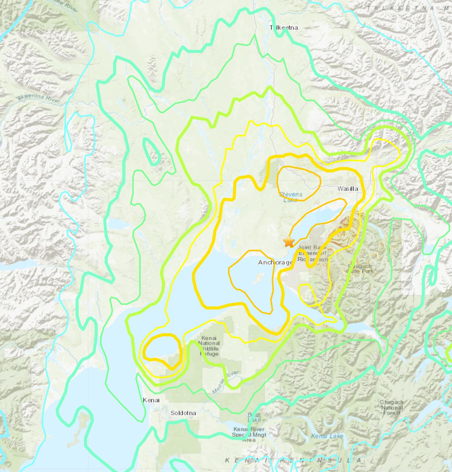
USGS map of landslide potential from the M=7.0 Alaska earthquake
.
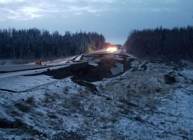
There may be some landslides to the east of the epicentre in the rugged terrain there. Some images of slope failures have started to emerge though. @AOC-Security has tweeted this image of a lateral spread affecting a road embankment on Vine Road in Wasilla:-
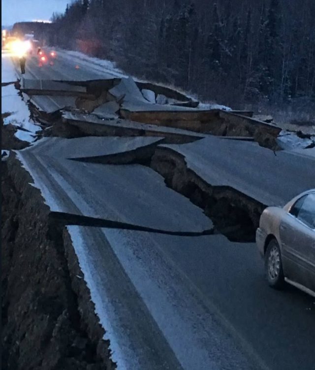
An apparent lateral spread, triggered by the Alaska Earthquake affecting Vine Road in Wasilla . Image tweeted by @AOC-Security
.
Meanwhile David Ruffini has tweeted an image of the same feature in daylight:-
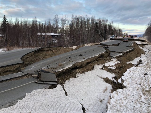
An apparent lateral spread, triggered by the Alaska Earthquake affecting Vine Road in Wasilla . Image tweeted by David Ruffini.
.
This lateral spread has been caught in a spectacular airborne image by Marc Lester:-
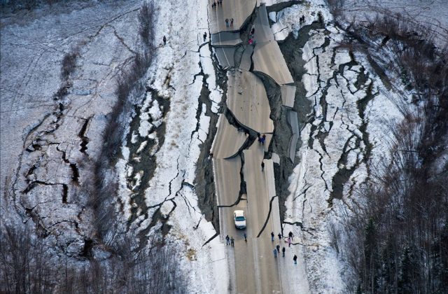
A sensational image by Marc Lester showing a lateral spread triggered by the Alaska Earthquake.
.
Josh Bierma tweeted an image of another apparent lateral spread affecting a road:-
A lateral spread, triggered by the Alaska earthquake, affecting a highway. Image tweeted by Josh Bierma
.
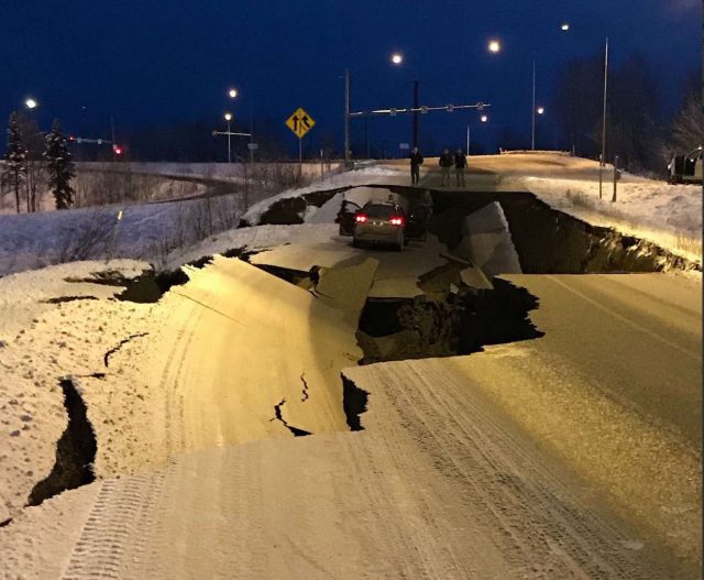
That event could have been far worse for the occupants of the car. And Ryan Hobbs tweeted an image of yet another such lateral spread affecting a highway:-
A lateral spead triggered by the Alaska earthquake. Image tweeted by Ryan Hobbs.
.
Ryan Hobbs has also tweeted an image of rockfalls affecting a road in the earthquake affected area:-
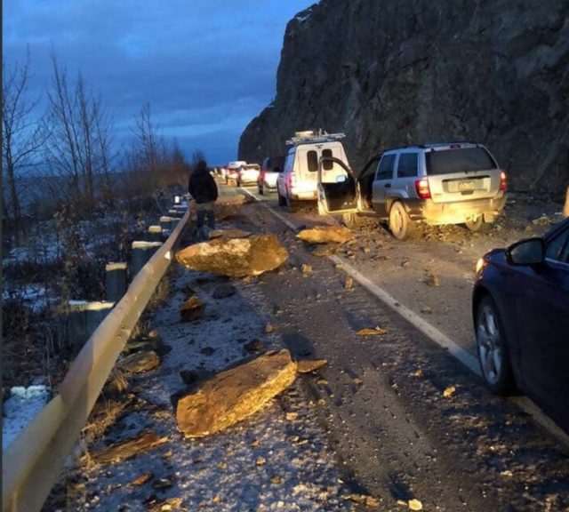
Rockfalls triggered by the Alaska earthquake. Image tweeted by Ryan Hobbs.
.
 Dave Petley is the Vice-Chancellor of the University of Hull in the United Kingdom. His blog provides commentary and analysis of landslide events occurring worldwide, including the landslides themselves, latest research, and conferences and meetings.
Recent Comments