
4 January 2019
The ten most important landslide events of 2018
The ten most important landslide events of 2018
2018 will be remembered as a year of destructive landslide events. This is my personal list of the ten most important ones over the course of the year. There are so many to choose from; comments welcome on whether I have the correct ten:-
10. Continued mining-induced landslides in Hpakant, Myanmar
The dreadful problem of major human-induced landslides in the jade mining areas of Hpakant in Myanmar was once again a major issue in 2018. The latest major event occurred in September. There have been fatalities throughout the year, meaning that at least 807 people have been killed in landslides there since 2015. There is no excuse for this level of loss.
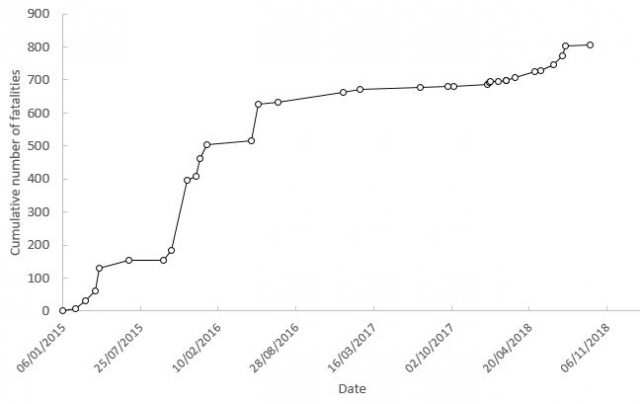
The recorded number of landslide related fatalities in the Hpakant area of Myanmar since January 2015
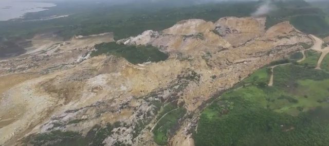
9. The dam landslides in Ituango in Colombia
The disastrous landslides that rendered the Hidroituango dam temporarily (at least) redundant, and which induced huge downstream flooding, in Colombia in May were a major issue. Economically this may be one of the most disastrous landslide events of the year. I suspect we will hear more of this project in 2019; it once again illustrates the perils of landslides for hydroelectric schemes. As we build in increasingly challenging areas, including those that are tectonically active, it feels inevitable that we will see another major landslide disaster in the years ahead.
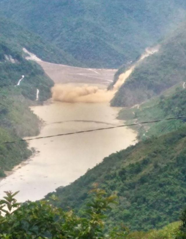
A landslide at the Hidroituango site in Colombia. Image via the Global Forest Coalition.
.
8. The Montecito mudflows in California
The Montecito mudflows in January, triggered by heavy rainfall after the terrible wildfires in California in 2017, cost 23 lives and insured losses of $500 million or so. These landslides are probably prophetic; as the climate continues to warm the occurrence of devastating wildfires will increase, and mudflows inevitably follow. We will see more of these in 2019.
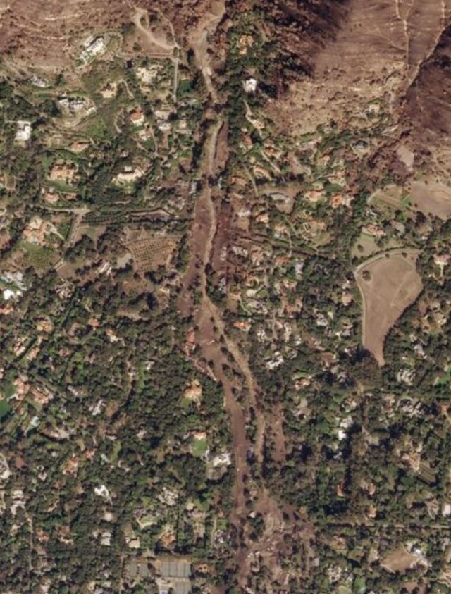
Planet Labs image of the damage caused by the Montecito debris flows.
.
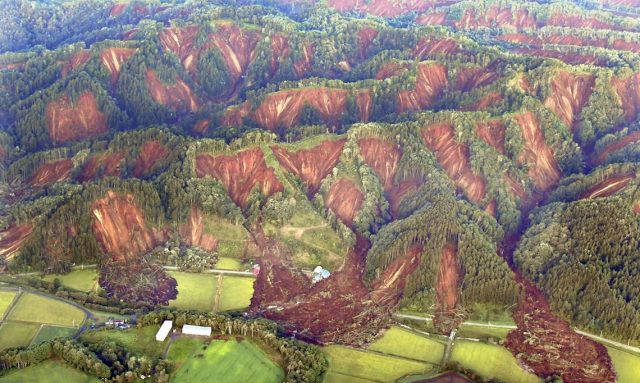
7. The rainfall-induced landslides in Hiroshima, Japan
The dreadful rainfall-induced landslides in the Hiroshima area of Japan in July 2018 induced extensive damage. At least 104 people were killed in landslide events, and there were over 120 fatalities when the impacts of the associated flooding are included. That a country that is so prepared for landslides can suffer this level of loss was a surprise to many. It is a clear demonstration that physical management of landslides has limits, and the increasing intensity of rainfall associated with climate change will mean that these limits are tested repeatedly. This places huge emphasis on the importance of building resilience.
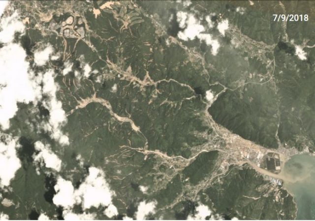
Planet Labs imagery of the aftermath of the landslides at Yasuuracho Chuo, near to Hiroshima, in Japan.
6. The mining-induced landslide at Naga in Cebu, Philippines
The huge mining-induced landslide at Naga City in Cebu in the Philippines was truly astounding. This is another case in which the warning signs were clear ahead of the failure; that they were ignored led to 83 fatalities. Mining-induced landslides are on the rise. That we are losing so many lives to preventable mining continues to be a global disgrace.
The Naga City landslide in the Philippines. Image via Youtube.
.
5. The Berangay Ucab landslide in the Philippines
Sadly in fifth place is yet another landslide in the Philippines. In this case it was a rainfall-induced failure onto a dormitory at Barangay Ucab, triggered by a typhoon. This slide serves to illustrate the challenges of reducing landslide risk in poor, mountainous areas, especially those disturbed by deforestation and mining. In total, 102 people lost their lives at Barangay Ucab.
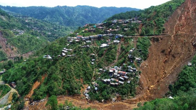
The Barangay Ucab landslide in the Philippines. Drone image posted to Twitter by Mohammed Abdiker.
.
4. Landslides triggered by the Hokkaido earthquake in Japan
The 6th September 2018 Hokkaido Iburi-Tobu earthquake triggered huge numbers of landslides over a comparatively small area. Initial technical reports suggest that over 6,000 landslides were triggered ,killing 36 people (the earthquake killed 41 people in total).
The area of intense landslides from the 6th September 2018 Hokkaido earthquake. Image via Tokyo Keizai.
.
3. Landslides triggered by the Papua New Guinea earthquake
The most under-reported landslide disaster of the 2018 was the 25th February 2018 Papua New Guinea earthquake, which triggered extensive landsliding. The response from the international community was slow and under-powered, and even now it is hard to ascertain the true extent of the losses. In the major river channels the landslides were extraordinary:-
.
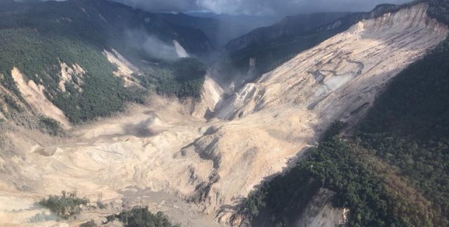
An extremely large planar rockslide in Papua New Guinea. Image posted on Facebook by Bernard James McQueen.
.
2. The Anak Krakatau landslide and tsunami in Indonesia
The Anak Krakatau flank collapse is fresh in the memory. Over 420 people are known to have died in the tsunami that the collapse triggered. This morning there are reports that new deformation has been detected in the remainder of the volcano. Understanding the sequence of events that led to the generation of this tsunami is going to be an important topic in the months ahead.
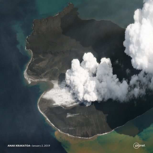
Planet Labs SkySat image of the aftermath of the Anak Krakatau landslide in Indonesia. Image captured on 2nd January 2019.
1. The Palu earthquake – three flowslides and a landslide-induced tsunami in Indonesia
The largest landslide disaster of 2018 was undoubtedly the Sulawesi earthquake, and its disastrous impacts on the town of Palu and its suburbs. The jury is still out on whether the tsunami was triggered by underwater landslides; I suspect this will be a hot topic in the months ahead. The three major flowslides caused the highest level of loss, with at least 1600 fatalities in Balaroa and 600 at Petobo for example. The old maxim has always been that it is not earthquakes that kill people, it is buildings that cause the loss of life. This event illustrates the folly of taking that too seriously – in 2018 we have seen repeated examples in which landslides have been the major cause of fatalities in earthquakes. I wonder when we will start to learn this lesson?
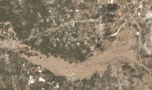
The Tinggede landslide on the outskirts of Palu. Image via Planet Labs, used with permission.
.
And finally, The Landslide Blog
The Landslide Blog celebrated its 11th birthday in December, and it also marked eight years since I moved to the AGU blogosphere. In 2018 I posted 156 different articles on this blog, and in return 258,561 different people have been to call, making 411,509 individual visits (clearly many of you come back). You have looked at 560,113 pages between you all. Many thanks for your continued support, I very much appreciate the discussions that we have about interesting landslides around the world. You teach me new things every time.
And thanks of course to the AGU, and to LarryO’, for hosting the blog, and to Planet Labs for giving me access to their imagery.
3 January 2019
Anak Krakatau: Planet Labs imagery of the aftermath of the landslide
Anak Krakatau: Planet Labs imagery of the aftermath of the landslide
Planet Labs has now captured a high-resolution SkySat image of the aftermath of the Anak Krakatau landslide, which generated the deadly tsunami shortly before Christmas. These images are featured on the BBC website too, with an excellent commentary from Jonathan Amos. The images are spectacular, as usual.
So, here is an image collected on 17th December 2018 showing the volcano shortly before the landslide. Note the smoking volcanic cone:-
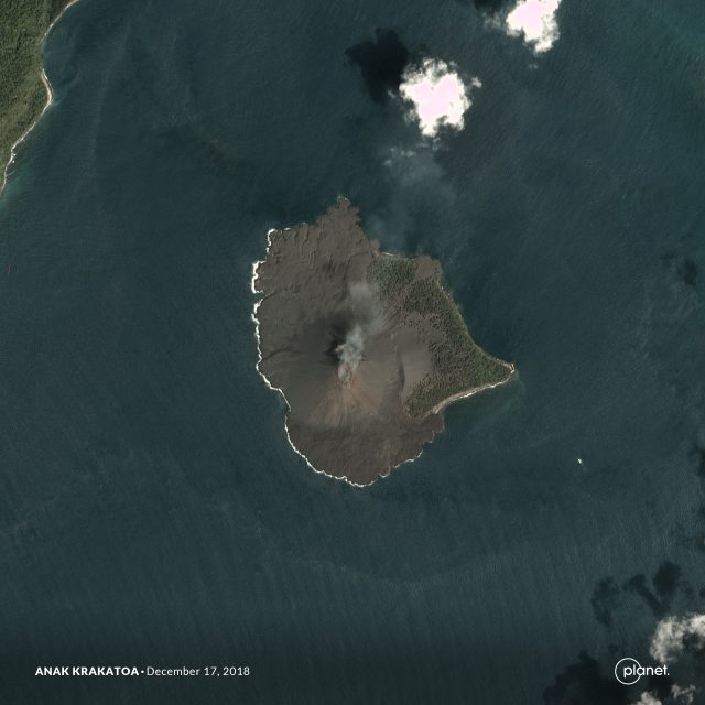
Planet Labs image of Anak Krakatau prior to the landslide
.
I can see no signs of any precursory deformation features on the volcano, which is perhaps a little surprising. The second image shows the volcano after the landslide, in an image captured on 30th December 2018:-
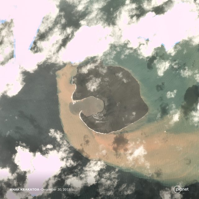
Planet Labs image showing Anak Krakatau after the landslide. Image captured 30th December 2018.
.
This image shows the bowl-shaped landslide scar, and the new, small, bay formed by the collapse. There is a huge amount of sediment in the water around Anak Krakatau. The final image was captured using the SkySat high resolution instrument, providing the best image yet of the aftermath of the landslide:-
Planet Labs SkySat image of the aftermath of the Anak Krakatau landslide in Indonesia. Image captured on 2nd January 2019.
.
So what can we say about the landslide on Anak Krakatau? To me the scar appears to have a bowl shape, suggesting a complex (multi-phase?), possibly rotational (?) slip. However, the toe of the landslide was extremely broad (look at the alignment of the rear scarp on the far side of the scar), meaning that the slide would have been able to displace water across a very large front. Whilst early reports of the landslide were that it was probably submarine, the images are clear that a very large part of it (possibly the largest part) was subaerial (i.e. occurred above sea level). No remains of the landslide are seen – it left almost nothing behind as far as I can see – so the entire volume of 150-170 million cubic metres entered the water. It is unsurprising therefore that it generated a very significant tsunami in the local area.
An interesting aspect is the peninsular left on the southern (nearest) part of the bay, seen in the second image of Anak Krakatau. This is an unusual feature for a landslide scar. Compare the before and after images – is the peninsular composed of harder volcanic rock (lava flow?) rather than the looser cone deposits? So, in this area did the landslide occur primarily in the looser deposits? Or did this peninsular form in the volcanic eruptions immediately after the landslide? Some of the radar imagery might suggest that this is the case?
Comments please from those who know volcanoes well.
Reference
Planet Team (2018). Planet Application Program Interface: In Space for Life on Earth. San Francisco, CA. https://www.planet.com/.
2 January 2019
Sukabumi: an end of year landslide in Indonesia has killed up to 35 people
Sukabumi: an end of year landslide in Indonesia has killed up to 35 people
Sukabumi: Indonesia’s dreadful year of landslide disasters has finished with yet another event. The village of Cimapag in Sukabumi, West Java was struck by a landslide, triggered by heavy rainfall, at 5:30 pm local time on 31st December 2018. Latest reports suggest that 15 bodies have been recovered, with another 20 people reported to be missing.
The best image that I have found of the landslide is on the Sukabumi Update website, which of course is in Indonesian. This has the image below, which provides a panoramic overview of the slide:
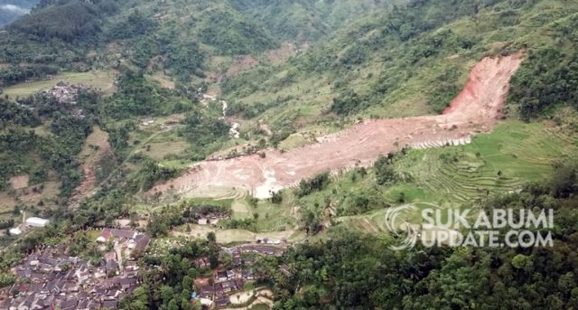
The landslide at Cinabag village in Sukabumi, Indonesia. Image via the Sukabumi Update website.
.
The image was collected by members of the Sukabumi Drone Community. Care is needed as many news reports seem to be illustrated with images of previous landslide events in Indonesia. This landslide appears to be a comparatively deep-seated failure in highly weathered soils, which are normal in Indonesia, and in a steeper section of slope. The landslide appears to have been highly mobile on the lower angled slopes. I wonder if this might be the result of saturated paddy fields, which would provide a saturated, low friction environment. Sukambumi Update also has the image below, a zoom in of the above, providing better detail of the runout zone:-
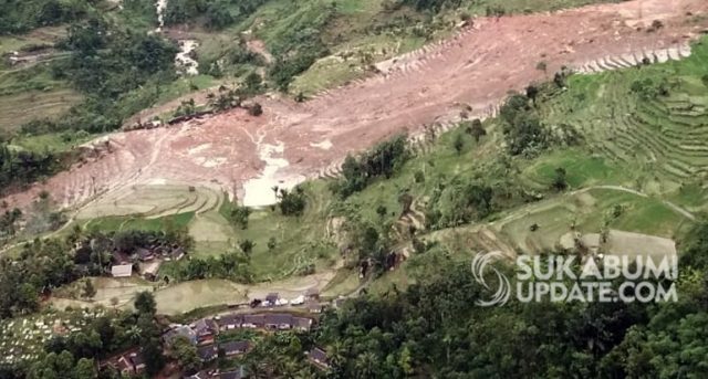
The runout zone of the Sukabumi landslide in Indonesia. Image via Sukabumi Update.
.
West Java is a global landslide hotspot. This map shows the location of landslides that have killed people in West Java in the period 2004 to 2016, using the tool developed by Melanie Froude (see our paper from last year for further details). The combination of volcanic soils subjected to deep weathering, intense rainfall events, extensive deforestation and, of course, a vulnerable population has led to a high level of risk from landslides. The similarity of this landslide to the Dewata tea plantation landslide in West Java in 2010, which killed about 70 people, is notable.
29 December 2018
First visual satellite images of Anak Krakatau show the enormous extent of the landslide
First visual satellite images of Anak Krakatau show the enormous extent of the landslide
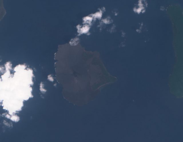
The ESA Sentinel-2 satellite today captured the first visible band imagery of the Anak Krakatau landslide scar. This is the image, from Sentinel Hub:-
ESA Sentinel-2 True Colour image of Anak Krakatau collected on 29th December 2018.
.
For reference, this is an image also collected by Sentinel-2, of the island before the landslide:-
ESA Sentinel-2 True Colour image of Anak Krakatau collected on 1st November 2018.
.
I have tried to improve the Sentinel-2 image to bring out the main features:-
ESA Sentinel-2 True Colour image of Anak Krakatau collected on 29th December 2018.
.
So, there appears to be a huge scar on the west side of the island. This is consistent with the reported deformation from the radar images, as analysed by PVMBG and reported by the BBC. They report that the landslide had a volume of 150-170 million cubic metres, which is a huge landslide. Note that most of the slide was a terrestrial (i.e. above water) slide, not the underwater event that was initially reported. A very substantial proportion of the volcanic cone is missing, including all of the higher elements. PVMBG report that the come elevation has decreased from 338 metres to about 100 metres. Around the southwest part of the island there appears to be an extensive shallow marine deposit – is this landslide material, perhaps moved by the currents, or ash fall from the volcanic eruptions? Or both of course.
It seems likely that this failure was a single large event, although it might have had several phases in short succession. The seismic data, once properly analysed should help with the interpretation of the failure sequence. A key question will be whether INSAR data could have detected precursory deformation of this flank prior to the main landslide event?
28 December 2018
Chaos Jumbles: a fine example of a large volcanic landslide
Chaos Jumbles: a fine example of a large volcanic landslide
In a week in which there is a great deal of interest in very large volcanic landslides, it is worth taking a look at very well-preserved example, Chaos Jumbles in California. This landslide – or more precisely, this set of three large volcanic landslides – lies within Lassen Volcanic National Park in California. There are few large volcanic landslides that are so well preserved and so accessible as this one. As a bonus, the landslides are described in a paper (Eppler et al. 1987) that can be downloaded for free.
The wonderfully named Chaos Jumbles landslides were formed from three collapses of the Chaos Crags dacite volcanic dome complex. The three collapses are all thought to have occurred over a comparatively short time period about 350 years ago. The three landslides are very clear in the landscape because erosion is slow and vegetation is sparse:-
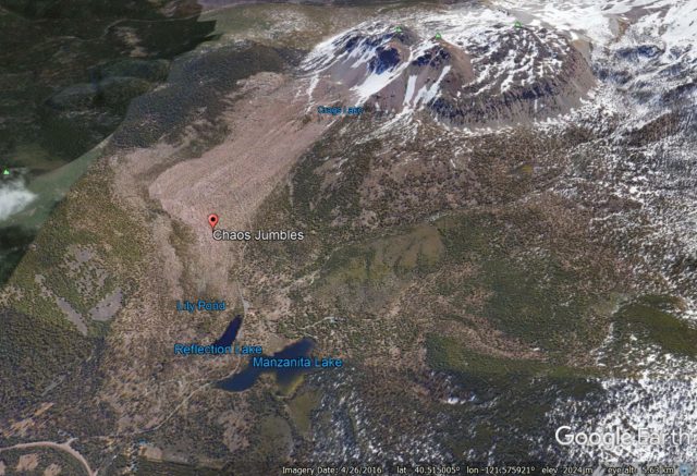
Google Earth imagery of the Chaos Jumbles rock avalanche deposits. Note the deposit of landslide III is almost unvegetated, but beneath this lie two other landslide deposits. Deposit I extends beyond Manzanita Lake.
.
The smallest and youngest deposit is easy to see – it extends from the large scar in the dome to just below te label that says Chaos Jumbles. Under this are two slightly earlier landslide deposits – these are clear in the map from Eppler et al. (1987) below:-
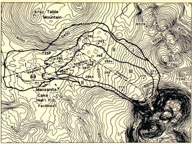
A map of the three Chaos Jumbles landslide deposits, from Eppler et al. (1987).
.
These are very large landslides – the runout of the largest extends about 4.5 km from the base of the dome, and the elevation change from the top of the scar to the toe of the landslide is about 650 m. The landslide cover an area of almost 7 km². The volume of the three landslides combined is thought to be about 120 million cubic metres, with the largest event (Deposit II) having a volume of about 50 – 70 million cubic metres.
A really interesting feature of this landslide deposit is the presence of very clear ridge structures in the landslide depsoits. These can be seen nicely in the Google Earth images collected when the sun was low:-
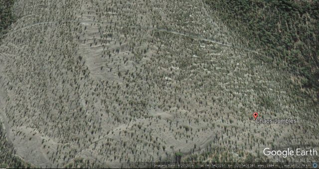
Google Earth imagery showing the clear ridge structures within the Chaos Jumbles landslide deposit.
.
These ridge and trough structures were taken by Eppler et al. (1987) to indicate that the landslide was undergoing compression and internal deformation in the later stages of its movement.
The cause of the collapses 350 years ago is not clear, but an earthquake is probably a strong candidate. Whilst the Chaos Jumbles landslides are of course not identical to those at Anak Krakatau, imaging what would happen if one of these landslides had entered the sea rather than running out across the desert plain serves to illustrate the processes in Indonesia. And note that there were three closely-spaced landslides at Chaos Jumbles; at Anak Krakatau one of the major worries is a further tsunami-generating collapse.
Reference
Eppler, D. B., Fink, J., & Fletcher, R. 1987. Rheologic properties and kinematics of emplacement of the Chaos Jumbles rockfall avalanche, Lassen Volcanic National Park, California. Journal of Geophysical Research: Solid Earth (1978–2012), 92(B5), 3623-3633.
27 December 2018
Tlalpujahua, Mexico: the Christmas town with a tragic landslide history
Tlalpujahua, Mexico: the Christmas town with a tragic landslide history
Mexico News Daily has an interesting article about the town of Tlalpujahua in Michoacán, Mexico. This town is renowned for the manufacture of Christmas ornaments:
“Tlalpujahua has a new form of gold. It comes in the shape of locally-made glass Christmas tree ornaments. Nowadays, visitors flock to the town to buy these artisan creations for their Christmas tree. For anyone who wishes it could be Christmas every day, Tlalpujahua is the place for you since these ornaments are found in stores throughout the year.”
But this success is built on tragedy. From about 1900 to 1937 Tlalpujahua was home to a highly productive gold mine. Then, on 27th May 1937, a catastrophic tailings landslide buried about a third of the town, killing at least 300 people. This pair of images shows the scale of the disaster:-
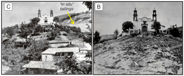
Before (left) and after (right) images of El Carmen church in Tlalpujahua. Note the houses on the lower slope before the failure, and the tailings on the hillslope behind. Images from Macías et al. (2015).
The landslide is described in a paper published a few years ago in the journal NHESS (Macías et al. 2015), which is open access (i.e. available for free download). This paper provides a detailed account and post-event investigation of this landslide. The landslide was triggered by a typical tailings dam failure, similar to recent events in Brazil, China and Australia, amongst many others, at a dump known as Los Cedros. About 16 million tonnes of waste were released to form a catastrophic debris flow, which travelled at speeds in the range of 20–25 m per second down the Dos Estrellas and Tlalpujahua channels, striking the town in the vicinty of El Carmen church (about 2.5 km downstream from the dam), burying them to a typical depth of 2 metres.
Macías et al. (2015) include this set of images of the aftermath of the debris flow at Tlalpujahua:-
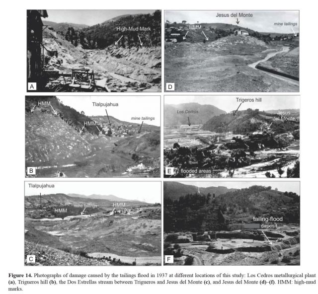
A montage of views of the aftermath of the Tlalpujahua tailings landslide in Mexico in 1937. Images from Macías et al. (2015).
.
The failure of the tailings dam at Tlalpujahua was triggered by a period of intense rainfall. The initiation of the failure began on 26th May, when a section of the dam failed. Macías et al. (2015) describe this as follows:-
“On 26 May at 17:30 [local time] a 4 tonne block detached from the lower part of the impoundment, leaving a 30m wide hole. After this small landslide, mine dam caretakers warned villagers downstream to leave their homes because a large landslide may occur. Unfortunately, only a few paid any attention and this warning went unheeded. That same day, at around 23:20, another block detached from the impoundment, flooding the road to the Los Cedros metallurgical plant and the Juarez bridge. Intense rain accompanied by lightning persisted throughout the night.”
The failure occurred the following day:
“At around 05:20 on 27 May, a large block (6 to 8 tonnes) of tailings collapsed, producing a din followed after a few seconds by a powerful air blast – which we interpreted as an air pressure wave – that flattened trees, fences, and houses. Eyewitnesses described the flood as a muddy to sandy, fetid mass that rapidly channeled into, and filled, the stream. The ensuing flood rushed downstream … Inhabitants felt the ground shaking caused by the flood impact. As the flood crashed against Trigueros hill, it diverted into an eastern upstream flood and a western downstream flood. The upstream flood flowed moved eastward a few hundred meters to the Los Cedros metallurgical plant, and then it waned and stopped. Instead the downstream flood rapidly transformed into a huge catastrophic wave at least 30 m in depth that swept towards the village of Tlalpujahua and San Jesus del Monte hill, which was crowned by a church. Between Los Cedros metallurgical plant and San Jesus del Monte hill at least eight neighborhoods were completely destroyed.”
…
“The huge rushing flood uprooted everything along its path as houses, trees, electrical poles, people, and animals were swept away. The electrical poles and wires downed by the flood generated short circuits, producing explosions, lightning, and gases. The explosions burned trees everywhere, initiating short-lived fires. During all this chaos, the windy storm persisted. Some people climbed the hills of Trigueros and San Jesus del Monte to save themselves. Survivors who reached these, or lived at higher elevations, described that the flood had the appearance of a fetid lake moving downstream … Eyewitnesses observed roofs, logs, furniture, and plants floating in the flood.”
This landslide, over 80 years ago, sounds very familiar. The tailings were located in an inappropriate site, upstream of population. The dam was improperly engineered. Early indications that a failure might occur were ignored or suppressed. Warnings were issued, but not systematically, so they were mostly ignored. And, finally, a period of heavy rainfall triggered collapse, with disastrous consequences.
This failure shows that the management of some tailings sites has been unacceptably poor for almost a century, and probably more. As I have noted previously on many occasions, we would not tolerate the level of catastrophic failure seen in tailings dams in any other geotechnical setting.
Reference
Macías, J. L., Corona-Chávez, P., Sanchéz-Núñez, J. M., Martínez-Medina, M., Garduño-Monroy, V. H., Capra, L., García-Tenorio, F., and Cisneros-Máximo, G. 2015. The 27 May 1937 catastrophic flow failure of gold tailings at Tlalpujahua, Michoacán, Mexico. Natural Hazards and Earth System Science, 15, 1069-1085, https://doi.org/10.5194/nhess-15-1069-2015.
26 December 2018
The Anak Krakatau landslide and tsunami
The Anak Krakatau landslide and tsunami
The disastrous and tragic landslide and tsunami from Anak Krakatau (Anak Krakatoa) has rightly dominated the news over the Christmas break. At least 429 people are known to have been killed, making this one of the worst landslide-induced disasters of the year, with a further 154 people thought to be missing. Severe weather, and in particular heavy rainfall, is making both the assessment of events to date and in the assessment of what might come next extremely challenging. Further landslides cannot be ruled out.
We can say with some certainty that the tsunami was triggered by a landslide from Anak Krakatau. There are two strong pieces of evidence for this. First, whilst it has not been possible to obtain visual satellite imagery of the island because of the weather, radar data (which is not obscured by cloud) has been available. The ESA Sentinel-1 satellite collected a decent image on 22nd December:-
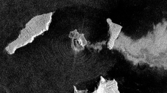
European Space Agency Sentinel-1 image dated 22nd December 2018 showing the deformation of Anak Krakatau. Copyright ESA, image accessed via Sentinel Hub.
.
This is a remarkable image, showing amongst other things the volcanic plume being blown to the east and the radial waves from the island being generated by the ongoing eruptions. But most importantly it shows what appears to be a large scarp to the west of the volcano cone, presumably marking a large-scale deformation (landslide) of the volcanic edifice of Anak Krakatau. There would have been a large submarine element to this, which presumably generated the tsunami.
Secondly, a strong seismic signal was generated by the landslide, which was detected on a number of seismometers. Jamie Gurney (@UKEQ_Bulletin) has done a great job of collating that information via Twitter. The seismic signal has a very strong low frequency component, characteristic of a landslide-induced, rather than a tectonic, event.
The challenge now is to interpret what might be happening on the volcano, and what might happen next. The latest Sentinel-1 image does not help:-
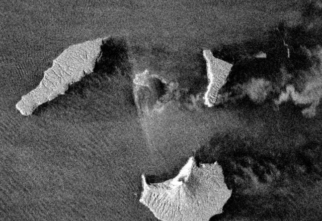
European Space Agency Sentinel-1 image dated 25th December 2018 showing the deformation of Anak Krakatau. Copyright ESA, image accessed via Sentinel Hub.
.
I am no expert on radar imagery, and others may be able to provide more information about what this shows. It seems to me that a large part of the island appears to be generating very little useful data – is this because of a drape of new deposits from the eruptions of the last few days? The upshot is, I think, that we cannot really interpret whether the volcano is deforming (or has deformed) further.
Quite rightly, the authorities are concerned about further landslides, but the only advice at this point is to stay away from the coast and to be vigilant.
Volcanic flank collapses are a well-known hazard, and the potential for the collapse of Anak Krakatau has been highlighted previously. These landslides have huge destructive potential but are inadequately researched when compared to many other hazards.
25 December 2018
Bureya River: a large landslide but not a meteorite impact in Russia
Bureya River: a landslide but not a meteorite impact in Russia
There are reports in various media outlets today about a large landslide on the Bureya River in the remote Khabarovsk region of Russia, which reportedly was triggered by a meteorite impact. The Siberian Times for example has the following report:-
Experts are at odds over the cause of an extraordinary landfall amid reports of hot rocks and extraterrestrial meteorite fragments on a 160 metre-high hill partially now damming the Bureya, a tributary of the Amur River. Some experts believe the phenomenon maybe a landslide but this is disputed especially by those who have visited the remote site, some 1,300 km by road from regional capital Khabarovsk.
Alexey Maslov, the head of Verkhnebureinsky district, said after witnessing the newly formed hill: ‘The riverbed is blocked by a bulk, about 600-to-800 metres wide.
‘The height is from 80 to 160 metres above the ice level. There is no radiation. An object entered at a sharp angle, pulled down a mound and spread it along the river bed. It is not clear what it is: maybe an explosion, a bomb, or a falling airliner.’
This is picked up by for example the Daily Mail:
“A massive landfall in eastern Russia was caused by a meteorite, a falling UFO or a massive bomb, it was claimed today. First pictures from a remote location in Khabarovsk region show how the 390 mile long Bureya River was partially dammed by a monumental rock fall. The top was severed from a large hill with rocks crashing down and forming a new 525 ft-high mound in the river bed.”
The location of the landslide is at: 50.559, 131.472. Satellite imagery suggests that it occurred between 04:49 UT on 11th December and 00:52 UT on 12th December 2018. This is a Planet Labs image of the failed slope and debris pile:-
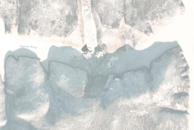
Planet Labs image of the landslide on the Bureya River. PlanetScope Ortho image collected 13th December 2018, used with permission.
.
The landslide appears to be about 500 metres wide and up to about 1.5 km long. It does appear to have blocked the Bureya River, although the debris pile does not appear to be excessively high close to the toe of the failed slope.
This is the slope before the snow arrived – this image was collected by Planet Labs on 19th October 2018:-
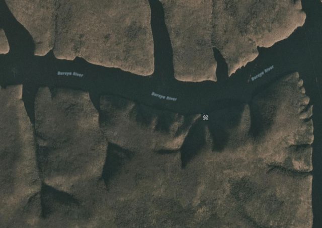
Planet Labs image of the landslide on the Bureya River. PlanetScope Ortho image collected 19th October 2018, used with permission.
.
From this imagery we can say that this is certainly a rockslope failure, and that it is highly unlikely to be associated with a meteor impact event. The slope appears to show a pre-existing tension crack or depression that aligns with the rear of the failed mass. This is at an elevation of about 580 m, the valley floor is at about 190 m.
This makes sense in light of the YouTube video from the Siberian Times article, which appears to show a conventional rock slope failure:-
.
The best understanding of the landslide comes from this still from the video:-
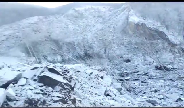
The source of the Bureya River landslide. Still from a Youtube video
It is a spectacular rock slope failure, with a quite mobile component. The speculation of a meteor event is incorrect. The slightly only surprising aspect is the timing – in cold areas rock slope failures mostly (but not exclusively) occur in the warmer months. An interesting aspect though is whether the depression to the west of the rear scarp is another extensional feature? If so there may be a larger failure yet to come.
Reference
Planet Team (2018). Planet Application Program Interface: In Space for Life on Earth. San Francisco, CA.
21 December 2018
The ancient Xuelongnang landslide in Tibet
The ancient Xuelongnang landslide in Tibet
In a recent paper in the journal Landslides, Chen et al. (2018) describe an ancient landslide at Xuelongnang in Tibet. This rockslide blocked the Jinsha River, creating a lake. The dating suggests that this partially breached soon after the formation of the dam, but water continued to be impounded for several hundreds of years before breaching once more. The landslide can still be clearly seen on Google Earth imagery – I have annotated the key aspects below:-
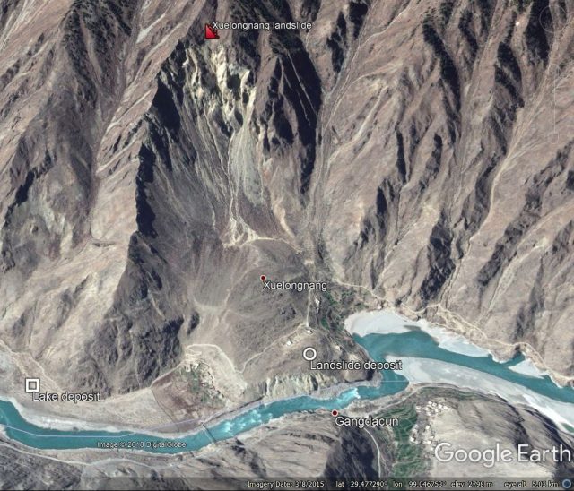
Google Earth imagery of the Xuelongnang landslide on the Jinsha River in Tibet.
.
The landslide symbol is at the crown of the very large and impressive landslide scar – according to Google Earth this is at an elevation of about 3,200 metres, whilst the valley floor is at about 2,420 metres, giving a vertical extent of over 750 metres. The remains of the landslide deposit are still clearly evident too, as is the channel formed during the breach events. Upstream, the broad plain of the lake deposit, formed when water was impounded behind the dam, is very clearly evident. The paper includes the following image which gives a better sense of the extent of the landslide:
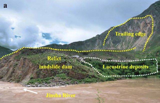
Annotated photograph of the Xuelongnang landslide on the Jinsha River in Tibet. Image from Chen et al. (2018).
Chen et al. (2018) have undertaken a very meticulous dating exercise on the landslide and lake deposits, providing insight into this multiple breaching process. They speculate that the trigger for the formation of the Xuelongnang landslide may have been a large earthquake about 2,100 years BP. This area is known to be tectonically-active, with known faults near to the landslide site and an instrumental record of earthquake events in the vicinity. Furthermore, a number of other large rockslides have been identified in close proximity to the Xuelongnang landslide. The authors found some evidence of another palaeolake deposit downstream of the landslide site, compatible with the valley suffering multiple landslide dam events. As such, there may be a similarity with the high density of large coseismic landslides in Papua New Guinea earlier this year.
Reference
Chen, J., Zhou, W., Cui, Z. et al. 2018. Formation process of a large paleolandslide-dammed lake at Xuelongnang in the upper Jinsha River, SE Tibetan Plateau: constraints from OSL and 14C dating. Landslides 15: 2399. https://doi.org/10.1007/s10346-018-1056-3
20 December 2018
Surabaya, Indonesia: an impressive retaining wall failure
Surabaya, Indonesia: an impressive retaining wall failure
On Tuesday night (18th December 2018) a spectacular retaining wall failure occurred in Surabaya in East Java, Indonesia. This landslide destroyed a 30 metre long section of the four lane Jl. Raya Gubeng, causing considerable traffic delays in the area. Images of the aftermath of the event suggest that it was a very substantial failure:-
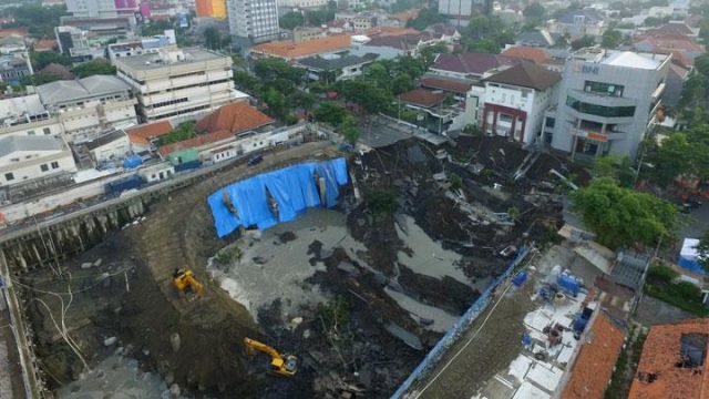
TRhe aftermath of the large retaining wall failure in Surabaya, Indonesia on Tuesday. Image via Tempo.
.
An article in the Malaysian Star has various statements confirming that it was a retaining wall failure:-
National Disaster Mitigation Agency (BNPB) spokesperson Sutopo Purwo Nugroho said the sinkhole was caused by a construction error.
“The retaining wall was not able to withstand the load, especially during the rainy season,” he said in a statement, adding that there was no connection between this incident and two active earthquake faults in Surabaya and Waru.
Surabaya Deputy Mayor Wisnu Sakti Buana said the sinkhole was allegedly related to the construction of a parking basement at Siloam Hospital.
“This is related to the project on the side of the road. The Siloam Hospital project. They were supposed to build a foundation first, but they didn’t,” Wisnu said as quoted in an interview with KompasTV.
Surabaya Development Planning Agency head Eri Cahyadi concurred, saying the incident was purely caused by an error in the project.
Meanwhile, Sutupo Purwo Nugroho also tweeted this image of the site, apparently showing the wall prior to failure:-
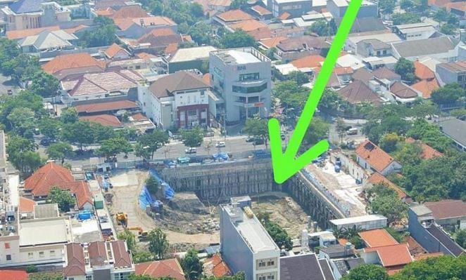
The retaining wall that failed at Surabaya, East Java in Indonesia on Tuesday night. Image Tweeted by Sutupo Purwo Nugroho.
.
Fortunately reports suggest that there were no casualties in this failure. Videos of previous events have shown how dangerous they can be.
Acknowledgement
Many thanks to Robert Kwok for highlighting this very interesting event to me.
 Dave Petley is the Vice-Chancellor of the University of Hull in the United Kingdom. His blog provides commentary and analysis of landslide events occurring worldwide, including the landslides themselves, latest research, and conferences and meetings.
Recent Comments