
26 February 2018
First reports of significant landslides from the Mw=7.5 earthquake in Papua New Guinea
Posted by Dave Petley
First reports of significant landslides from the Mw=7.5 earthquake in Papua New Guinea
At 17:44 UTC yesterday Papua New Guinea was struck by a Mw=7.5 earthquake. This was a shallow to moderately deep (early reports indicated 17 km, the USGS now indicates 35 km), reverse fault event under the New Guinea Highlands. This is an area known for significant landslides, suggesting that this earthquake is likely to have been able to generate large numbers mass movements. The area affected is remote and quite sparsely populated, indicating that human losses will hopefully be quite light. At the time of writing there are reports of ten deaths,at least five of which were the result of landslides.
This is the USGS Shakemap data for the earthquake, overlain onto Google Earth:-
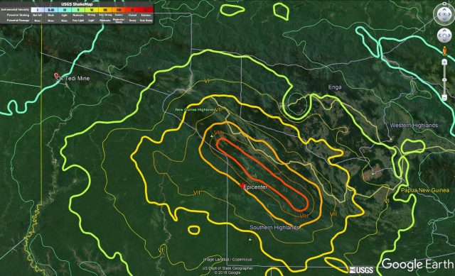
USGS Shakemap data on Google Earth imagery for the 25th February 2018 Mw=7.5 earthquake in Papua New Guinea
.
As yet there is little information about the impacts in the epicentral region. However, two posts have been placed on the Fly River Forum page on Facebook that show landslides triggered by the earthquake in the area of the Ok Tedi mine. I have indicated the location of the Ok Tedi mine on the map above – you will see that it is about 210 km from the epicentre. The Ok Tedi mine is infamous for the huge (70 million cubic metre) rock avalanche that caused damage and a major release of tailings into the Fly River in 1989. Subsequent work indicated that this is an area with large numbers of existing landslides; it is generally inferred that this is representative of conditions across the upland areas of Papua New Guinea.
The images posted today on Facebook seem to indicate that the Ok Tedi mine has been impacted by coseismic landslides. Luke L Purre has posted a series of images of the are, including this one:
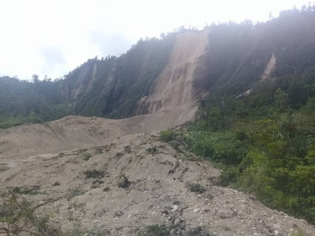
Image by Luke L Purre and posted on Facebook showing a landslide triggered by the Mw=7.5 earthquake in Papua New Guinea on 25th February 2018
.
Whilst Baundo Mereh posted this image:-
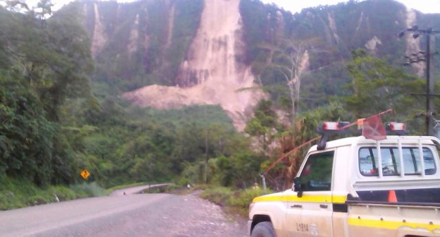
Image by Baundo Mereh and posted on Facebook of a landslide triggered by the Mw=7.5 earthquake in Papua New Guinea
.
Whilst both images show the same landslide, the second appears to show a number of smaller rock slope failures as well. The main failure, which has reportedly shut down production, appears to be a major rock slope failure that has transitioned into a flow.
It seems highly likely that there are many more landslides in the epicentral area, probably highly concentrated on the hanging wall side of the fault with a few kilometres of the rupture (if it has broken the surface). The landslide-affected area will probably extend some tens of kilometres to the northeast of the fault rupture, into the mountains.
One very interesting aspect of this event is that the terrible Tumbi Quarry Landslide in 2012 occurred right in the heart of the epicentral area. It will be interesting to see how the infrastructure associated with the Esso Highlands pipeline has stood up to the landslides triggered by this major earthquake.
 Dave Petley is the Vice-Chancellor of the University of Hull in the United Kingdom. His blog provides commentary and analysis of landslide events occurring worldwide, including the landslides themselves, latest research, and conferences and meetings.
Hi Dave, thanks for your great blog.
The 7.5 earthquake in PNG was directly below Mt. Sisa, an 8700′ dormant/extinct volcano in the Southern Highlands Province. There have been 46 aftershocks greater than 4.5 so far, mostly south-east of the main quake, including two with mag. 6 or higher.
Magnitude 7.5
Time 2018-02-25 17:44:44 (UTC)
Location 6.149°S 142.766°E
Depth 35.0 km
Mt. Sisa is a strato volcano, last eruption >12,000yrs ago (Pleistocene)
Latitude 6.13°S Longitude 142.73°E
Summit Elevation 8692 ft
Global Volcanism Program Volcano Number 253801
Can you tell me if this has caused the Fly River to be polluted? Has the Ok Tedi copper mine which is in the north of PNG’s Western Province had its copper ore pipelines badly damaged? If there has been any rupturing, then the stuff that comes out of the pipeline has the potential to greatly harm the environment. The catchment areas of the Ok Tedi River (and the much larger Fly River, which the Ok Tedi River empties into), are the area most likely to be badly affected with poisoning of fish and other water creatures, killing of riverside trees, etc. Do you know if this is happening?