27 February 2018
An update on landslides from the Mw=7.5 Papua New Guinea earthquake
Posted by Dave Petley
An update on landslides from the Mw=7.5 Papua New Guinea earthquake
Information is slowly emerging regarding the impacts of landslides from the Mw=7.5 Papua New Guinea earthquake. Unfortunately the area remains too cloudy to allow useful optical band satellite imagery to be obtained by Planet Labs, but I will keep an eye on this over the coming days. Meanwhile media reports suggest that landslides may have been a significant factor – that is not a surprise in an upland area. The most informative report that I have seen today is from the Post Courier, which indicates at least 31 fatalities, a large proportion of which may have been from landslides:-
Sketchy reports indicated that more than 13 people have been reportedly killed in the Southern Highlands capital Mendi, while another 18 people have also been reportedly killed in the most affected areas of Kutubu and Bosave…Unconfirmed reports from Mendi said that the earthquake was so powerful that people did not sleep, while there has been reports of landslides, landslips and sinkholes in several places and deaths.
RNZ has a more detailed report of the impact of the landslides themselves:
A police spokesman said there were also reports of entire hillsides coming down and whole villages being buried by landslides. Mr Tens told RNZ Pacific from Mendi that rescuers were trying to reach four people buried in a landslide. He said power and telecommunications were still out in most of the affected areas and the main roads into the region were cut off by landslips … According to police spokesman Dominic Kakas, at least 10 people died in landslips. Superintendent Kakas said the quake and its after shocks have caused widespread movement of land in the provinces of Southern Highlands, Hela, Enga and Western Province. He said reports are filtering through of extensive damage. “To roads, landslips, entire mountains coming down, from reports some villages have been covered. The telephone lines the towers have been damaged, so yeah.” … Earlier, Catholic priest Father Pius Hal told the Papua New Guinea Today website two children of a local government leader were among five killed by quake-triggered landslips in Mendi town.
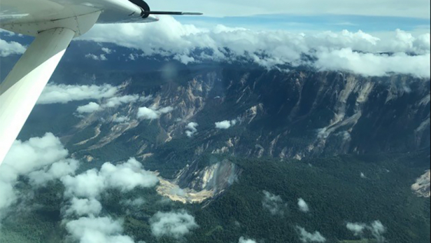
MAF has published this image of the earthquake affected area, which also indicates extensive landslides:-

MAF image of landslides triggered by the Papua New Guinea earthquake
.
As expected these are mostly disrupted shallow rockslides, but note the large, deeper-seated rock slope failure, with some evidence of flow, towards the bottom of the image.
Clearly the situation in the remote uplands of Papua New Guinea remains extremely uncertain; it is likely that it will be some days before we really understand the impacts of the this earthquake. There is of course an urgent need to determine as to whether there are any valley-blocking landslides in the hills.


 Dave Petley is the Vice-Chancellor of the University of Hull in the United Kingdom. His blog provides commentary and analysis of landslide events occurring worldwide, including the landslides themselves, latest research, and conferences and meetings.
(i)… big rivers like the Tagali and Hegego have been blocked and building up dams, threatening lives down stream in Kutubu and the Gulf Province. …(/i)
https://postcourier.com.pg/quake-rocks-shela-shp/
The mag 4.5+ aftershock count is now at 54 with the last dozen or so at 10km. depth vs around 35km for the earlier quakes.
Main problem is that blocking roads to the epicenter area is an exeggerated item as there are almost no roads at all, just trails + almost nobody in the international community seems to care. Why not using the mining companies choppers to assess the situation. The authorities in PNG have nearly anything to use.
The situation is not new at all. During last massive below land eq, it took 5!!! days before a SAR/rescue team could reach the epicenter area. What is happening now in PNG is a disgrace.
YouTube video of multiple valley blocking slides
https://www.facebook.com/bernard.j.mcqueen/posts/1311390248960475