
16 January 2018
Satellite images of the Montecito debris flows in California
Posted by Dave Petley
Satellite images of the Montecito debris flows in California
Last week significant debris flows struck the Montecito area of California. At least 20 people were killed, with a further four people reported as being missing. The highly mobile flows barreled down three major gullies, the Montecito, San Ysidro, and Romero creeks in the hills to the north of the community. This area was severely burnt by the Thomas Fire in December. The vulnerability of the area affected by the fire to landslides had been highlighted in advance.
Planet Labs have now imaged the area affected by the landslides, and have kindly made the imagery available to me. Once again I am amazed at the quality of the images that they are able to collect. This image, collected on 10th January, 2018, shows the area affected by the landslides:-
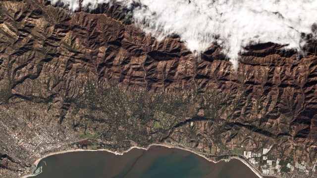
Planet Labs image of the Montecito debris flows area
.
Note the severely burnt and eroded area to the north of the town. and the obviously denuded hillsides that were the source of the flows. The high resolution Planet Labs image below provides a perspective on the area affected by the flows themselves:-
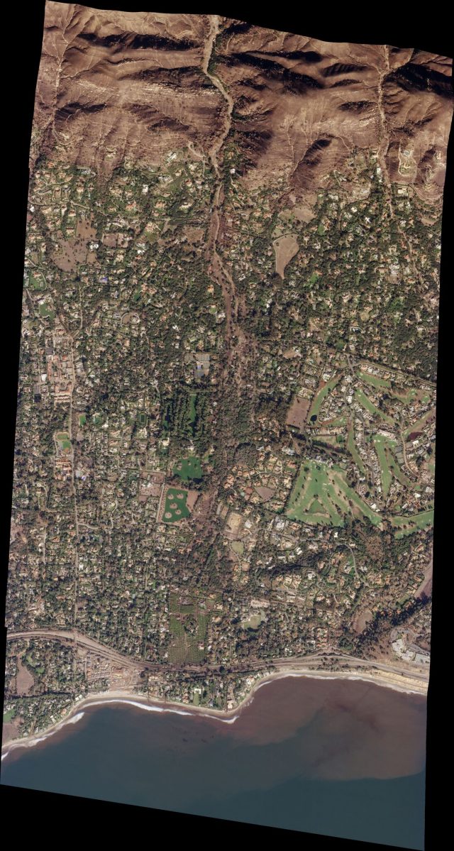
High resolution Planet Labs image of the Montecito debris flows
.
The flow emerging from the gully is clear in the image once you look carefully. The imagery shows the extraordinary trail of destruction left by the flows all the way from the mouth of the gully to the coast. This is a more detailed image of the area close to the mouth of the gully:-
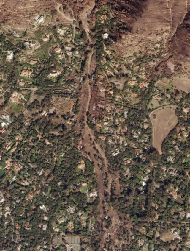
Planet Labs image of the damage caused by the Montecito debris flows.
.
The swathe of destruction caused by the flows is clear – in places it is even possible to see partially buried houses. This damage continues to a greater or lesser extent all the way to the coast. The image below shows the southern part of the town – note the inundation on the east-west highway:
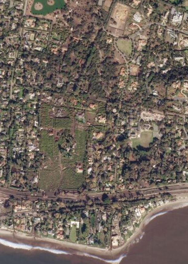
Planet Labs image of the southern part of the Montecito debris flows
.
Reference
Planet Team (2017). Planet Application Program Interface: In Space for Life on Earth. San Francisco, CA. https://api.planet.com
 Dave Petley is the Vice-Chancellor of the University of Hull in the United Kingdom. His blog provides commentary and analysis of landslide events occurring worldwide, including the landslides themselves, latest research, and conferences and meetings.
John McPhee did a classic story (published in two parts) in the New Yorker in 1988 discussing the fire-rain-debris flow cycle in California.
https://www.newyorker.com/magazine/1988/09/26/los-angeles-against-the-mountains-i
https://www.newyorker.com/magazine/1988/10/03/ii-los-angeles-against-the-mountains
It is a must-read for understanding the many technical and societal aspects of these cyclical events.
Here is an interesting article looking at the current state of landslide mapping and potential improvements to include potential run-out areas, since that is where much of the damage comes from.
https://theconversation.com/deadly-california-mudslides-show-the-need-for-maps-and-zoning-that-better-reflect-landslide-risk-90087
This story is also published as one-third of his highly recommended book The Control of Nature
There does not appear to be any form of ownership for hillside monitoring and landslide warning/prevention in California. For days I have been trying to establish whom we (Hesotech; check out https://www.hesotech.de/landslide/ ) might contact in the State to draw attention to our effective and low priced monitoring and alarming system.
So far, I have screened:
the Governor’s Office
(including the Office of Innovation, Risk and Strategic Management),
CalTrans,
the Coastal Commission,
the California Natural Resources Agency,
the Office of Planning and Research,
the California Emergency Management Agency,
the Department of Water Resources,
the State Coastal Observing Systems (there are several),
the league of Cities (representing nearly all 482 cities in California),
the California State Association of Counties (representing 58 counties in the state)
and a vast number of Special Associations (which seem to be counted as local governments).
In addition, I have looked at the following official documents:
Emergency Services Sector Plan Safeguarding California,
2009 California Climate Adaption Strategy,
California Coastal Commission Strategic Plan 2013-2018
(together with Coastal Commission Strategic Plan Action Implementation Dashboard – Year 2 – Updated as of May 2015)
and the California Transportation Asset Management Plan.
All these sources deal with measures to be taken after the event but no trace of ownership for monitoring and prevention of landslides anywhere in California.
I have not done the screening you have on landslide monitoring but the bottom line is that hill side monitoring is much like trying to predict earthquakes. The bottom line is this: Humans build in the path of hazards, and regions such as the steep mountain slopes, base of mountains, and paleo flood planes of creek channels to name a few, should never have been developed. The solution in the future is to prohibit development of these areas in urban planning which integrates geo hazards assessment. Some events simply can’t be mitigated due to spatial constraints and/or the magnitude of the event. There is a need for educating the community on how to prepare for natural disasters and awareness of the types of disasters they are up against. I believe that the 20 lives lost in the recent southern California debris flow following the Thomas fire could’ve been avoided had those involved with establishing the mandatory evacuation zones backed them with scientific analysis and residents within this zone were forced to leave. The conditions for the event were prime and the weather coming was predicted 3 days in advance.
I would start by talking to the county Flood Control Districts. They are the boots on the ground dealing with these issues, including designing, building, and maintaining the debris basins etc. If they see a way it would help their operations, then they might be interested.
Is it possible to obtain the Montecito Debris Flow Devastation imagery?